68 F. high in the Twin Cities Wednesday.
74 F. average high on September 10.
81 F. high on September 10, 2013.
September 10 in Minnesota Weather History. Source: Twin Cities National Weather Service:
1980: 3.35 inches of rain fell in the St. Cloud Area.
1942: A line of thunderstorms raced across Minnesota at 70 mph, destroying 651 barns in a 30 mile wide, 180 mile long path.
1931: Summer still had its grip on Minnesota with 111 degrees at Beardsley.
1931: The daytime high in St. Cloud was 96 degrees.
1900: The soggy remains of the Galveston Hurricane brings 6.65 inches of rain to St. Paul over two days.
1807: Thick smoky weather noted at Pembina.
Instant October
I'm afraid to check the news. Between ISIS, Ebola and Ray Rice it's no wonder the heart monitor on my new Apple Watch sounds like a bongo drum on fast-forward.
In a perfect world (it ain't) the weather report would be an antidote to all the darkness lurking out there. At least we can do something about the weather, prepare ourselves for whatever comes next.
At the risk of burying the lead, this premature shot of October does not mean that another harsh winter is imminent. A stubborn polar vortex in early 2014 resulted in the most extreme winter in 30 years for Minnesota. The odds of an identically-brutal winter, statistically, are small.
That said, the same upper level feature (hot, dry ridge of high pressure in the west - frequent shots of Canadian air east of the Rockies) has been remarkably persistent, and sweatshirt weather spills over into Saturday.
The sun peeks out today; a reinforcing front sparks more rain showers Friday. A light frost can't be ruled out Saturday morning outside the Twin Cities metro but 60s return next week. Plenty of September left to go.
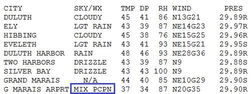
Tell that to residents of Grand Marais, where it snowed yesterday.
Um, maybe it's time to tune in CNN, just to catch my breath.
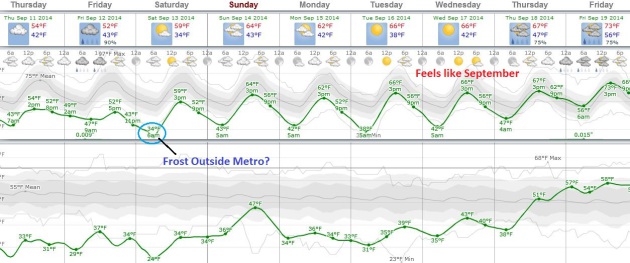
Chilly
Spell - September Rerun Next Week. Plan on 50s today and Friday, when a
southern system may brush southern Minnesota with a few showers. Skies
clear Friday night, and if winds subside a light frost can't be ruled
out over parts of central and southern Minnesota, although probably not
in the immediate metro. 60s return next week, maybe 70s by the end of
the week. MSP Meteogram: Weatherspark.
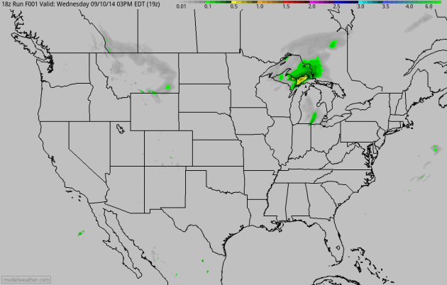
Premature Smack.
Yes, it's early to be tracking a cold front, the first real spasm of
chilly, Canadian air. Heavy showers and T-storms push across the Ohio
Valley and Great Lakes into New England today; a second system pushes a
cold rain into the Dakotas with a few rain showers possible south of the
Minnesota River by Friday. 4 KM NAM 60-hour accumulated precipitation:
NOAA and HAMweather.
Hope For A Strong El Nino Fade in Parched California.
Because it's the intense El Nino warming events in the Pacific that
often divert wet storms into central and southern California. More
details in this clip from a New York Times story: "...Long-term
weather forecasters say it is now unlikely that a strong El Niño will
develop this fall, dimming hopes in California for heavy rains that
might bring relief from a severe drought. In its latest monthly forecast,
the federal Climate Prediction Center in College Park, Md., said that
while there was still about a two in three chance that El Niño would
develop, perhaps in the next two months, it would most likely be weak..."
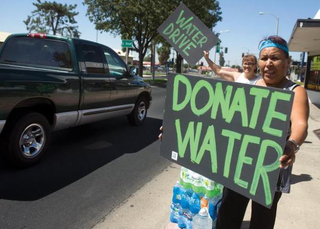
Photo credit above: "Volunteers
appeal to community members for donation Saturday, Sept. 6, 2014 at the
Porterville Water Challenge on Olive Street in Porterville, Calif.
Several locals started their own water challenges to help East
Porterville area residents whose well went dry for months." (AP Photo/The Porterville Recorder, Chieko Hara).
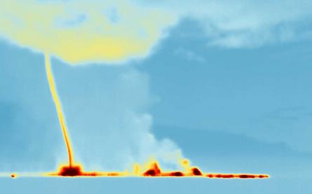
Tornado of Hot Gas Caught Emerging from Fiery Volcano. Here's a clip from an interesting piece at New Scientist: "This is pretty hot stuff. A swirling 1-kilometre-high tornado of gas has been caught emerging from the lava pouring out of a fissure on Iceland's Bardarbunga volcano. The image was captured on 3 September by an infrared camera designed for aircraft, to let pilots see volcanic ash clouds. It is not entirely clear what is causing the tornado, says Fred Prata, inventor of the ash camera at Nicarnica Aviation in Kjeller, Norway..."
Image credit: nicarnicaaviation.
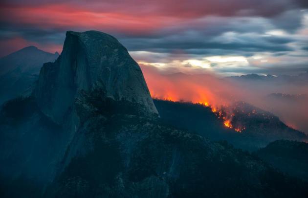
The Most Beautiful Wildfire Photos You'll Ever See.
I know "beautiful wildfire" is right up there with "jumbo shrimp" and
"Senate Intelligence Committee". Serious oxymoron. But here's a clip
from a story at Time that's worth a look: "...At
first, you don’t see the fire and smoke raging near the most beautiful
section of America’s most beautiful national park. Instead, the blaze
that’s burned through 4,500 acres of Yosemite blends almost seamlessly
into its natural features: the fire looking an extension of the sunset;
the smoke appearing nothing more than a layer of fog above the valley
floor. Photographer Stuart Palley captured the wildfire when it first
began spreading early this week..."
Photo credit: Stuart Palley. "The
Meadow Fire burns overnight near Half Dome in Yosemite National Park
early Monday September 8, 2014. As of Wednesday the fire had burned over
4,500 acres and was 10% contained."
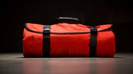
"Tornado Shield" Helps Protect Against Storm-Flung Debris.
Let's hope it's an EF-0 or EF-1 tornado, but any chance you have to
protect yourself against flying debris is a good thing. Details on this
new contraption via Gizmag: "...After
zipping yourself into the Tornado Shield, you then lie down on the
floor in the safest place you can find (such as a bathtub). While it
won't keep you from being crushed, its ballistic nylon construction is
intended to protect against lacerations caused by flying bits of debris –
such injuries are the most common type suffered by tornado victims.
Steve has tested the material against various glass, metal and wooden
objects, of the type that might be whizzing through the air in a
building being demolished by a tornado..."

Apple Watch is the Long-Rumored iWatch. Gizmag has a good rundown on what you may or may not be wearing on your wrist in 2015; here's a clip: "...We’ve
developed multiple technologies and an entirely new user interface
specifically for a device that’s designed to be worn. It blurs the
boundary between physical object and user interface,” said Jony Ive,
Apple’s senior vice president of Design. Apple also introduced something
called "Glimpses" for the watch that are essentially the same as the
cards that Android Wear users are familiar with that show useful
information like location, weather and upcoming appointments. Siri is
also accessible and the Apple Watch allows you to respond to texts via
dictation..."

Here's How Apple Will Convince You To Buy a Smartwatch. New York Magazine has the article; here's an excerpt: "...For
all the hemming and hawing about the devices Apple released yesterday —
the tech specs, the dimensions, the informed analysis of How It Will
All Work Together — the most overlooked aspect of the entire day was
that Apple gadgets have always been, and will always be, pure fetish
objects. Our iPhone, iPad, and Macbook Air purchases may end up helping
us be productive at work, or saving us time on the go, but our decision
to buy them always starts with the same thought: This looks cool and I want one."

Buy Condo, Then Add Parking Spot for $1 Million. I smell another bubble coming. Here's an excerpt of a head-scratching tale at The New York Times: "What will $1 million buy in New York City?
A diamond-encrusted Cartier men’s watch. A small fleet of 2014 Bentley
Continentals. Or maybe your very own parking spot in SoHo. A new
development, 42 Crosby Street, is pushing the limits of New York City
real estate to new heights with 10 underground parking spots that will
cost more per square foot than the apartments being sold upstairs..."
Photo credit above: "A rendering of an apartment building in SoHo that will offer buyers parking spots at $1 million apiece." Credit Vuw + Moso.
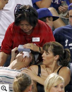
Baseball Caught Looking As Fouls Injure 1,750 A Year. I had no idea. Here's a snippet from a story at Bloomberg: "...About
1,750 spectators get hurt each year by batted balls, mostly fouls, at
major-league games, or at least twice every three games, a
first-of-its-kind analysis by Bloomberg News has found. That’s more
often than a batter is hit by a pitch, which happened 1,536 times last
season, according to Elias Sports Bureau Inc.
The 8-year-old boy was one of four fans injured at the May 20 game,
according to a “foul-ball log” and other first-aid records at the
Braves’ Turner Field..."
Photo credit above: Rodger Mallison/Fort Worth Star-Telegram via AP. "An
usher, upper center, gives first aid to a fan after he was hit in the
face by a foul ball during a baseball game between the Texas Rangers and
the Oakland Athletics in Arlington in July 2011."
TODAY: Partly sunny & brisk. Dew point: 37. Winds: N 10. High: 57
THURSDAY NIGHT: Clearing and cool. Low: 43
FRIDAY: Raw with clouds, few showers. High: 54
SATURDAY: Slight frost risk outside the metro early. Bright sun. Wake-up: 36. High: near 60
SUNDAY: Mix of clouds and sun, pleasant. Wake-up: 42. High: 63
MONDAY: Some sun, still cooler than average. Wake-up: 44. High: 59
TUESDAY: Bright sunshine, very nice. Wake-up: 40. High: 64
WEDNESDAY: Sunny intervals, a bit milder. Wake-up: 48. High: 66
Climate Stories....
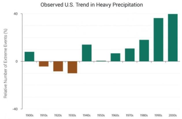
Graphic credit above: "Decadal index of two-day precipitation totals that are exceeded on average only once in a 5-year period. Changes are compared to the period 1901-1960. As data show, such once-in-five-year events have become much more common (via NCA.)"
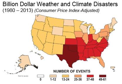
Map credit: NOAA NCDC.
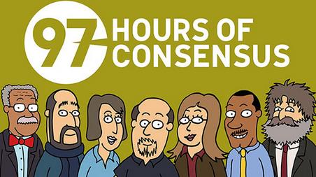
Cartoon credit above: The Consensus Project.
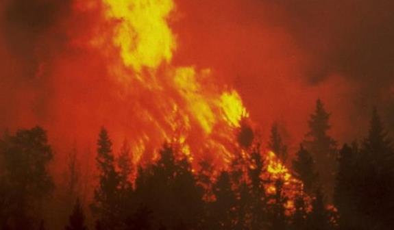
Photo credit above: "Scientists at the Pacific Northwest Climate Science Conference in Seattle said modeling suggests large wildfires are increasingly likely to occur going forward." Flickr/Washington DNR.

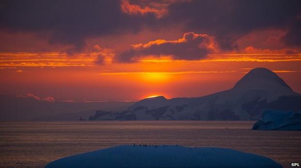
Photo credit above: "Concentrations of CO2 in the atmosphere rose rapidly in 2013." Source: SPL.
No comments:
Post a Comment