51 F. high in the Twin Cities Saturday.
64 F. average high on October 4.
59 F. high on October 4, 2013.
.03" rain fell yesterday.
No snow reported Friday night at MSP International.
.6" snow reported at Eau Claire, Wisconsin yesterday,
earliest measurable snowfall on record.
October 4, 1963: Heat wave across area with 98 at Beardsley, 96 at Madison, and 94 at Elbow Lake.
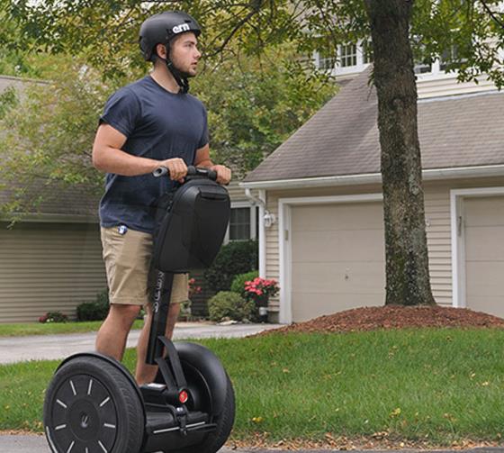
Running in Place
My
dream is to one day finish the Twin Cities Marathon in first place in
my age division - cheerfully waving to the crowd from a Segway Scooter.
It probably won't happen, but it's good to dream.
My wife is a
marathon runner and after consulting her I've reached the conclusion
that weather should be nearly ideal for today's Twin Cities Marathon:
temperatures rising from the mid-30s into the mid-40s with a mix of
sunshine and scrappy cumulus clouds; a west breeze at 5-15 mph pushing
you toward the finish line in St. Paul.
Good luck.
We will
all participate in the annual Minnesota Winter Weather Marathon, which
runs about 6 months or so. Last winter's pattern became locked in a
blocking pattern that funneled arctic air into much of the USA. The QBO,
or quasi-biennial oscillation, tracks winds near the stratosphere that
increase the risk of these stubborn blocks forming. So far the trends
are diametrically opposite of last year, to date. I don't think this
winter will be nearly as harsh as last.
A cool, dry week gives way to showers next weekend. Just rain, no snow in sight. No warm fronts brewing but no drama either.
Today Tokyo may see a direct hit from Typhoon Phanfone.
Perspective.
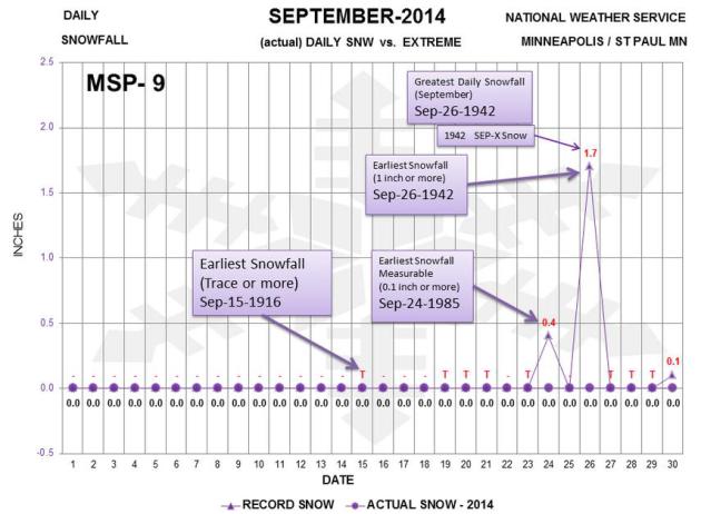
Thanks to the Twin Cities National Weather Service for putting Friday
night's snowy near-miss into perspective. The earliest trace of snow on
record: September 15, 1916. Nearly 2" of snow fell on September 26,
1942. I can only imagine how thrilled the locals were back then.
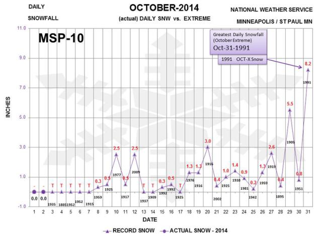
October Extremes.
Here's a good, day-by-day analysis of daily snowfall records for
October. Of course the record goes to Halloween, 1991, as the
(memorable) Halloween Superstorm kicked in: 8.2", on our way to close to
30" over 3 days as a storm stalled over Lake Superior. I'll take that
one to my grave...
PUBLIC INFORMATION STATEMENT
NATIONAL WEATHER SERVICE CHICAGO IL
707 AM CDT SAT OCT 4 2014 /807 AM EDT SAT OCT 4 2014
...CHICAGO ILLINOIS RECORDS THIRD EARLIEST SNOWFALL ON RECORD...
THE
WEATHER OBSERVER AT CHICAGO OHARE CONFIRMED THAT SNOW WAS OCCURRING.
THIS SNOW IS THE THIRD EARLIEST SNOWFALL TO BE OBSERVED AT CHICAGO
DATING BACK TO 1884. THE EARLIEST SNOWFALL TO OCCUR IN CHICAGO WAS ON
SEPTEMBER 25 IN 1928 AND 1942 WHEN A TRACE FELL. THE AVERAGE FIRST TRACE
OF SNOW AT CHICAGO IS OCTOBER 30TH.
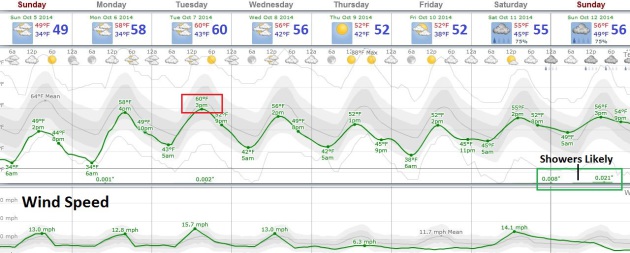
Chilly Sunday, Then Slight Moderation.
I'm not sure I'd call a shot at 60F Tuesday a warm front, more of a
not-as-cold front, but the next few days should feel a little more like
October. Highs clip 50 today, then rise to near 60F Tuesday before
cooling off slightly late in the week. Any significant rain passes south
of Minnesota until a more formidable front arrives next weekend.
Graphic: Weatherspark.
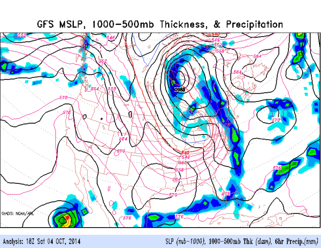 Continuing Cool Bias Northern USA.
An intense storm rotating around Hudson Bay keeps cool exhaust flowing
into the Upper Midwest, Great Lakes and New England in the coming days,
unusually cool air pushing as far south as Florida. Any significant
rains pass well south of Minnesota until late week, when the next
long-wave trough pushes showery rains into Minnesota. Yes, the
atmosphere should be warm enough for liquid precipitation. Source: NOAA
ARL.
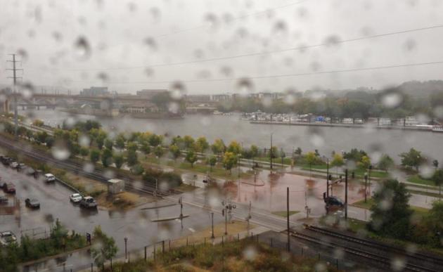
Wet Start to October - Will Harvesting Be Impacted? Dr.
Mark Seeley takes a comprehensive look at weather trends; highlighting a
possible impact/delay on the corn harvest due to a very wet start to
October. Here's an excerpt of this week's
WeatherTalk Newsletter: "...
Winona
reported 1.36 inches and Caledonia 1.81 inches, while in the Twin
Cities Metro Area MSP airport reported 1.47 inches and the University of
Minnesota St Paul Campus 1.20 inches. Well over half of the state's
corn crop has reached physiological maturity now and a majority of the
soybeans have dropped their leaves. As the corn and soybean harvesting
season gets underway in earnest this month Minnesota farmers will be
hoping for a series of dry days to get some harvesting done. It appears
that patience will be required waiting for a warm and dry interval of
weather..."
Vikings Stadium Crane Operators Swing Carefully From 300 Feet In Air. And you thought you had an interesting gig? Here's a snippet from a
Star Tribune article: "...
The
highest point of the structure — the west prow, which is now in place —
soars to 270 feet. The cranes Koebnick and his colleagues run go even
higher than that, reaching 300 feet and providing a panoramic view of
car crashes, police chases and the incoming weather system at the
farthest reaches of the horizon. The crane operators make the long climb
to the top each morning and don’t return to earth until quitting time,
often 12 to 14 hours later. Their lunches go up with them, and they tend
to nibble all day rather than take a break or relax over a sandwich.
For the call of nature, they each have a 5-gallon bucket..."
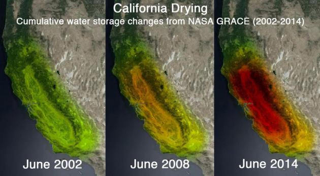
NASA Satellites Put California Drought Into Shocking Perspective.
Mashable has the story - here's the introduction: "
Newly
released images created from NASA satellite data illustrate the
staggering effect the California drought has had on groundwater supply
in the state. The images show the amount of water lost over the past 12
years, with different colors indicating severity over time..."
Image credit: UC Irvine, NASA.
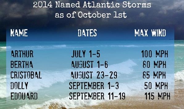
2014 Hurricane Season Winding Down With Only Five Named Storms.
It's been a very busy hurricane/typhoon season in the Pacific, but
unusually quiet (again) in the Atlantic. Here's an excerpt of a good
recap from meteorologist Steve Rudin at
WJLA-TV in Washington D.C.: "...
With
less than two months to go, the 2014 Atlantic hurricane season has been
lackluster at best. Earlier this year, NOAA predicted near-normal to
below-normal tropical season. One factor could be the development of El
Niño along with cooler Atlantic water temperatures. The original
forecast was for eight to 13 named storms, three to six becoming
hurricanes and one or two becoming major hurricanes..."
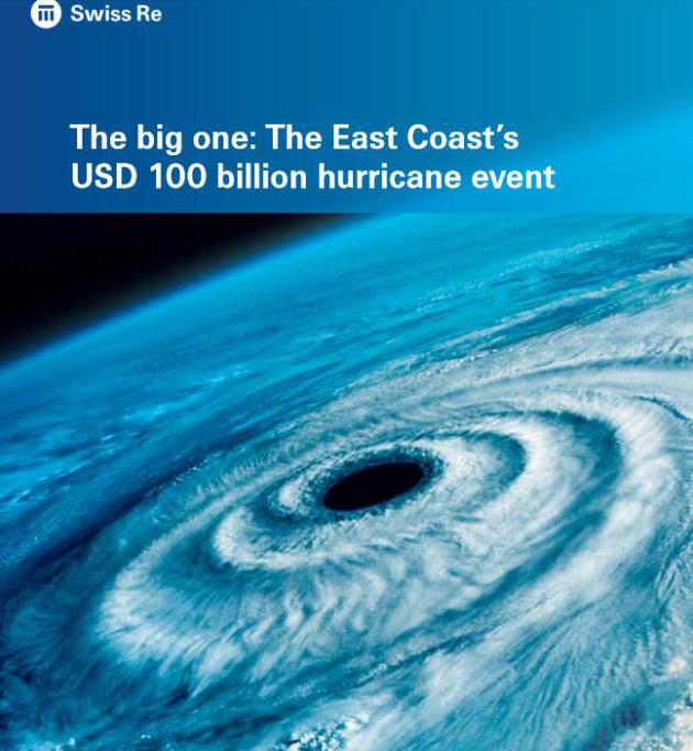
The Freak Hurricane of 1821 And Why It Should Worry Every Mid-Atlantic and Northeast Coastal Resident.
I'm feeling better about living in the Upper Midwest, in spite of the
fresh slaps of Canadian air. Here's an excerpt from meteorologist Jason
Samenow at
The Capital Weather Gang: "
Nearly
200 years ago, a devastating hurricane with sustained winds up to 130
mph crashed into the North Carolina Outer Banks. This beast of a storm
than roared up the East Coast, inflicting immense damage in Norfolk,
swamping Cape May and raising New York’s East River 13 feet in one hour.
Re-insurer Swiss Re, which analyzed this storm, says such a storm today
would cause over $100 billion in damages, and prove 50 percent more
costly than 2012′s Superstorm Sandy, in a recent report “The big one: The East Coast’s USD 100 billion hurricane event...”
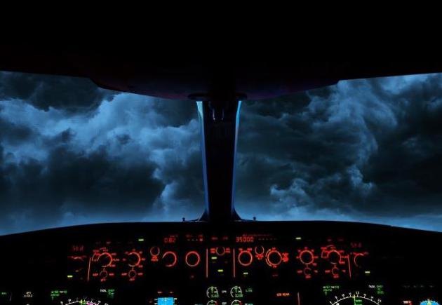
The Human Factor.
Automation in the cockpit is generally thought to be a good thing, but
is too much automation making it difficult or even impossible for pilots
to cope when things go really wrong? Here's a summary of a long, but
excellent article at
Vanity Fair: "
Airline
pilots were once the heroes of the skies. Today, in the quest for
safety, airplanes are meant to largely fly themselves. Which is why the
2009 crash of Air France Flight 447, which killed 228 people, remains so
perplexing and significant. William Langewiesche explores how a series
of small errors turned a state-of-the-art cockpit into a death trap..."
Image credit above: Sean McCabe. "TROUBLE AHEAD
Inside the automated cockpit of an Airbus A330—like the one belonging
to Air France that crashed into the equatorial Atlantic in 2009."
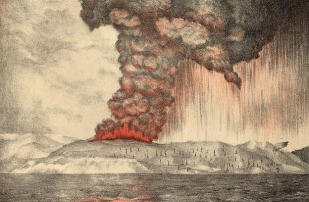
The World's Loudest Sound.
Kottke.org
has a fascinating story about the debilitating and life-threatening
impact of unimaginable noise at close range. Imagine the loudest concert
you've ever attended. Multiply by 100. Here's an excerpt: "
The
sound made by the Krakatoa volcanic eruption in 1883 was so loud it
ruptured eardrums of people 40 miles away, travelled around the world
four times, and was clearly heard 3,000 miles away.
Think, for a moment, just how crazy this is. If you're in Boston and
someone tells you that they heard a sound coming from New York City,
you're probably going to give them a funny look. But Boston is a mere
200 miles from New York. What we're talking about here is like being in
Boston and clearly hearing a noise coming from Dublin, Ireland..."
Failing Sense of Smell May Predict Sooner Death. Nose, don't fail me now. Here's the intro to a fascinatingly troubling article at
The New York Times: "
A
defective sense of smell appears to be a good predictor of dying within
five years, a new study has found. Researchers tested a nationally
representative sample of 3,005 men and women aged 57 to 85 on their
ability to identify five smells: rose, leather, orange, fish and
peppermint. The study appears online in PLOS One..."

Google Glass Now Plays Movie Trailers, Close Captions Your Conversations. If done right this could be a big breakthrough for the hearing-impaired.
Gizmag has the details; here's a clip: "
Google Glass
hasn't exactly set the world on fire – or, for that matter, even left
beta status. But that doesn't mean there aren't still some cool
potential uses for the headset. Today Glass has two big new apps: one
that can turn it into a life-changing tool for the hearing-impaired, and
another that, erm, helps movie theaters sell tickets..."
TODAY: Partly sunny, brisk. Winds: 8-15. High: 52
SUNDAY NIGHT: Partly cloudy. Low: 37
MONDAY: More clouds, stray shower possible. High: 57
TUESDAY: Mix of clouds and sun, still cool. Wake-up: 40. High: 56
WEDNESDAY: Intervals of sun, winds ease. Wake-up: 36. High: 55
THURSDAY: Blue sky, mosquito-free! Wake-up: 35. High: 57
FRIDAY: Blue sky, still pleasant. Wake-up: 37. High: 56
SATURDAY: Showery rains push in. Wake-up: 41. High: 55
Climate Stories...
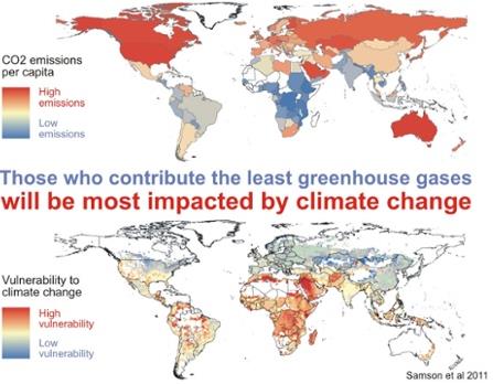
Why Climate Change Affects Poor Neighborhoods The Most.
Those who have the least will be the first to suffer the impacts of a
rapidly changing climate, worldwide. Here's an excerpt from
Time Magazine: "
Scientists frequently tout new evidence that climate change will drive some of the most populated cities in the United States underwater.
New York, Boston and Miami are all at risk. But the impact of climate
change varies even within cities, putting residents of poor
neighborhoods at greatest risk of suffering from heat-related ailments,
researchers say..."
NASA Explains How Climate Change Is Like The Flu. It's
an analogy I use often when I speak in public about climate change.
When's the last time you were 2-3 degrees warmer - how did you feel?
Chances are there were symptoms to go with the low-grade fever: chills, a
cough, maybe a rash or sniffles. We are experiencing the symptoms of a
warmer atmosphere - it's showing up in the weather. Here's a clip from
National Journal: "
For
NASA, climate change is kind of like flu season. In a new animated
video, the space agency calls the warming phenomenon "planetary fever."
Just as the human body heats up in response to an infection or illness,
Earth has warmed from the accumulation of greenhouse gases such as
carbon dioxide in its atmosphere. The average temperature of the planet
has increased more than 1 degree Fahrenheit in the last century, according to NOAA's National Climatic Data Center, which tracks global temperatures..."
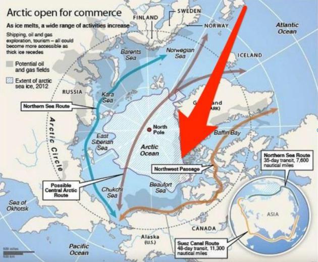
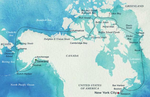
A Cargo Ship Just Completed A Historic Trip Through The Northwest Passage. Business Insider
has the eye-opening story; here's the introduction: "The hazardous
Northwest Passage is open for business. The MV Nunavik left Canada’s
Deception Bay on September 19 and rounded Alaska’s Point Barrow on
Tuesday – without an icebreaker escort. Owned by shipping firm Fednav
and built in Japan, the Nunavik is the first cargo ship to make the trip
unassisted, although technically, she is rated as a Polar Class 4
vessel, and can withstand year-round operations in first-year ice..."
Map credit above: "
The ship's route through the Northwest Passage." CNA.
Travel Scene: Global Warming Opens Northwest Passage to Pleasure Cruises.
If anyone onboard is sober enough to pay attention they might be a
little distressed at the ability to cruise NORTH of Canada, but maybe
that's just me. Keep the champagne flowing. Here's an excerpt from PostBulletin.com: "Global
warming and the resultant melting of parts of the Arctic icecap have
opened a new world of travel — a 900-mile, 32-day luxury cruise with
fares starting at $20,000.
Crystal Cruises, one of the world's top-rated cruise lines, has
announced that one of its ships, the Crystal Serenety, will traverse the
fabled Northwest Passage on this Pacific-to-Atlantic voyage, beginning from Seward, Alaska, through the north part of mainland Canada and the Arctic Ocean to New York City..."
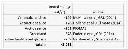
Earth Losing A Trillion Tons of Ice A Year.
Antarctic sea ice may be increasing (due to ocean warming and changes
in wind circulations in the Southern Hemisphere) but it's not close to
making up for ice loss in the Arctic and Greenland, according to this
post at Quark Soup by David Appell; here are a few excerpts: "At Slate, Phil Plait notes a new paper
that finds the Antartic is losing 159 gigatonnes of land ice a year.
How does that compare to the increase in Antarctic sea ice, a favorite talking point
of [fake] skeptics?...So unless the frozen bus stop puddles of the
world are gaining over a 1,000 gigatonnes of ice a year -- doubtful even
in Canada -- the world is definitely losing a lot of ice. And
Greenland's loss is accelerating..."
Global Warming: A Battle For Evangelical Christian Hearts and Minds.
I talk frequently in public about Creation Care and stewardship - we
are called to care for God's Creation, and that means not shrugging your
shoulders and lapsing into conspiracy theories when the subject of
environmental responsibility to future generations comes up. Here's an
excerpt from
The Guardian: "...
Many
evangelical Christians recognize this moral angle of human-caused
climate change, and also view the issue as one of stewardship of the
Earth. For example, climate scientist Katharine Hayhoe is an evangelical Christian herself, and often speaks to like-minded groups. She recently did an interview with Bill Moyers that’s well worth watching. Hayhoe told me,
The
foundation of the Christian faith is about loving others as Christ
loved us, and it is clear from the work that I do myself as well as I
see from other colleagues that those with the least resources to adapt
to a changing climate will be most affected by our actions.
Map credit above:
Top frame: national per capita carbon pollution emissions. Bottom frame: Vulnerability Index from Samson et al. (2011). Source: Skeptical Science.
Explaining Extreme Events of 2013: Limitations of the BAMS Report.
Greg Laden has perspective on attribution and causation, taking a
closer look at a recent BAMS (Bulletin of the American Meteorological
Society) report linking climate change to 9 of 16 global weather
extremes last year. Here's an excerpt at scienceblogs.com: "...There
was a pattern in the results. The studies looking at heat all suggested
a link to anthropogenic global warming (AGW). This is not surprising
because AGW has involved a global increase in average temperature which
is manifest across a variable climate, so even a modest increase in
global temperature, bunched up in to places that are a bit cooler or
warmer than average (at a given moment in time) is going to be blatantly
obvious when picking out heat events. Some of the studies that looked
at the California drought and drought in New Zealand attributed these
conditions to climate change, others were more ambiguous or suggested
that there was no link. All of the studies that looked at extreme
precipitation events concluded that there was no way to make a
connection, except one (in Northern India) which as ambiguous..."
If A Tree Falls In The Forest, But No Scientist Says So... Dr. Michael Mann at Penn State has an article at
Huffington Post,
talking about climate change impacts on major global weather events,
including the perpetual, ongoing drought gripping California. Is there a
link? Here's an excerpt: "...
The California drought is of particular interest since it is both an unprecedented and absolutely devastating ongoing event.
The thread potentially connecting that event to climate change is the
unusual atmospheric pattern that prevailed during winter 2013/2014. That
pattern was associated with a persistent "ridge" of high pressure over
the western U.S. (see my previous Huffington Post
piece) that caused the jet stream to plunge southward over the central
U.S., chilling the eastern third of the country, and to veer northward
over the west coast, pushing the warm moist subtropical Pacific air
masses that would normally deliver plentiful rainfall (and snowpack) to
California well to the north, resulting in bone-dry conditions in
California and balmy weather in Alaska. In fact, there are at least
three different mechanisms that are potentially relevant to the
connection between the 2013/2014 California drought and human-caused
climate change..."
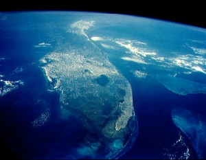
South Florida at Forefront of Climate Planning, Top U.S. Scientist Says. Here's an excerpt from a story at
The Miami Herald: "...
In
his address, Holdren ran down a laundry list of climate-related risks
from rising temperatures to worsening storms. Sitting just feet above
sea level, South Florida is particularly vulnerable to both flooding and
saltwater tainting water supplies. Because porous limestone lies under
Florida, controlling water can be tricky, Tommy Strowd, director of
operations for the Lake Worth Drainage District and a former deputy
director at the South Florida Water Management District, told the group.
The system of canals and flood control structures built a half century
ago to drain the Everglades that covered much of South Florida only made
matters worse..."


No comments:
Post a Comment