Migratory Mishaps
By Todd Nelson
I had one of the worst driving trips along Minnesota's North Shore this weekend. While the fall colors where a treat to look at, I couldn't help but notice how many small birds were being hit by cars. It seemed as though these small warbler, wren-like birds were sure having a tough time combating the gusty winds on Saturday. My only thought is that they were so tired out from the wind and potential migration that they were unable to dodge oncoming traffic. The drive switched from enjoyable to somber as we noticed more and more small birds on the side of the road... anybody have any ideas on what was going on here?
A low pressure system in the upper levels of the atmosphere will continue to wobble south of the Hudson Bay. The result will be cooler than normal conditions through much of the week as a few spotty showers sag south of the international border.
The good news is that we should avoid any mention of that dirty four-letter 'S' word in the near future except across the extreme northern part of the state early this week.
Model runs suggest a slight warm up by early next week, however I'm going to keep my crockpot warmed up for the next inevitable cold snap.
================
SUNDAY NIGHT: Partly cloudy and chilly. Patchy frost possible, mainly northern. MN Low: 36
MONDAY: Breezy and cool with spotty PM showers. High: 55
MONDAY NIGHT: Mostly cloudy. Still chilly, but not as cold. Low: 39
TUESDAY: Cool. More clouds than sun. High: 59
WEDNESDAY: Intervals of sun, winds ease. Wake-up: 40. High: 55
THURSDAY: Blue sky, mosquito-free! Wake-up: 39. High: 58
FRIDAY: Good day for a bowl of chili. Wake-up: 41. High: 58
SATURDAY: Clouds increase, showers overnight. Wake-up: 39. High: 60
SUNDAY: Gray skies and damp. Wake-up: 44. High: 60.
================
This Day in Weather History
October 6th
1997: Hail, wind, and an F0 tornado was reported in the early morning hours in several counties in west central Minnesota. Near Canby in Yellow Medicine County, hail combined with wind gusts nearing 60 mph damaged the roof of bus garage, elementary school windows and a school vehicle. Renville, McLeod, Carver, Scott, and Dakota counties also received hail and strong winds. Widespread pea to marble size hail accumulated to three inches deep in several areas, and severely damaged crops over a large part of Renville county. Also, power lines and trees were blown down. Southeast of Bird Island, a barn collapsed and killed over 100 pigs. Near Brownton in McLeod County, hail accumulated to a depth of 3 inches with one foot drifts. A brief tornado touched down near Stewart in McLeod County, damaging a few trees.
1987: Snow falls over Arrowhead region
=================
Average High/Low for Minneapolis
October 6th
Average High: 63F (Record 87 set in 2007)
Average Low: 43F (Record 25 set in 1873)
=================
Sunrise/Sunset Times for Minneapolis
October 6th
Sunrise: 7:37am
Sunset: 6:44pm
================
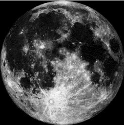
Moon Phase for October 6th at Midnight
1.2 Days until Full Hunters' Moon
=====================
2nd Week of October
From the Freshwater Society
Brussels sprouts, broccoli, cabbage, cauliflower and leaf lettuce keep on growing in cool weather. There is still time to plant daffodil, tulip and crocus bulbs in gardens for next spring. American robins, red-winged blackbirds and common grackles are seen in their big flocks. Other migrants moving through include fox, white-throated and white-crowned kinglets and dark-eyed juncos. In the northern part of the state, black bears usually head for their winter dens between Sept. 24 and Oct. 24.

======================
Bird Migration Misfortune ??
I had one of the worst experiences driving along MN's North Shore this weekend. While the fall colors are stunning right now, I couldn't help but notice how many small birds were being hit by cars along highway 61. It was unavoidable... These small birds would fly out from along the roadside grass and smack into your car. I would have to say that I even hit a handfull of small birds. At one point, we counted more than 30 small dead birds on the road from Split Rock Lighthouse to Silver Bay. Yes, it was breezy on Saturday and I noticed that several of these small birds were having a tough time in the wind. The only thing that I can think of is that they may be migrating right now and are possibly tired. With the combination of that and the strong wind, there were unable to quickly dash away from oncoming vehichles. Does anyone have any idea of what could be going on here? I would have to say there were several different kinds of birds that were hit, but the majority of them looked like the Yellow-Rumped Warbler ??
(Photo Credit: Dan Pancamo via WikiPedia)

==========================
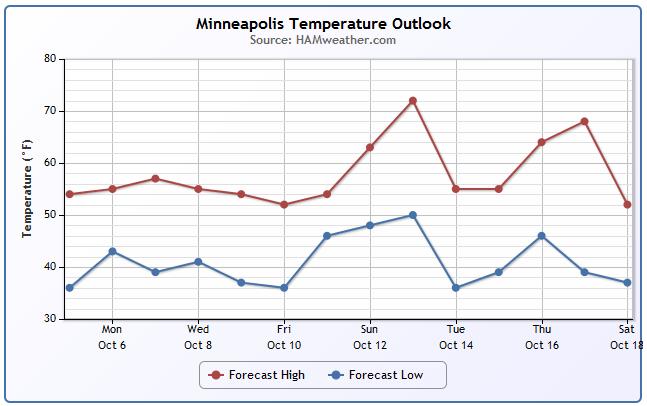
Minneapolis Temperature Trend
Temperatures will remain below average through the week ahead, but we'll see gradually warming temperatures through mid October. This is the time of year when big temperature swings ahead of and behind storm systems can be quite rapid and extreme.
=========================
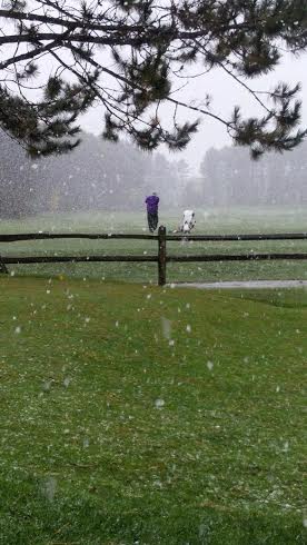
The Definition of Insanity of Hardcore?
That was the post from @CloquetCC on Friday when snow was falling across parts of the state.
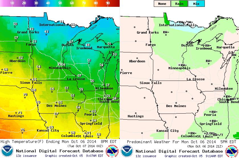
Monday Weather Outlook
Chilly weather conditions will persist on Monday with a few lingering showers across the northern part of the state. It could be cold enough fro a few light snow showers to mix in across the extreme northern part of the state.
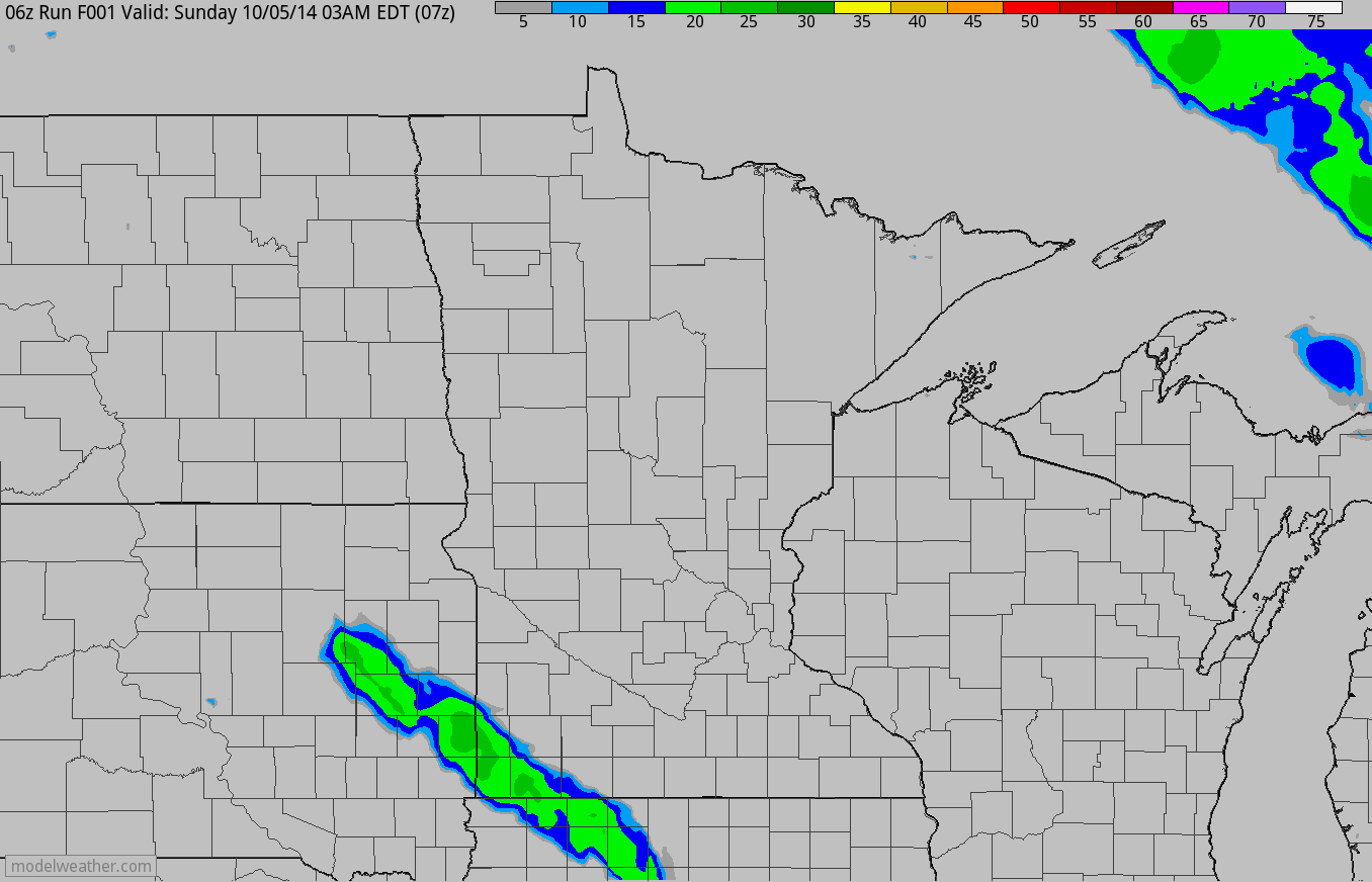
Simulated Radar Reflectivity
An are of low pressure in the upper levels of the atmosphere will continue to spin on the southern flank of the Hudson Bay. The counter-clockwise rotation will keep weather conditions unsettled over the next several days. There will be spotty showers rolling in from the north through early next week.
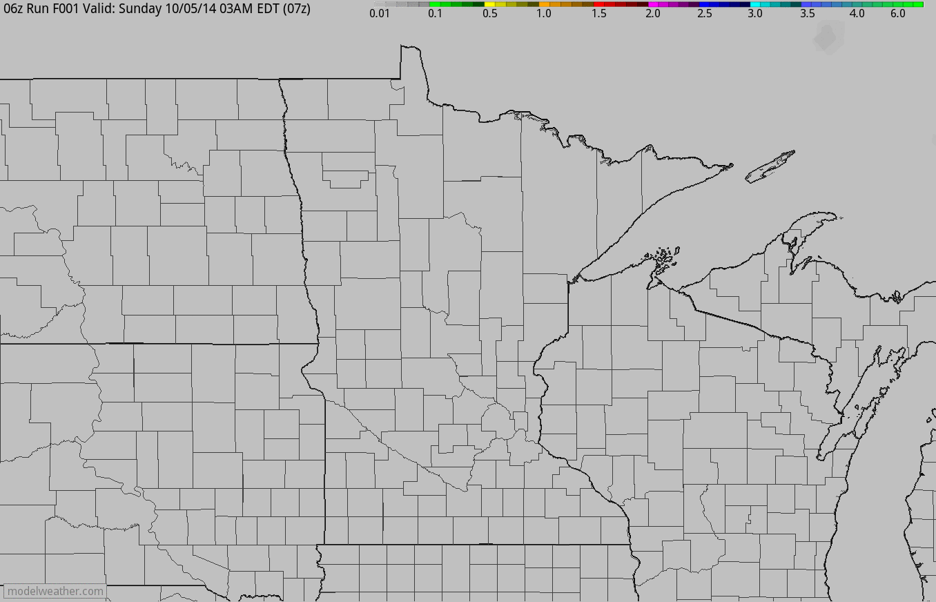
Simulated Rainfall Accumulation
While it'll continue to stay unsettled, precipitation amounts don't look to be too widespread or heavy through the early week time frame.
Upper Level Low
The upper level low spinning around the southern flank of the Hudson Bay will be nearly stationary until later this week. This will keep cool weather conditions in place over the next several days
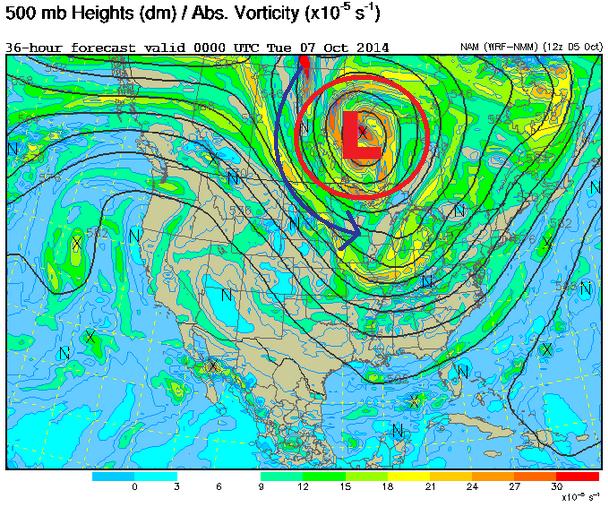
Weather Outlook
Here's another view of the upper level low... note how the low wobbles north of us through early this week. This will continue to send cooler than normal conditions south of the border with a few passing showers.
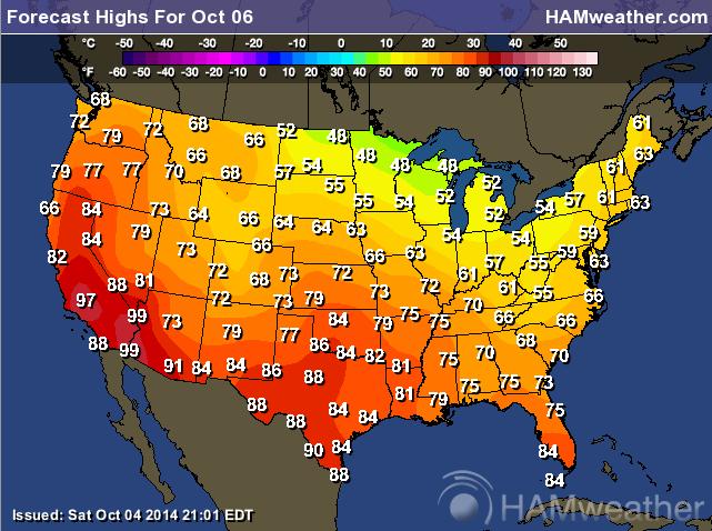
Monday Temperatures
A high amplitude weather pattern is having big impacts on temperatures across the country. A ridge of high pressure in the western U.S. will keep temperatures warmer while a trough of low pressure in the eastern part of the country will keep temperatures cooler than average.
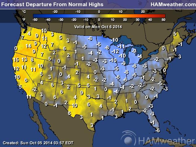
Highs From Normal Monday
Here's a look at high much above and below average high temperatures will be on Monday across the country. Some of the coldest temperatures will be found in the Midwest/Great Lakes Region, while some of the warmest temperatures will be found across the western part of the country.
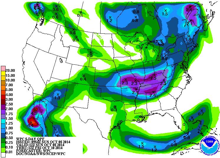
Precipitation Outlook
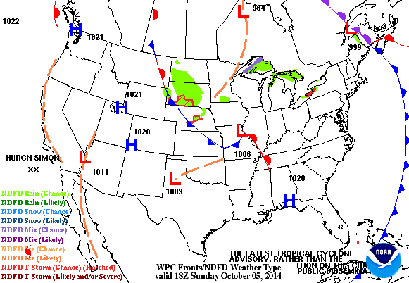
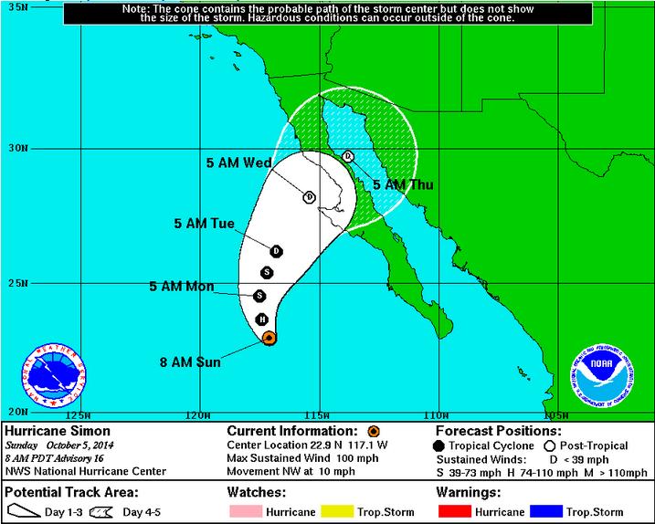
According to NOAA's HPC, the 5 day rainfall forecast suggests heavier rainfall potential from the Middle Mississippi Valley to the Ohio and Tennessee Valley. Interestingly, this moisture is showing up on the southern flank of the trough of low pressure in the eastern half of the country. The base of the low pressure is where upper level winds tend to be stronger and is also an area in which storm systems are pushed through the atmosphere. Also note the precipitation near Baja California and the Desert Southwest, this is from Hurricane Simon in the Eastern Pacific.
Hurricane Simon
Hurricane Simon is the 18th named storm of the 2014 Eastern Pacific Hurricane Season. This season has been significantly more active than the Atlantic Hurricane Season. The Atlantic Hurricane Season has only hosted 5 named storms this season.
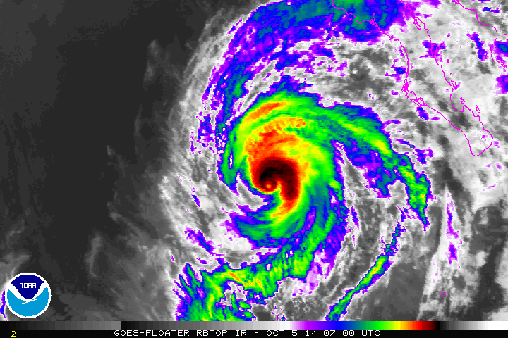
Tracking Simon
Simon will lose strength heading into the week ahead. Tropical Depression strength is expected by the time Simon makes its way toward Baja California by midweek.
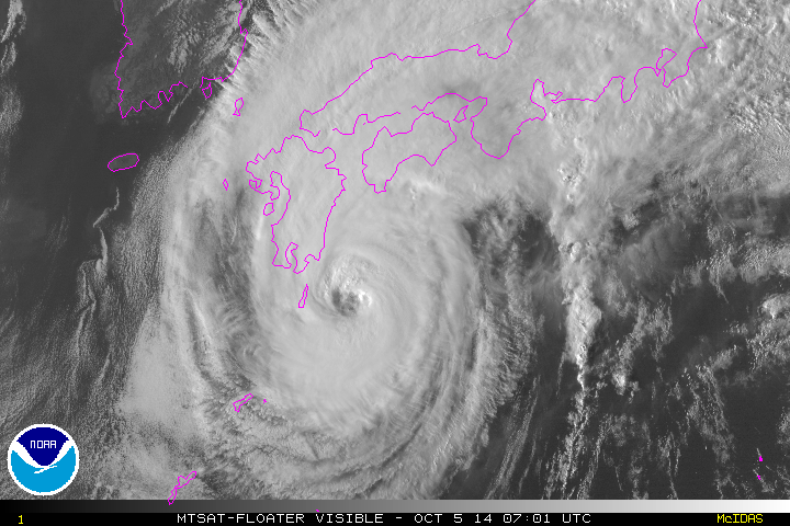
Typhoon Phanfone
By comparison, typhoon Phanfone has been churning up the western Pacific waters over the past couple of days. Phanfone is expected to brush Japan through early this week.
Thanks for checking in and have a great week ahead! Don't forget to follow me on Twitter @TNelsonWX

No comments:
Post a Comment