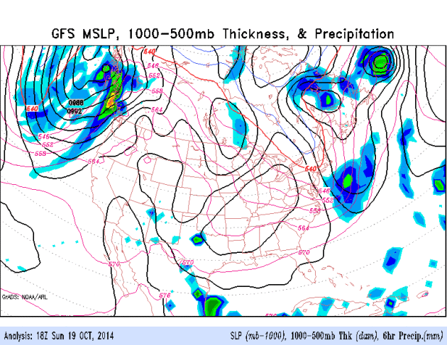
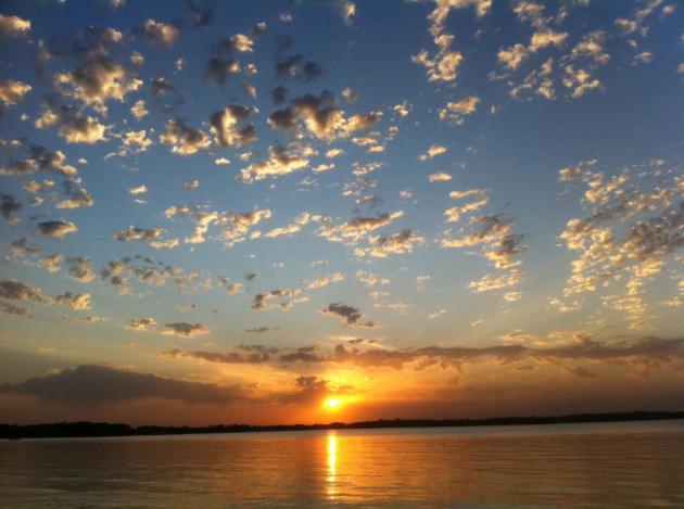
69 F. high in the Twin Cities Sunday.
57 F. average high on October 19.
49 F. high on October 19, 2013.
October 19 in MInnesota Weather History:
2002:
Heavy snow across central Minnesota. It fell in a 10-20 mile wide band
from southeast North Dakota to around Grantsburg Wisconsin. Little Falls
picked up nine inches.
1916:
Snow fell in south central Minnesota with 4.5 inches recorded in New
Ulm, 4 inches in Farmington and Hutchinson, 3.5 inches in Montevideo,
and 3 inches in Faribault.
1835: 6 inches of snow fell at Ft. Snelling.
Analog Method
How
can you get a slight edge on predicting the winter to come? Nutty
squirrels? Colorful caterpillars? Aunt Mabel's annoying bursitis? An
analog forecast looks at previous years when weather was vaguely
similar. "The maps are similar to 2006 and here's what happened that
winter". It's a start, but every pattern is slightly different.
We
factor everything from ocean water temperatures to melting arctic ice,
looking at blocking patterns with acronyms like PDO, NAO & AO. And
we wait for a sustained El Nino warming signal to finally kick in over
the Pacific, which tends to keep much of the USA downwind a bit milder;
wetter and stormier from the Gulf to the East Coast.
The last 2
winters brought more than 67 inches of snow in the metro. 3 years ago: a
paltry 22.3 inches. My hunch? We wind up with average snowfall (in the
50s) with fewer subzero attacks - a bargain compared to last winter.
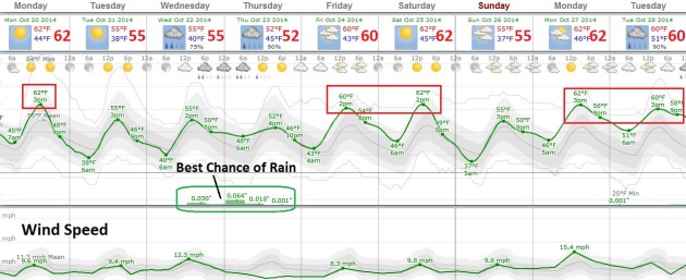
Showers
don't return until late Wednesday and Thursday; otherwise a bloated
ridge of high pressure treats us to Indian Summer into much of next
week. 5-6 more days above 60F, maybe a day above 70F next week?
With all the bad news floating around I'm happy the weather is cutting us a break.
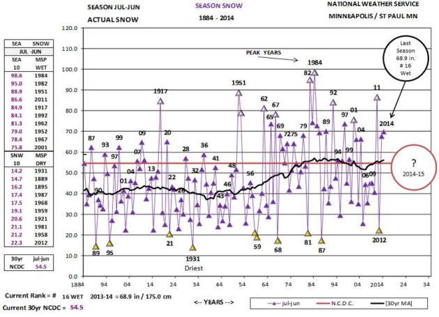
MSP Snowfall Trends.
The graph above shows seasonal snowfall for the Twin Cities since 1883;
a slight uptick in amounts since the 1950s, but considerably more
volatility too, greater swings and extremes since the early 80s. Go
ahead, flip a coin. Chance are it won't be "average". Graphic:
Twin Cities National Weather Service.
Skipping Into November.
Nothing ominous (or tragic) showing up on the weather maps looking out 2
weeks or so. A longwave ridge remains over the Rockies and Plains,
meaning a milder bias into early November. The best chance of rain comes
late Wednesday into Thursday, otherwise sunshine is the rule.
 New England Nor'Easter - Heavy Rain Lashes Pacific Northest
.
GFS data also shows possible tropical development over the Gulf of
Mexico by Saturday, possibly brushing south Florida before pushing into
the Atlantic. Relatively warm weather lingers from southern California
into the Plains and Mid South. Loop: NOAA.
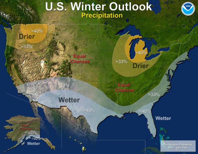
Winter Precipitation Trends.
The map above shows NOAA's winter overview: drier for the Pacific
Northwest and Great Lakes; El Nino creating a split jet stream flow that
tends to keep the southern USA and East Coast wetter.
NOAA adds: "
Last
year’s winter was exceptionally cold and snowy across most of the
United States, east of the Rockies. A repeat of this extreme pattern is
unlikely this year, although the Outlook does favor below-average
temperatures in the south-central and southeastern states..."
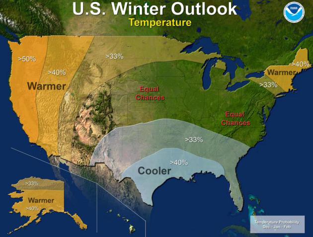
December - February Temperatures.
A few private forecasting firms are still predicting another bitter
"Polar Vortex 2" winter, but I'll be amazed if we fall into the exact
same block that set up last winter. Yes, there was early snow coverage
across Siberia (sometimes a cue of harsh winters to come downstream over
North America) and persistent ridging continues in the Gulf of Alaska,
which may eventually turn on a northwesterly flow aloft east of the
Rockies. That said, I still think we'll see more of a zonal influence
over the central USA, with or without El Nino kicking in.
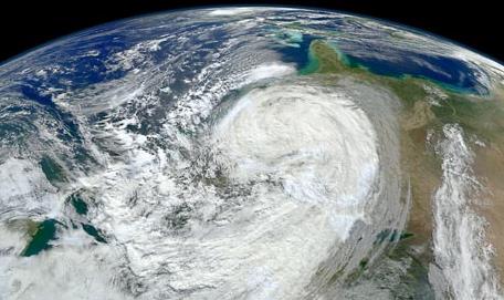
Two Years After Hurricane Sandy Hit The U.S. What Lessons Can We Learn From The Deadly Storm? National Geographic poses the question, taking another look at Superstorm Sandy; here's a clip: "...
In
the case of Sandy, the European model was the outlier for days. The
great irony with Sandy was that it went exactly where the European model
said it was going to go. All the other models, including the ones the
National Hurricane Center has come to regard as very reliable, were
consistently saying, No, the storm is going to go out to sea. It really
wasn't until the 25th of October, just four days before the storm made
landfall, that the other models started to join the European model in
saying that it was going to make this crazy arc into land..." (Sandy image: NASA).
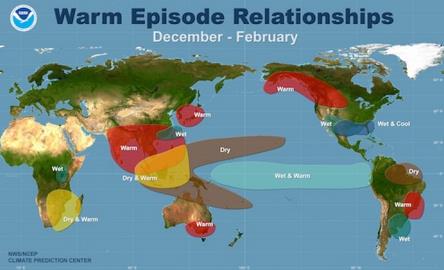
Where Is El Nino? Why Do We Care? Climate Central
explains the correlations between El Nino warm phases and weather
downwiind across the USA. Although it turns out every El Nino is a bit
different; here's an excerpt: "
That El Niño we’ve been tracking for months on end — the one that is taking its sweet time to form — still hasn’t emerged, forecasters announced Thursday. But
the reason we still care so much about it, following all of its tiny
fluctuations toward becoming a full-blown El Niño, is that it can have important effects on the world’s weather,
including in the U.S. It can even boost global temperatures, helping
set the planet on the course to be the warmest year on record..."
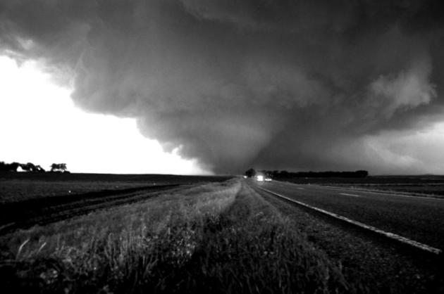
Tornado "Clusters". It's A Thing.
USA TODAY has a good summary of a new paper showing recent tornado trends; here's an excerpt: "...
Now,
on the days when tornadoes do occur, the twisters happen in greater
number, according to the study published by NOAA researchers in the
journal Science. For example, in the 1970s,
there were only about 0.6 days a year on which more than 30 tornadoes
were spotted. But that leaped to about three days per year in the 2000s.
"There is a lower probability of a day having a tornado, but if a day
does have a tornado, there is a much higher chance of having many
tornadoes," the study found..."
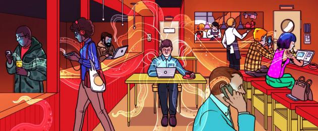
Why I'll Think Twice Before Using A Public WiFi Network.
At least one that isn't encrypted. Medium dives into the deep end of
the pool describing, in vivid real-world details, how your personal
information is put at risk in many public WiFi networks; here's a clip:
"...
The idea that public WiFi networks are not secure is not exactly
news. It is, however, news that can’t be repeated often enough. There
are currently more than 1.43 billion smartphone users worldwide and more than 150 million smartphone owners in the U.S. More than 92 million American adults own a tablet and more than 155 million
own a laptop. Each year the worldwide demand for more laptops and
tablets increases. In 2013, an estimated 206 million tablets and 180
million laptops were sold worldwide. Probably everyone with a portable
device has once been connected to a public WiFi network: while having a
coffee, on the train, or at a hotel..."
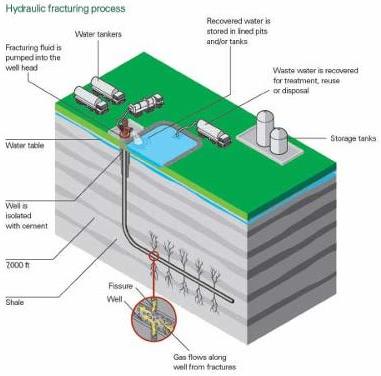
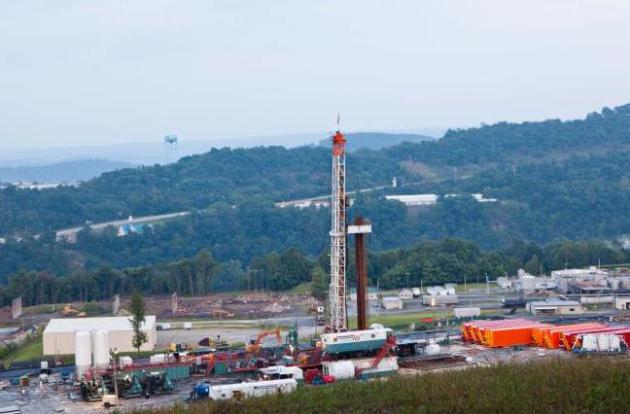
Fracking To Make U.S. "Energy Superpower". Saudi Gazette
has the story. What, you don't find time to read Saudi Gazette on a
regular basis? What's wrong with you! Here's an excerpt: "...
Surging
shale output has put the United States on track to pass Russia and
Saudi Arabia as the world's largest producer of crude oil and to become a
major exporter of natural gas. The Environmental Protection Agency is
working to cut carbon emissions from the country's largest source, power
plants. Still, green groups warn that those gains could vanish without
reductions in methane emissions from oil and gas production.
Environmentalists have urged the EPA to issue mandatory curbs on the
industry's emissions of the potent greenhouse gas..."
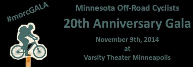
20th Anniversary Gala for MORC.
MORC is a non-profit organization dedicated to "gaining and maintaining
trails" since 1994. These are off-road mountain and bmx bike trails for
all ages to enjoy around the Twin Cities metro. With 2014 being our
20th anniversary as a non-profit we are celebrating by throwing a BIG
party! The Minnesota Off-Road Cyclists are hosting the
20th Anniversary Gala Sunday, November 9th from
2-7 pm at the
Varsity Theater. This event
will be aimed at raising funds for our 2015 season. We are currently
developing the Three Rivers Park area at Lake Rebecca as well as new
trail at Theodore Wirth Park. Developing these new trails will take a
lot of blood, sweat, tears and dollars to complete but it is sure to be
amazing!
This will be a black tie dinner event that includes guest
speakers; Paul Douglas, local meteorologist, Steve Flagg (President
QBP), Matt Andrews (International Mountain Bicycling Association) and
Libby Hurley (MN High School Mountain Bike League) as well as live and
silent auctions to support MORC’s efforts moving forward. Also excited
to announce "The Lost Wheels" providing live musical entertainment for
the evening!
Tickets are now on sale here:
bit.ly/morcGALA
TODAY: Plenty of sun, cool breeze. Winds: NW 15. High: 60
MONDAY NIGHT Clear and cool. Low: 39
TUESDAY: Blue sky, still pleasant. High: 59
WEDNESDAY: Clouds increase, PM showers. Wake-up: 41. High: near 60
THURSDAY: Showers slowly taper, cool and damp. Wake-up: 48. High: 57
FRIDAY: More mild sunshine. Wake-up: 44. High: 63
SATURDAY: Sunny, still spectacular. Wake-up: 47. High: 64
SUNDAY: Weather on hold. Sunny, less wind, a bit cooler. Wake-up: 39. High: 60
Climate Stories...
In The Midwest, In The World, The Only Doubt Is In Our Minds. Here's a snippet from a story at
The Fort Wayne Journal Gazette:
"...But one finding during the national and international studies of
the past few years surprised even the scientists. “We're seeing strong
trends in extreme events,” Wuebbles said. “We expected to see an
increasing trend for heat waves and generally a decreasing trend for
cold waves. “But what we didn't realize, and we should have, is that
more precipitation is coming in larger events – a very clear trend
that's occurring, particularly here in the Midwest..."
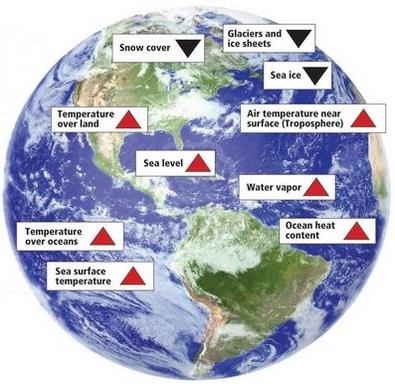
Image credit above: "
These
are just some of the indicators measured globally over many decades
that show the earth's climate is warming. Red arrows indicate increacing
trends, blaok arrows indicate decreasing trends. All the indicators
expected to increase in a warming world are increasing, and all those
expected to decrease in a warming world are decreasing."
Second Annual Minnesota Climate Adaptation Conference. Tickets are still available
for the November 6, 2014 conference at the Hyatt in Minneapolis. Last
year's conference was eye-opening with useful, actionable information
across multiple industries and agricultural concerns. Here's a draft
agenda and overview of what to expect this year: "
The 2014
Conference on Climate Adaptation is designed for local officials,
planners, engineers, natural resource practitioners and others who want
to know more about climate adaptation strategies. Learn about new plans
that have been implemented or tested in various sectors, including human
health, local governmental entities, college campuses, resources,
recreation, and agriculture. Discover ways in which individual action
could impact climate change. Our keynote speakers will provide updates
on the increasing number of severe storm events, with continuing
discussion in breakout sessions in the morning and afternoon.
Registration is 95.00, which includes lunch, breaks and parking."
Barrow's Dramatic Autumn Warming Linked to Sea Ice Shrinkage. Here's an excerpt of a story at
Alaska Dispatch that got my attention: "...
While average annual temperatures in Barrow
increased by 2.7 degrees Celsius (4.86 Fahrenheit) from 1979 to 2012,
October temperatures rose by a whopping 7.2 degrees (12.96 Fahrenheit)
over that period, according to the study, published in the Open Atmospheric Science Journal. “I was actually astonished about it,” said Gerd Wendler,
lead author and a professor emeritus at the Arctic Climate Research
Center, part of UAF’s Geophysical Institute. “I think I have never,
anywhere, seen such a large increase in temperature over such a short
period...”
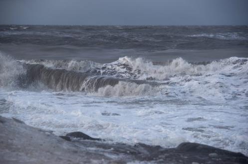
Photo credit above: "
Chukchi Sea waves crash on the coast at Barrow on Sunday, Nov. 10, 2013." Marc Lester / ADN archive.
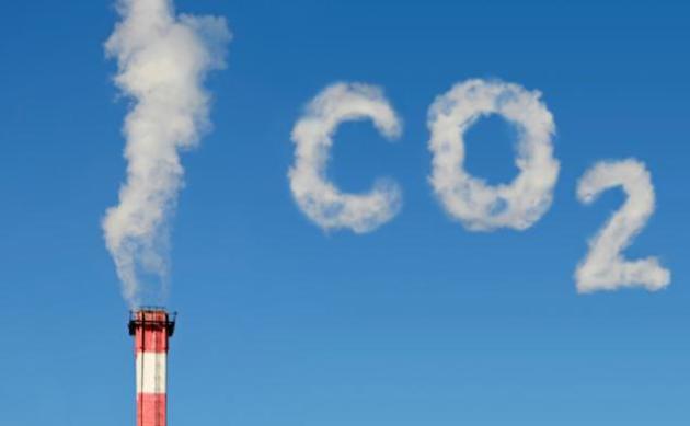
Study: Natural Gas Surge Won't Slow Global Warming. US News has a summary of recent research findings; here's a snippet: "...
Computer
simulations show that emissions of heat-trapping gases to make
electricity would not decline worldwide and could possibly go up, says
the study, released Wednesday by the journal Nature. Unconventional
techniques such as high-volume hydraulic fracturing and ultra-deep water
drilling have increased global supplies of natural gas so much that
prices are now expected to remain relatively low for years to come. That
makes generating electricity with natural gas cheaper than it otherwise
would be, and makes it harder for wind and solar to compete..."
File Image Credit: "
In
this Aug. 6, 2011 file photo, a natural gas well operated by Northeast
Natural Energy is seen in Morgantown, W.Va. Cheap and plentiful natural
gas isn’t quite a bridge to a brighter energy future as claimed and
won’t slow global warming, a new study projects. Abundant natural gas in
the United States has been displacing coal, which produces more of the
chief global warming gas carbon dioxide. But the new international study
says an expansion of natural gas use by 2050 would also keep other
energy-producing technologies like wind, solar and nuclear, from being
used more. And those technologies are even better than natural gas for
avoiding global warming." (AP Photo/David Smith)
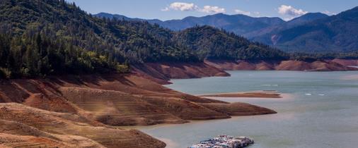
When Our Responses to Drought Make Things Worse. Here's a clip from Peter Gleick writing for
Huffington Post: "...
In a new study just published by the journal Sustainability Science (Springer), analysis from the Pacific Institute
shows that many of the fundamental responses of California water users
to severe drought actually make the state's overall water conditions
worse -- that in the end, many of these actions are "maladaptations."
Water is a complex resource; and water problems are an equally complex
mix of natural resource, technology, social, economic and political
conditions. When water is limited, such as in water-short areas or
during extreme events such as droughts, society puts in place a variety
of responses..."
Churches Go Green By Shedding Fossil Fuel Holdings. Here's an excerpt from a story at
The New York Times: "...
But
churches can lend a powerful moral sway to the movement, said Marion
Maddox, an expert in religion and politics at Macquarie University in
Australia. “The amount of money we’re talking about isn’t going to
bankrupt any fossil fuel companies,” Dr. Maddox said. Divestment by the
churches, however, “has the effect of getting people to stop and think,
‘Is this respectable to be involved with?’ .
No comments:
Post a Comment