Helicopter Parents
By Paul Douglas
Parenting: the most important job on the planet. And the only one that doesn't come with a training manual.
There's a lot of digital angst out there today. How much play time on smart phones, tablets and apps is too much? "Step away from the device!"
My youngest son loved video games, especially aviation-related simulations. Today he flies Navy MH-60R Seahawk helicopters for a living. "Dad, you may think I'm nuts but playing those games helped with with my fine motor skills, hand-eye coordination and multitasking. It prepared me for this challenge" he assured me. We didn't see that coming, but it did help our parental guilt pangs.
This is about as cool as it gets looking out 1-2 weeks. The weather models I study (and trust to some degree) maintain a big long wave ridge of high pressure over the Rockies and Plains, diverting the core of the jet stream to our north, bottling up any nasty-cold over central Canada until further notice. More 60s are on tap tomorrow, and by late next week another 70-degree high is likely. Odds favor 50s for Halloween; any true cold pangs pushed deeper into November. An omen? We'll see, but I suspect this winter won't look anything like last.
===============
FRIDAY NIGHT: Still cloudy and breezy. Low: 40
SATURDAY: More sun, less wind. Brisk. High: 53
SATURDAY NIGHT: Clear, cool and quiet. Low: 38
SUNDAY: Some sun, warmer breeze. High: 64
MONDAY: Blue sky, a bit cooler. Wake-up: 43. High: 58.
TUESDAY: Sunny and pleasant. Wake-up: 40. High: 59
WEDNESDAY: Partly sunny, touch of September. Wake-up: 39. High: 62
THURSDAY: Mix of clouds and sun, still quiet. Wake-up: 48. High: 64
FRIDAY: OMG. More Indian Summer. Wake-up: 49. High: 70.
=================
This Day in Weather History
October 18th
1950: Record high temperatures were set across the area as highs reached the mid to upper 80s. Minneapolis and Farmington saw highs of 87 degrees Fahrenheit, while Albert Lea reached 86 degrees.
1916: Blizzard over Minnesota. Hallock's temp is in the 60's. Drops to 2 above by the 20th.
==================
Average High/Low for Minneapolis
October 18th
Average High: 57F (87F set in 1950)
Average Low: 39F (18F set in 1972)
===================
Sunrise/Sunset Times for Minneapolis
October 18th
Sunrise: 7:32am
Sunset: 6:23pm
===================
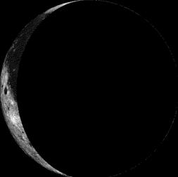
Moon Phase for October 18th at Midnight
3.5 Days After Last Quarter
====================
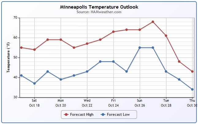
Minneapolis Temperature Trend
Looking at the temperature trend ahead, we stay a bit on the cool side this weekend and through early next week, but looking ahead to the end of next week/weekend we warm up nicely. Weather models suggest a large ridge of high pressure building in over the central U.S. which will have mostly dry and warm conditions in place for several days.
======================
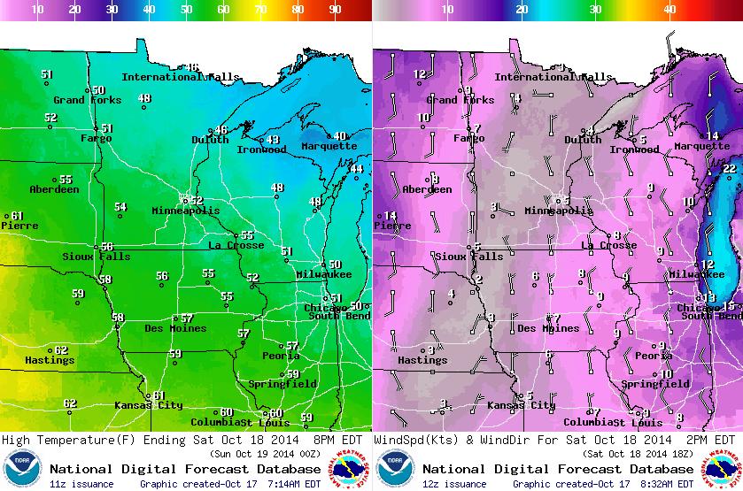
Saturday Weather Outlook
After a fairly cool and breezy Friday, weather conditions on Saturday will improve just a little. The wind won't be quite as bad, but it will still be Fall-like. Highs in the northern half of the state will be stuck in the 40s, while we'll rebound into the 50s across the southern part of the state.
National Weather Outlook
Our fast moving clipper system that brought cool and breezy conditions on Friday will continue to quickly move east over the weekend. In it's wake, a cool Canadian high pressure system will work in on Saturday and bring cool/dry weather to the Midwest. Another fast moving clipper looks to scoot through the Canadian Prairie Provinces and bring a few showers to far northern Minnesota by Sunday. Nationally, there are no big storms in the forecast in the foreseeable future.
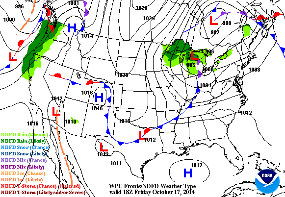
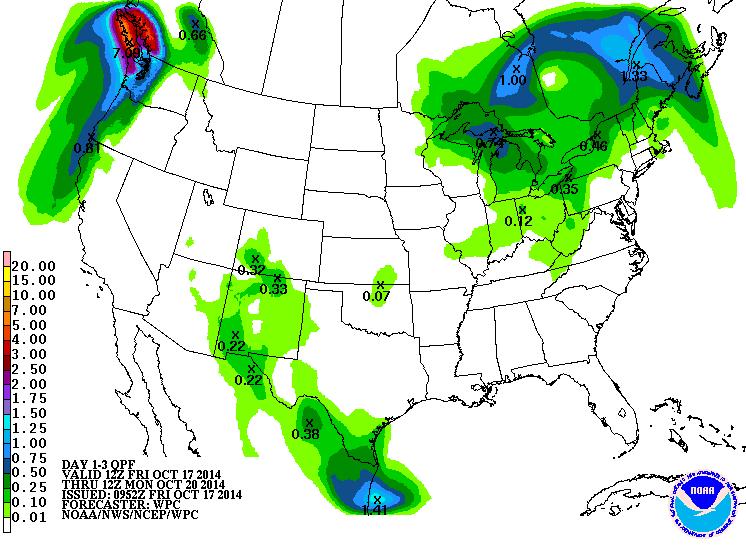
Nationally Quiet
According to NOAA's HPC, the 3 day rainfall forecast doesn't suggest much in terms of heavy rainfall potential across the Continental U.S.. We're in a fairly quiet weather patter right now with the jet stream (upper level winds) zigging and zagging from north to south across the country. This is keeping weather patterns nearly stagnant from day to day.
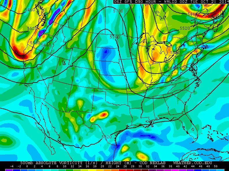
Upper Level Winds (High Amplitude)
The 500mb vorticity map by early next week shows how winds in the upper levels of the atmosphere will be positioned by then. Note the 2 prominent dips; #1 on the West Coast and #2 near the Great Lakes. These are areas of cooler, cloudier and unsettled weather, but in the middle there is a ridge of high pressure that will keep weather conditions across the Rockies/Plains States mostly dry, quiet and warmer.
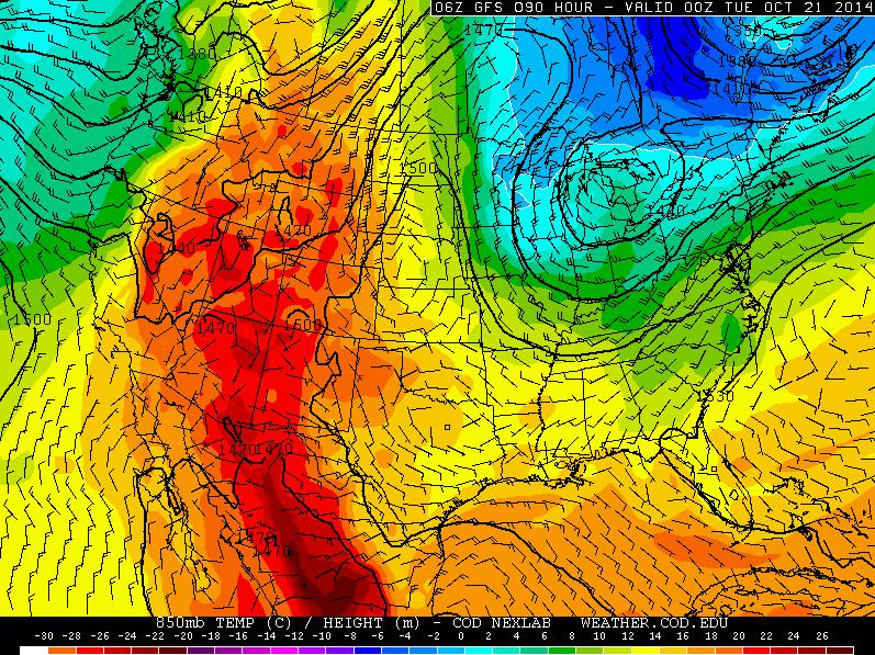
Temperature Outlook
The temperature outlook a few thousand feet off the ground (850mb) by early next week coincides with the map above (500mb vorticity chart). Note where the troughs and ridge are positioned in comparison to that of the temperature profile below. As we head into the second half of October, this ridge of warmer/drier weather looks to slowly push east and take up residence in the central U.S. by the middle/end of next week... warmer weather is once again on the way.
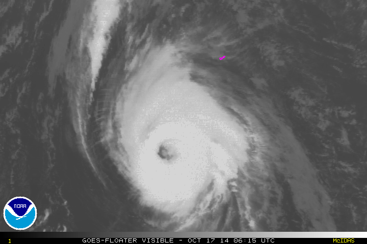
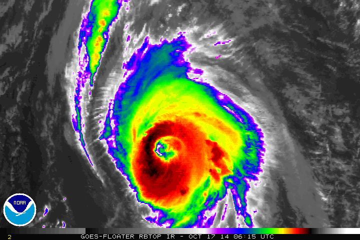
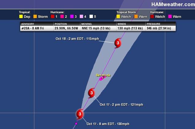
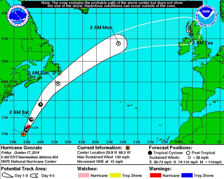
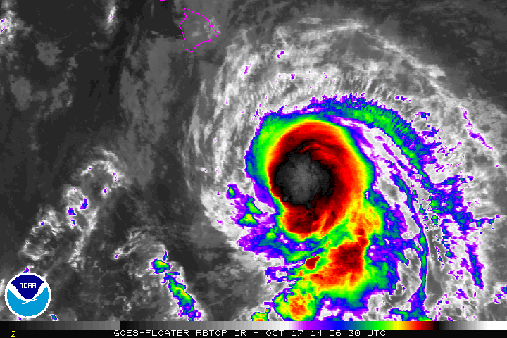
Tracking Gonzalo
Gonzalo was still a major category 3 hurricane (sustained winds of 130mph) by daybreak Friday as it loomed nearly 200 miles south of Bermuda. Gonzalo was comparable to that of Hurricane Fabian, which hit the island on August 5, 2003 with sustained winds of nearly 120mph.
Gonzalo is the only the 7th named storm of the 2014 Hurricane Season. Here were the predictions from earlier this year about the hurricane season:
"Predictions:
April 10, 2014 - Forecasters William Gray and Phil Klotzbach of Colorado State University release their 2014 hurricane season predictions: nine named storms and three hurricanes, one of them major.
May 22, 2014 - The National Oceanic and Atmospheric Administration forecasts a near-normal or below-normal hurricane season, predicting that there is a 70 percent chance of having eight to 13 named storms, of which three to six could develop into hurricanes, including one to two major hurricanes (categories 3-5)."
Read more from CNN.com HERE:
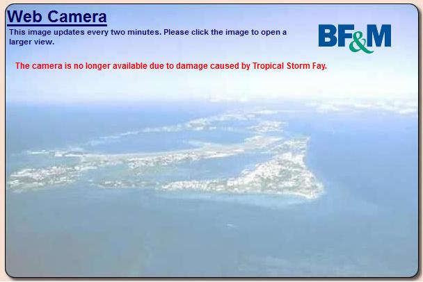
Bermuda Webcam
I wanted to add a webcam from the Bermuda Weather Service, but when I pulled it up, this is what I found! Interestingly, Tropical Storm Fay earlier in the week caused some damage on the island and the webcam wasn't working...
Tracking Gonzalo Cont.
The good news is that Gonzalo's pace will expedited by stronger upper level winds. Weather conditions will continue to improve over the weekend, so cleanup efforts on the island should be ok.
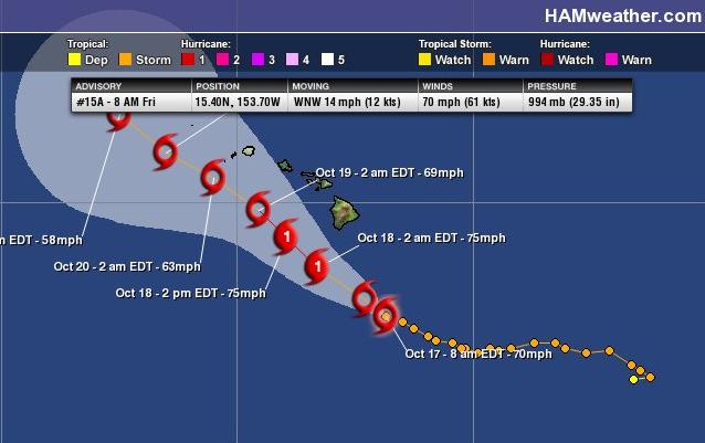
Tracking Ana in the Central Pacific
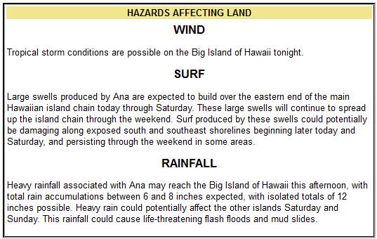
As of early Friday morning, Ana was a high end Tropical Storm with sustained winds of 70mph as it loomed off the SE coast of the Big Island of Hawaii. Tracking NW, Ana will have impacts across the entire Hawaiian Islands over the weekend.
"HONOLULU (AP) — A powerful Pacific storm predicted to grow to hurricane force churned toward Hawaii, bringing with it heavy rains and potentially destructive winds that could begin hitting the state later Friday.
Forecasters said that the storm likely will bring 40 to 50 mph winds to the Big Island's Kau, Puna and South Kona districts.
"Right now, we expect the main impacts to be on the Big Island," National Weather Service meteorologist Ray Tanabe said Thursday. The weather service has issued a tropical storm watch for the island."
Read more from HuffingtonPost.com HERE:
Tracking Ana Cont.
The track of Ana has shifted a bit south... while impacts on the island may not be quite as significant as they could have been, a potential category one storm just south of the Islands will still cause some commotion.
Strong winds, heavy rainfall and large surf will all be contributing factors to a somewhat ugly weekend in Hawaii. The Central Pacific Hurricane Center has more on the specific threats:
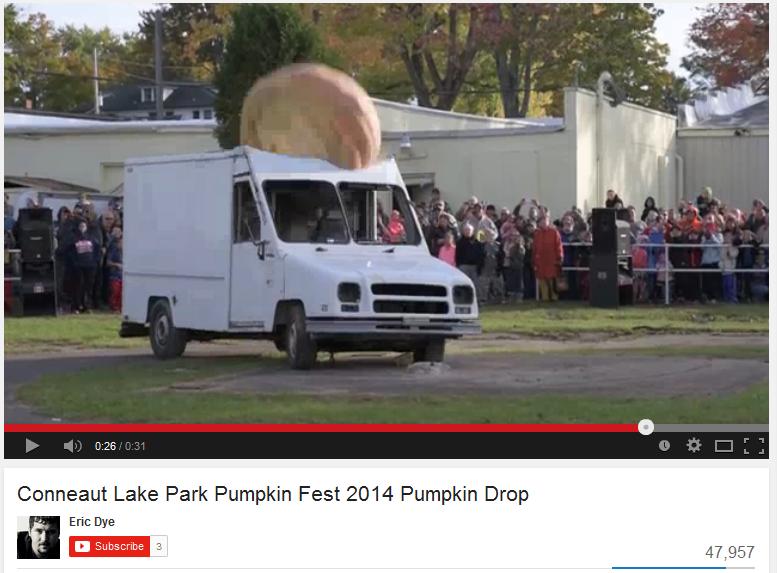
1,200 Lbs Pumpkin Drop??
And for those of you who like watching metal get crushed... how about this! It's a 1,200 Lbs. pumpkin drop onto a truck at the Conneaut Lake Park Pumpkin Fest in Pennsylvania.
Check out the video HERE:
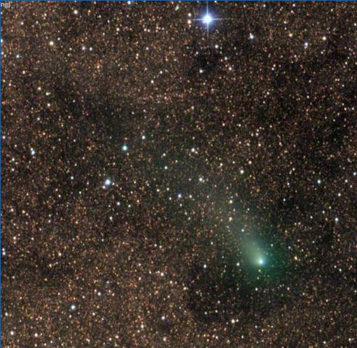
Green Comet Buzzes Red Planet
"On Sunday, Oct. 19th, Comet Siding Spring will pass only 140,000 km away from Mars. For comparison, that's about 1/3rd the distance between Earth and the Moon. For a while last year, astronomers thought the comet might actually hit Mars, setting off a cataclysmic climate change experiment, but now we know it's going to be a near miss. Last night, only three days before closest approach, astrophotographer Damian Peach snapped this picture:"
Read more from SpaceWeather.com HERE:
Thanks for checking in and have a great weekend ahead! Don't forget to follow me on Twitter @TNelsonWX

No comments:
Post a Comment