By Paul Douglas
"A lot of people like snow. I find it to be an unnecessary freezing or water" joked comedian Carl Reiner. Love it or hate it winter brings out the best in us.
Think about it. If every day was 80 degrees and sunny would we ever get anything done? Weather extremes over the millennia have forced civilizations to innovate - to tinker and engineer - trying to make us as weather-proof as possible. From stricter building codes and resilient building materials to warmer apparel and new transportation options. We bad-mouth "bad weather" but it's a powerful incentive and a force for good since the first caveman complained about the wind chill long ago.
A few tentative jabs of chilly air are on the way but nothing I'd characterize as arctic or unusual. The pattern continues to favor bitter air pouring into New England, spinning up nor'easters that will buffet big cities from D.C. to Boston. But a stubborn ridge of high pressure straddles the central USA into mid-November. A mild bias should linger close to home for the next 2 weeks; I envision a few more days above 60F. Winter is coming, but reluctantly it seems.
Remember, all that annoying cold and snow brings out our inner inventors.
===========
SUNDAY NIGHT: Slight chance of showers overnight. Low: 49
MONDAY: Peeks of sun. Stray shower early. High: 62. Winds: WNW 10-15
MONDAY NIGHT: A few more showers. Low: 41
TUESDAY: Mostly cloudy and cooler, feels like October. High: 49
WEDNESDAY: Partly sunny and brisk. Wake-up: 34. High: 49
THURSDAY: Mostly cloudy, feels like November. Wake-up: 37. High: 52
HALLOWEEN: Clear, cool and dry for Walking Dead Reunion. Wake-up: 32. High: 45
SATURDAY: Hard freeze. Bright sun and breezy. Wake-up: 28. High: 47
SUNDAY: Partly sunny, near normal. Wake-up: 35. High: 50
==============
This Day in Weather History
October 27th
1943: Said to be one of the worst fogs in the Twin Cities in memory. A very dense area of fog, with an average of 75 feet in thickness, blanketed the area. At the worst, street lights could not be seen 25 yards away. Drivers refused to cross unmarked railroad crossings and traffic was brought to a standstill.
1931: Storm hits the Duluth area. Barometer falls to 29.02.
=================
Average High/Low for Minneapolis
October 27th
Average High: 53F (Record: 74 set in 1948 & 1922)
Average Low: 36F (Record: 13 set in 1997)
================
Sunrise/Sunset Times for Minneapolis
October 27th
Sunrise: 7:44am
Sunset: 6:08pm
================
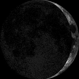
Moon Phase for October 27th at Midnight
2.8 Days Before First Quarter
=================
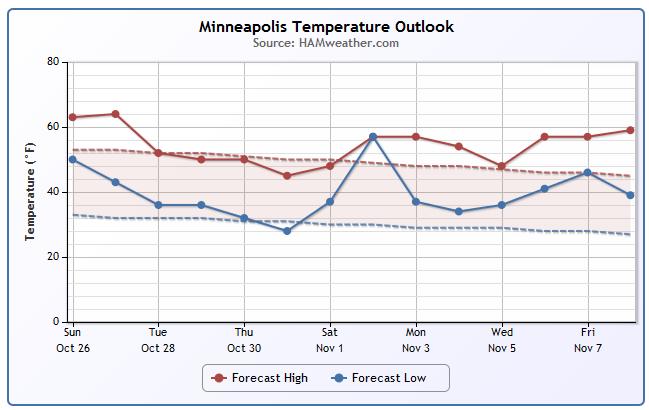
Minneapolis Temperature Trend
Easing into Fall... Fall weather this year has been has been incredible, no question. Despite a decent cool down this week, we'll actually get back to average weather for this time of the year. Extended weather models suggest another warm up though during the early part of November. Not sure how long we can keep this going... it's just a matter of time before the other shoe drops. Stay tuned!
==============
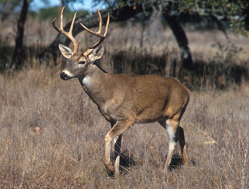
Nature Notes by Freshwater Society
5th Week of October
"White-tailed deer are in their mating season and the fresh scrapes and rubs of rutting bucks can be spotted in the woods. Franklin's gulls and ring-billed gulls follower farmers doing fall plowing to pick up worms and other small animals in the soil. When the leaves have passed their peak of brilliance and fallen from the trees, they turn into humus that eventually will feed the parent tree as well as other plants. American bittersweet, a native vine found throughout much of the state, has clusters of bright red-orange seeds. The seeds hang on through winter or until birds such as wild turkeys or eastern bluebirds eat them."
See more from Freshwater Society HERE:
Monday Weather Outlook
A cold front sweeping through the area Sunday Night/Monday will keep scattered light rain showers in place through Monday. Not much rain is expected, but cooler temperatures through much of the week will be the result of the passing cold front.
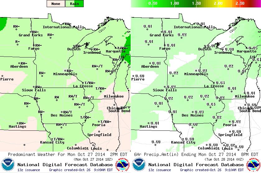
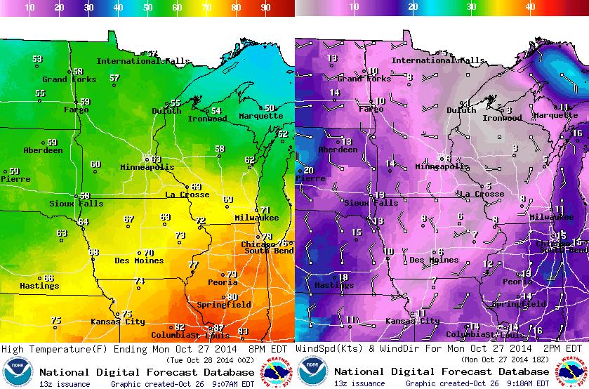
Temperatures will begin to drop early this week. Our beautiful weekend weather gets pushed southeast into the Ohio Valley as colder air begins to drop out of Canada. Highs across northern Minnesota will only make it into the 50s, while highs in the southern part of the state will struggle to get to 60.
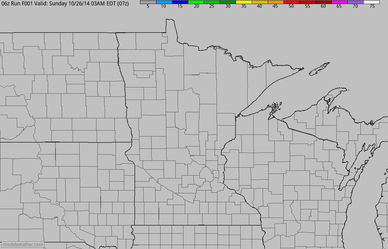
Simulated Radar
Here's the simulated radar through Tuesday, which shows rounds of showers and storms rolling through the Upper Midwest. Some of the heaviest precipitation looks to fall across northern Minnesota and Wisconsin.
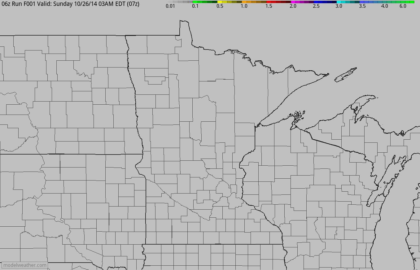
Accumulated rainfall through Tuesday looks heaviest across parts of northern Minnesota and Wisconsin. Don't be surprised if some of this rainfall is accompanied by a few rumbles of thunder.
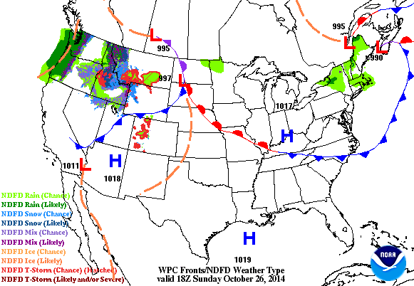
National Weather Outlook
The loop below shows active weather continuing in the western part of the country. These storms continue eastward into our next of the woods and the first of these impulses of energy will be moving through the Upper Midwest early this week. Heavy rainfall will be possible where thunderstorms develop and a little wintry mix will be possible on the backside of the storm as colder air wraps in behind it. Note the secondary storm system moving into the western U.S. - that storm will actually bring much needed precipitation to more of California by next weekend!
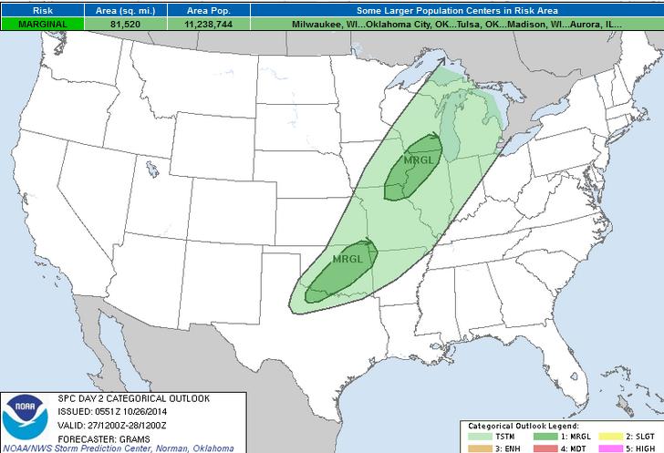
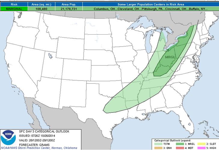
Isolated Severe Threat?
According to NOAA's SPC, there is a MARGINAL severe threat Monday and Tuesday east of the Mississippi Valley as the front sweeps east. If you think the severe threat map looks a little different, it does! The Storm Prediction Center implemented a new severe threat map earlier this month.
"The October 22 changes expand the risk categories from four to five. They also clarify the risk previously labeled as “See Text,” which will be replaced by a line outlining the category and the term “Marginal” to denote areas with a 5 percent probability of severe weather."
To find out more about the change to the severe risk maps, see more from the Capital Weather Gang HERE:
Monday Severe Threat
...SRN GREAT PLAINS TO UPPER MS VALLEY... MOISTURE RETURN AHEAD OF THE FRONT WILL BE MODEST AND CONSIST OF A MODIFIED CP AIR MASS WITH MT AIR CURRENTLY RELEGATED TO THE CARIBBEAN. ORIENTATION OF THE TROUGH AND FRONT WILL FAVOR PREDOMINATELY SWLY FLOW WITH AN EML PLUME OVER THE WARM SECTOR...LIKELY MAINTAINING SUBSTANTIAL INHIBITION FOR SURFACE-BASED STORMS. OVER THE SRN GREAT PLAINS...WEAK MID-LEVEL HEIGHT FALLS IN CONJUNCTION WITH LOW-LEVEL LIFT WITHIN THE FRONTAL ZONE SHOULD FOSTER AT LEAST ISOLATED ELEVATED CONVECTION AFTER DARK. ALTHOUGH BUOYANCY SHOULD REMAIN WEAK WITH MUCAPE AOB 1000 J/KG...STEEP MID-LEVEL LAPSE RATES AND ROBUST SPEED SHEAR SHOULD FAVOR A RISK FOR MARGINALLY SEVERE HAIL. ACROSS THE UPPER MS VALLEY...LARGE-SCALE ASCENT WILL BE PRONOUNCED AHEAD OF THE AMPLIFYING TROUGH. THIS MAY BE SUFFICIENT TO OVERCOME INHIBITION AND YIELD NEAR SURFACE-BASED CONVECTION ON THE NRN PERIPHERY OF THE MODEST WARM SECTOR MOISTURE PLUME BY MON EVENING. INITIALLY STEEP MID-LEVEL LAPSE RATES AND STRONG DEEP-LAYER SWLYS MAY SUPPORT MARGINALLY SEVERE HAIL AND PERHAPS LOCALLY DAMAGING WINDS.
Tuesday Severe Threat
...LOWER GREAT LAKES TO KY... DESPITE POLEWARD LOW-LEVEL MOISTURE ADVECTION AHEAD OF THE FRONT...MEAN MIXING RATIOS SHOULD REMAIN MODEST AND IN CONJUNCTION WITH PERVASIVE MOIST-ADIABATIC MID-LEVEL LAPSE RATES...BUOYANCY WILL REMAIN MEAGER. NEVERTHELESS...WRF-BASED GUIDANCE SUGGESTS TEMPERATURES SHOULD WARM INTO THE 70S DOWNSTREAM OF MORNING FRONTAL CONVECTION. THIS STEEPENING OF LOW-LEVEL LAPSE RATES OCCURRING AMIDST STRONG TO INTENSE MID/UPPER-LEVEL FLOW WOULD LIKELY YIELD STORMS INTENSIFYING DURING THE AFTERNOON WITH A RISK FOR AT LEAST ISOLATED DAMAGING WINDS. STILL...WITH THE MID-LEVEL TROUGH SHIFTING AWAY FROM THE CONUS...ORIENTATION OF DEEP-LAYER FLOW WILL LARGELY PARALLEL THE FRONT AND LOW-LEVEL WINDS SHOULD DIMINISH /ESPECIALLY WITH SWRN EXTENT/. THESE FACTORS ALONG WITH THE ANTICIPATED SCANT BUOYANCY WILL PRECLUDE HIGHER SEVERE PROBABILITIES THIS OUTLOOK.
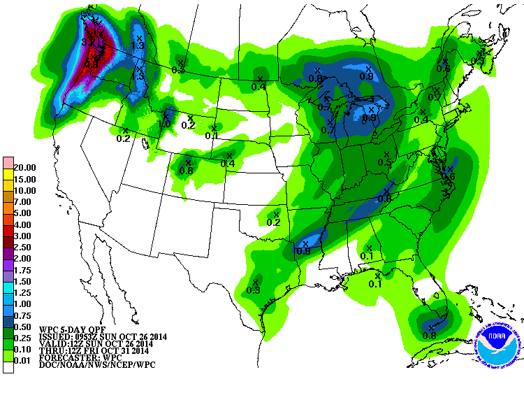
Precipitation Outlook
According to NOAA's HPC, the 5 day precipitation forecast keep most of the heavy moisture this week across the Pacific Northwest. Interestingly, some of this moisture will be from Ana, the same storm that impacted Hawaii last weekend!
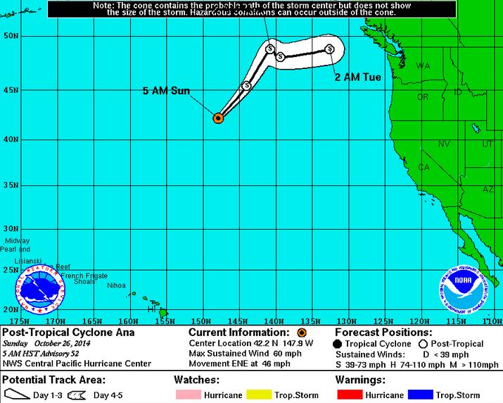
Tracking Ana
As of early Sunday, Ana had weakened to a Post-Tropical Cyclone with sustained winds of 58mph as it quickly moved northeast towards the Pacific Northwest. Interestingly, this is the same storm that impacted Hawaii last weekend!
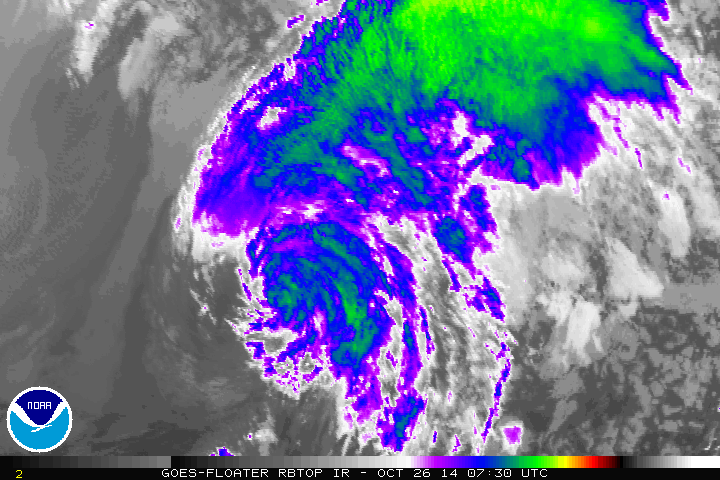
Tracking Ana
As of early Sunday, the Central Pacific Hurricane Center had the remnants of Ana moving closer and closer to the Pacific Northwest through the early week. It's not often than we see tropical systems this far north, so it certainly is noteworthy!
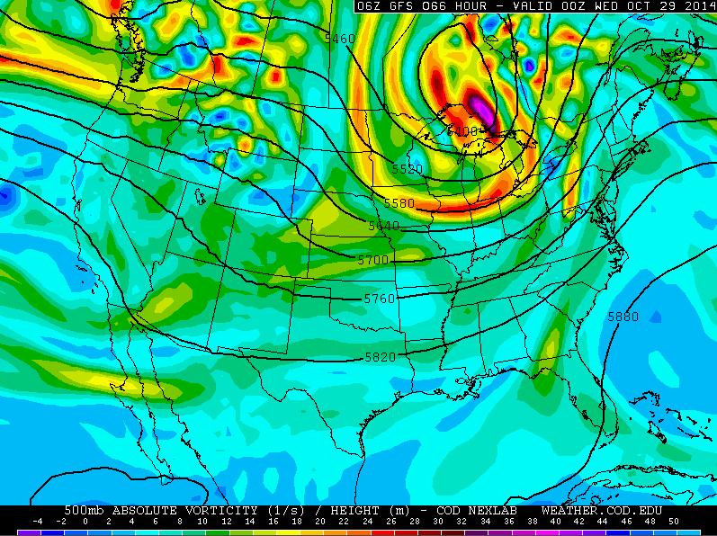
Looking Ahead... Tuesday
Tuesday looks like a fairly chilly day across the region. However, although temperatures will be quite a bit cooler than what we've been dealing with, we'll actually be closer to where we should be at this time of the year. The image below shows the trough of low pressure swinging through the Upper Midwest/Great Lakes by Tuesday. This will keep things a bit unsettled and also drop temperatures.
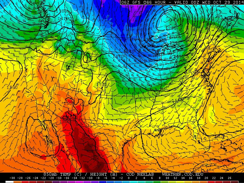
Tuesday 850mb Temperatures
Note how the 850mb temperature profile mimics that of the upper level 500mb vorticity (spin) map above. The colder air will ride in on the backside of the storm system through the end of the week/weekend ahead.
Tuesday Temperatures
Temperatures will be quite a bit colder by midweek, but interestingly, we'll actually be closer to average. Temperatures across the Plains in Rockies will be slightly below average on Tuesday.
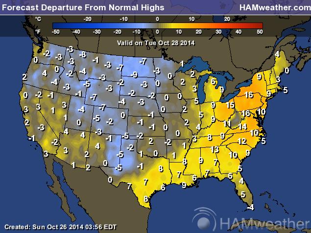
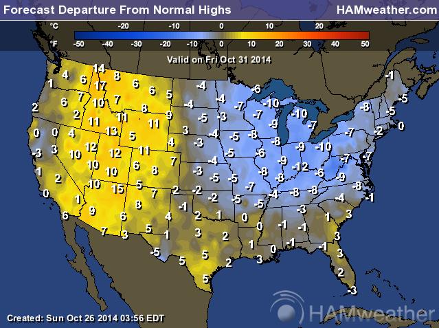
Halloween Outlook
Temperatures on Halloween look to be a bit chilly as well. In fact, temperatures will be nearly 5 to 10 degrees below average... Ghosts and goblins might need an extra layer under their costume this year.
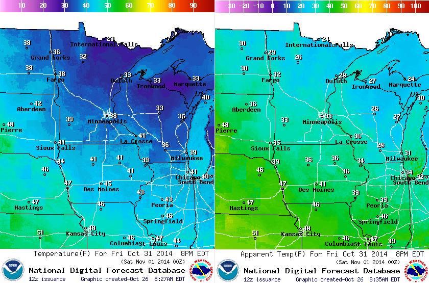
Halloween Outlook Cont.
Here's a glance at temperatures by 8pm Friday (Halloween Night). Actual air temperatures will be dropping into the 30s, while feels like temperatures will be more like the 20s and lower 30s. Again, it looks like many will need an extra layer heading out for tricks and treats.
Thanks for checking in and have a great week ahead! Don't forget to follow me on Twitter @TNelsonWX

No comments:
Post a Comment