26 F. high in the Twin Cities Wednesday.
35 F. average high on November 26.
31 F. high on November 26, 2013.
2.2" snow fell yesterday at MSP International Airport.
November 26 in Minnesota Weather History. Source: Twin Cities National Weather Service:
2005: In the early morning a home in Mower County was hit by lightning and burned to the ground, but no one was injured.
1994:
A low pressure system had developed into the first Winter storm for
Minnesota. By the early morning hours of the 28th, a swath of snow in
excess of 6 inches had blanketed much of southwest through central into
northeast Minnesota. Snowfalls of 6 inches or more occurred south of a
line from Gunflint Lake in Cook county to near Ortonville in Big Stone
county and along and north of a line from near Blue Earth in Faribault
county to Red Wing in Goodhue county. The snow closed the
Minneapolis-St. Paul International Airport for a short time on the 27th,
and contributed to hundreds of accidents and at least three fatalities.
In addition, the build-up of ice and snow in combination with strong
winds resulted in numerous downed power lines in southeast Minnesota.
1985: Cold hits northern Minnesota. 30 below zero at Crookston.
1971: Heavy snows in the Southwest. Redwood Falls gets a foot.
Giving Thanks
"Be
thankful for what you have; you'll end up having more. If you
concentrate on what you don't have, you will never, ever have enough."
Oprah got that right.
I'm thankful for my faith, friends and
family - humbled to be married to the same amazing woman for 30 years -
grateful that both my boys want to live in Minnesota - thrilled to be
living in a state where readers know (a lot) about the weather. I'm also
thankful I don't own a home near an earthquake fault or sea level;
happy to be living in a state blessed with abundant water.
We all
feel a drizzle of disappointment with our lives from time to time, but
writing down things to be thankful for highlights just how lucky we all
are to be living right here, right now.
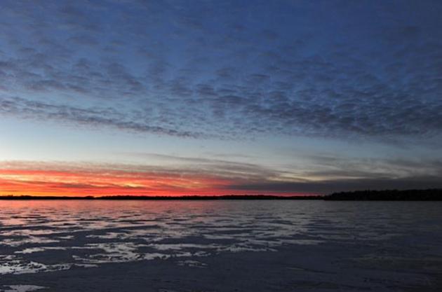
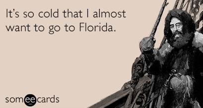
Yes, it's cold, but the
sun's out and winds are easing up. No travel problems today. An inch of
powder falls tomorrow as you slip/slide your way to that big Black
Friday sale. Models confirm fleeting 30s Saturday - a cold slap early
next week, then milder air late next week as milder, Pacific air
penetrates inland the second week of December. No Indian Summer in
sight, but right now I'm thankful for the prospect of 30s.
Happy Thanksgiving to you and yours!
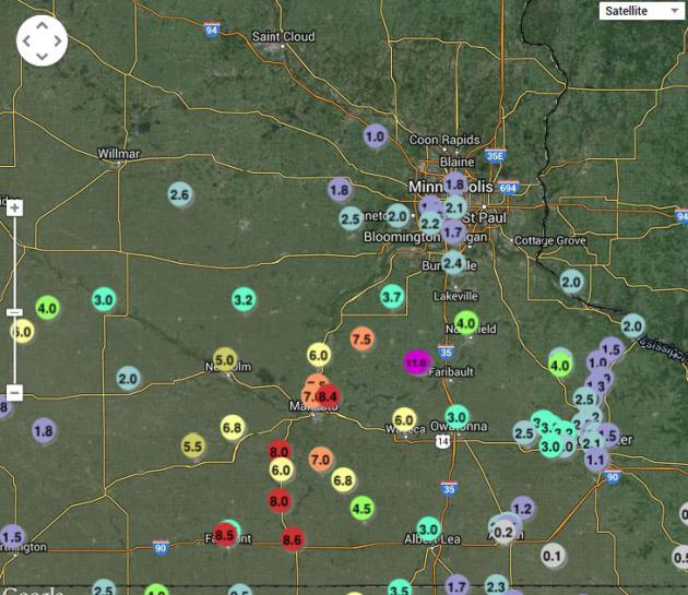 Wednesday Snowfall Amounts.
About 1-3" snow fell across most of the metro, but 4 at Northfield and
closer to 8" near Mankato and Fairmont. Clipper snows are especially
fickle, as the map above seems to demonstrate.
Click here for the NWS snowfall update.
Thanksgiving Trivia. Here's an excerpt of some information I wasn't aware of about the origins of Thanksgiving, courtesy of Dr. Mark Seeley at
WeatherTalk: "...
When
harvests were made bountiful by a blessed rain or abundant sunshine or
when fish and game were caught in great numbers by hunters and
fishermen, a community might declare a Thanksgiving Day to celebrate
these gifts. Alternatively, if the winter was harsh, game was scarce,
there was spring flooding, or drought related forest fires, then a
community might declare a Fasting Day in an attempt to reconcile with
God..."
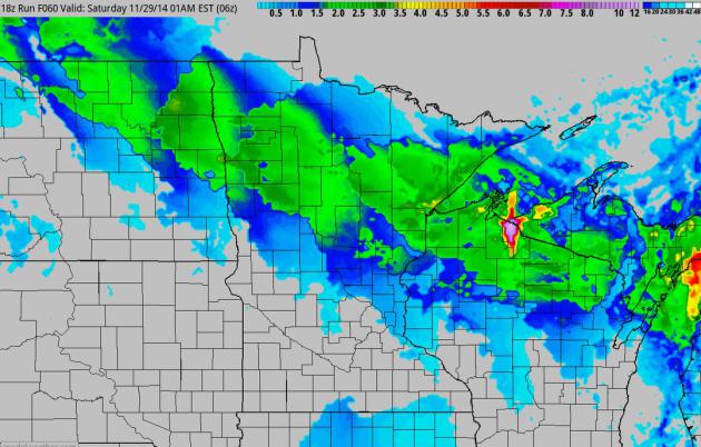 Additional Snow by Midnight Friday Night.
The approach of milder air coupled with a jet streak sparks a smear of
light snow over northern Minnesota and Wisconsin on Friday. A coating to
1" of accumulation is possible in the metro, maybe closer to 2" from
Brainerd to Duluth. Map: NOAA and HAMweather.
 Numb - Thaw - Repeat.
The pattern still isn't ripe for any major storms (which usually
approach from Denver, or more typically Oklahoma City, laden with
moisture from the Gulf of Mexico). The best chance of a welcome thaw:
Saturday, again the end of next week. Graphic: Weatherspark.
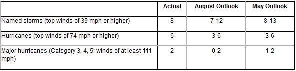
Atlantic Hurricane Season Stays Quiet As Predicted. Here's a wrap-up of yet another fairly tame, benign Atlantic hurricane season, courtesy of
NOAA. The Pacific was another matter altogether: "...
A
combination of atmospheric conditions acted to suppress the Atlantic
hurricane season, including very strong vertical wind shear, combined
with increased atmospheric stability, stronger sinking motion and drier
air across the tropical Atlantic,” said Gerry Bell, Ph.D., lead
hurricane forecaster at NOAA’s Climate Prediction Center.
“Also, the West African monsoon was near- to below average, making it
more difficult for African easterly waves to develop.” Meanwhile, the
eastern North Pacific hurricane season met or exceeded expectations with
20 named storms – the busiest since 1992..."
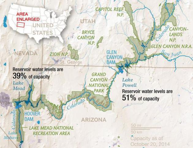
Record Drought Reveals Stunning Changes Along Colorado River. National Geographic has a story worth your time; here's an excerpt: "...
According
to modern tree-ring data (unavailable during the dam-building epoch),
the previous millennium experienced droughts much more severe than those
in the first 14 years of the 21st century. Many climate scientists
think the Southwest is again due for a megadrought. The Bureau of
Reclamation's analysis of over a hundred climate projections suggests
the Colorado River Basin will be much drier by the end of this century
than it was in the past one, with the median projection showing 45
percent less runoff into the river..."
Map credit above: Virginia W. Mason, NG Staff Source: Bureau of Reclamation, National Park Service.
Social Media Rescues Snow-Bound Stations.
Local television stations in Buffalo were at a distinct disadvantage
trying to cover last week's 5-8 foot lake effect snowfall; reporters and
live trucks unable to get into the most impacted neighborhoods on the
south side of the city.
TVNewsCheck
has an article focused on social media, how trapped, marooned residents
provided much of the content stations relied on to tell the story;
here's an excerpt: "...
As the snow piled up, the stations went
wall-to-wall with their coverage, but were short-staffed (like many
viewers, reporters and producers were trapped in their homes) and unable
to put ENG vehicles on snow-clogged streets. “The old style of
newsgathering was not going to happen. We knew that from the start,”
Woodard says, who gave up getting into work after six hours that day..."
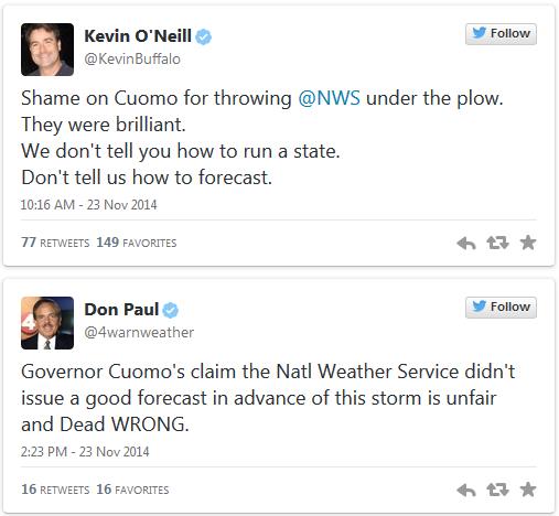
Politicians, Please Stop Blaming Meteorologists For Inept Storm Responses.
Because crap flows downhill and it's easier to kick the local National
Weather Service or TV meteorologists for not forecasting an apocalyptic
7-8 feet of snow. The forecast called for 1-3 feet, as meteorologist
Eric Holthaus points out in
Slate: "...
Cuomo
said that “no one had an idea” that Buffalo was in for such a wallop
and that the National Weather Service “was off” on its forecasts. Well,
Mr. Governor, the National Weather Service wasn’t off. In fact, if you
look back at official forecasts in the days and hours leading up to the
first flakes, it was pretty much spot-on—nailing the 5-inch-an-hour superstorm of snow the city received in the initial stages of a double-whammy snowstorm that produced up to 88 inches. Instead, highways were left open and commuters traveled to work—only to be frozen in place for most of the rest of the day..."
Why Do We Force Weather Forecasters To Lie To Us?
Lie is such a strong word; we phrase the forecast, especially for
summer weekends, knowing how weather forecasts are consumed at home, and
it's better to err on the side of caution (and slight pessimism).
Here's an excerpt from
io9.com: "...
Nate
Silver examined this in his books, The Signal and the Noise, and found
that weather channels to this because, "People don't mind when a
forecaster predicts rain and it turns out to be a nice day. But if it
rains when it isn't supposed to, they curse the weatherman for ruining
their picnic." Yes, we're wrong to act out at forecasters, but is a
little bias so bad? There's a reason people will assume that the
worst-case scenario will always happen. Not only are they prepared if
things go south, they get a little bump of happiness if things work out
better than expected..."
Why There Should Be A Pen On Your Thanksgiving Table. It's easy to miss the forest through the trees - part of the human condition, I guess. Here's an excerpt from
Huffington Post: "...
Just this small stunt -- the physical action of jotting down a couple of things you're happy to have in your life -- has been shown to
reinforce happy thoughts. Our brains have a tendency to focus on the
negative, so this action helps to stop our thoughts from going down a
dark path and bring them back on a happy trail...."
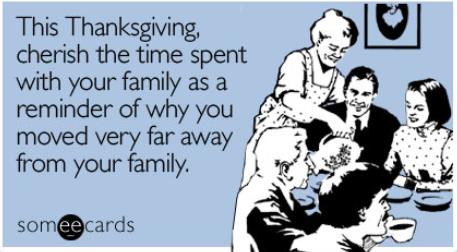
Why Your Family Drives You Crazy. How much time do you have? Vox outlines some of the reasons why letting your guard down around family is a bad idea: "...
The
main reason why family members clash in this way is the same reason why
they love each other so much: comfort. Family members know each other
so well — too well — and that means they feel comfortable around each
other. There are obviously great benefits to being in relationships
where people feel accepted and secure. But comfort is a double-edged
sword. It means that individuals feel safe showing every side of
themselves to others — the good and, unfortunately, the bad and the ugly..."
The Worst Days To Fly in the U.S., Ranked. It's not the day before Thanksgiving, after all, according to
Quartz. Here's a clip: "...
The
three busiest days to fly in the US are all in the summer. In 2013,
they were July 18, 25, and 11, according to airport operations data from
the FAA. Those were the three consecutive Thursdays following US
Independence Day on July 4th (which was the 21st least-busiest day to
fly)...."
THANKSGIVING: Sunny, contentedly numb. Winds: NW 5. High: 14
THURSDAY NIGHT. Clouds increase, flurries late. Low: 10
BLACK FRIDAY: 1-2" of light snow possible. Slippery roads. High: 27
SATURDAY: Welcome thaw. Patchy clouds. Wake-up: 24. High: 37
SUNDAY: Mostly cloudy, much colder wind. Wake-up: 21. High: 24 (falling)
MONDAY: Bright, ineffective sun. Wind chill: -5. Wake-up: 4. High: 15
TUESDAY: Clouding up, windy. Not as cold. Wake-up: 11
WEDNESDAY: Partly sunny, still brisk. Wake-up: 9. High: 25
Climate Stories...
What Global Warming? Pass Me A Blanket. The current weather seems to influence our overall perception of climate change, as reported by Bloomberg and
Japan Times; here's an excerpt: "...
When
people think the day’s weather is exceptionally cold, research shows,
they’re less likely to be concerned about global warming. And when the
day seems unusually hot, concern jumps. Notably, this effect can be
found among Republicans and Democrats, men and women, young and old.
Strange but true: As the question of climate change receives sustained
attention in Washington in the coming months, public opinion is likely
to be affected by short-term swings in the weather..."
Americans Would Rather Adapt To Extreme Weather Than Curb Climate Change. Yes,
the pragmatist in me tells me that it may come to this - easier adapt
than mitigate. But adapting to rising sea level, more frequent and
severe drought, diminishing water supplies and frequent extreme floods
will require a level of innovation that simply doesn't exist today.
Here's a clip from
The Christian Science Monitor: "
Americans
generally may be more ready to adapt to extreme weather and climate
events, which are projected to become more frequent with global warming,
than to curb greenhouse-gas emissions driving the long-term warming
trend. That is the implication of a new study exploring the relative
influence that extreme events, a person's spot on the political and
ideological spectrum, as well as gender, age, education, and perceptions
about the existence and causes of global warming have on their views on
the subject..." (File photo: AP).
The Impacts of Temperature Anomalies and Political Orientation on Perceived Winter Warming. A link to the paper from
Nature Climate Change is here.
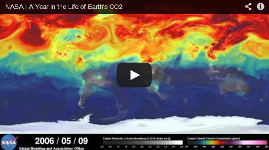
Both Beautiful and Disturbing: New NASA Visualization Shows Carbon Dioxide Emissions Swirling Around The World. Discover Magazine has the story and animation; here's a snippet: "...
Courtesy of the NASA Goddard Space Flight Center,
the visualization — produced by an ultra-high-resolution computer model
and spanning May 2005 to June 2007 — shows weather patterns sweeping
plumes of carbon dioxide into the atmosphere. In the Northern
Hemisphere, major sources of human-caused emissions are concentrated in
North America and Asia, especially China, as well as Europe..."


No comments:
Post a Comment