-4 F. low in the Twin Cities Thursday.
10 F. high yesterday at MSP.
34 F. average high on November 27.
25 F. high on November 27, 2013.
November 27, 1998:
The morning low in Rochester, MN of 54 degrees was actually higher than
the previous record high for the date. The temperature would reach 62
degrees during the day, smashing the old record of 53
November 27, 1983:
Widespread snowfall occurred across much of central Minnesota with
snowfall totals at or above 1 foot in many areas. A record 15 inches
fell in Gaylord and 14 inches fell in Farmington.
November 27, 1960:
Major storm produces near hurricane force winds on Lake Superior, with
20 to 40 foot waves on the lake. Erosion and damage occurred on the
North Shore. Source: NOAA.
 Backwards Winter
If
you look at the data, "meteorological winter", marking the coldest 90
days of the year, historically, begins on December 1, not the 21st.
Temperatures in Minnesota tend to bottom out in mid or late January, if
anyone has the temerity to ask. Doubtful.
Which is why today's
computer models are such a head-scratcher. For months now we've been
tracking predictions of El Nino, a mild stain in the Pacific, which
warms the air thousands of miles downwind. El Nino usually keeps
Minnesota's winters a bit milder, re-routing the jet stream, trapping
some of the coldest air over Canada. It's been delayed, but the El Nino
signature is finally showing up - and it may soon spark a milder shift
in the steering winds blowing into Minnesota.
The
coldest Thanksgiving since 1985
gives way to icing today as milder air returns - the mercury hits 40F
Saturday before tumbling again early next week. An extended Pacific thaw
sets in late next week and spills over into the second week of
December. Not exactly Indian Summer but a string of 30s and 40s are
possible.
An early January Thaw? After a Nanook November maybe we'll catch a minor break next month.
This will NOT be a rerun of last winter.
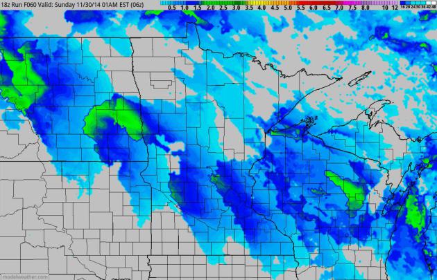
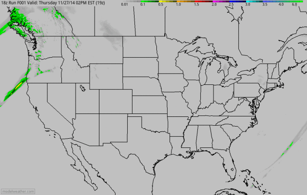
Clipped Again.
A weak storm aloft rippling along an advancing warm front will set off a
few hours of snow this morning; a quick inch or two of powder can't be
ruled out - snow can pile up pretty fast when it's this cold. 4 km NAM
snowfall accumulation: NOAA and HAMweather.
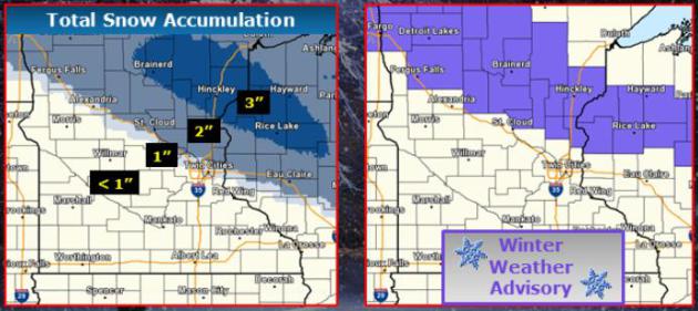 Minnesota Ice
.
The Twin Cities Office of the National Weather Service tracks the
greatest potential for a plowable accumulation early this morning:
north/east of MSP. A little freezing drizzle/rain may add to the icing
this morning.
A Shifting Pattern?
I'm seeing symptoms of a strengthening El Nino warm phase of the
Pacific, warmer equatorial water pulling the storm track farther south,
so L.A. and San Diego may see rain in the coming weeks, along with the
Bay Area. Soaking rains pushing into the Pacific Northwest and northern
California over the next 60 hours, and I suspect some of this milder,
Pacific-sourced air will push into Minnesota by the end of next week,
spilling over into at least mid-December.
Growing Opportunities To Sample Freezing.
Here in the Land of Low Weather Expectations 32F can be a Godsend. Such
will be the case Saturday, again the end of next week into much of the
second week of December. I'm going to pretend it's a late (timid) case
of Indian Summer. The pattern isn't ripe for major storms anytime soon.
Why There Should Be A Pen On Your Thanksgiving Table. It's easy to miss the forest through the trees - part of the human condition, I guess. Here's an excerpt from
Huffington Post: "...
Just this small stunt -- the physical action of jotting down a couple of things you're happy to have in your life -- has been shown to
reinforce happy thoughts. Our brains have a tendency to focus on the
negative, so this action helps to stop our thoughts from going down a
dark path and bring them back on a happy trail...."
Why Your Family Drives You Crazy. How much time do you have? Vox outlines some of the reasons why letting your guard down around family is a bad idea: "...
The
main reason why family members clash in this way is the same reason why
they love each other so much: comfort. Family members know each other
so well — too well — and that means they feel comfortable around each
other. There are obviously great benefits to being in relationships
where people feel accepted and secure. But comfort is a double-edged
sword. It means that individuals feel safe showing every side of
themselves to others — the good and, unfortunately, the bad and the ugly..."
The Worst Days To Fly in the U.S., Ranked. It's not the day before Thanksgiving, after all, according to
Quartz. Here's a clip: "...
The
three busiest days to fly in the US are all in the summer. In 2013,
they were July 18, 25, and 11, according to airport operations data from
the FAA. Those were the three consecutive Thursdays following US
Independence Day on July 4th (which was the 21st least-busiest day to
fly)...."
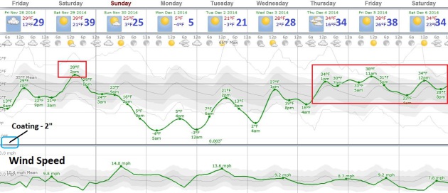
 TODAY
TODAY: Coating to 2" snow and ice early - slippery roads AM hours. Winds: South 10. High: 29
FRIDAY NIGHT: Lingering clouds. Low: 24
SATURDAY: Patchy clouds, welcome thaw! High: near 40
SUNDAY: Mostly cloudy, much colder wind. Wake-up: 25. High: 27 (falling during the day)
MONDAY: Sunny, less wind. Feels like -10F. Wake-up: 1. High: 12
TUESDAY: Clouds and coating of flurries. Wake-up: 6. High: 25
WEDNESDAY: Partly sunny, not as harsh. Wake-up: 16. High: 28
THURSDAY: Slow warming trend. Getting better. Wake-up: 19. High: 33
Climate Stories...
Warming Pacific Drives Global Temperatures. Here's an excerpt from
reportingclimatescience.com: "..
.The
northern hemisphere summer of 2014 has seen the highest global mean sea
surface temperatures recorded since systematic measuring started. Sea
surface temperatures have exceeded those of the record-breaking 1998 El
Nino year. Timmermann used the phrase “quite remarkable” to describe
what has been happening and Trenberth called the events “extraordinary”.
Both men told reportingclimatescience.com that they believe this
warming may mean the end of the so called pause, or hiatus, in global
warming - which, according to some measures, has been going on since the
mid-1990s..."
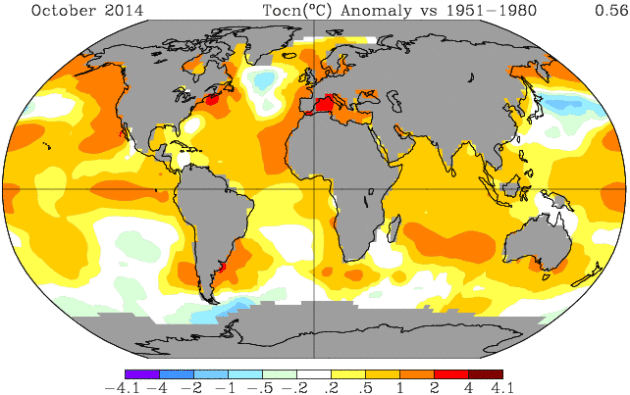
Map credit: "
Global sea surface
temperature anomaly in October 2014 versus the long term average
1951-1981. Note: Gray areas signify missing data." Courtesy NASA.
What Global Warming? Pass Me A Blanket. The current weather seems to influence our overall perception of climate change, as reported by Bloomberg and
Japan Times; here's an excerpt: "...
When
people think the day’s weather is exceptionally cold, research shows,
they’re less likely to be concerned about global warming. And when the
day seems unusually hot, concern jumps. Notably, this effect can be
found among Republicans and Democrats, men and women, young and old.
Strange but true: As the question of climate change receives sustained
attention in Washington in the coming months, public opinion is likely
to be affected by short-term swings in the weather..."
Americans Would Rather Adapt To Extreme Weather Than Curb Climate Change. Yes,
the pragmatist in me tells me that it may come to this - easier adapt
than mitigate. But adapting to rising sea level, more frequent and
severe drought, diminishing water supplies and frequent extreme floods
will require a level of innovation that simply doesn't exist today.
Here's a clip from
The Christian Science Monitor: "
Americans
generally may be more ready to adapt to extreme weather and climate
events, which are projected to become more frequent with global warming,
than to curb greenhouse-gas emissions driving the long-term warming
trend. That is the implication of a new study exploring the relative
influence that extreme events, a person's spot on the political and
ideological spectrum, as well as gender, age, education, and perceptions
about the existence and causes of global warming have on their views on
the subject..." (File photo: AP).


No comments:
Post a Comment