No Comment
By Paul Douglas
"Is there such a thing as a TROPICAL VORTEX? Please say YES, even if there isn't" e-mailed Slade Schuster last week. Thanks for the chuckle, Slade. It may be challenging keeping a sense of humor this week as polar air surges south - again.
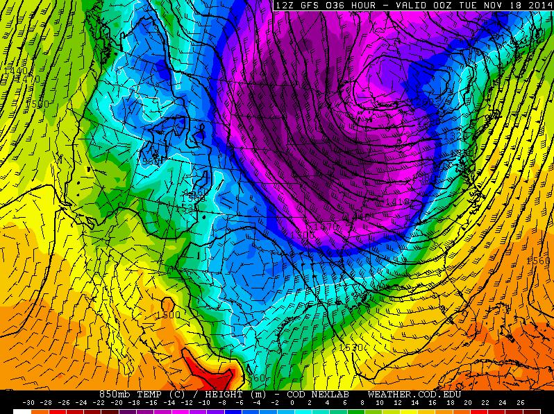
The jet stream is wobbling, buckling and misbehaving, much like last winter. The air isn't quite as cold (yet) but yes, the pattern looks similar. For me the bigger question is will it last? What made last winter's polar displacement so unusual was its persistence. The bitter blob all but stalled for the better part of 3 months. Assuming El Nino forms this winter (better than 50-50 odds) then the upcoming winter shouldn't be a carbon-copy of last winter. Annoyingly cold. But probably not pioneer cold.
Time to dig out the warmest clothes of winter; highs hold in the teens today & Tuesday - it may feel like -15F at the bus stop Tuesday morning. Sunshine increases by midweek with a pleasing puff of Pacific air nudging the mercury into the 30s by the weekend. No big storms are expected to foul up travel plans between now and Thanksgiving.
In the meantime I'm tracking a rare "tropical vortex". The only problem: it'll miss us by 2000 miles.
========
SUNDAY NIGHT: Areas of light snow & blowing snow overnight. Low: 7. Winds: WSW 10-15mph
MONDAY: Numb and Number! Cold with areas of snow and blowing snow. AM wind chill: -10F. High: 17. Winds: WNW 10-20mph gusts to 30mph!
MONDAY NIGHT: Mostly cloudy, breezy and cold. Wind chill: -15F. Low: 3
TUESDAY: Peeks of sun, cold wind. High: 15.
WEDNESDAY: More clouds than sun. Hibernating... Wake-up: 5. High: 21
THURSDAY: More sun, less wind. Still too cold! Wake-up: 7. High: 19
FRIDAY: Clouds increase, not as chilly. Wake-up: 8. Low: 26.
SATURDAY: First thaw in 13 days. Icy late? Wake-up: 22. High: 34.
SUNDAY: Light mix possible. Wet roads. Wake-up: 30. High: 36.
=============
This Day in Weather History
November 17th
1996: Six inches of snow fell in Douglas, Pope, and Stevens Counties.
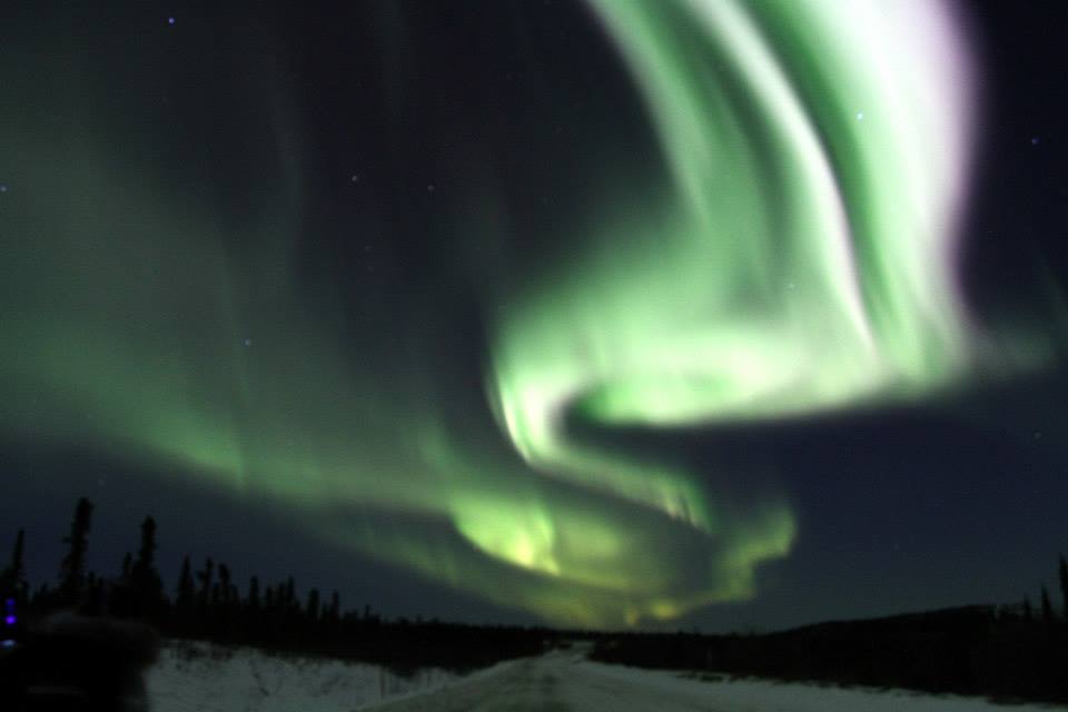
1835: Strange night at Ft. Snelling. Northern lights seen over prairie fires.
=============
Average High/Low for Minneapolis
November 17th
Average High: 40F (Record: 71F Set in 1953)
Average Low: 26 (Record: -5F Set in 1880)
==============
Sunrise/Sunset Times for Minneapolis
November 17th
Sunrise: 7:13am Sunset: 4:42pm
==============
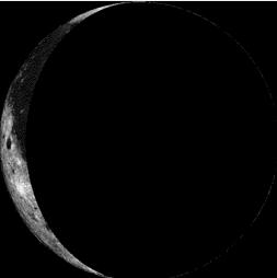
Moon Phase for November 17th at Midnight
3.7 Days After Last Quarter
===============
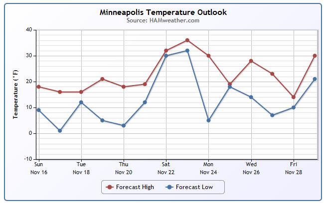
Minneapolis Temperature Trend
I keep shaking my head wondering what month it is... It looks and feels more like January than November! The good news is that after another VERY cold week (for November), we get a much needed thaw by the weekend. Not sure how long lasting it'll be as some of the long range models suggests another winter chill by the end of the month.
Monday Weather Outlook
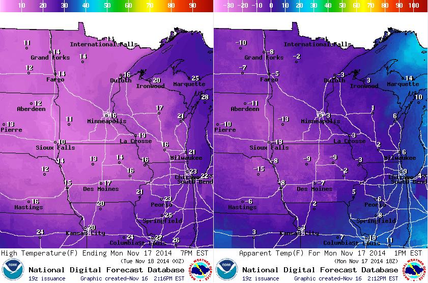
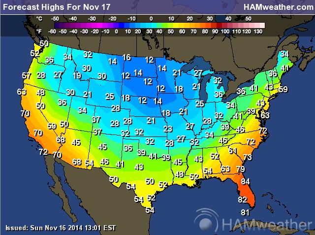
The images below suggest high temperatures Monday (Left) and feels like temperatures at noon (Right). Keep in mind that the average high for November in the Twin Cities is right around 40F, it is going to be nearly 25F below average with feels like temperatures in the sub-zero range - YIKES!
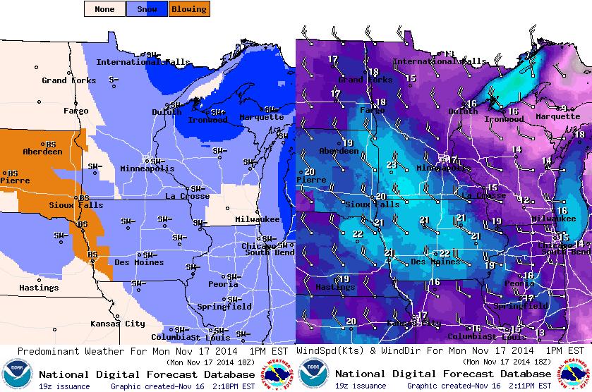
Monday Weather Outlook
A little snow and breezy winds on Monday will create some blowing snow issues across parts of Southwest Minnesota through much of Monday. Blowing and drifting snow could cause some visibility and slippery issues on the roadways.
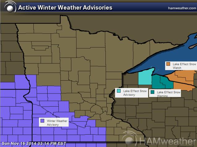
Winter Weather Advisory
Thanks to cold weather and breezy northwest winds, lake effect snow will be prominent across the south shore of Lake Superior. Breezy winds will also be an issue for open country across southwestern Minnesota as blowing snow could cause some visibility and slippery road issues through Monday.
...WINTER WEATHER ADVISORY NOW IN EFFECT UNTIL 6 PM CST MONDAY...
THE WINTER WEATHER ADVISORY IS NOW IN EFFECT UNTIL 6 PM CST MONDAY.
* MAIN IMPACT...NORTHWEST WINDS OF 20 TO 25 MPH...WITH GUSTS UP TO 40 MPH...WILL PRODUCE AREAS OF BLOWING AND DRIFTING SNOW AND OCCASIONAL VISIBILITIES LESS THAN A 1/2 MILE IN OPEN AREAS.
* OTHER IMPACTS...TRAVEL WILL BE HAZARDOUS WITH REDUCED VISIBILITIES AND DRIFTING OF SNOW OVER ROADWAYS.
* TIMING...LATE THIS AFTERNOON THROUGH MONDAY.
Weather Outlook
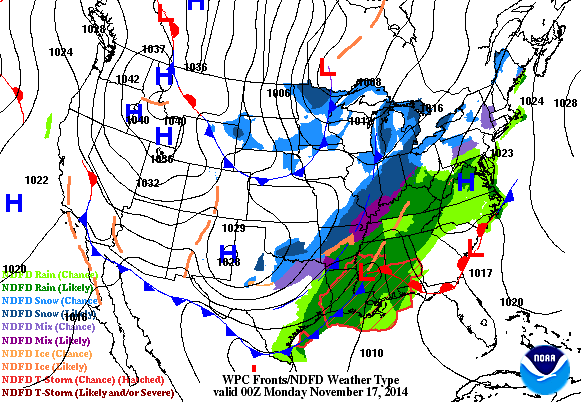
Our cold weather locally is being enhanced by a fairly large storm wrapping up over the eastern part of the country early this week. Heavier rain along the coast will transition into a rain/snow mix farther inland. Snow accumulations will be found along and west of the Appalachians.
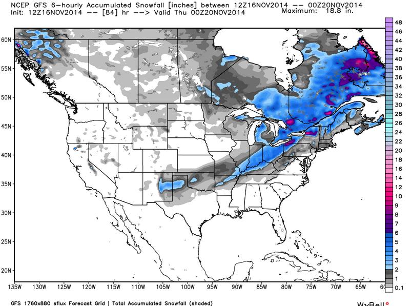
Snow Potential Through Midweek
As the storm mentioned above slides northeast, snow potential will be found on the northwest flank. Areas of shovelable snow may be possible from portions of the Southern Plains to the Northern New England States through midweek.
Continued Cold This Week
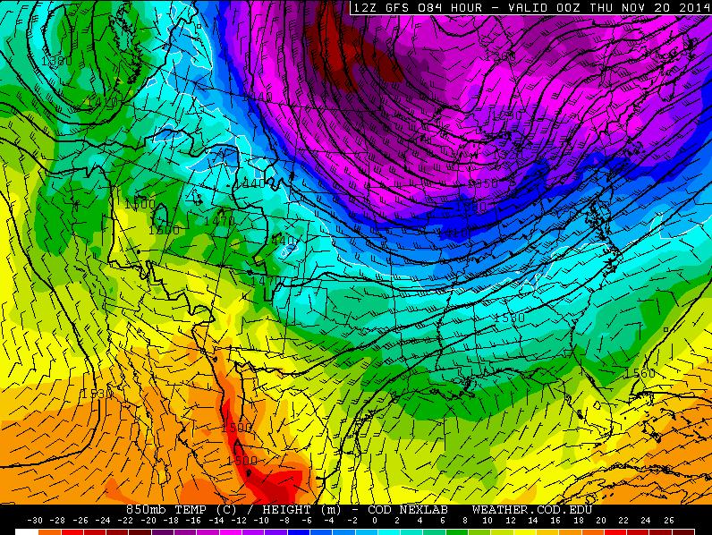
The images below suggests the temperature outlook through the week ahead, note how the cold air has entrenched itself across much of the eastern two-thirds of nation. The only relief in sight is perhaps this upcoming weekend!
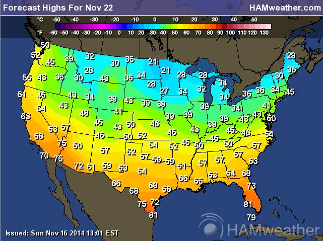
Monday Temperature Outlook
Highs Monday
High temperatures on Monday look more reminiscent of January rather than mid November!
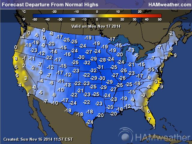
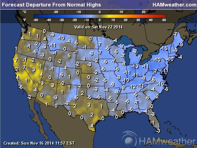
Monday Highs From Average
High on Monday will be significantly below average for much of the nation. Interestingly, this cold weather has been pretty persistent for nearly one week!
Temperature Outlook Wednesday
Temperature Outlook Friday
Temperature Outlook Saturday
Finally, it appears that the coldest of the cold will have 'mostly' retreated back north of the border.
Saturday Highs
Saturday Highs From Average
Temperatures will still be chilly next Saturday, but at least there's a little relief in sight. It'll only be 5F to 10F below average across the eastern half of the country!
Rads on a Plane?
Fly much? Here's an interesting story from SpaceWeather.com:
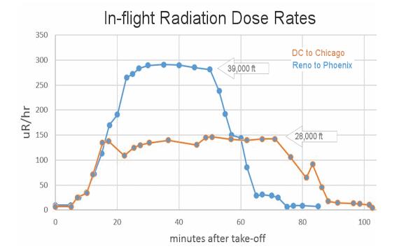
"Regular readers of Spaceweather.com have been following the travels of Tony Phillips, who spent the past week flying commercial jets back and forth across the USA for meetings in Washington DC. In addition to his usual baggage, he carried a pair of radiation sensors onboard. Sitting in the economy section of a US Airways flight from Reno to Phoenix on Nov. 11th, Phillips recorded dose rates which were almost 30 times higher than background dose rates at ground level. On Nov. 15th, he gathered data from a return leg, American Airlines flight 2407 from Washington DC to Chicago. It was only half as bad:"
See more from SpaceWeather.com HERE:
Thanks again for checking in and have a great week ahead! Don't forget to follow me on Twitter @TNelsonWX

No comments:
Post a Comment