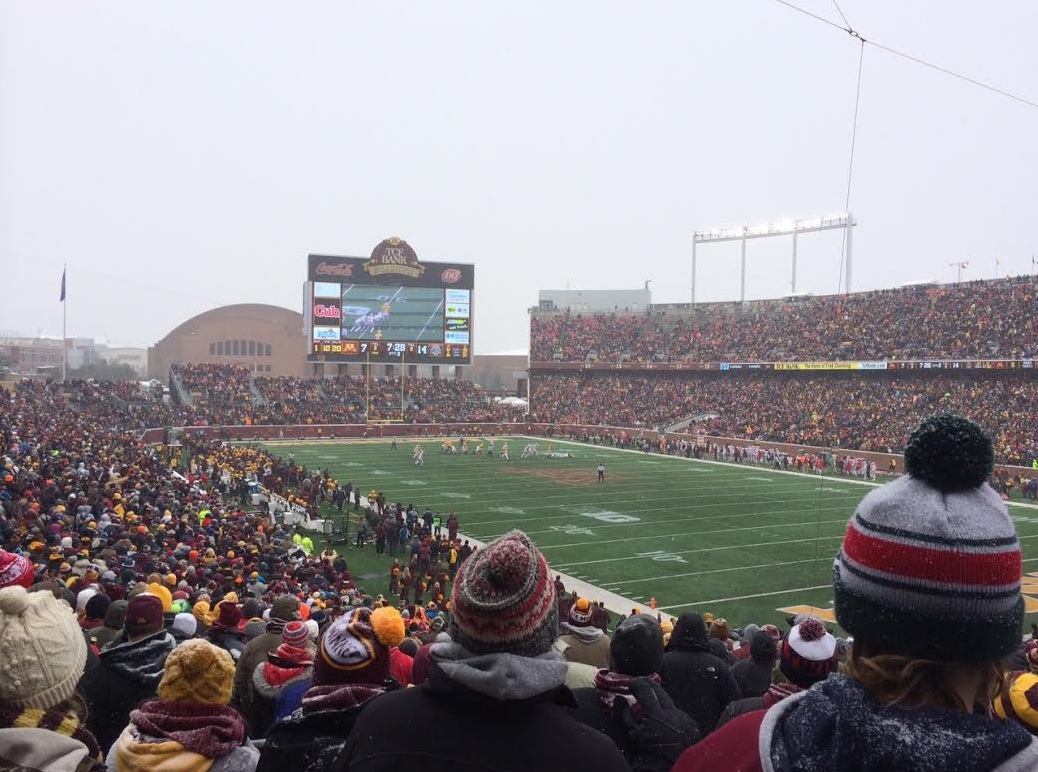
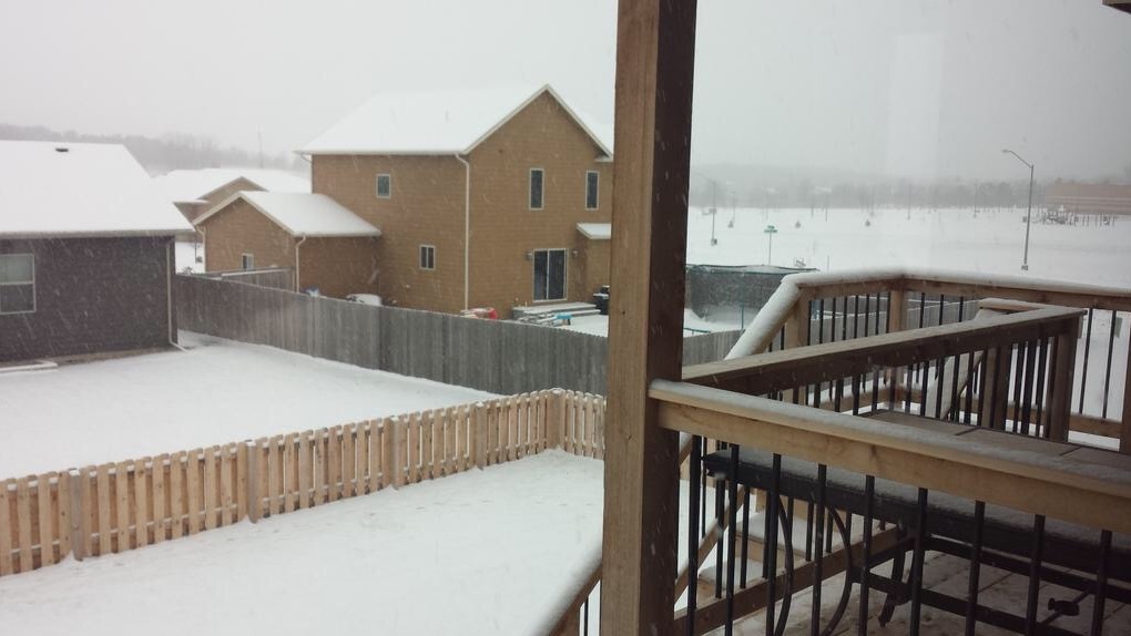
(Photo credit: Aaron Weidner - View from a snowy TCF Bank Stadium during the Gopher game on Saturday.)
Well Preserved
By Paul Douglas
By Paul Douglas
Rationalizing
the benefits of cold weather may be an exercise in futility but
persistent cold may explain why Minnesota has the second longest
life expectancy in the USA, second only to Hawaii.
Cold
weather is a can't-miss weight loss program; your body burns
more calories to stay warm. Much like athletes put ice on an injury,
numbing air helps to reduce inflammation and pain. The cold
kills disease-carrying insects which survive in (milder) states to our
south. Brittle Canadian exhaust also brings us inside and closer
together; human interaction that benefits our mental health. Are
you buying any of this? It was worth a try.
Welcome
to another unnecessarily cold week, a (healthy!) serving of January.
Lobes of unusually cold air rotate into Minnesota today, another
shot Thursday. Highs hold in the teens, daytime windchills dipping below
zero - nighttime lows dipping into negative numbers outside the Twin
Cities. A Fast Forward Winter.
The
atmosphere usually evens things out, cold spells followed by recovery. A
milder Pacific flow kicks in late week and lingers into late November.
Anywhere else in America 30s and 40s would be considered a cold front. Here? Sweet Relief.
==============
SATURDAY NIGHT: Light snow early, then tapering later. Less than 1" of additional snow possible. Low: 9. Winds: SSW 5-10mph
SUNDAY: Mix of sun and clouds, breezy, few flakes possible. High: 19. Winds: SW 10-15mph
SUNDAY NIGHT: Clouds thicken, chance of light snow overnight. Low: 7. Winds: W 10-15mph
MONDAY: Clouds and a few flakes. AM wind chill: -10F. High: 17
TUESDAY: Peeks of sun, cold wind. Wake-up: 3. High: 17
WEDNESDAY: More clouds than sun. Hibernating... Wake-up: 11. High: 23
THURSDAY: Another shot of cold air. Feels like 0F. Wake-up: 10. High: 20
FRIDAY: Partly sunny and breezy. Wake-up: 5. Low: 23.
SATURDAY: Long overdue thaw. Much better! Wake-up: 10. High: 34.
===============
This Day in Weather History
November 16th
November 16th
1933:
Record lows were set in a few locations including Farmington with a low
of 11 degrees below zero, Little Falls at 10 degrees below zero, Chaska
at 9 below and Milaca at 8 degrees below zero.
1931: Tornado near Maple Plain in Hennepin County. Path of storm was five miles long.
===============
Average High/Low for Minneapolis
November 16th
November 16th
Average High: 41F (Record 68F set in 1953)
Average Low: 26F (Record -2F set in 1933)
Average Low: 26F (Record -2F set in 1933)
================
Sunrise/Sunset Times for Minneapolis
November 16th
November 16th
Sunrise: 7:11am
Sunset: 4:43pm
Sunset: 4:43pm
=================
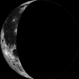
Moon Phase for November 16th at Midnight
2.7 Days After Last Quarter
2.7 Days After Last Quarter
=================
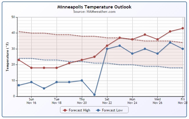
Minneapolis Temperature Trend
Well,
the extended forecast sure looks promising doesn't it? We may finally
climb out of this sub-freezing hole we've been in for the past week.
We've been sub-freezing since late Sunday night November 9th and the
forecast calls for sub-freezing temperatures to continue until maybe
Saturday, November 22nd or Sunday, November 23rd. We may indeed go 13 to
14 straight days with sub-freezing temperatures here in Minneapolis,
which is quite rare for November!
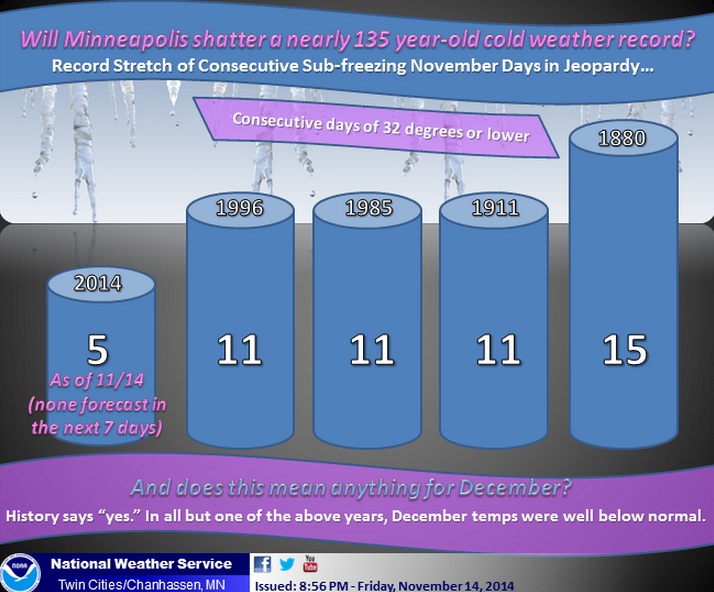
Rare November Cold
Sure,
it can get cold in November, but to have it as cold as it has been for
long... that's pretty rare! In fact, the NWS has dug up some pretty
interesting information regarding November Cold and according to recent
forecasts, we could make it to the 2nd longest stretch of sub-freezing
temperatures in Minneapolis during the month of November!
"Will
the record stretch of consecutive days at 32 degrees or lower during
the month of November be broken? In order for it to happen, it would
have to stay at or below freezing through November 25th..."
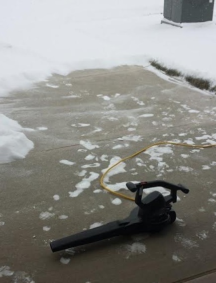
Saturday Snow
Thanks
to my good friend @MatthewDux for the picture below out of Sioux Falls,
SD where a few inches of fluffy snow piled up early Saturday.
Leaf Blower Snow??
The
nice thing about cold weather is that when it snows, it tends to be
very light and fluffy. My good friend Matt told me that it was fluffy
enough to clear with a leaf blower!! LOL - I am going to have to
remember that next time!
Alaskan Warmth
While
much of the Lower 48 endures well below average temperatures, Alaska is
basking in mid November warmth! Anchorage, AK had daytime highs in the
upper 40s several times (a few degrees away from record highs) last
week; average highs in Anchorage, AK at this time of the year is in
the upper 20s.
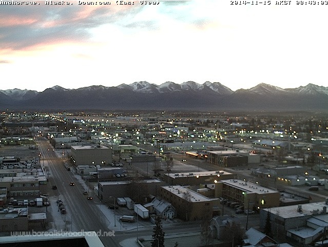
Here's a look at how warm it could be on Sunday!
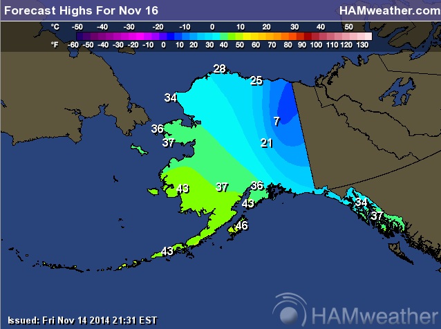
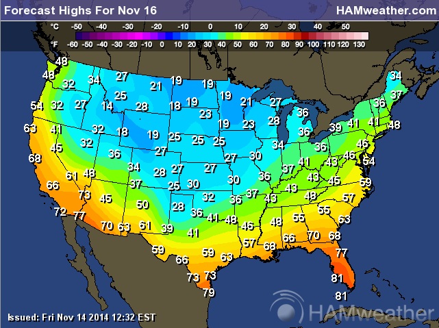
Much Colder Lower 48
Interestingly,
most of the the Lower 48 is MUCH colder than what parts of Alaska are
experiencing now. Forecast highs from the Intermountain West to the
Plains and Great Lakes will stay below freezing for highs on Sunday.
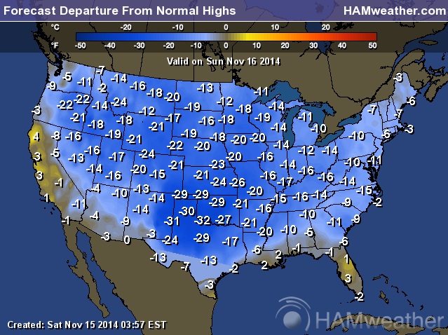
Sunday Highs From Average
Look
at how much colder than average much of the nation will be on Sunday!
Some of the biggest departures from average will be found near the Texas
Panhandle where readings will be nearly 30F below average!
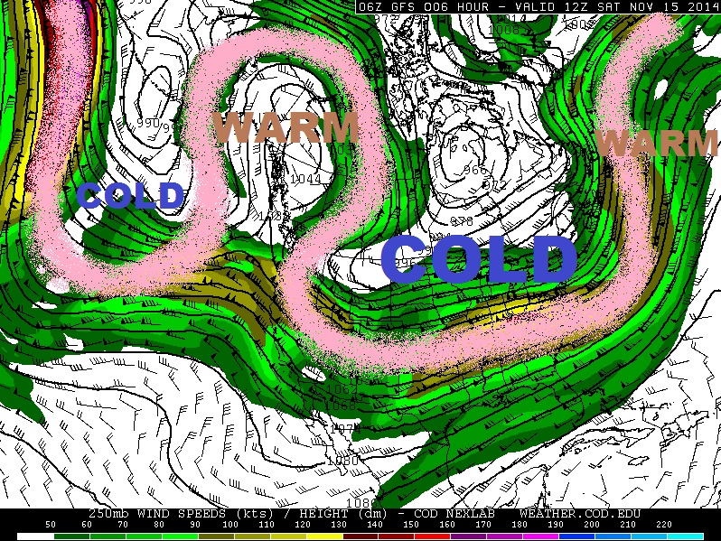
Why So Cold?
The
upper level winds (Jet Stream) reveal the answer behind our recent
(long-lived) cold snap. Note how crazy it looks as it snakes its way
from the northern Pacific Ocean through North America and into the north
Atlantic Ocean. This represents a "High Amplitude" weather pattern, in
which weather systems are nearly stuck and aren't moving very quickly
from west to east. Interestingly, the jet stream got all bent out of
shape in response to Super Typhoon Nuri in the Pacific Ocean that
eventually linked up with the jet stream west of Alaska. This led to a
massive storm system blowing up in the Bering Sea about a week ago,
which ultimately affected the jet stream downstream. Since then, a ridge
of high pressure has been nearly stationary over Alaska keeping things
mild there and farther downstream, a massive trough has developed over
the U.S. allowing for much below average temperatures to persist here.
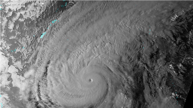
How Super Typhoon Nuri Changed Weather in North America
Have
you ever heard the "Butterfly Effect" phrase?? Chaos Theory suggests
that a butterfly flappings it's wings in New Mexico can cause a
Hurricane in China... Yes, many things can be interrelated, but would
you belive it if I told you a super typhoon that was in the western
Pacific Ocean about 2 weeks ago may be responsible for our recent cold
snap? Take a look at this story from www.Mashable.com
"Heather
M. Archambault, a scientist at the University Corporation for
Atmospheric Research, is an expert on the complex atmospheric feedbacks
between recurving typhoons like Nuri, and the jet stream that runs from
above the North Pacific toward North America. These feedbacks have only
been identified in the past few years, having existed as hunches in the
minds of forecasters before that.
Archambault,
who currently is based at the National Oceanic and Atmospheric
Administration in Maryland, wrote her 2011 doctoral dissertation on the
topic while at the State University of New York at Albany. She
told Mashable in an interview that Typhoon Nuri is a classic case in
which a recurving storm in the Northwest Pacific energizes the jet
stream and results in a faster and wavier upper air flow, and hence
stormier conditions, thousands of miles downstream. Recurving refers to a
directional change in the path of the storm, in this case from an
original bearing of west/northwest, to its current past of northeast.
Archambault
says that recurving typhoons like Nuri “increase the chance of having
extreme weather across North America” about three to five days later,
because the air flowing out of the typhoon gets funneled into the North
Pacific jet stream. This adds energy to the jet, which “perturbs” it,
she says."
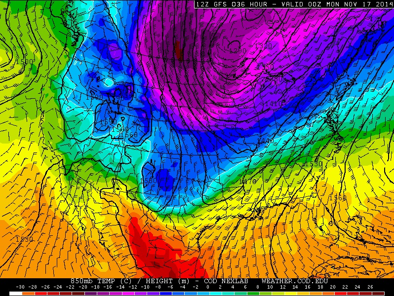
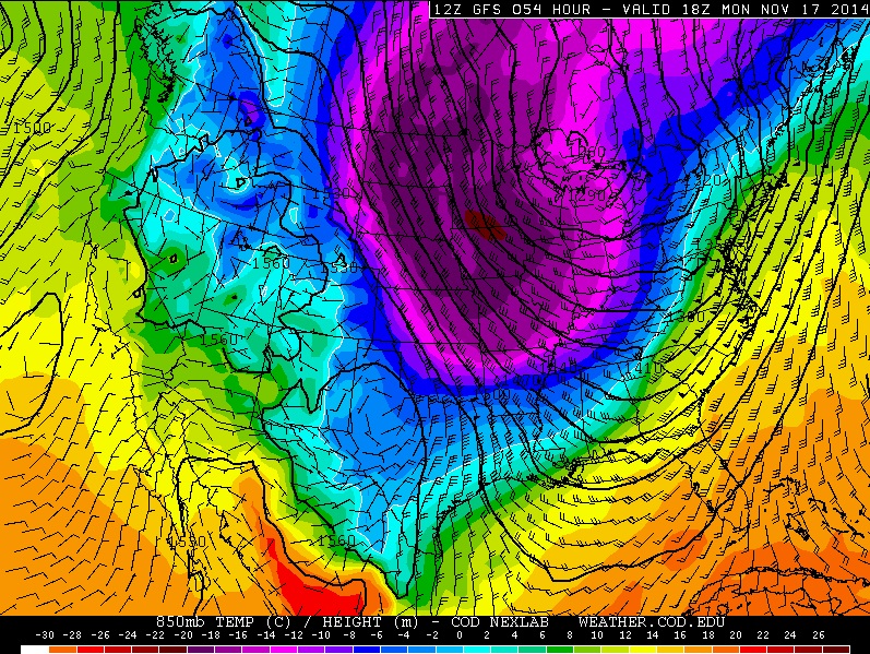
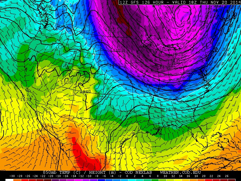
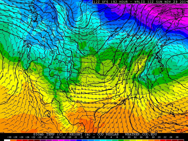
Continued Cold Until Next Weekend
Extended
weather models continue to suggests cold conditions sticking around
through the week ahead, but there may be a little light at the end of
the cold tunnel. The maps below show temperatures a few thousand feet
off the ground over the next 7 days. Note the warmer colors FINALLY
moving back in by next weekend.
Sunday, November 16th
Monday, November 17th
Thursday, November 20th
Sunday, November 23rd
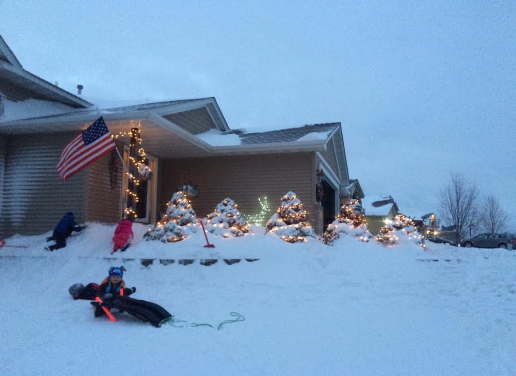
Jumping the Gun?
With
the recent cold and snowy weather... I am in full blown holiday spirit.
I have been getting a lot of weird looks from my wife. "Todd, don't you
think you're jumping the gun a little on the Christmas lights and
music?" I suppose, maybe. But, I know a few folks already have their
Christmas tree up and I haven't gone that far! After all, the weather
made me do it!
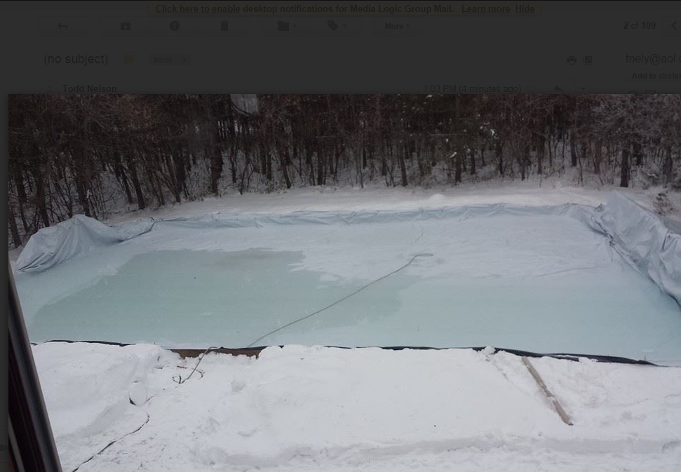
Jumping the Gun Continued...
Thanks
to my good friend Jimmy Deschene for the picture below who may be
taking a chance on getting the backyard rink ready for the winter. Sure,
it's cold enough for ice making now, but the upcoming weekend looks
warm enough to melt it again. Keep in mind that our average high at this
time of the year is still 41F !! We've been nearly 20F to 30F below
average for several days. These temperatures are more typical of
January, not November! Our average high doesn't drop below freezing
until the first week of December. Let me know when you get Ice Jimmy! I
can't wait to lace up my skates on outdoor ice!
Jumping the Gun Continued...
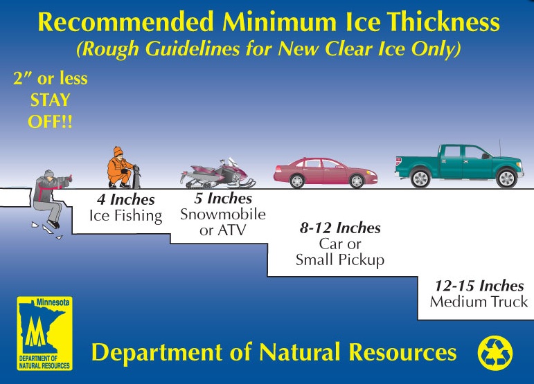
On
a more serious note, I have been hearing reports of some folks doing a
little ice fishing on area lakes! YIKES!!! MAKE SURE THERE IS ENOUGH
ICE!!!! Keep in mind that a MINIMUM of 4" is needed for ice fishing! I
don't know where we're at in terms of ice thickness on area lakes, but I
would assume it's not much since we've only had a FEW days of this cold
weather!! And remember that ice is NEVER 100% safe!!
Hard Water Ice Fishing Expo
If
you're looking for something to do this weekend, check out the Hard
Water Ice Fishing Expo at the National Sports Center in Blaine. The cold
and snowy weather has a lot of people chomping at the bit. This may
help mitigate your ice fishing cravings.

Thanks for checking in and have a great rest of your weekend! Don't forget to follow me on Twitter @TNelsonWX

No comments:
Post a Comment