By Paul Douglas
"Paul, it's COLD outside. Global warming is a joke and so are you!" I wish my wife would stop e-mailing me at work. Look, Sarah Palin can see Russia from her house, but I can't look out my window and see global temperatures. That's why we have - wait for it - climate scientists! October was the warmest, worldwide, since 1880, according to NASA GISS. There's a high probability 2014 will be the warmest year on record, warmer than 2010, the previous all-time record, in spite of a lack of an El Nino warm phase in the Pacific. Resist the urge to gaze out the window and make global assumptions.
When it's this cold it doesn't take much upward motion to squeeze out a few inches of fluff - there's more air between the flakes, like the feathers in a down comforter. 1 to 3 inches of powder may accumulate Saturday, the only accumulating snow in sight. A reinforcing jab of numbing air drifts over Minnesota Monday - highs holding in the teens early next week before slowly recovering.
We should reach the 30s next weekend - the atmosphere warm enough for 40s with a chance of a some rain Thanksgiving week. You remember rain, right? A swing back to "average" is likely, overdue & welcome.
============================
FRIDAY NIGHT: Clouds increase. Low: 5. Winds: W 5mph
SATURDAY: Light snow developing. 1-3" snow possible. Best chance of icy roads over southern Minnesota. High: 22. Winds: SSE 5mph
SATURDAY NIGHT: Light snow early, then tapering later. Less than 1" possible. Low: 11. Winds: SSW 5-10mph
SUNDAY: Mostly cloudy, breezy, few flakes in the air. High: 21. Winds: SW 10-15mph
MONDAY: Clouds and a few flakes. AM wind chill: -10F. Wake-up: 7. High: 17
TUESDAY: Partly sunny, cold breeze. Wake-up: 4. High: 21
WEDNESDAY: Some sun, not as harsh. Wake-up: 12. High: 26
THURSDAY: Plenty of sun, dripping icicles. Wake-up: 10. High: 23
FRIDAY: Clouds increase, not as numb. 17. Low: 29.
============================
Today in Weather History
November 15th
1976: So far this year there had been over three thousand forest fires in Minnesota.
===========================
Average High/Low for Minneapolis
November 15th
Average High: 41F (Record: 69F Set in 1953)
Average Low: 27F (Record: 1F set in 1940)
============================
Sunrise/Sunset Times for Minneapolis
November 15th
Sunrise: 7:10am
Sunset: 4:44pm
============================
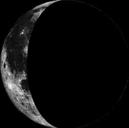
Moon Phase for November 15th at Midnight
1.7 Days After Last Quarter
=============================
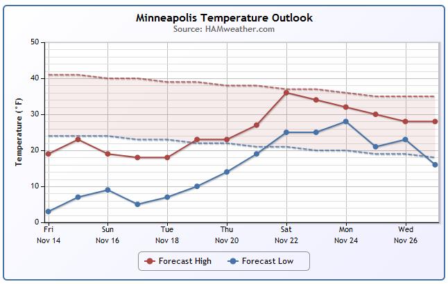
Minneapolis Temperature Trend
Ahh - I think there might be a little light at the end of the cold tunnel. Extended model runs are suggesting a fairly modest warmup by next weekend! We may actually get close to average! In the meantime, we stay WELL below average temps until the end of next week.
======================
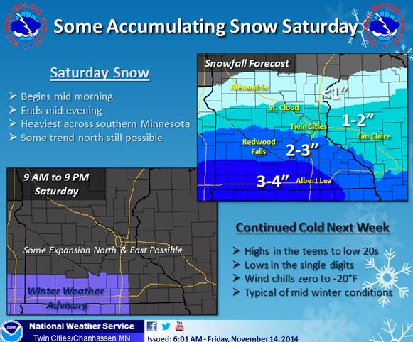
Saturday Weather Outlook
One of the big weather stories on Saturday will be the snow potential, but another will be the continued cold temperatures. Highs on Saturday will only reach the teens and 20s across the state, but it'll feel more like the single digits and teens for much of the day with a little breeze out of the S/SW.
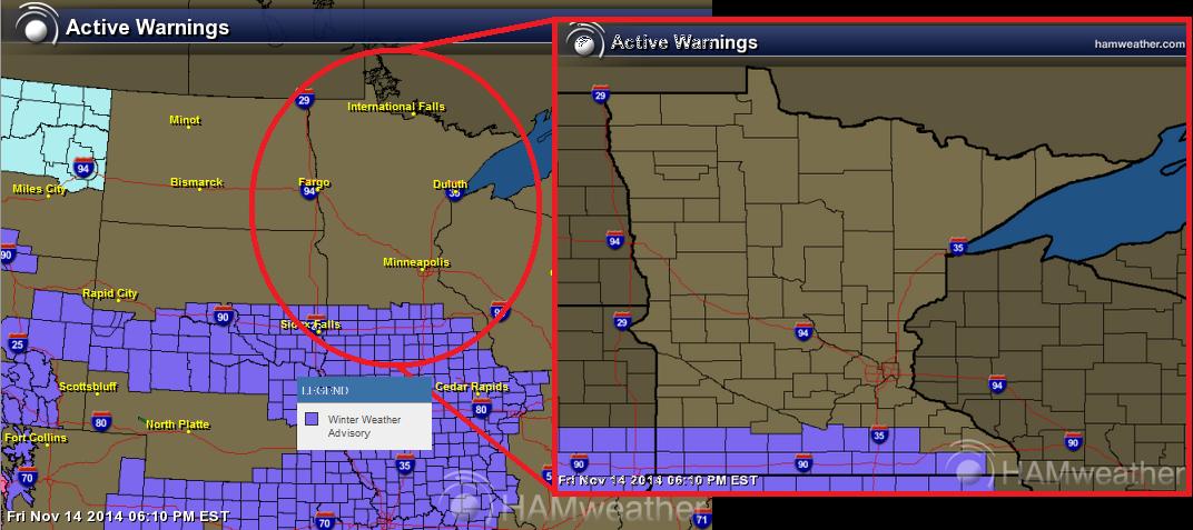
Winter Weather Advisory
The extreme southern part of Minnesota is under a Winter Weather Advisory from 9am Saturday to 9pm Saturday... Here are the details:
...WINTER WEATHER ADVISORY REMAINS IN EFFECT FROM 9 AM TO 9 PM CST SATURDAY...
A WINTER WEATHER ADVISORY REMAINS IN EFFECT FROM 9 AM TO 9 PM CST SATURDAY.
* TIMING...SNOW WILL BEGIN AROUND MID MORNING SATURDAY AND TAPER OFF BY MID EVENING.
* SNOW ACCUMULATION...3 TO 4 INCHES.
* IMPACTS...TRAVEL MAY BECOME DIFFICULT SATURDAY AFTERNOON AS ROADS BECOME SNOW COVERED AND SLICK...ESPECIALLY ALONG THE INTERSTATE 90 CORRIDOR.
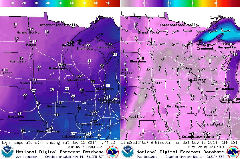
Saturday Snow Potential
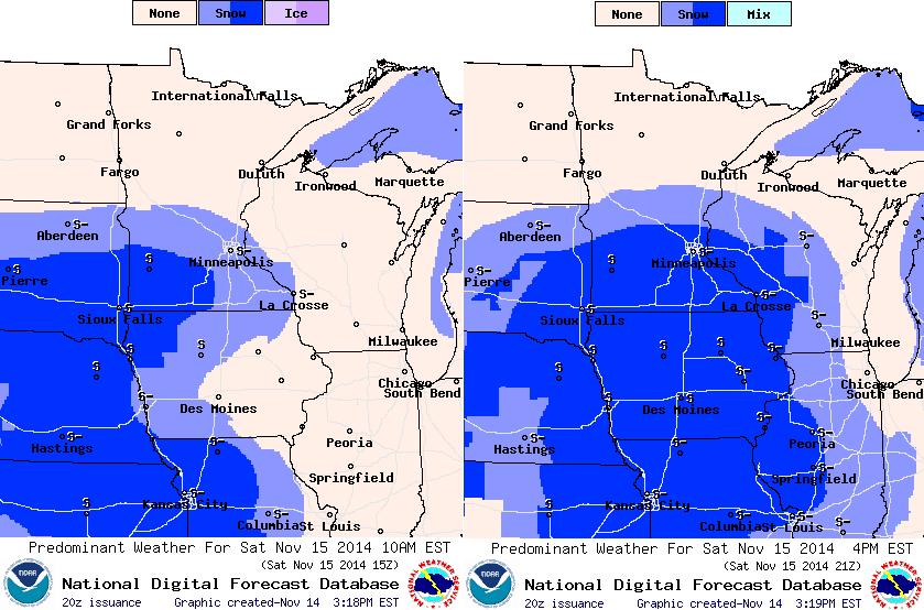
A light snow event will unfold through the day Saturday, mainly across southern MN. Keep in mind that with temperatures as cold as they are, this snow will be quite fluffy and should accumulate fairly easily across the southern half of the state. The heaviest, though, will be in extreme southern MN, while the Twin Cities could see 1" to 3" - higher end of that scale in the south/southwest metro, while the lighter end of that scale will be found across the northern part of the metro. The images below show the snow potential at 9am (left) and at 3pm (right).
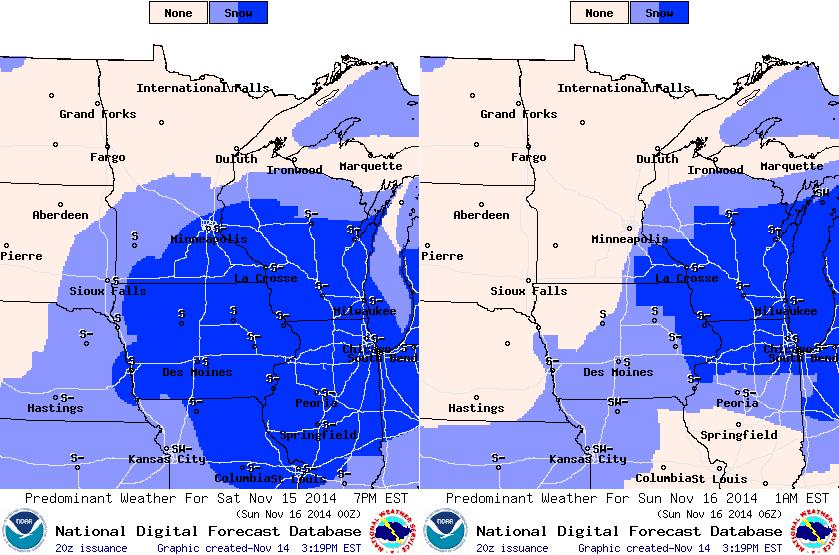
The images below show the snow potential at 6pm (left) and at 12am Saturday (right).
Saturday Snow Potential
Here's a look at the snow potential from the National Weather Service...
"Snow will push into southern Minnesota during the mid-morning hours Saturday and continue through mid-evening. A few inches are expected along I-90, with amounts tapering off to the north."
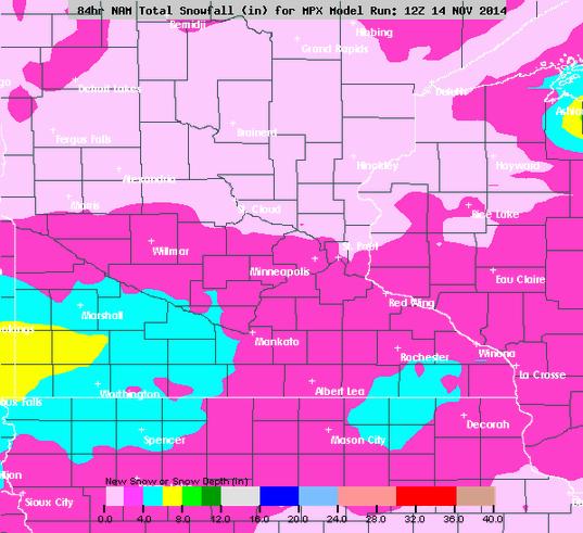
Saturday Snow Potential
According to the NAM, Saturday's snowfall solution shows more snow across southern and southwestern Minnesota vs. what the Twin Cities and central Minnesota will see.
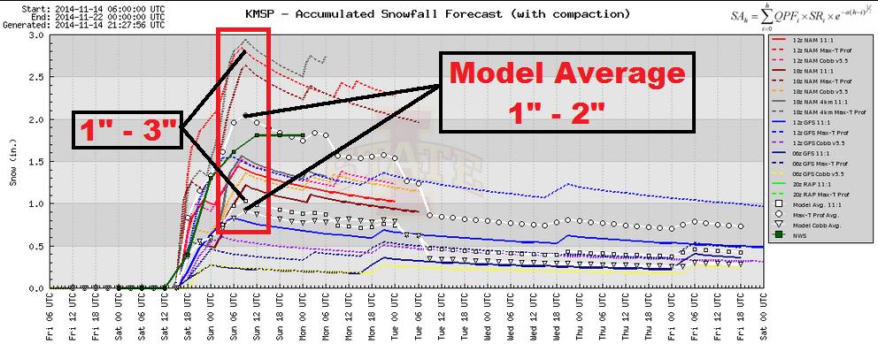
Saturday Snow Potential Continued...
Here's a look at several different model solutions for Minneapolis. As of Friday, model solutions ranged from 1" to 3" while the model average was around 1" to 2" of fluffy snow.
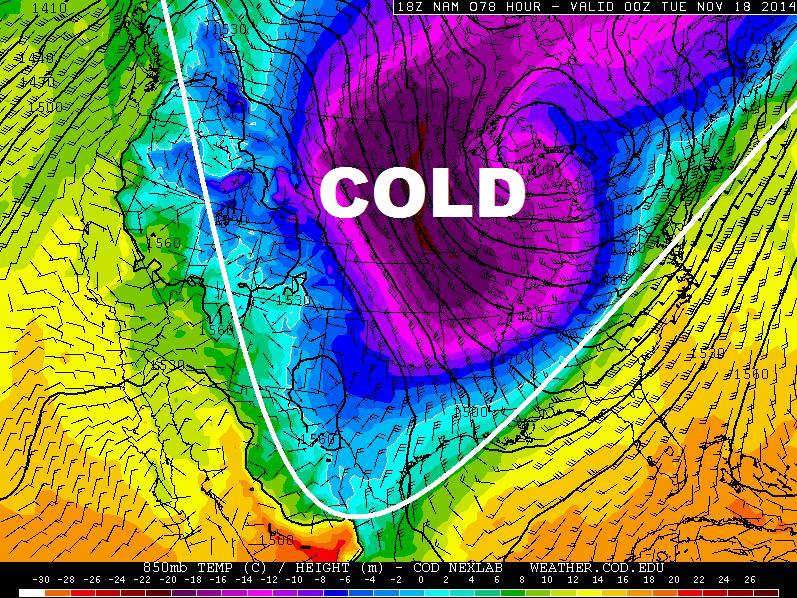
Continued Cold
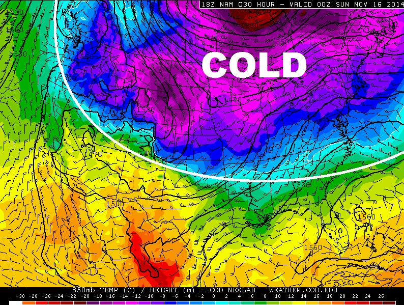
The current cold air mass that is taking up residence across much of the nation looks like it'll stick around for quite a few more days... It's not all that unusual to see cold air at this time of the year, but to have it widespread and for as long of duration, that's rare!
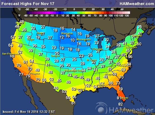
Cold Monday
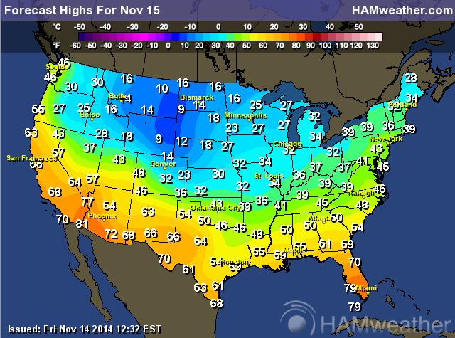
Here's a look at expected high temperatures for Saturday...
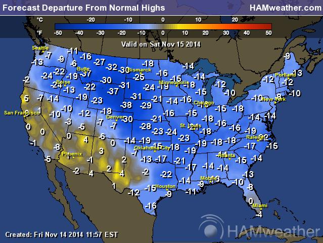
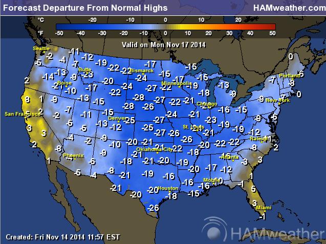
Highs From Average Saturday
WOW! Temperatures across the nation will be nearly 10F to 40F below average!!
Cold Temperatures Continue Monday
It appears that another lobe of even colder air will blast through the mid-section of the nation during the early part of next week. This airmass will also have wide reaching effects, even into portions of southern Texas and northern Mexico!
Highs Monday
Here's Monday's forecast high temperatures.
Highs From Average Monday
Here's how much colder than average Monday's high temperatures will be. Note the near 20F below average readings in Texas!
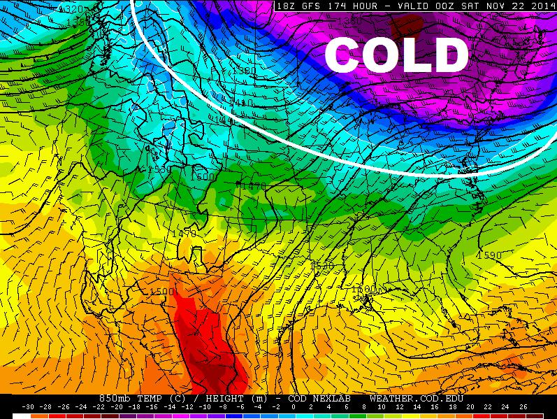
Moderating End of Next Week
The good news is that the core of the extreme cold looks to be retreating a bit by the end of next week. It'll still be chilly, but there will be some warmth returning back to the lower tier of the U.S..
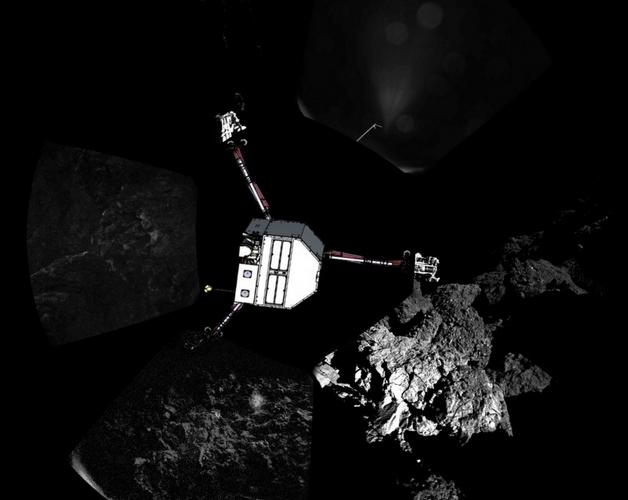
Comet Lander
"Mission controllers for ESA's Rosetta spacecraft have figured out where Philae landed on the surface of Comet 67P, and it's not good news. The lander appears to have bounced down in the shadow of a tall cliff. With little sunlight to draw upon, the lander's solar-powered batteries could run out of juice as early as this weekend, cutting short an unprecedented mission of discovery. European engineers are working rapidly to come up with a solution. Wish them luck and stay tuned."
Find out more about the Comet Lander HERE:
Thanks for checking in and have a great weekend ahead! Don't forget to follow me on Twitter @TNelsonWX

No comments:
Post a Comment