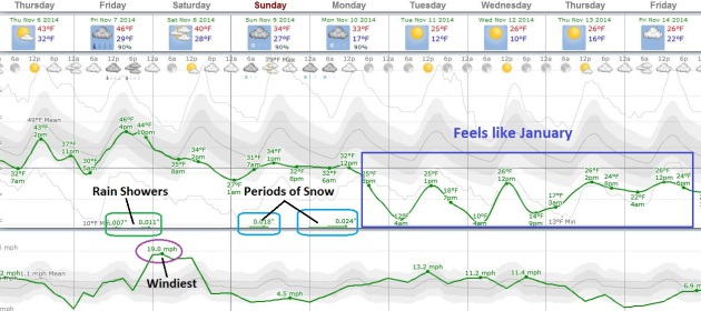
45 F. high in the Twin Cities Wednesday.
48 F. average high on November 5.
45 F. high on November 5, 2013.
.02" rain fell as of 7 pm yesterday.
Goosebump Alert
At
some point the law of physics catches up with you: the tilt of the
Earth on its axis, long nights, only a glancing blow of sunlight during
the day. Rapid cooling ensues, the southward advance of these dollops of
chill spinning up rain, then a rain-snow mix, then all-snow when
temperatures in the lowest mile of the atmosphere are consistently below
freezing.
Minnesota may fast-forward through all these stages in
the coming days. By Monday you may want to have your snow tires
installed, your driveway staked, a trusty ice-scraper in the glove
compartment. Gloves might be nice too, since wind chills next week will
dip to single digits at times. Perfectly normal, for January.
A
little snow fell up north overnight and after a damp, gray start skies
clear later today. Light rain & snow tracks across northern
Minnesota Friday, followed by an even colder clipper. Highs on Saturday
may hold in the 30s. Time to dig out the parkas.
Snowy rumors are
lighting up the Twitter-sphere, and it's still ripe for some snow
Monday, as the core of this next cold shot arrives.
It's too early
for specifics but rain may end as 1-2 inches of slush late Monday. Not
exactly the end of the world. Just November.
Into The Deep End.
So much for tip-toeing into winter. We get pushed into the deep end of
the pool next week, with daytime highs pretty much stuck in the 20s and
low 30s Monday into Friday; lows in the teens with some single-digit
wind chills at times. Perfectly average for mid-January, but coming a
little early this year. Payback for all those 60s and 70s last month.
The atmosphere should be mild enough for rain showers Friday; a little
snow is possible Sunday, again Monday as much colder air approaches. The
greatest potential for an inch or two of slush may come late Monday and
Monday night.
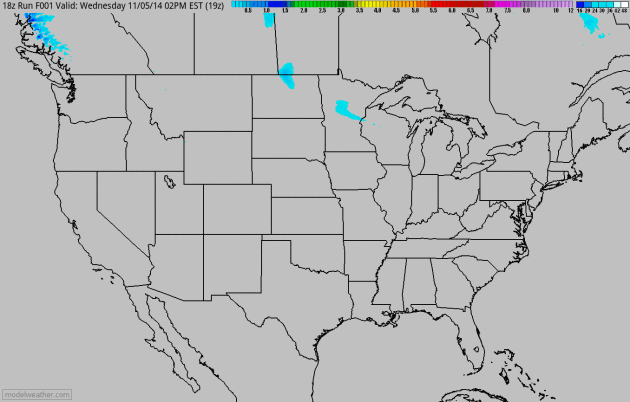
60-Hour Snowfall Potential.
NOAA's 4 km NAM accumulated snow product shows today's clipper pushing a
little snow into Wisconsin; lake effect snow bands setting up downwind
of Erie and Ontario within 48 hours as a very cold fetch passes over
relatively mild lake water. Loop: HAMweather.
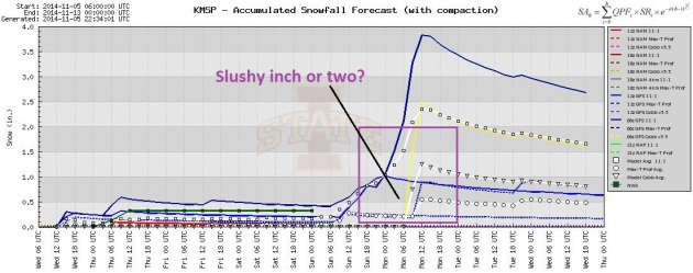
Monday Slush Event?
Right now it does not look like a knock-down, drag-out snowstorm, but
we usually wind up with some accumulation when temperatures drop off
this rapidly. The best chance of a slushy inch or two of accumulation
comes Monday afternoon into the early nighttime hours. I could see some
travel headaches late Monday, again Tuesday morning for rush hour.
Source: Iowa State.
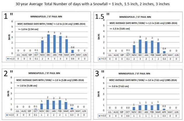
About 16 Days With An Inch or More of Snow Every Winter.
That's during an "average winter", which of course is a made-up
statistic that never quite materializes as we swing from one extreme to
the next. Data above based on the 30-year averages; more information
here, courtesy of
NOAA in the Twin Cities.
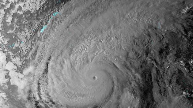
How Typhoon Nuri Is Changing The Weather Forecast in North America.
Ex-typhoons in the Pacific that recurve to the northeast can have a
profound impact on North American weather 3-5 days later, according to
recent research. Here's an excerpt of a good summary at
Mashable: "...
She
told Mashable in an interview that Typhoon Nuri (as of Tuesday morning
it's no longer a super typhoon) is a classic case in which a recurving
storm in the Northwest Pacific energizes the jet stream and results in a
faster and wavier upper air flow, and hence stormier conditions,
thousands of miles downstream. Recurving refers to a directional change
in the path of the storm, in this case from an original bearing of
west/northwest, to its current past of northeast. Archambault says that
recurving typhoons like Nuri “increase the chance of having extreme
weather across North America” about three to five days later, because
the air flowing out of the typhoon gets funneled into the North Pacific
jet stream. This adds energy to the jet, which “perturbs” it, she says..."
Image credit above: "
Super Typhoon Nuri seen at night via the VIIRS imager on board the Suomi NPP satellite." Image: University of Wisconsin/CIMSS.
 The Break-Off Effect
.
What happens to the human brain at the upper reaches of the
troposphere, where all "weather" takes place? Some handle it better than
others. And for some it's a nothing short of a religious experience.
Here's an excerpt of a fascinating story at
Fast Company: "...
Higher
than that, at roughly 70,000 feet, some pilots and engineers say you
can grasp the curvature of the earth. Strange things have happened to
the human mind at those heights. A year after the commander reported his
symptoms, a Navy medical officer and a psychologist published a study
on a dissociative anomaly pilots experienced while flying at high
altitudes. Brant Clark and Captain Ashton Graybiel interviewed 137 Navy
and Marine pilots who had come up with a term for it themselves. The
“break-off" phenomenon, they called it..." (Image: NASA).
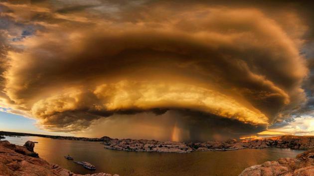
A Photo That Left Me Speechless. This has to be one of the most remarkable examples of a supercell thunderstorm I've ever seen, courtesy of
Bob Larson Photography. Bob writes via Facebook: "
I'm
the photographer that took this picture and just to clear some things
up. This is a series of 16 shots taken with a wide angle lens in order
to fit in the entire storm. The shots were taken on Oct 9, 2014 at 6:42
pm. The location is Willow Lake in Prescott, Arizona, not Watson Lake as
many people seem to have assumed. They were taken from the top of a
Granite cliff. The storm was very real and there are about a bajillion
other photos of this storm from many other photographers posted on the
internet and in our local newspaper. I have many other shots from that
evening on my website and facebook page if you're interested."
Election 2014 By The Numbers.
I'm not sure what to do with myself now that I can't enjoy 24/7
negative political ads on TV and radio. For a staggering list of numbers
and factoids related to the 2014 midterm elections check out this
article from
The Center for Public Integrity. Here's an excerpt that made my eyes water:
Estimated number of TV ads aired through late October targeting U.S. Senate elections: 908,000
Number of states where a Senate-focused TV ad in late October appeared, on average, at least once every two minutes: 8..."
TODAY: Early mix, slow PM clearing. Winds: NW 15. High: 43
THURSDAY NIGHT: Partly cloudy and chilly. Low: 30
FRIDAY: Cloudy, showers up north. High: 49
SATURDAY: Clearing skies, cold wind. Wake-up: 34. High: 39
SUNDAY: Mostly cloudy. Light mix possible, wet roads. Wake-up: 28. High: 41
MONDAY: Rain ends as snow. Slush potential. Wake-up: 32. High: 39
TUESDAY: Hello January. Feels like 10F. More clouds than sun. Wake-up: 19. High: 26
WEDNESDAY: Sunny, still partially numb. Wake-up: 19. High: 29
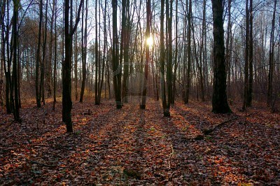
* Photo above courtesy of
Steve Burns Photography.
Climate Stories...
The Biggest Loser In This Election is the Climate.
Vox takes a look; here's an excerpt: "...
In
the short term, the election's impact might seem negligible. After all,
the action in Washington over the next few years will center on the
Environmental Protection Agency, which is crafting rules
to cut carbon-dioxide emissions from US power plants. These rules don't
need congressional approval (they're being done under the existing
Clean Air Act), and President Obama is expected to veto any attempts by
Congress to block them. But congressional indifference is a huge problem
for future climate policy. The most recent report from the
Intergovernmental Panel on Climate Change warned that global
greenhouse-gas emissions need to fall 42 to 71 percent below 2010 levels
by mid-century if we wanted to fend off the worst impacts of global
warming and prevent average temperatures rising more than 2°C (or
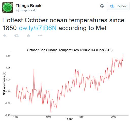
3.6°F)..." (Image: USGS/Flickr).
Ever More Cities Divesting From Fossil Fuels. Here's a clip from
Deutsche Welle: "...
Since
it began on US university campuses in 2011, Fossil Free has spread to
New Zealand, Australia and - last year - to Europe, with cities, towns,
religious institutions, universities, and recently the heirs to Rockefeller oil fortune all pledging to divest from fossil fuels. The group behind the movement, 350.org,
says its aim in encouraging and supporting local divestment campaigns
is to raise awareness about the role of coal and oil in fueling climate
change, and make investment in fossil fuels socially unacceptable..."
Shell Executives Get Slammed At Their Own Climate Change Conference.
Quartz has the story, including an excerpt of the keynote speaker's opening remarks: "...
Environmentalist
Bill McKibben, the conference’s keynote speaker, used his time at the
podium to ream out the event’s unlikely corporate sponsors:
I
didn’t know Shell was sponsoring this conference when I agreed to do
it, but I’m glad for the chance to say in public that Shell is among the
most irresponsible companies on earth. When they write the history of
our time, the fact that Shell executives watched the Arctic melt and
then led the rush to go drill for oil in that thawing north will provide
the iconic example of the shortsighted greed that marks the richest
people on our planet.


No comments:
Post a Comment