39 F. high in the Twin Cities Sunday.
45 F. average high on November 9.
46 F. high on November 9, 2013.
National Weather Service Historical Data for November 9:
1999:
Late season hail fell in Eden Prairie. Pea size hail (0.25 inch. in
diameter) up to one foot deep collected near storm drains near Hennepin
Technical College and Hwy 212. Pea size hail about 4 inches deep was
also reported on grass near Hwy 5 and Mitchell Rd. The hail and
torrential rains forced drivers off the road in Bloomington.
1998:
A potent storm nick-named a "land hurricane" set a new all time record
low pressure for Minnesota around noon at Albert Lea and Austin as it
passed overhead. The automated weather observing equipment at both
airports measured a barometric pressure of 28.43 inches, which broke the
previous record of 28.55 inches set on 11 January 1975 in Duluth. The
new record for the Twin Cities was set with a reading of 28.55 inches.
The previous record was 28.77 inches, set on April 13th of 1964. 10
inches of snow fell at Madison, MN and St. Cloud State University had a
wind gust to 64 mph.
1975: The Edmund Fitzgerald sinks off Whitefish Bay with the loss of 29 people.
1913: A severe windstorm occurred on Lake Superior. Three ships were lost. Winds were clocked at 62 mph at Duluth.
Very Plowable
We
usually get a little warning: an October coating of slush, a fistful of
flurries around Halloween? Not this year. We'll go from dull-green
lawns to a snowy Currier and Ives landscape, in a blink of an eye. No
easing into winter this year.
There's no intense storm to track,
rather an extended period of light to moderate snow, as warm glides up
and over a sharp temperature boundary. With temperatures consistently
below freezing in the lowest mile of the atmosphere I expect all snow
from the Twin Cities on north. Roads will go from slushy to icy to
treacherous by tonight as the mercury drops through the 20s. Rush hour
tomorrow morning will be anything but.
How much in my yard, Paul?
Please be specific! Odds still favor a healthy pile of white, enough to
shovel and plow. I expect most suburbs to pick up 5-10 inches by Tuesday
morning; a better chance of a cool foot from St. Cloud into the
northern suburbs of the Twin Cities but less snow south of the Minnesota
River, where ice may mix in for a time.
Travel should improve during the day Tuesday but highs in the 20s this week will keep roads icy.
Snow
lovers will celebrate an early January the next 2 weeks - but
long-range models hint at a Thanksgiving thaw. That said, the maps very
much look like the dead of winter. Payback for a supernaturally nice
autumn?
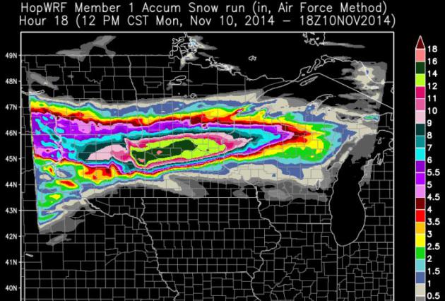
Heaviest Snow Band Just North/West of MSP.
The best chance of a foot to as much as 15-18" snow comes from near
Montevideo and Canby to Willmar and St. Cloud; a foot of snow possible
for northern suburbs. Look at the snowfall gradient across the metro; it
literally goes from a foot near Elk River to 2-3" near Shakopee and
Woodbury. The farther north you travel across the Twin Cities metro the
heavier (and deeper) the snow will be today and tonight. Credit: HopWRF model.
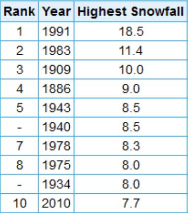
Largest 24-Hour Snowfalls in November.
It will be hard to top November 1, 1991, when 18.5" of snow fell in one
day, during the 3-day snow blitz known as the Halloween Superstorm. If
we pick up at least 7.7" of snow at MSP International this would be a
top 10 November snowfall. Very possible, although the official snowfall
total will be at the airport, where amounts will be less than the
northern suburbs. Graphic:
NOAA.
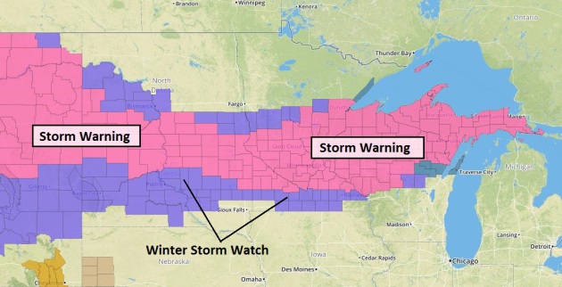
Winter Storm Warnings.
The National Weather Service has most of central Minnesota, and the
northern half of Wisconsin under a Winter Storm Warning, which basically
means treacherous travel is imminent. Plan on it. Ice will mix in over
far southern Minnesota, keeping snowfall totals lower from Mankato to
Red Wing and Rochester. Map: HAMweather.
Sharp Snowfall Gradient Across the MSP Metro.
Latest guidance suggests that the heaviest snow bands may set up from
near Alexandria and St. Cloud to Mora, Cambridge, Princeton and Taylors
Falls, where some 12-16" snowfall totals are possible by Tuesday
morning. Metro amounts may range from 4-5" southern suburbs to 8-10"
northern suburbs, closer to a foot from near Elk River to Ham Lake, in
northern Anoka County. 4 km NAM snowfall totals: NOAA and HAMweather.
Old Man Winter High-Fives Upper Midwest.
That's just a theory, my sorry attempt at positive spin. Think of all
the snow lovers, kids of all ages, snowplow operators and snowmobile
distributors who are giddy with excitement today! Commuters? Not so
much, but winter happens - we just have to deal with it. A premature
shot of January-like air sets off a carpet of plowable snow from the
Dakotas into Wisconsin and the U.P. of Michigan. No travel problems for
Chicago or Detroit from this system.
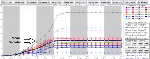
Model Plume.
Data from NOAA SPC shows the ensemble mean around 10" of snow, which I
think will verify over the northern suburbs, but probably not over the
south metro, including MSP International Airport, where the official
snowfall records are kept. There snowfall totals may be closer to 4-5"
by Tuesday morning, still plowable, but not as extreme as 30-50 miles
north of Minneapolis and St. Paul.
More Models.
So much data, a firehose of model simulations - so little wisdom.
Again, look at the trends over time, look for converging model
solutions. I don't think the downtowns or southern suburbs will wind up
with 12-15" snowfall totals, although far northern suburbs could pick up
that much.
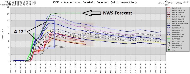
Tracking Model Trends.
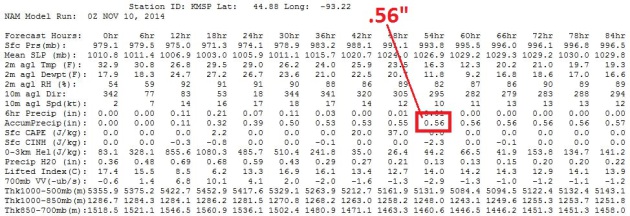
Saturday evening the NAM model was printing out 1.5" liquid. Sunday
morning that dropped to about 1.1" liquid, and then yesterday evening's
model run dropped the total at MSP International to .56", which would
translate into 5-6" snow. The models seem to be trending toward the
heaviest snow bands setting up just north of the downtowns; the axis of
heaviest snow Alexandria to St. Cloud into the far northern suburbs of
the Twin Cities. This still looks (very) plowable, I just don't think
most of us will pick up a foot of snow.
The Calmness Within. Staying calm today and tomorrow will take extra effort. Here's a favorite photo, courtesy of Brandi Shields at
EyeEm.
The Facebook Election.
Will the kind of engagement and personalization possible with Facebook
(and other platforms) eclipse television as the most effective way to
reach voters? As long as I can see the same (bad) negative attack ads.
Please don't take those away.
Buzzfeed has an interesting story; here's a clip: "...
Facebook
is on the cusp — and I suspect 2016 will be the year this becomes clear
— of replacing television advertising as the place where American
elections are fought and won. The vast new network of some 185 million
Americans opens the possibility, for instance, of a congressional
candidate gaining traction without the expense of television, and of an
inexpensive new viral populism. The way people share will shape the
outcome of the presidential election..."
TODAY: Winter Storm Warning. Snow likely. Travel becomes increasingly difficult. High: 31
MONDAY NIGHT: Moderate snow - treacherous travel with icy, snow-covered roads. Low: 26
TUESDAY: Snow tapers by midday; 5-10" totals, more north. Icy roads. High: 28
WEDNESDAY: Welcome to the tundra. Sunny peeks. Wake-up: 9. High: 22
THURSDAY: Mostly cloudy, feels like 10F. Wake-up: 10. High: 27
FRIDAY: Partly sunny. Enjoying January! Wake-up: 12. High: 23
SATURDAY: More clouds than sun, still chilly. Wake-up: 10. High: 28
SUNDAY: Mostly gray, no sign of November yet. Wake-up: 7. High: 22
Climate Stories...
Conservatives Don't Hate Climate Change; They Hate The Proposed Solutions: Study. Huffington Post has the story; here's the intro: "
Conservatives who reject the science of climate change aren't necessarily reacting to the science, according to a new study from researchers at Duke University.
They're reacting to the fact that they don't like proposed solutions
more strongly identified with liberals. The paper looks at the
relationship between political ideology and rejection of scientific
evidence. The researchers look most closely at climate change and other
environmental challenges, an area where
those who identify as liberals or Democrats mostly accept scientific
conclusions while conservatives or Republicans largely reject them. The
researchers conclude that on climate and other important societal
issues, this denial is "rooted not in a fear of the general problem, per
se, but rather in fear of the specific solutions associated with that
problem..."
Climate Conflict Is Near, Admiral Warns.
U-T San Diego has the story; here's an excerpt: "...
But
land, fresh water and other essentials are at risk from the projected
effects of climate change, he said. The U.S. will see conflicts over
those assets unless we convert to clean energy, curb waste and prepare
for long-term challenges, he said. “Sea level is rising, population is
exploding, climates are changing, environments are being affected, and
the potential for a secure and prosperous 21st century is at risk if we
don’t start making some plans for opportunities that are not secured in
the next quarter’s return on investment and the next election,” Hering
said in an interview in advance of his presentation. “We need to make
investments for our grandchildren...” (Image: NOAA).


No comments:
Post a Comment