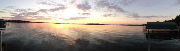
46 F. average high on November 8.
47 F. high on November 8, 2013.
No snow reported at MSP International Airport as of November 8.
November 8 in Minnesota Weather History:
2003: Parts of west central and north central Minnesota received anywhere from 2 to 6 inches of new snow. Canby had the most at 6 inches and Benson measured 5 inches.
1977: A foot of snow falls in Western Minnesota. I-94 is tied up.
1850: The sky darkened at Ft. Snelling due to prairie fires.
Novemb-uary
I just staked my driveway, checked the inflation of my tires, threw an ice-scraper in the trunk. Here we go. September was pleasant, much of October was a dream. Now we skip 2 months and head right to January.
Sadly, I'm not exaggerating. The next two weeks will run 20-30F colder than average: a giant ice cream scoop of polar pain making a few passes at the USA - each jolt of cold air spinning up a new storm.
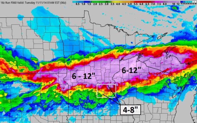
And the rumors are true: it's going to snow tomorrow. The air and ground will be cold enough for that snow to stick. Traffic may be a mess by afternoon. A plowable snowfall is likely; my concern is will it be 5 inches, or closer to a foot? A wave of low pressure passes south of Minnesota, throwing up a long-duration shield of light to moderate snow Monday morning into Tuesday morning.
Models consistently show an enhanced band of heavier snow with 6 to 12 inch snowfall totals possible over central Minnesota, even in the MSP metro. The first snow of the season is always memorable; this one should be a doozy.
Highs in the 20s, even a subzero low by next week? The maps do look bitter for the eastern USA, vaguely similar to last winter's pattern.
Don't assume the worst. Not yet.
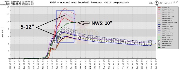 Model Ensemble Spread.
The heaviest snow band may set up just north of the Twin Cities, but
models are converging around 5-8" for the Twin Cities, possibly more for
the far northern suburbs depending on the final storm track. Graphic:
Iowa State.
Model Ensemble Spread.
The heaviest snow band may set up just north of the Twin Cities, but
models are converging around 5-8" for the Twin Cities, possibly more for
the far northern suburbs depending on the final storm track. Graphic:
Iowa State.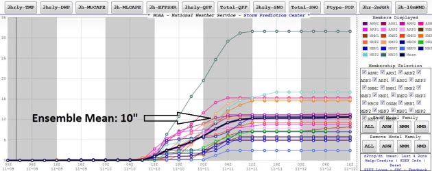
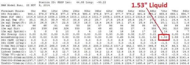
When A Forecast of 6-12" is Conservative. Check out the 00z NAM numbers from NOAA, a total of 1.53" liquid by midday Tuesday, all of it falling as snow. No mix, no changeover to ice or rain to keep snowfall amounts down. Could the storm take a more northerly track, pushing the heaviest snow bands into St. Cloud? Absolutely. But as of now there's a very real chance of some 8-14" amounts across the metro from Monday into midday Tuesday. Then it's going to get abnormally cold. Other than that, not much to talk about.
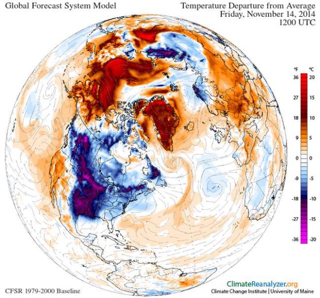
Son of Polar Vortex.
The pattern looking out into the third week of November does bring back
some scream-worthy memories of last winter. Not quite as harsh or
extreme as January of 2014, but temperatures will be as much as 20-30F
colder than average the latter half of this week and much of next week,
while abnormally warm air swirls around the Arctic Circle. Very odd.
Image above obtained using Climate Reanalyzer (http://cci-reanalyzer.org), Climate Change Institute, University of Maine, USA.
- October precipitation totals
were generally below-normal across most of Minnesota. Monthly rainfall
totals fell short of historical averages by one to two inches in most
locations. Areas of relative wetness were reported in some southeast
Minnesota counties where October rainfall totals topped historical
averages by an inch or more.
[see: October 2014 Precipitation Map | October 2014 Precipitation Departure Map | October 2014 Climate Summary Table] - Average monthly temperatures for October in Minnesota were near, to slightly above, historical averages. Cool temperatures early in the month were counterbalanced by a late-month warm spell..."
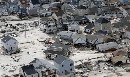
Why Sand Is Disappearing. Here's a snippet of an Op-Ed at The New York Times that got my attention: "...Today,
however, 75 to 90 percent of the world’s natural sand beaches are
disappearing, due partly to rising sea levels and increased storm
action, but also to massive erosion caused by the human development of
shores. Many low-lying barrier islands are already submerged. Yet the
extent of this global crisis is obscured because so-called beach
nourishment projects attempt to hold sand in place and repair the damage
by the time summer people return, creating the illusion of an eternal
shore..."
Sandy file photo: Mike Groll, AP.


TODAY: Fading sun, no travel problems. Winds: NW 10. High: 39
SUNDAY NIGHT: Cloudy with light snow spreading into western Minnesota. Low: 29
MONDAY: Winter Storm Watch. Snow gets heavier. PM traffic mess. High: 32
TUESDAY: Treacherous travel. Snow slowly tapers, band of 6-12" close to MSP? Wake-up: 26. High: 28
WEDNESDAY: Scrappy clouds. Roads still icy. Wake-up: 8. High: 25
THURSDAY: Average for mid-January. Nippy. Wake-up: 10. High: 27
FRIDAY: Partly sunny, feels like 10F. Wake-up: 8. High: 25
SATURDAY: Light snow develops. Few inches? Wake-up: 13. High: 28
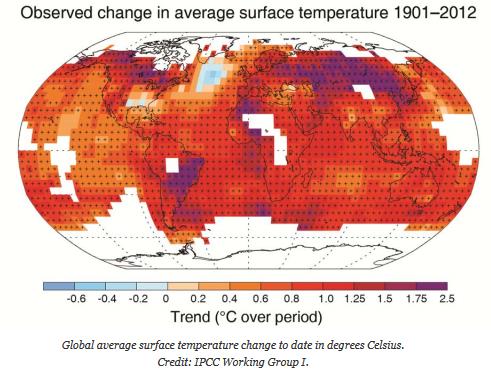
Climate Stories...

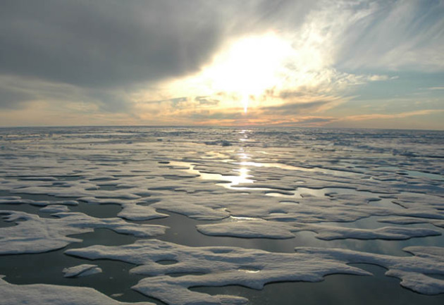
Climate Conflict Is Near, Admiral Warns. U-T San Diego has the story; here's an excerpt: "...But
land, fresh water and other essentials are at risk from the projected
effects of climate change, he said. The U.S. will see conflicts over
those assets unless we convert to clean energy, curb waste and prepare
for long-term challenges, he said. “Sea level is rising, population is
exploding, climates are changing, environments are being affected, and
the potential for a secure and prosperous 21st century is at risk if we
don’t start making some plans for opportunities that are not secured in
the next quarter’s return on investment and the next election,” Hering
said in an interview in advance of his presentation. “We need to make
investments for our grandchildren...” (Image: NOAA).
I Was Once A Climate Change Denier. Salon traces the chronology of one skeptic as he went from denying to ultimately accepting the science; here's a clip: "...As time went on, I was exposed to more and more evidence in support of climate change that I could no longer deny. I had no choice but to adapt my theory and finally admit to some sort of climate change. “OK, it may be happening, but how can you tell if it’s our fault? We lack a control Earth!” To back myself up, I clung to a variety of fringe arguments: “It’s the sun!” or “We can’t trust the measurements!” or “It has happened before! It’s normal!” and so on. (You can find a long list of common climate change myths debunked here and a shorter version here. Right now the list counts up to 176. New ones are added often.)..."

-Climate trends are clearly showing greater variability in some severe weather elements, including heavier rains, cluster outbreaks of tornadoes, more large hail, and seasonal changes in peak risk periods for hail, strong winds, and tornadoes. Peak season for heavy rainfall has shifted to August in our region.
-More research with reanalysis of upper air data and high resolution climate model outputs will be useful in further delineating the future risk of specific severe weather elements over finer scale geography.
-Climate trends are effecting recreation and tourism in terms of number of visitors and seasonal use and activity, e.g. northern MN more stable environment for winter recreation (skiing, snowmobiling, ice fishing); Mississippi River accessibility for educational programs has recently been restricted due to many high flow periods..."
No comments:
Post a Comment