25 F. average high on December 26.
26 F. high on December 26, 2013.
17 days with highs at or above 32F so far in December. December of 2013: 7 days of 32F+ highs.
6.8 F. December is running nearly 7F warmer than average as of December 26.
December 26, 1982: Snowstorm started across state and dumps 16 inches in the Twin Cities when it ended on the 28th.
Looks like December
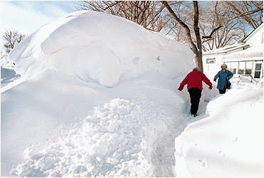
Welcome to the biggest snowfall of December! Not hard to do, considering up until today only 1.4 inches of snow had fallen at MSP all month. That may explain the scowls on the faces of snow lovers, statewide.
Last winter nearly 70 inches of snow fell, each approaching swirl of subzero air setting off a new burst of snow. And that snow didn't melt for the better part of 3 months!
Which brings up a question: do you prefer a gray El Nino winter of 30s, fog and scrappy clouds, or a Canadian winter: numbing sunshine, subzero air and frequent snowfalls?
Not that we have a choice in the matter, but I'm always intrigued by the tough choice between warmth and sunlight. Our coldest days tend to be sunny, but that's a tough combination for many people.
The leading edge of colder air sets off a plowable snow this morning; heaviest amounts south/east of the Twin Cities. No worries getting home tomorrow, in fact the pattern won't be ripe for another snowfall into the second week of January.
Like ocean waves breaking on the beach the cold surges southward in waves; a subzero low possible Wednesday morning, another surge of numbing air January 4-7. 20s return the second week of January with a shot at freezing. No extended polar pain in sight.
So far December is running nearly 2F warmer than November. We are very overdue for a correction.
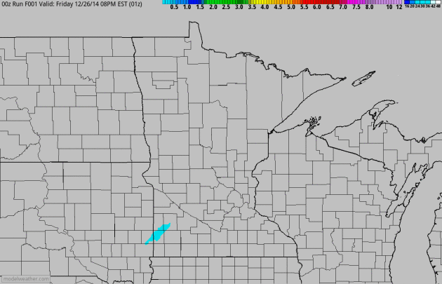
Snowy Stripe.
The 4 KM NAM/WRF model from NOAA did a good job placing last night's
snowy smear, the heaviest amounts over southwest Minnesota. Only 1.4" of
snow had fallen at MSP International Airport as of December 26. We were
due for a few inches. 60-hour snowfall accumulation loop: HAMweather.

Marginal Severe Risk Deep South; Heavy Rain/Snow Pacific Northwest.
A storm pushing across the far south may trigger a few strong to severe
T-storms from near New Orleans to Mobile, Huntsville and Atlanta over
the next 38 hours. Plowable snow pushes across Wisconsin into the U.P.
of Michigan, while the next Pacific storm spreads valley rains and
mountain snows into the Pacific Northwest.
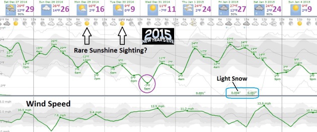
Cooling Trend.
Yes, it's going to get colder, but I still don't see anything to rival
last winter, at least not yet. We may wake up to negative numbers
Wednesday morning, New Year's Eve, for only the second time this winter
season. Temperatures recover to average late next week before another
temperature tumble early next week. Chart: WeatherSpark.
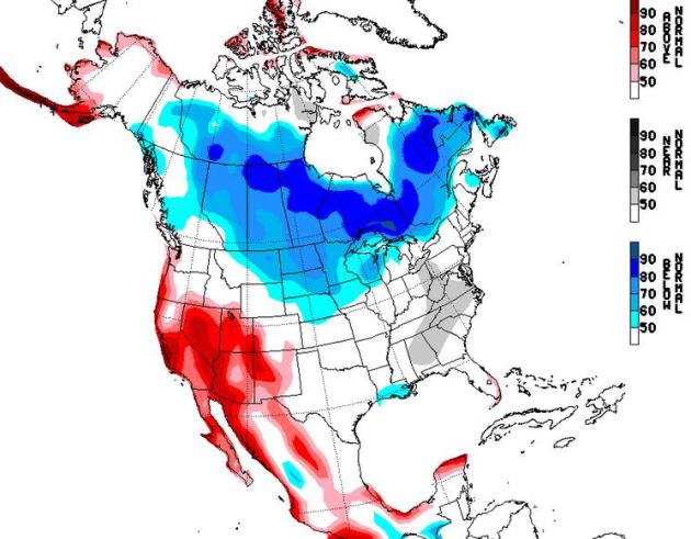
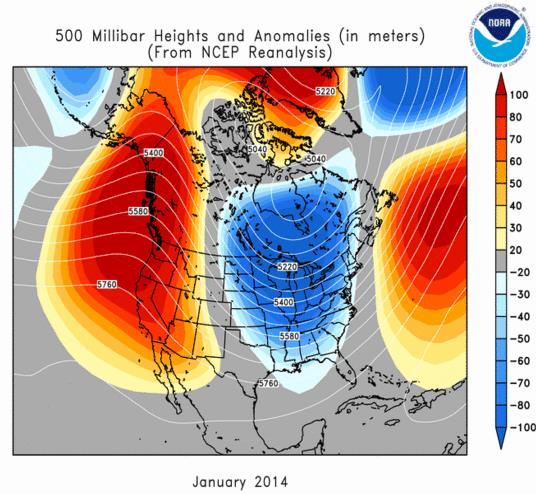
Cold Phase.
The map above shows NOAA NCEP's NAEFS long-range temperature anomalies
for January 3-9, showing a colder bias for the northern USA, warmer
weather for much of the west. The next 3-4 weeks are, historically, the
coldest weeks of the entire year.

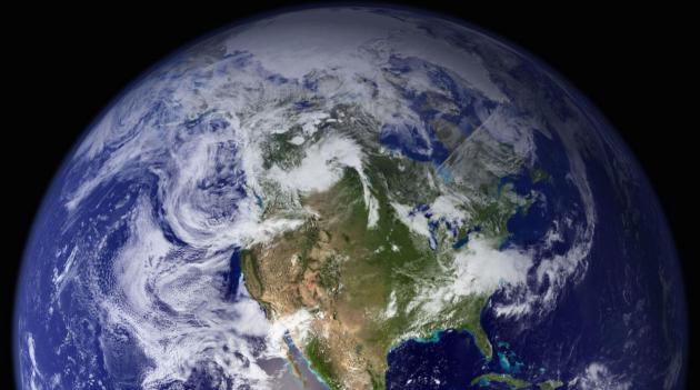
Image credit above: "Great Lakes and Central U.S. Viewed From the International Space Station." (Credit: NASA/Barry Wilmore).
#2 Record Wet June
June 2014 was the wettest June and the wettest month of the modern record for Minnesota. The state-averaged monthly rainfall total for June was 8.03 inches. Redwood Falls and Glencoe had 14.24 inches. The Twin Cities saw 11.36 inches, which fell just short of the June record of 11.67 inches from 1874. The impacts were flooded roads, farm fields, soggy basements and construction delays. One side benefit to the wet June was once the summer began to turn dry, plants were able to tap deep soil moisture from the June rains.
#1 The Cold Winter of 2013-14
There were many note-worthy parts of the winter of 2013-14. There were 53 nights of at or below zero temperatures in the Twin Cities. This tied for 5th place for the number of times the mercury dipped at r below zero in the Twin Cities for winters going back to 1872-73. International Falls had 92 at or below zero readings, tied 1977-78 as the most ever. Another measure was the extremely cold wind chill temperatures. The coldest wind chill temperature was -48 at the Twin Cities on January 6th and for the state it was -63 degrees at the Grand Marais Airport. The winter of 2013-14 will be one to compare to for many years to come.

TODAY. Snow tapers. 2-4" totals across much of the metro with slowly improving travel. High: 26
SATURDAY NIGHT: Patchy clouds, colder. Low: 16
SUNDAY: More clouds than sun, average temperatures. High: 25
MONDAY: Peeks of sun, feels like -5F. Wake-up: 6. High: 12
TUESDAY: Brisk sunshine, few extra layers. Wake-up: 1. High: 9
NEW YEAR'S EVE: Blue sky, stiff wind. Chill: -10. Wake-up: -2. High: 16
NEW YEAR'S DAY: Cloudy, flurries possible. Wake-up: 8. High: 24
FRIDAY: Still gray, seasonably cold. Wake-up: 12. High: 27
Climate Stories...
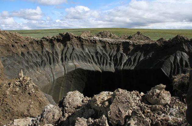
Photo credit: "July 2014, the first scientific expedition has just returned from the site with first probes." Pictures: Marya Zulinova, Yamal regional government's press service.
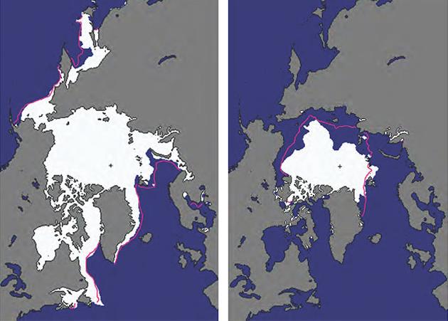
Graphic credit above: "Arctic sea ice extent in the winter maximum (left) and summer minimum (right) were both below average (pink line) in 2014." (Graphic: NOAA).
No comments:
Post a Comment