13 F. high in the Twin Cities Wednesday.
24 F. average high on December 31.
-1 F. high temperature on December 31, 2013
3" snow on the ground.
3 additional minutes of daylight at MSP since December 21.
December 31 in Minnesota Weather History. Source: Twin Cities National Weather Service:
2003:
On this date there is an inch of snow or less on the ground from Duluth
to the Iowa border. In the Twin Cities there isn't even a dirty
snowbank to be found.
1997:
Freezing rain along the North Shore causes numerous accidents. In Lake
County, vehicles could not get up hills and were blocking roads. Highway
61 was closed for several hours from Two Harbors to Silver Bay.
1864: Extremely bitter cold in Minnesota. Twin Cities had a high of 25 degrees below zero.
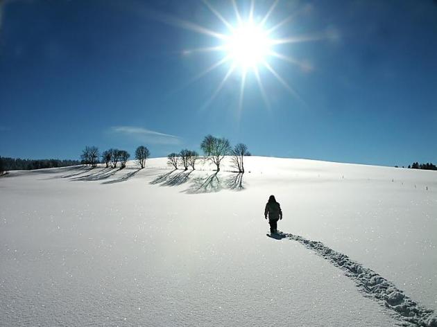
Happy New Year
In
2015 I'm not wishing for a bigger Doppler, a competitive edge or more
money. The world insists the key to happiness is MORE! When in reality
less is more.
Instead of accumulating more stuff I don't need I'm
hoping for a better work-life balance, new sights, a few good books,
ideas that challenge me. That, and making more time for my friends and
family. The most underrated blessing? Time.
But you can't package that in a 30-second commercial.
2014
was cooler than average with fewer tornadoes, less drought and epic
flooding in June. I'm betting on a warmer 2015, and odds favor more
jaw-dropping weather extremes. Based on multiple factors I still don't
believe that this winter will be as grueling as last, overall.
That said, next week may bring back chilling memories, possibly the coldest week of winter.
The
first half of the week brings single-digit highs and 4 nights/row of
subzero lows. Not all that unusual considering January 15 is the coldest
day of the year, on average.
20s will feel tolerable today; 30F
Saturday before a big temperature tumble. Another thaw arrives on
Pacific winds late next week.
I wish you and yours much happiness - and more time in the new year.
4 Days of Siberian Burn.
Although not as cold as January, 2014, the first half of next week
should get your attention with 3-4 days of single-digit highs and
nighttime lows below zero. Wind chill values Sunday, again Wednesday
morning may approach -35F in the metro area before temperatures recover
to near freezing by the end of next week.
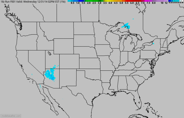
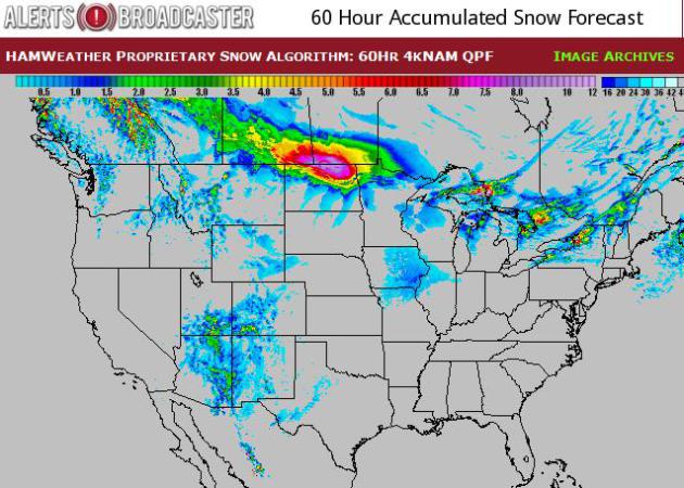
Tracking Accumulating Snow.
NOAA's 4 KM NAM shows a little lake effect snow, a cyclonic swirl of
snow pushing across the 4 corners region, and a Saturday smear of snow
pushing across North Dakota into Minnesota. Source: HAMweather.
Snowfall By Saturday Morning.
Significant snow and ice will avoid major U.S. population centers over
the next few days, the best chance of plowable snow over the U.P. of
Michigan and northern North Dakota into the Red River Valley by
Saturday.
Mid-South Soaker.
NAM guidance prints out some 2-4" rains near Little Rock and Memphis by
late Friday into early Saturday as an area of low pressure tracks
across the south; the atmosphere warm enough for rain.
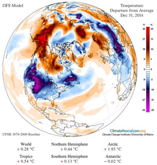
Baked Alaska. Andrew Revkin at The New York Time's
Dot Earth reports on unusually mild, snow-free weather across much of Alaska again this winter. Credit: Climate Reanalyzer.
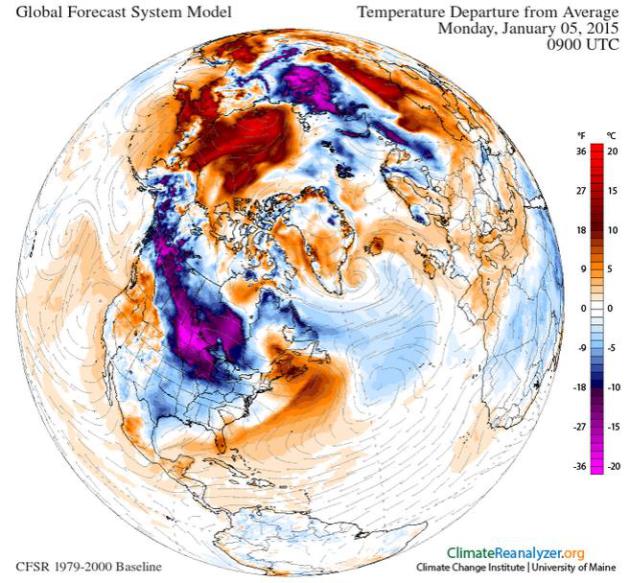
Canadian Pain.
NOAA's GFS model predicts temperatures as much as 20-30F colder than
average from the Dakotas into Minnesota and Wisconsin next Monday
morning. Meanwhile temperatures over the Arctic are 25-30F warmer than
normal for early January. Another upside-down weather map, but unlike
last winter I don't think the blocking pattern will persist.
Temperature anomalies obtained using Climate Reanalyzer (http://cci-reanalyzer.org), Climate Change Institute, University of Maine, USA
How To Beat The Winter Blues. PBS's
Next Avenue
has a timely article with good tips on steps you can take to better
weather the dark, depressing days of winter; here's an excerpt: "...
For
bright light therapy to work, you will need between 30 and 90 minutes
of exposure to it each day, according to the APA. Your doctor can give
you instructions. One method is to sit about two feet from the light
with your eyes open, but without looking directly at the lamp. Early
mornings, when the therapy can simulate sunrise, may be best. A
Minneapolis man said he takes his light therapy lamp out of the basement
each year in early- to mid-October. “I know it’s coming, that dark
period,” said Lee, 60, who asked to be identified only by his first name
to avoid the stigma associated with depression. He uses the lamp for
about a half-hour each morning, while reading the paper and eating
breakfast..."
How To Choose A Light Box.
The Mayo Clinic
has some good advice on how to choose a light box, one that simulates
sunshine and helps to relieve symptoms of SAD, Seasonal Affective
Disorder. Here's an excerpt: "...
A light box mimics outdoor light.
Researchers believe this type of light causes a chemical change in the
brain that lifts your mood and eases other symptoms of SAD. Most people
use light boxes for a minimum of 30 minutes each morning. You can buy a
light box over the counter, or your doctor may recommend a specific
light box. Most health insurance plans do not cover the cost..."
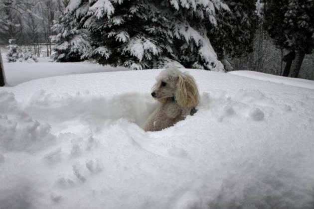
Protect Your Pet During Winter and Cold Weather. Here's a clip from an article at
The Humane Society with a few good reminders for all of us who love our pets and want to keep them safe yearround: "...
The
best prescription for winter's woes is to keep your dog or cat inside
with you and your family. The happiest dogs are those who are taken out
frequently for walks and exercise but kept inside the rest of the time.
Don't leave pets outdoors when the temperature drops. During walks,
short-haired dogs may feel more comfortable wearing a sweater. No matter
what the temperature is, windchill can threaten a pet's life. Pets are
sensitive to severe cold and are at risk for frostbite and hypothermia
during extreme cold snaps. Exposed skin on noses, ears and paw pads can
quickly freeze and suffer permanent damage..."
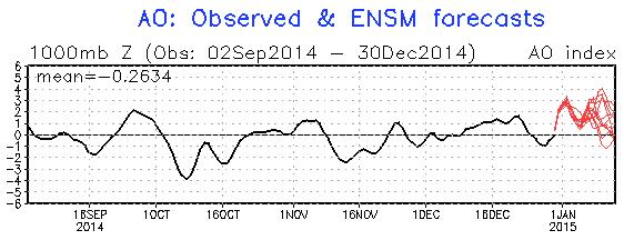
Positive Phase of Arctic Oscillation: Limit To How Cold It Can Get?
A strongly negative phase of AO and NAO correlates with a wavier jet
stream, higher amplitude flow capable of pulling down (and sustaining)
bitter winds from northern Canada for an extended period of time. The AO
was negative in mid-November, when we had our early snowstorm and
relatively early outbreak of numbing air. Then the AO tracked more
positive in mid-December, correlating with a streak of 40s and 3 days
above 50F. The forecast into mid-January calls for a positive AO, which
leads me to believe that any bitter air will be relatively brief, at
least compared to last winter. Source: NOAA.
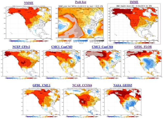
Climate Model Temperature Outlook: January - March, 2015.
We'll see plenty of cold frontal passages this winter; of that I am
fairly certain. This doesn't look like 2012, when spring came roaring
back in early March. But I still see little evidence that a persistent
blocking pattern, similar to last winter, will feed a steady supply of
Arctic air into the eastern two thirds of America. As I've been
explaning (ad nauseum) for weeks now the pattern appears to be more
variable, more frequent swings between Canadian air and Pacific air, as
temperatures alternative between (brief) subzero spells and 30s (above).
All of NOAA's climate models (except for GFDL FLOR) show average
temperatures or a mild bias for Minnesota during the first quarter of
2015.
Trouble At 30,000 Feet: The Violent Weather Pilots Hate And How They Grapple With It.
My pilot friends tell they will do just about anything to avoid flying
into thunderstorms, with the resulting wind shear, icing and hail risk.
Bloomberg takes a look at what keeps pilots up at night; here's an excerpt: "...
At higher altitudes aircraft engines are less efficient
due to the decreased density of the air, while lift created over the
wings is also lower. Higher altitudes can also increase the possibility
of ice formation either on the wings, which can limit the aircraft’s
ability to produce lift, or on sensors which track airspeed and
altitude. Higher altitude air is also harder to breathe, which is why
aircraft are pressurized. While thunderstorms do cause lightning,
serious accidents due to lightning strikes are extremely rare...."
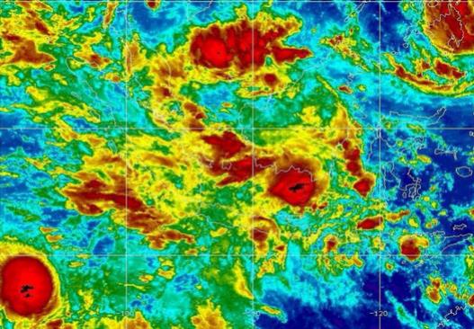
The Challening Weather Conditions When Air AsiaFlight 8501 Disappeared.
Was weather a factor? It's too early to know for sure, but
meteorologist Jason Samenow does a good job capturing the various
weather threats in the vicinity of the doomed flight at The Washington
Post's
Capital Weather Gang; here's a snippet: "...
However,
Vasquez believes it is plausible the aircraft encountered icing. Icing
refers to build-up of ice on the aircraft – which adds weight to the
aircraft and disrupts the flow of air over the wings. Vasquez concludes:
“… it appears that weather was a factor, or was a compounding factor.
The most likely hazard, if weather was a factor, appears to be icing.
This is only an assessment of best available meteorological information,
and is not a final determination on the cause of the incident...”
Image credit above: "
Infrared satellite imagery from around the time AirAsia flight 8501 disappeared portrays large thunderstorms in the vicinity." (NOAA)
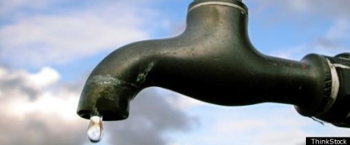
The Politics of Drinking Water. Here's an excerpt of an excellent story at
The Atlantic about something many of us take for granted, but probably shouldn't, access to clean, reliable drinking water: "...
Most Americans take cheap, safe drinking water for granted. Globally, one out of 10 people
can’t access clean water. Some 1,400 children die each day from
water-related diseases. Unless there’s a spill or equipment failure,
these numbers exclude U.S. residents. Across the 50 states, 155,000
public water systems treat, filter, and deliver 100 gallons per person
per day, all for the low cost of 20 cents per gallon. Contaminant-free
drinking water hasn’t always been part of the American experience..."
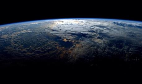
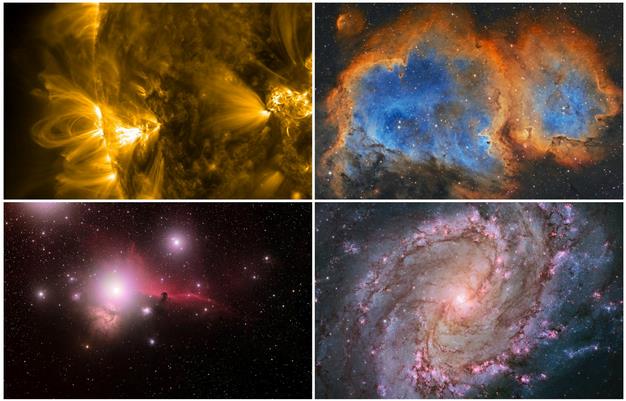
The Most Spectacular Space Photos of 2014. Newsfirst has a good summary with some remarkable photos; here's the intro: "
The
year 2014 was a stellar one for spaceflight, what with ESA’s Rosetta
mission putting a robotic lander on a distant comet and NASA
successfully testing its Orion spacecraft. But 2014 was also a great
year for space photography, as you can see from these remarkable images
picked for your viewing pleasure..."
Sony Hacking Attack, First A Nuisance, Quickly Grew Into a Firestorm. The New York Times takes a look behind the hacking. Here's the introduction: "It
was three days before Thanksgiving, the beginning of a quiet week for
Sony Pictures. But Michael Lynton, the studio’s chief executive, was
nonetheless driving his Volkswagen GTI toward Sony’s lot at 6 a.m. Final
planning for corporate meetings in Tokyo was on his agenda — at least
until his cellphone rang. The studio’s chief financial officer, David C.
Hendler, was calling to tell his boss that Sony’s computer system had
been compromised in a hacking of unknown proportions. To prevent further
damage, technicians were debating whether to take Sony Pictures
entirely offline..."
File photo: AP Photo/Ahn Young-joon.
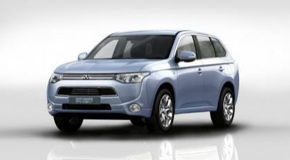
Mitsubishi Outlander Plug-In Hybrid Can Now Power Homes During an Outage. Here's a good idea, highlighted at
Gizmag: "
The
ability to plug electric vehicles into the mains raises the potential
for their connecting to and powering other devices as well. Mitsubishi
has announced that its Outlander PHEV can now do just that. Japanese users will be able to power their homes in the event of a power outage..."
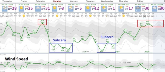
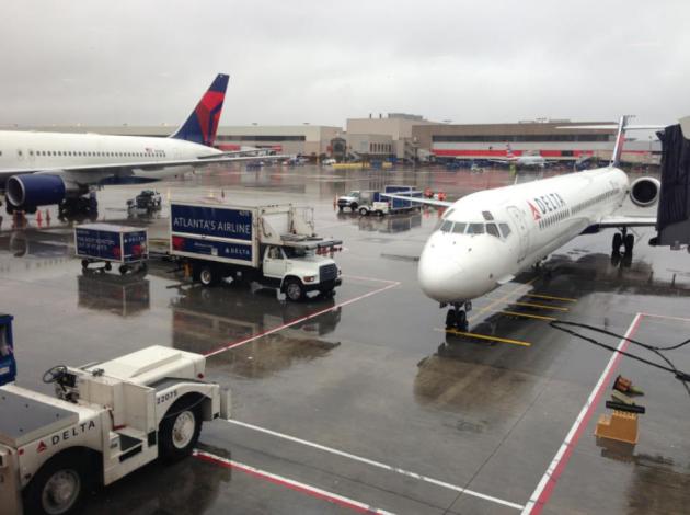
NEW YEAR'S DAY: Mostly cloudy, few flurries. Closer to average. West 10. High: 26
THURSDAY NIGHT: Clearing, turning colder again. Low: 4
FRIDAY: Sunny start, clouds increase later in the day. High: 21
SATURDAY: Milder with flurries, few inches snow far north. Wake-up: 14. High: near 30, falling sharply late.
SATURDAY NIGHT: Bitter winds, feels like 35 below. Low: -5
SUNDAY: Bitter sun. Feels like -35 at times. High: near 0
MONDAY: Some sun, less wind (and pain). Wake-up: -8. High: 4
TUESDAY: Flurries, then another cold shot. Wake-up: -3. High: 3
WEDNESDAY: Sunny, temperatures bottom out. Wake-up: -12. High: 6
* ECMWF guidance hints at 30s by the end of next week.
Climate Stories...
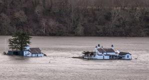
5 Places Transformed by Climate Change in 2014.
TriplePundit focuses in on specific examples of regions impacted by rising seas and a more volatile climate system; here's an excerpt: "...
With
record storms and flooding besieging the U.K.’s coastlines in past
years, the government’s Environment Department has estimated that as
many as 7,000 residences may be reclaimed by the sea
in the next century. At greatest risk, of course, are homes and
businesses that are vulnerable to storm surge, but last year’s
widespread flooding in cities has heightened awareness that Mother
Nature’s reach isn’t limited to coastlines. The tourist haven of
Cornwall, England is expected to lose the most homes to the sea in the next 50 years. More than 750 homes in England will face risk in the next 20 years..."
Photo credit above:
Adrian Kingsley-Hughes.
 Hottest Year Ever: 5 Places Where 2014 Temps. Really Cooked
.
Live Science takes a look back at some of the climate low-lights; here's an excerpt:
- Siberia:
Central Siberia defrosted in spring and early summer under temperatures
more than 9 F (5 C) above its 1981 to 2010 average. Ice on the Ob River
began to break up two weeks earlier than normal. The heat may have
unleashed methane gas trapped in previously frozen permafrost,
triggering underground explosions that formed spectacularly deep holes.
- California: The long-running drought in California
was made worse in 2014 by record heat. The first 10 months of 2014 were
the warmest in California's history since 1895, further burdening the
state's water demands....
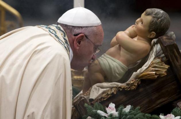
What Can A Popular Pope Do About Climate Change? Here's a clip from a story at
The Atlantic: "...
Francis has previously pointed
to the environment as being “one of the greatest challenges of our
time,” and he says that Catholics have a moral and scientific obligation
to protect it. But the move to publish an encyclical goes beyond offering a soundbite. “A
papal encyclical is rare. It is among the highest levels of a pope’s
authority,” Dan Misleh, director of the Catholic climate covenant, said
to The Guardian. The pope will distribute the
lengthy document to 5,000 Catholic bishops and 400,000 priests, who will
then share the message with their congregations in churches across the
world...."
Photo credit: AP Photo/Andrew Medichini.
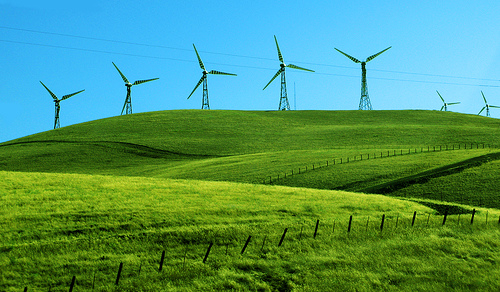
Will The New Year Bring More Wind, Less Warming? There
is no silver bullet, but plenty of silver buckshot, and wind power is
one (of many) solutions to generate clean, renewable energy. Here's an
excerpt from
Huffington Post: "...
California endured its third year of devastating drought. Washington state was ravaged by wildfire. In August, severe floods submerged Detroit and much of the East Coast. The World Meteorological Organization predicted 2014 would turn out to be the hottest on record.
These are exactly the type of extreme weather events scientists say
will increase and worsen due to unchecked global warming. What's more, a
steady stream of scientific reports in 2014 revealed that seas are already rising, ice caps are already melting and crop yields are already decreasing -- all due to climate change..."
2014: The Year Climate Change Undeniably Arrived. Here's an excerpt of a good summary of the year's climate headlines from
InsideClimate News: "...
All
year long, from the Antipodes to the Aleutians, the changing global
climate plagued the planet. If 2014 does not, in the final reckoning,
prove to be the hottest year ever recorded, it will come very close. As a
landmark scientific review
published by several U.S. government agencies declared in May: "Climate
change, once considered an issue for a distant future, has moved firmly
into the present." Of course, it did not happen all at once. The
Australian heat wave had lingered over from 2013. Every decade is now
warmer than the one before. Each new year is one of the warmest on
record. Young adults have never lived through a month when global
temperatures were cooler than the old normal..."
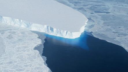
Fate of Earth's Ice Comes Further Into Focus. Here's an excerpt from a 2014 summary of the cryosphere from
Climate Central: "...
The
changes being wrought at both poles came into starker relief in 2014:
While Antarctic sea ice reached a record amount, Arctic sea ice
continued its inexorable decline, and at a much faster rate than the
Antarctic increase. At the same time, glaciers in Antarctica and
Greenland were found to be even more vulnerable to melt than previously
thought. One scientist said that the retreat and melt of some of
Antarctica’s fastest-moving glaciers had become “unstoppable...”
Photo credit above: "
Antarctica's Twaites Glacier, one of the six glaciers of the Amundsen Sea Embayment of the West Antarctic Ice Sheet." Credit: NASA.


No comments:
Post a Comment