30 F. high temperature in the Twin Cities Thursday.
24 F. average high on January 1.
1 F. high on January 1, 2013.
3" snow on the ground at MSP International Airport.
4.6 F. December was 4.6 F. warmer than average in the Twin Cities.
Cold Wave Next Week
"As the days lengthen the cold doth strengthen" the proverb goes.
Yes it doth.
We've
picked up 5 minutes of daylight since December 21 at the rate of a
minute a day. A higher sun angle won't begin to compensate for long,
Arctic nights until the 3rd week of January, when average temperatures
begin to inch upward again, for the first time since July.
Next
week may be the coldest of winter, but still a pale imitation of last
winter. January 6, 2014 our high was -12, after waking up to -23.
School-closing cold.
Next week's volley of polar pain arrives in
waves. Sunday and Tuesday may be the coldest days with stronger winds
creating a wind chill of -30F each day. In spite of bright sunshine
daytime highs may not rise above zero Sunday. An extra layer for running
or cycling but probably not cold enough to close school.
The
worst of the chill is over late next week, a chance of snow next weekend
as moisture surges north. Otherwise the main storm track takes a cold,
southerly detour the next week; a rude reminder that Canada is still
upwind.
"Stiff upper lip - this will only make us tougher!" a
friend reminded me. He was calling from Orlando, but no matter. This too
shall pass.
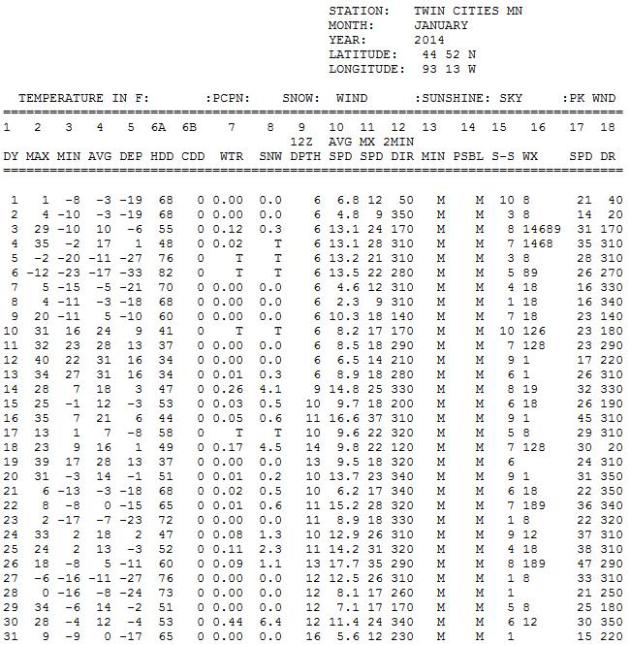
January Flashback.
Will this month rival January 2014? We'll see, but I doubt it. The
first month of 2014 brought 20 subzero nights and 3 subzero daytime
highs in the Twin Cities with 22.7" of snow. We'll see our share of
subzero nighttime lows this month, but I still doubt we'll see anything
as extreme as last winter. January 2014 Twin Cities climate details
above courtesy of
NOAA.
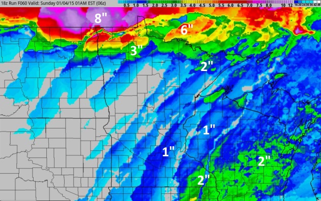
Saturday PM Coating?
The approach of much colder air will set off plowable snow amounts over
far northern Minnesota; closer to a coating to an inch from Brainerd
and Duluth into the Twin Cities. NOAA's 4 KM NAM shows a better chance
of 2"+ amounts from Rochester and La Crosse to Madison. Source:
HAMweather.
Southern Soaker.
NAM guidance continues to show a potential for flash flooding from near
Dallas to Little Rock, Shreveport and Memphis as moisture streams
northward from the Gulf of Mexico; a surge of rain pushing up the East
Coast Sunday and Monday ahead of the Arctic Express.
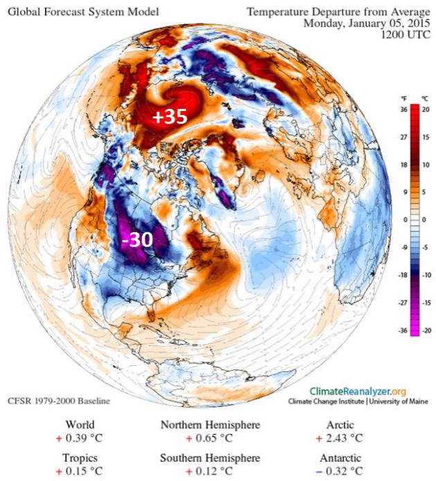
Monday Temperature Anomalies.
What is going on over the Arctic? Notice the cyclonic swirl of unusual
warmth, surface temperatures as much as 30-40F warmer than average.
Meanwhile a chunk of polar air pushes across Manitoba into the Dakotas
and Minnesota Sunday and Monday with temperatures running about 30F
colder than average for early January. Source:
Climate Reanalyer.
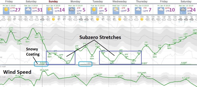
Yes, It's Cold Enough For Me.
After peaking near freezing midday Saturday temperatures go into a
freefall Saturday night and Sunday, in fact subzero highs are possible
Sunday, again Wednesday of next week as gusty winds make it feel like
-30 to -35F at times. Probably not cold enough to cancel school, but I
might think twice about recess outdoors. European guidance shows 20s
returning by the end of next week, which may be the coldest or one of
the 2 coldest weeks of winter. Source: Weatherspark.
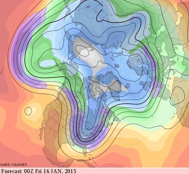
Mid-January Full Latitude Trough.
500 mb winds on Thursday evening, January 15 are predicted to carve out
a deep trough of low pressure capable of spinning up a major storm for
the East Coast; a dry, seasonably cold flow for Minnesota and the Upper
Midwest, while unusual warmth lingers across much of the western USA.
Source: GrADS:COLA/IGES.
Trouble At 30,000 Feet: The Violent Weather Pilots Hate And How They Grapple With It.
My pilot friends tell they will do just about anything to avoid flying
into thunderstorms, with the resulting wind shear, icing and hail risk.
Bloomberg takes a look at what keeps pilots up at night; here's an excerpt: "...
At higher altitudes aircraft engines are less efficient
due to the decreased density of the air, while lift created over the
wings is also lower. Higher altitudes can also increase the possibility
of ice formation either on the wings, which can limit the aircraft’s
ability to produce lift, or on sensors which track airspeed and
altitude. Higher altitude air is also harder to breathe, which is why
aircraft are pressurized. While thunderstorms do cause lightning,
serious accidents due to lightning strikes are extremely rare...."
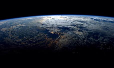
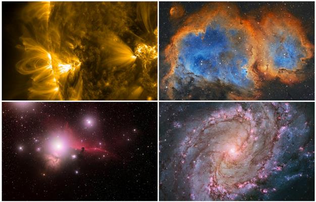
The Most Spectacular Space Photos of 2014. Newsfirst has a good summary with some remarkable photos; here's the intro: "
The
year 2014 was a stellar one for spaceflight, what with ESA’s Rosetta
mission putting a robotic lander on a distant comet and NASA
successfully testing its Orion spacecraft. But 2014 was also a great
year for space photography, as you can see from these remarkable images
picked for your viewing pleasure..."
Sony Hacking Attack, First A Nuisance, Quickly Grew Into a Firestorm. The New York Times takes a look behind the hacking. Here's the introduction: "It
was three days before Thanksgiving, the beginning of a quiet week for
Sony Pictures. But Michael Lynton, the studio’s chief executive, was
nonetheless driving his Volkswagen GTI toward Sony’s lot at 6 a.m. Final
planning for corporate meetings in Tokyo was on his agenda — at least
until his cellphone rang. The studio’s chief financial officer, David C.
Hendler, was calling to tell his boss that Sony’s computer system had
been compromised in a hacking of unknown proportions. To prevent further
damage, technicians were debating whether to take Sony Pictures
entirely offline..."
File photo: AP Photo/Ahn Young-joon.
TODAY: Clouds increase, average temps. for early January. Winds: SW 8. High: 25
FRIDAY NIGHT: More clouds, not as cold. Low: 17
SATURDAY:
Mild start, then windy, much colder later in the day with flurries (few
inches of snow far northern MN). High: 30, then falling sharply late in
the day.
SATURDAY NIGHT: Clearing with bitter winds. Low: -6
SUNDAY: Bitter sun, feels like -35F. High: -3
MONDAY: Clouds increase, cancel recess. Wake-up: -16. High: 6
TUESDAY: Snow tapers, bitter winds. WC: -35. Wake-up: -5. High; near 0
WEDNESDAY: Arctic sunshine. Bug-free. Wake-up: -11. High: 3
THURSDAY: Few flurries, not quite as harsh. Wake-up: -7. High: 12
Climate Stories...
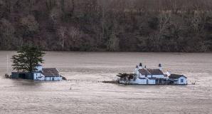
5 Places Transformed by Climate Change in 2014.
TriplePundit focuses in on specific examples of regions impacted by rising seas and a more volatile climate system; here's an excerpt: "...
With
record storms and flooding besieging the U.K.’s coastlines in past
years, the government’s Environment Department has estimated that as
many as 7,000 residences may be reclaimed by the sea
in the next century. At greatest risk, of course, are homes and
businesses that are vulnerable to storm surge, but last year’s
widespread flooding in cities has heightened awareness that Mother
Nature’s reach isn’t limited to coastlines. The tourist haven of
Cornwall, England is expected to lose the most homes to the sea in the next 50 years. More than 750 homes in England will face risk in the next 20 years..."
Photo credit above:
Adrian Kingsley-Hughes.
 Hottest Year Ever: 5 Places Where 2014 Temps. Really Cooked
.
Live Science takes a look back at some of the climate low-lights; here's an excerpt:
- Siberia:
Central Siberia defrosted in spring and early summer under temperatures
more than 9 F (5 C) above its 1981 to 2010 average. Ice on the Ob River
began to break up two weeks earlier than normal. The heat may have
unleashed methane gas trapped in previously frozen permafrost,
triggering underground explosions that formed spectacularly deep holes.
- California: The long-running drought in California
was made worse in 2014 by record heat. The first 10 months of 2014 were
the warmest in California's history since 1895, further burdening the
state's water demands....
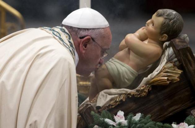
What Can A Popular Pope Do About Climate Change? Here's a clip from a story at
The Atlantic: "...
Francis has previously pointed
to the environment as being “one of the greatest challenges of our
time,” and he says that Catholics have a moral and scientific obligation
to protect it. But the move to publish an encyclical goes beyond offering a soundbite. “A
papal encyclical is rare. It is among the highest levels of a pope’s
authority,” Dan Misleh, director of the Catholic climate covenant, said
to The Guardian. The pope will distribute the
lengthy document to 5,000 Catholic bishops and 400,000 priests, who will
then share the message with their congregations in churches across the
world...."
Photo credit: AP Photo/Andrew Medichini.

No comments:
Post a Comment