28 F. high in the Twin Cities Wednesday.
29 F. average high on December 10.
13 F. high on December 10, 2013.
December 10, 1983:
Nine cars fell through the ice at the same time on Buffalo Lake in
central Minnesota. There was only 5 to 6 inches of ice on the lake.
December 10, 1979: The temperature dropped in Roseville from 48 degrees at 2 pm to zero by dawn.
December 10, 1916: Montevideo had its fifty-second consecutive day with no precipitation.
Pausing Winter
Since
1899 there have been a total of 32 Christmases in the Twin Cities with
no snow or a trace of snow, qualifying as a "brown Christmas". The last
time this happened was 2011. Unless the pattern shifts dramatically and
unexpectedly, I'm expecting a snow-optional Christmas this year.
Blame
(or thank) El Nino, a mild stain of water in the Pacific. Yesterday the
Japan Meteorological Agency called it the first official El Nino in 5
years.
Who cares?
Historically, El Nino has a domino effect
worldwide, impacting not only ocean currents but how jet stream steering
winds set up. Big storms tend to slam into California, track across the
far southern USA before turning up the East Coast - a pattern we're
already seeing manifested on the weather maps. We'll still see cold
fronts, but during an El Nino winter winds aloft blow from the Pacific
with greater frequency, meaning milder and (usually) drier for
Minnesota.
Exhibit A: we should hit 40F tomorrow; 50s possible
over the weekend - 20 to 25F warmer than average. Moist, Pacific air
passing over cold ground will spark clouds and thick fog at times, even a
little rain Sunday.
I don't see any accumulating snow between now and Christmas Eve.
* One year ago today the Twin Cities woke up to -8F with an afternoon high of 5F. Source:
NOAA.
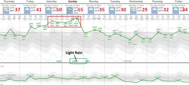
Shot at 50F.
40s are likely, and if everything goes just right we may hit 50F
Saturday, low to mid 50s possible Sunday before temperatures cool back
down closer to average early next week. No big storms of any flavor are
brewing, but ECMWF guidance hints at a little rain or drizzle during the
PM hours Sunday.
Wet West Coast Smack.
It may be one of the biggest storms to push into California since the
last El Nino 5 years ago. Models hint at 3" of rain in the Bay Area
today, 1-2" near Los Angeles and San Diego tomorrow - snow tapering off
over New England. 60-hour accumulated precipitation: NOAA and
HAMweather.
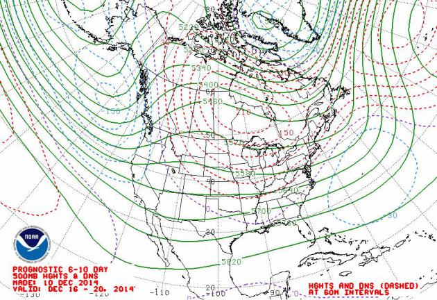
Mild Bias Next 2 Weeks.
Although temperatures peak this weekend a mild, Pacific wind aloft
blows much of the next 2 weeks, keeping temperatures above average for
the next 10-12 days. There are some signs of a colder front right around
Christmas Eve or Christmas Day; not bitter, but closer to average.
Accumulating snow? I don't see any looking out the next 2 weeks. If we
do see a white Christmas it'll be by the skin of our teeth. Map: NOAA.
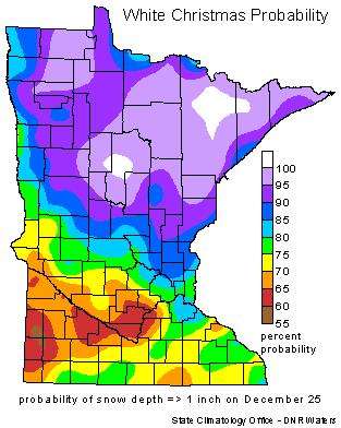
Historical Chances of a White Christmas?
On average 72 out of 100 December 25ths have an inch or more of snow on
the ground at MSP International, for those of you who live at the Twin
Cities airport this is helpful information. Some days I feel like I live
there, come to think of it. Just waiting for MSP to go condo. Here's a
clip from the
Minnesota DNR: "...
In
115 years of snow depth measurements in Twin Cities, a white Christmas
happens about 72% of the time. From 1899 to 2013 there have been 32
years with either a "zero" or a "trace." The last time the Twin Cities
has seen a brown Christmas was 2011. The deepest snow cover on December
25th was in 1983 with a hefty 20 inches. It was also a very cold
Christmas in 1983, with the high temperature of one (1) degree F. It was
not the coldest Christmas Day in the Twin Cities. That dubious award
goes to 1996 with a "high" temperature of 9 below zero F. The warmest
Christmas Day in the Twin Cities was 51 degrees in 1922. There was not a
white Christmas that year. In fact, the Minneapolis Weather Bureau log
book for that day states that the day felt "spring like..."
First El Nino In Five Years Declared By Japan's Weather Bureau.
This call isn't universally shared by other weather services, like NOAA
or Environment Canada, or even Australia's Bureau of Meteorology, but
it's an acknowledgment that the Pacific is warming up. Here's an excerpt
from
The Guardian: "
Japan’s
weather bureau said on Wednesday that an El Niño weather pattern, which
can trigger drought in some parts of the world while causing flooding
in others, had emerged during the summer for the first time in five
years and was likely to continue into winter. That marks the first
declaration by a major meteorological bureau of the much-feared El Niño
phenomenon, which had been widely expected to emerge this year..."
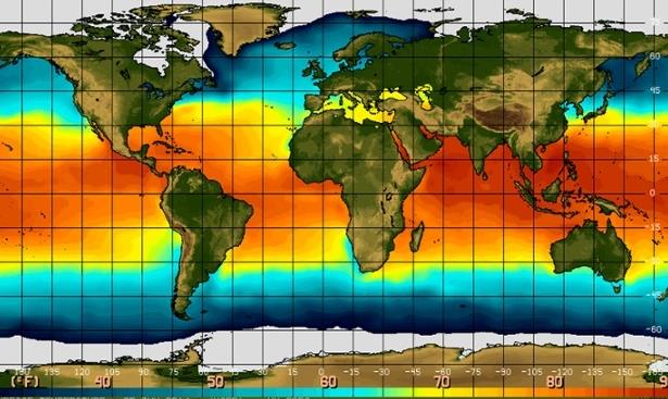
Map credit above: "
Global
temperatures sea surface levels in June. Weather agencies have been
predicting an El Niño all year but Japan’s is the first to declare it." Photograph: NOAA.
*
El Nino Outlook from JMA, Japan Meteorological Agency, is
here. More information on the emerging El Nino from
Climate Crocks.
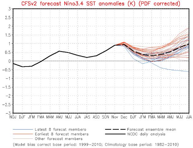
El Nino Lingers into Mid 2015. NOAA says a 65% chance of El Nino this winter, lasting into the middle of 2015.
Details here. This is one of many reasons why I suspect the core of the upcoming winter season won't be as harsh as last winter.
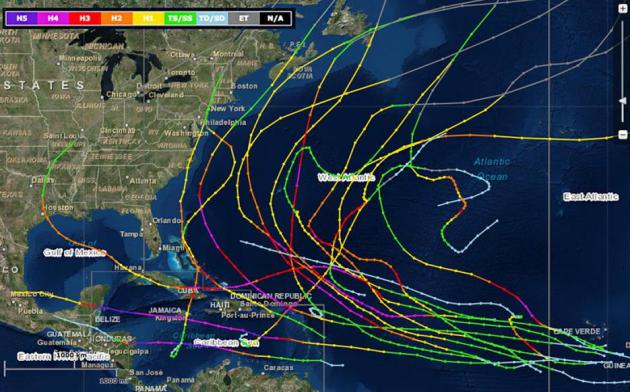
Why Hasn't A Major Hurricane Hit The U.S. In 9 Years?
Andrea Thompson has a good summary focused on what meteorologists know
and don't know about the recent Atlantic hurricane drought. Meanwhile
the Pacific experienced 7 Category 5 typhoons this year. All or nothing.
Chalk it up to luck? Here's an excerpt from
Climate Central: "...
The
drought of major hurricane hits is unmatched according to records
stretching back to the 1950s. And its reason is a mystery. Experts chalk
it up to chance, rather than any identifiable climate pattern or the
effect of global warming. After all, major hurricanes have raked Mexico
and many Caribbean countries in that nine-year interval. Even Sandy was a
major hurricane when it hit Cuba. “Other people have been bearing the
brunt,” Gerry Bell, the lead seasonal hurricane forecaster for the National Oceanic and Atmospheric Administration (NOAA), said. “We’ve just been fortunate...”
Map credit above: "
The
tracks of all hurricanes that reached major hurricane status (Category 3
or higher) in the Atlantic Ocean basin from the 2006 through 2013
hurricane seasons." Credit: NOAA.
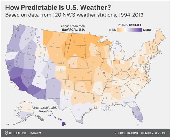
Which City Has The Most Unpredictable Weather?
Oh to be a meteorologist in Rapid City, South Dakota. The greatest
weather extremes in general come near the center of large continents,
well away from the moderating influence of warmer ocean water. Here's an
excerpt from a long but excellent story at Nate Silver's
FiveThirtyEight: "...
But
Rapid City isn’t alone; other cities in the Great Plains and Upper
Midwest dominate the most-unpredictable list. After Rapid City, those
with the most unpredictable weather are Great Falls, Montana; Houghton,
Michigan; Sioux Falls, South Dakota; Fargo, North Dakota; Duluth,
Minnesota; Bismarck, North Dakota; Aberdeen, South Dakota; Grand Island,
Nebraska; and Glasgow, Montana. For the most part, these cities are
landlocked. The presence of lakes or oceans can contribute to weather
problems — for instance, the huge amounts of lake-effect snow
in Houghton, in Michigan’s Upper Peninsula (about twice as much as in
notoriously snowy Buffalo, New York). But water usually does more to
regulate temperatures and severe weather..."
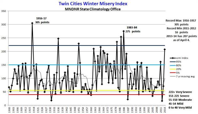
The Story Behind The Winter Misery Index. Meteorologist Andrew Freedman had a good story about the origin of the WMI at
Mashable back in February that's worth a read; here's an excerpt: "...
The
index attempts to put the “badness” or “goodness” of winter into
historical context, Bousted said. The index is based on daily
temperature and precipitation data, including snowfall and snow depth.
It uses thresholds of temperature and snowfall to assign a score to each
day, which gets tallied up throughout a season, with a running tally
and a final score at the end of the year to gauge a winter’s severity.
The scores correspond to a category, with a one-through-five system —
with five being the worst — similar to those used for other severe
weather phenomena..." (Graphic credit above:
Minnesota DNR).
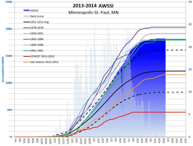
The Accumulated Winter Season Severity Index.
Yes, WMI roles off the tongue, but the original index is the AWSSI.
Here's an excerpt of a good explanation of how this running winter index
is calculated and updated from the
Midwest Regional Climate Center: "...
Daily
scores are calculated based on scores assigned to temperature,
snowfall, and snow depth thresholds. The daily scores are accumulated
through the winter season, allowing a running total of winter severity
in the midst of a season as well as a final, cumulative value
characterizing the full season. Accumulations of the temperature and
snow components of the index are computed separately and then added
together for the total index. This allows comparison of the relative
contribution of each to the total score..."
* More information on Barbara Boustead's new winter rating scale from the AMS, the
American Meteorological Society.
Scientists Find Early Warning Signs of Changing Ocean Circulation.
Rapid melting of polar regions is flushing more fresh water into the
North Atlantic, which may (over time) impact a global conveyor belt of
moving water around the planet. Here's a clip from
UPI: "
The
Atlantic Meridional Overturning Circulation, or AMOC for short, is the
large-scale flow of water -- driven by temperature and salinity
gradients -- specific to the Atlantic Ocean. Researchers say they've
located signs that it and other portions of Earth's oceanic conveyor
belt are slowing. The global conveyor belt doesn't just move water, it
moves heat too -- delivering it (in the case of the AMOC) from the
tropics and the Southern Hemisphere to the North Atlantic. It is a vital
component of climate as we know it. Should it continue to slow and
become disrupted, it could spell drastic and abrupt climate change..." (Graphic credit:
NASA).
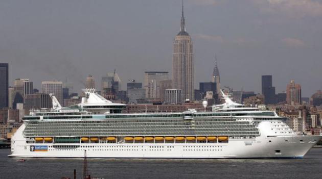
Cruise Ships Dump 1 Billion Gallons of Sewage Into The Ocean Every Year. So please don't play in the ocean anytime soon.
Quartz has the horrific details; here's an excerpt: "
Some
20 million people board cruise ships every year. And while they might
return to land with fond memories of umbrella drinks and shuffleboard,
they leave a lot at sea. About a billion gallons (3.8 billion liters) of sewage (pdf), in fact.
That’s according to Friends of the Earth, a non-governmental
environmental group, which used US Environmental Protection Agency data
to calculate arrive at that gross figure..."
Photo credit above: "These city-sized behemoths generate a lot of waste." (Reuters/Keith Bedford).
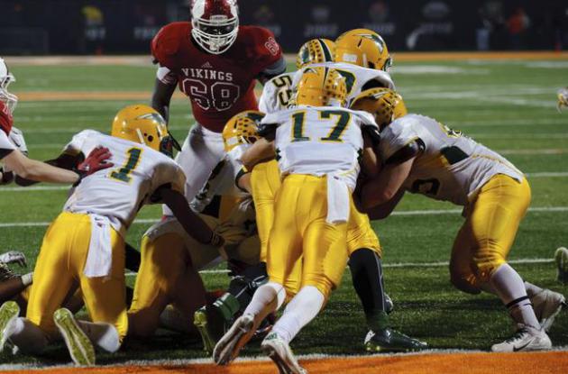
Half of Americans Don't Want Their Sons Playing Football, Poll Shows. Here's the intro to a story at Bloomberg Politics: "Television ratings are up and merchandise sales are booming, but longer-term trends don’t look as rosy for football. According to a new Bloomberg Politics poll,
50 percent of Americans say they wouldn't want their son to play the
sport and only 17 percent believe it’ll grow in popularity in the next
20 years..."
File photo credit: AP Photo/Bradley Leeb.
How Your Heatbeat Will Make Passwords Obsolete. But what happens when my high blood pressure acts up? Here's a clip from
CNN: "
Thought
your fingerprint was secure? Think again. The unique pattern on the tip
of your fingers can easily be copied and used to access your most
personal information. As PIN numbers and passwords prove redundant in
protecting data, tech companies are looking to convert bodily features
into secure identity authenticators. Bionym, the Toronto-based biometrics technology company, have introduced The Nymi
-- a wristband that measures heartbeats to authenticate identity. Its
embedded sensor reads the electrical pulses produced by your heartbeat,
which is unique to each of us..."
TODAY: Mostly cloudy. PM thaw. Winds: South 5-10. High: 34
THURSDAY NIGHT: More clouds, fog possible. Low: 29
FRIDAY: Clouds & fog, turning milder. High: 41
SATURDAY: Foggy & gray. Touch of March. Wake-up: 33. High: 49
SUNDAY: Mild and murky. A little PM rain. Wake-up: 45. High: 51
MONDAY: Unsettled, turning colder. Light mix southern MN? Wake-up: 31. High: 35
TUESDAY: Mostly cloudy, closer to average. Wake-up: 24. High: 31
WEDNESDAY: Peeks of sun. Still quiet. Wake-up: 20. High: near 30
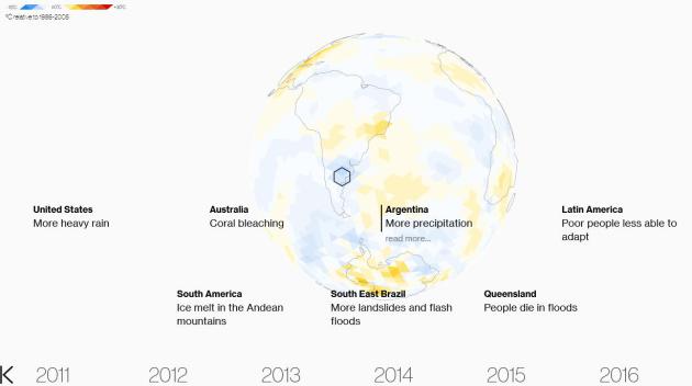
Climate Stories....
Global Weirding Is Here. Here is a
terrific visualization of future emission scenarios and impacts on weather volatility.
 Editorial: Human Nature vs. Global Warming. Humans Are Winning, And That's Bad News
. Here's an excerpt of an Op-Ed at
The St. Louis Post-Dispatch: "
You’d
almost think the world has no intention of fixing this problem. In
which assumption you would be at least partially correct. If the world
could fix its greenhouse gas problems painlessly, it would have been
done long ago. But this is a problem that — if you address it seriously —
would require significant lifestyle changes
on the part of every human being living in even modestly developed
nations. No politician who wants to keep his or her job is going to do
that by preaching sacrifice..."
The Secret Deal To Save The Planet. Here's an excerpt of the historic agreement between China and the USA to lower greenhouse gas emissions at
RollingStone: "...
The
agreement comes at a time when awareness of the risks of climate change
has never been higher, thanks to the sobering accretion of extreme
weather events around the world. But the prospects for significant
action to reduce carbon pollution have never been lower. Which is why
virtually everyone in the climate world was stunned when the agreement
was announced on November 12th..." (File photo above: NASA).
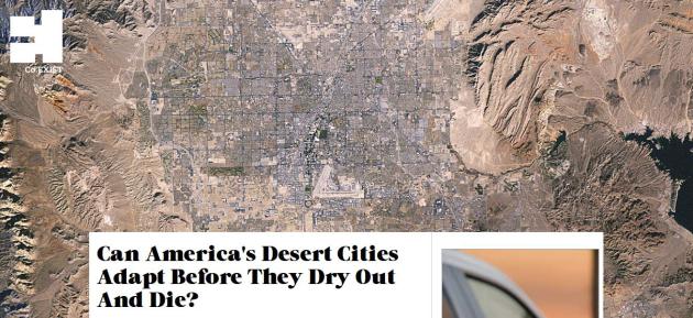
Can America's Desert Cities Adapt Before They Dry Out And Die?
Water will become a stark manifestation of the climate volatility we're
already witnessing. You may not care about a few degrees and more heat
waves in the summer. Odds are you will care if the water supply runs
out. Here's an excerpt from
Fast Company: "...
With some scientists saying California could be in the midst of a 35-year megadrought,
and other parts of the southwest feeling the same strain, desert cities
in America will have to cope with more water scarcity, projected
climate-change-induced temperature increases of up to 10 degrees Fahrenheit and a continuing growth in population. Some estimates put the population of the Greater Phoenix area at around 28 million by the year 2050,
from its current population of about 4 million. That's a lot of extra
water. There are several ways to combat these problems and change the
ways desert cities exist..."
Water Terrorism: How Militant Groups Are Taking Advantage of Climate Change Impacts. As a general rule dry areas are getting drier, wet areas are becoming wetter over time. Here's an excerpt of a story at
Breaking Energy that caught my eye: "...
One
of the more salient concerns to emerge from the impact of a warming
planet is water scarcity, as scientists have inextricably correlated
these two concepts for decades. However, what we are seeing now are
terrorist groups taking advantage of areas with water shortages and
manipulating water resources as a coercive tactic. The militant group,
the Islamic State (ISIS or ISL) has put the issue in focus as a
significant security concern and humanitarian crisis. For many
geographically-disadvantaged nations in the world that are already
dealing with water concerns, the impact of climate change isn’t going to
be felt 20, 30, or 40 years from now. The impacts are being felt today
and will only worsen as time goes on..."
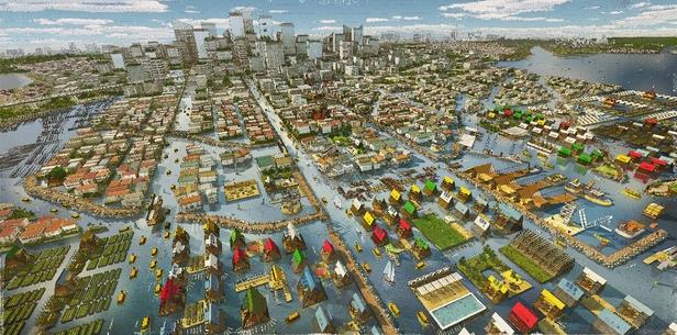
How MoMA, How "Tactical Urbanism" Can Preserve The Future of Cities.
CityLab takes a look at how mega-cities may be able to factor rising sea level into future growth plans; here's an excerpt: "...
The
teams working in Lagos (NLÉ, Lagos and Amsterdam, and
Zoohaus/Inteligencias Colectivas, Madrid) and Hong Kong (MAP Office,
Hong Kong, and Network Architecture Lab, Columbia University, New York),
however, smartly address the looming issue of sea-level rise affecting
the world’s most vulnerable populations. The basis for some of their
floating, Venice-like schemes is appropriately vernacular, drawing on
decades of local knowledge about how to live with water..."
Graphic credit above: "
A rendering of Future Lagos, with city design that works with rising sea levels." Courtesy NLÉ and Zoohaus/Inteligencias Colectivas.
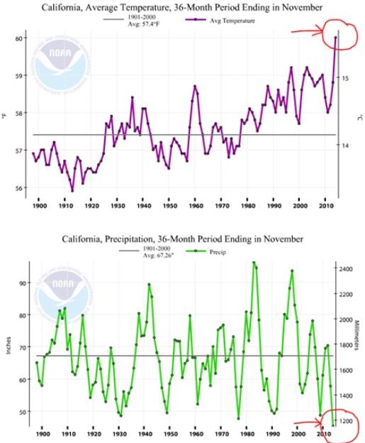
Once-In-1200-Year-California Drought Bears Signature of Climate Change. Here's an excerpt from Joe Romm at ThinkProgress: "...It
is the combination of reduced precipitation and record temperatures
that make this a 1-in-1200-year drought. This was the same point made to
me by California-based climatologist Dr. Peter Gleick, one of the
world’s leading water experts. He pointed out that in fact “the last 36
months are the hottest AND driest 36 months in the instrumental record.
for California,” and sent me these NOAA charts..."
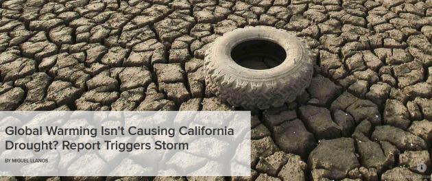
Global Warming Isn't Causing California Drought? Report Triggers Storm.
Many climate scientists are pointing out that the recent NOAA report
focused on California was a precipitation study, not a drought study.
Here's an excerpt of a summary of some new research at
NBC News: "
Natural
conditions, not human-caused emissions of greenhouse gases, are the
driving force behind California's three-year dry spell, scientists on a
federal task force concluded Monday. But the report came under fire from
some experts who said it downplayed other factors that have humanity's
fingerprints on them. The evidence suggests a naturally induced "warm
patch" of water in the western Pacific helped to create a high-pressure
ridge that blocked precipitation from entering California, the experts
said at a news conference to release the report..."
Photo credit above: Noah Berger, Reuters.
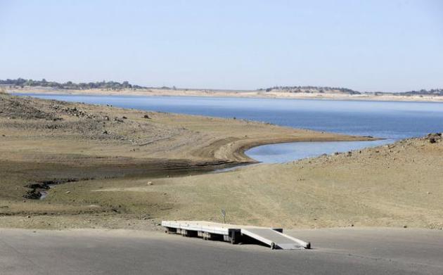
Asking What "Caused" California's Drought Misses The Point.
Meteorologist Eric Holthaus addresses the impact of extreme heat and
soil moisture depletion on the historic California drought in
Slate; here's a clip that caught my eye: "...
One
of Gleick’s main criticisms of the NOAA study was that “they completely
ignored the temperature question, which is by far the clearest signal.”
He continued, “There’s just no dispute that temperatures globally are
going up. There’s no dispute that temperatures regionally in California
are going up. There’s no dispute that the last three years have been the
hottest in the instrumental record [in California]. And, there’s no
dispute that hotter temperatures increase water demand in California.
The exact same drought with normal temperatures is not as bad...”
File Photo credit above: "In
this Oct. 6, 2014 file photo, a dock sits high and dry at the end of a
boat ramp yards away from the edge of Folsom Lake near Folsom, Calif.
Don’t blame man-made global warming for the devastating California
drought, a new federal report says. A report issued Monday by the
National Oceanic and Atmospheric Administration said natural variations _
mostly a La Nina weather oscillation _ were the primary drivers behind
the drought that has now stretched to three years." (AP Photo/Rich Pedroncelli, File)
Dramatically Increasing Chance of Extremely Hot Summers Since The 2004 European Heatwave. The abstract and paper are available at
nature.com.


No comments:
Post a Comment