28 F. high in the Twin Cities Friday.
24 F. average high on January 2.
4 F. high on January 2, 2014.
3" snow on the ground at MSP International Airport.
January 2, 1981: Arctic air visits Minnesota. Embarass, Wannaska, and Tower all hit 38 below zero.
January 2, 1977: 14.2 inches of snow falls in Mankato.
Cold Wave Coming
If
we were living in Honolulu, Miami or L.A. a cold wave would be breaking
news. Minnesota, in January? I'd be amazed if it didn't get cold! And
if we ever get to the point where we see no snow or cold fronts the
planet will have much bigger problems.
Some perspective is in
order. Temperatures usually bottom out in mid-January, about 3-4 weeks
after the Winter Solstice. Yes, there's a lag. January of 2014 brought
20 subzero nights and 3 subzero days as a misplaced chunk of polar air
stalled near Hudson Bay, sending spokes of pain south of the border on a
regular basis.
And yes, I got a dollar every time I mentioned "polar vortex" on TV.
Not
this year. The pattern is more variable, alternating between polar and
Pacific, and after the coldest outbreak of winter next week a Pacific
flow pulls 20s and 30s back into town by mid-January.
Not to
minimize next week's discomfort. Lows dip below zero every night next
week; subzero "highs" Sunday & Wednesday as the wind chill dips to
-40F, down into the danger zone.
Snow tracks across far northern Minnesota today but a plowable snow is possible here Monday night.
OK, January in Minnesota is an acquired taste. You may have time to cash in those frequent flier miles.
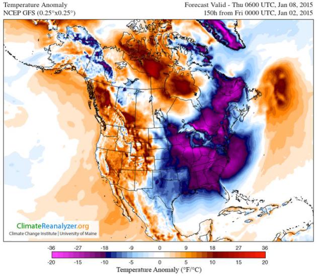
* Temperature anomaly prediction (NOAA GFS model) valid next Thursday morning, courtesy of
Climate Reanalyzer.
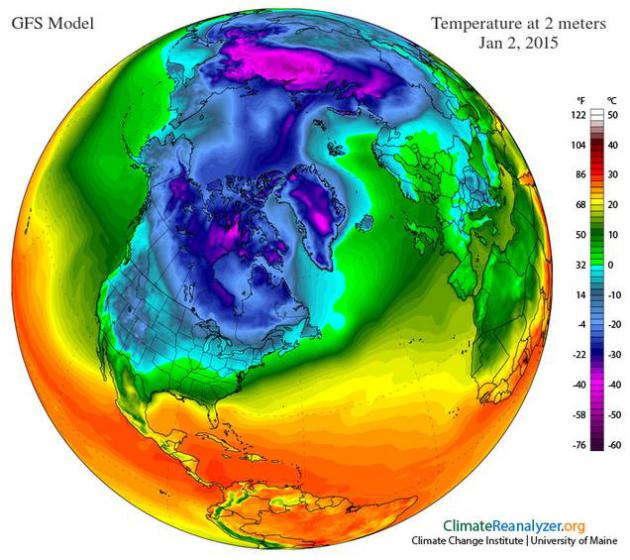
Siberian Breeze.
An airmass that will rival January of 2014 arrives tonight;
temperatures probably holding below zero Sunday, Monday and Wednesday of
next week as what may be the coldest airmass of winter pushes south in
two separate waves. I see no evidence of a blocking pattern capable of
sustaining subzero beyond 5 or 6 nights, if that's any consolation. Not
really. 2 meter Friday temperatures: Climate Reanalyzer.
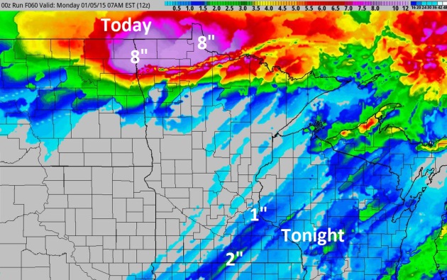
Snowy Burst Tonight.
Today's storm puts down as much as 8" of snow near Hallock and Roseau,
where the sledding will be extra-good. The snow drought lingers over
much of central and northern Minnesota though, with little more than a
coating to an inch from the Twin Cities to Rochester and Eau Claire
tonight as bitter air rushes south. 60-hour accumulated snow: NOAA 4 KM
NAM and HAMweather.
72-96 Hours Below Zero?
It won't be consecutive hours of negative numbers, but expect subzero
temperatures most of Sunday and Monday, very slight recovery Tuesday
before the second wave arrives late Tuesday night and Wednesday. The
third push of bitter air nudges the mercury below zero again Friday
before the mercury returns to normal next Sunday. Note to self: whatever
doesn't kill you makes you stronger. Uh huh.
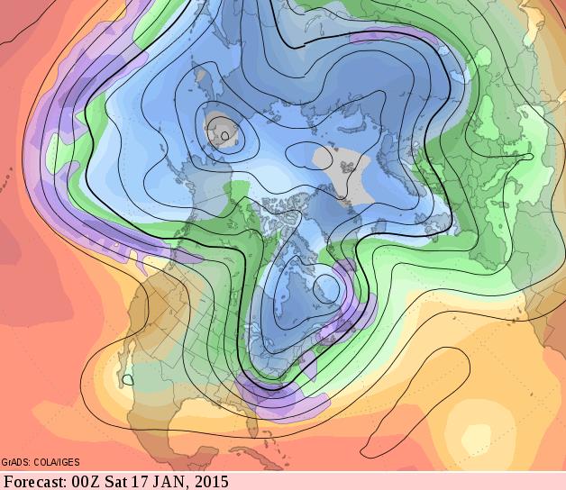
Some Recovery Mid-January.
GFS guidance shows the core of the coldest air pushing east of Hudson
Bay and the Great Lakes by mid-January. Although winds aloft are still
howling from the northwest it looks like a modified Pacific flow for
much of the western USA, Minnesota on the fringe of numbing air. I still
think there's a good chance next week will be the coldest of the entire
winter. Source: GrADS:COLA/IGES.
December Numbers. Thanks to Greg Spoden, Minnesota State Climatologist at the DNR for passing on a
detailed recap of weather across the great state of Minnesota last month; here's an excerpt:
- December
precipitation totals were close to historical averages across large
portions of Minnesota. In many locales, a significant fraction of the
monthly precipitation came in the form of mid-December rain. However,
northwest and north central counties missed out on the bulk of these
rainfall events and monthly precipitation totals in those areas were
about one-half inch short of historical averages.
- Snow
depths are less than four inches in most Minnesota communities. Little
or no snow cover is on the ground across large sections the state. Snow
depths are well below median for the northern two-thirds of Minnesota.
- The
U. S. Drought Monitor indicates that Abnormally Dry conditions exist
over large sections of Minnesota, the result of a dry late summer and
autumn.
- Average monthly temperatures for December in
Minnesota were above historical averages, ranging from five to seven
degrees above normal. Warm and very humid conditions in mid-December led
to a number record-setting high overnight temperatures and high dew
point temperature readings...."
*
2014: 6th Coolest Year on Record for Iowa. Details from
The Des Moines Register.
Alerts Broadcaster Briefing. Issued Friday, January 2, 2015.
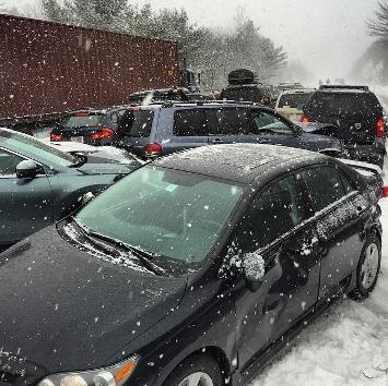
Massive Accident on I-93 near North Ashland, New Hampshire This Morning. WCVB-TV in Boston is reporting as many as 50-100 vehicles involved as a sudden snow squall created glaze ice conditions.
Here is what we're tracking:
*
Significant icing event from north Texas into southwest and central
Oklahoma. As much as 1/4 to 1/2" of ice may accumulate on streets, trees
and power lines in the Oklahoma City area over the next 24 hours; some
power outages are likely.
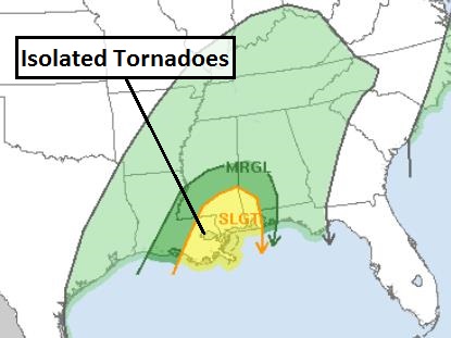
* Slight severe thunderstorm risk for New Orleans and Mobile Saturday - a few isolated tornadoes can't be ruled out.
*
Any wet snow quickly changes to rain for major east coast population
centers Saturday and Sunday; 1-2" rains may spark urban flooding.
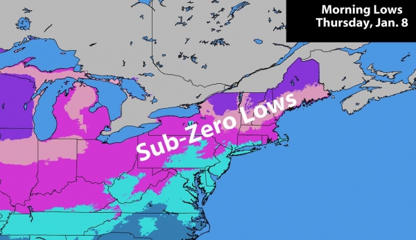
*
Coldest air of the winter pushing south next week in two separate
waves. Subzero temperatures likely Monday into Thursday from the Midwest
to New England, even the Mid Atlantic region, as wind chills dip into
the extreme danger zone from Minneapolis and Chicago to Cleveland,
Pittsburgh, Boston, New York, even Washington D.C.
Ice Storm Potential.
A surge of moisture coming out of the Gulf of Mexico will drop
significant rain from Midland and Wichita Falls, Texas to Lawton, Altus
and Oklahoma City, Oklahoma. The problem: surface (ground) temperatures
are below freezing, so that rain will freeze on contact, creating a
dangerous glaze ice scenario which may extend into the metropolitan
Oklahoma City area today and tonight. Power outages are likely and
traffic by land and air will be negatively impacted. Map: Oklahoma City
National Weather Service office.
Saturday Severe Risk.
NOAA SPC has issued a slight risk of severe storms from New Orleans and
Gulfport to Mobile, Alabama for hail and a few isolated tornadoes.
January is entering prime-time for severe weather along the Gulf Coast.
Map: NOAA SPC.
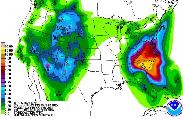
Urban Flood Advisories.
The same storm that's spawning ice for north Texas and Oklahoma will
spread heavy rain into the Ohio Valley and much of the eastern USA. That
rain may begin as a little slush from New York to Hartford and Boston,
with a rapid changeover to rain Saturday into Sunday. 1-2" rain falling
on frozen ground may spark urban flooding from Pittsburgh and Louisville
to New York and Baltimore; a better chance of flash flooding over the
Lower Mississippi Valley from Memphis and Nashville to Huntsville and
New Orleans. 5-Day precipitation outlook: NOAA WPC.
Coldest Air of Winter Next Week?
Some of the early model guidance I'm seeing, especially from the ECMWF
(European) model suggests a couple of waves of bitter air pouring south,
starting Saturday night and Sunday from the Twin Cities to Milwaukee
and Chicago, reaching the Great Lakes, Ohio Valley and New England
Tuesday, with another shot coming in Thursday. I expect subzero lows
with wind chills reaching -20F to -30 from Boston to New York by the end
of next week. Although not as extreme as last winter, the cold will be
the big story next week.
Summary: We're tracking
severe icing pushing into Oklahoma City, the risk of a few stray
tornadoes near New Orleans and Mobile Saturday afternoon and heavy
weekend rains causing minor to moderate street flooding up and down the
east coast this weekend. Next week the big story is subzero chill
pushing south of the border - what will probably be the coldest week of
winter is shaping up. We'll keep you posted.
Paul Douglas - Senior Meteorologist - Alerts Broadcaster

2014: Warmest Year On Record for Phoenix and Central Arizona.
Click here for more details from Phoenix National Weather Service.
Trouble At 30,000 Feet: The Violent Weather Pilots Hate And How They Grapple With It.
My pilot friends tell they will do just about anything to avoid flying
into thunderstorms, with the resulting wind shear, icing and hail risk.
Bloomberg takes a look at what keeps pilots up at night; here's an excerpt: "...
At higher altitudes aircraft engines are less efficient
due to the decreased density of the air, while lift created over the
wings is also lower. Higher altitudes can also increase the possibility
of ice formation either on the wings, which can limit the aircraft’s
ability to produce lift, or on sensors which track airspeed and
altitude. Higher altitude air is also harder to breathe, which is why
aircraft are pressurized. While thunderstorms do cause lightning,
serious accidents due to lightning strikes are extremely rare...."
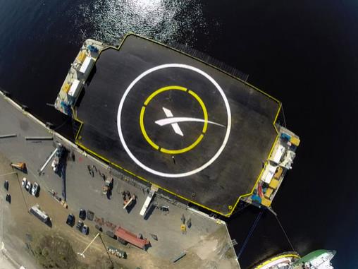
2015 Will Be The Year of SpaceX's Reusable Rocket.
Quartz has the details of a fairly radical, cost-saving idea; here's an excerpt: "...
SpaceX’s Jan. 6 launch will send a remotely piloted space capsule to the ISS with food, experiments, and two tiny, Earth-observing satellites
called cubesats. But the arguably bigger news is that the company, led
by CEO and chief rocket designer Elon Musk, will attempt to fly the
rocket that carries it into orbit back to earth and land it on a
floating platform akin to an oil rig...."
Image credit above: SpaceX.
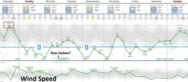
TODAY: Last "mild" day. Coating of snow late. Winds: S, then NW 15-30 late. High: 30
SATURDAY NIGHT: Gusty and sharply colder. Low: -6
SUNDAY: Peeks of sun, olar pain. Feels like -30. Winds: NW 20+ High: -2
MONDAY: Bitter. Few inches snow at night from the next clipper. Wake-up: -14. High: 3
TUESDAY: Snow tapers. Icy travel. Wind chill: -30. Wake-up: 0. High: 10 (falling rapidly again).
WEDNESDAY: Sunny. Coldest day of the winter? Wind chill -45 early. Wake-up: -16. High: -4
THURSDAY: Clouds increase, not as harsh. Wake-up: -9. High: 18
FRIDAY: Blue sky. More fresh air. Wake-up: -2. High: 8
Climate Stories...
Baked Alaska: Climate Change in the Arctic. The
rate of warming for far northern latitudes far exceeds anything we're
seeing across the USA, with uncertain implications. Climate scientists
point out that we are now in uncharted waters. Here's an excerpt from
The Energy Collective: "...
This
latest report shows that Arctic air temperatures continue to rise at
more than twice the rate of global temperatures, a phenomenon scientists
call “Arctic amplification,” causing a range of impacts. Among them are
increasing air and sea surface temperatures, declining reflectivity (albedo) of Greenland’s ice sheet, diminishing spring snow cover on land and summer ice on the ocean, and the declining health and numbers of some polar bear numbers, including those in the Hudson Bay region.
The Arctic is the climatic canary in a coal mine, impacting not only
Arctic populations and ecosystems, but the global climate system as well..."
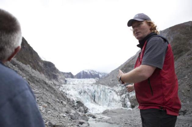
New Zealand Glaciers Ebb and Tour Guides Play Catch Up. Here's a clip from a story at
The New York Times: "...
Two
of the glaciers there, Fox and Franz Josef, have advanced several times
since they were first measured more than a century ago, scientific
figures show. But both have retreated farther in the last five years
than they advanced in the preceding 25 years, and scientists predict the
retreat will continue over the long term. “There is no doubt that the
retreat has been caused by climate change,” Brian Anderson, a
glaciologist at Victoria University in the capital of Wellington who
studies both glaciers, said in an email..."
Photo credit above: "
Malcolm
Richards of Fox Guide Glaciers leads tourists on a hike up Fox Glacier
on the West Coast of New Zealand, Oct. 4, 2014. Tourists once came to
this remote town to hike across glaciers, but now helicopters are the
only way to reach many of them - one of the many ways in which climate
change is effecting the global tourism industry." (Guy Frederick/The New York Times).
5 Places Transformed by Climate Change in 2014.
TriplePundit focuses in on specific examples of regions impacted by rising seas and a more volatile climate system; here's an excerpt: "...
With
record storms and flooding besieging the U.K.’s coastlines in past
years, the government’s Environment Department has estimated that as
many as 7,000 residences may be reclaimed by the sea
in the next century. At greatest risk, of course, are homes and
businesses that are vulnerable to storm surge, but last year’s
widespread flooding in cities has heightened awareness that Mother
Nature’s reach isn’t limited to coastlines. The tourist haven of
Cornwall, England is expected to lose the most homes to the sea in the next 50 years. More than 750 homes in England will face risk in the next 20 years..."
Photo credit above:
Adrian Kingsley-Hughes.


No comments:
Post a Comment