15 F. high in the Twin Cities Wednesday.
23 F. average high on January 14.
34 F. high on January 14, 2014.
January 14, 1972:
Cold air invades the region with a minimum temperature of -33 degrees F
at Alexandria, -32 at Eau Claire, and -29 at the Minneapolis-St Paul
International Airport.
 More Trend Than Fluke
Odds
favor another wet spring, with rapid drying in late summer and autumn.
In fact this may be a trend. Dr. Mark Seeley told me 4 of the last 5
springs in Minnesota have been historically wet.
Now
comes new research from Dr. Keith Harding, a climate scientist at the
University of Minnesota. Rapid warming is impacting the GPLLJ, the Great
Plains Low Level Jet. Implications? Summer rainfall is already becoming
less frequent and more intense. In fact the timing and intensity of
summer rain is already changing, according to Harding. People may not
see a dramatic change in total summer rain, but how much and how often
it rains has a much bigger impact on people's livelihoods. "With less
frequent and more intense rain, on top of higher temperatures, farmers
and backyard gardeners would need much more water to maintain enough
soil moisture" he added. Details below.
Freezing will feel
ridiculously good later today, Friday and Saturday. We cool off again
next week; a couple of glancing blows of arctic air by late month, but
probably not as cold as last week.
A few wimpy cosmetic snowfalls are possible, enough to give the gritty snow in your yard a quick facelift.
Woo hoo!
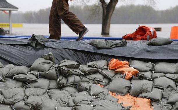
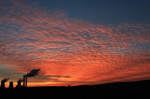
Photo above: AP.
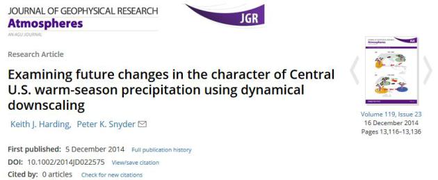
Examining Future Changes In The Character of Central U.S. Warm Season Precipitation Using Dynamical Downscaling.
Here is a link
to Dr. Harding's research referenced above, outlining observed changes
in the timing and intensity of summer precipitation events, possibly
linked to changes in the low-level jet: "...
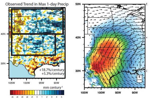
Significant
intensification of the heaviest rainfall events occurs in the models,
with the greatest changes in the early warm season (April). Increases in
total April–July rainfall and the enhancement of extreme rainfall
events in the RCP8.5 2090s are related to a stronger Great Plains
Low-Level Jet (GPLLJ) during those months. Conversely, late warm-season
drying over the North Central U.S. is present in nearly all future
simulations, with increased drought in August–September associated with a
slight weakening of the GPLLJ. Simulated trends generally increase with
stronger greenhouse gas forcing..."
Q&A With Keith Harding at the University of Minnesota.
I asked Dr. Harding for more information on his research, what it means
for Minnesotans. I've certainly noticed this in recent years, and
conveyed my sense that the patterns were changing. Here's an excerpt of
my e-mail conversation with answers to my questions:
1) "
Summer
rainfall over Minnesota is becoming less frequent and more intense
(with more days between rain events), with an acceleration of this trend
expected with climate change. Similarly, heavy rain events are becoming
more frequent and intense, and even greater increases are likely as the
planet warms further."
2) "
Our research demonstrates
that the timing and intensity of summer rainfall over the Midwest is
already changing, and climate change is expected to drive even larger
changes. We show that while there is large uncertainty about how total
summer rainfall may change, the models consistently show that the
frequency and intensity of rain will be clearly affected by climate
change."
3) "
We didn't look into how Arctic Amplification
may affect rainfall patterns over the Midwest, but I think the jury is
still out on the link between AA and extreme events. Conceptually I
think it makes a lot of sense, but in reality it's hard to conclusively
determine whether the rapidly warming Arctic is causing a lot of these
extremes. Unfortunately, it's probably going to take a lot more research
(and many more decades of observations) to conclusively answer that
question."
"
I think one final thing I would add is that
people may not see any change whatsoever in the total summer rainfall
they measure in their own rain gauges or in official records, but how
much and how often it rains has a much bigger impact on people's
livelihoods. With less frequent and more intense rain (on top of higher
temperatures), farmers and backyard gardeners would need much more water
to maintain enough soil moisture. Heavier downpours typically require
more robust infrastructure to reduce flooding. In this study, I think we
conclusively demonstrate that these important aspects of summer
rainfall have rather consistent and clear signals, all of which get
stronger with greater warming..."
Confirmation: 2014 Warmest Year On Record, Worldwide. Here's an excerpt from Climate Nexus: "
This
Friday, NOAA and NASA will officially declare 2014 as the hottest year
in 134 years of record keeping, with an expected annual global
temperature 0.68°C above the 20th century average according to NOAA’s dataset. In 2014, seven out of 12 months tied
or topped previous monthly global temperature records. Oceans in
particular experienced record warmth, with seven consecutive months—May
through November—setting new records for surface ocean heat. Most
importantly, 2014 sets the new global temperature record in the absence
of an El Niño, a phenomenon which raises global temperature. Many of the
previous hottest years on record have occurred during El Niño years, including 2010 and 2005, which now share the record for second hottest year..."
* More on the joint NOAA/NASA announcement
here.
A Belated January Thaw.
Then again, the thaw may have come in mid-December, come to think of
it. 30s spill over into midday Saturday before cooling off early next
week; temperatures next week still a couple degrees milder than average
for this time of year. This will come as a shock but no major storms are
brewing looking out 7-10 days. Source: WeatherSpark.
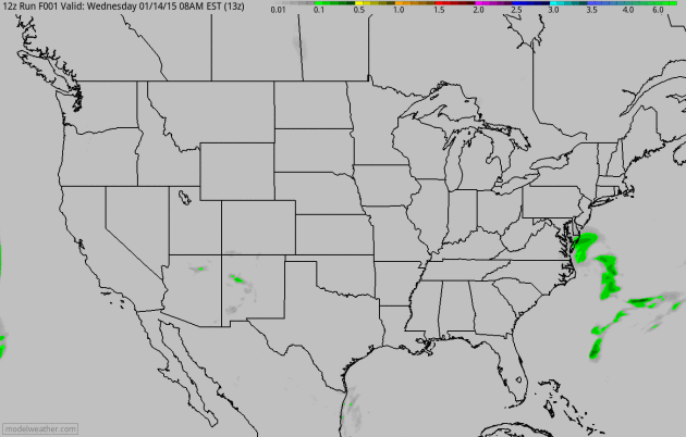
Another West Coast Storm.
NAM guidance shows moderate to heavy rain spreading into to the Pacific
Northwest and northern California by late week; a cold rain for the
Gulf Coast as a clipper pushes light snow across far northern Minnesota
and the U.P. of Michigan. Animation: NOAA and HAMweather.
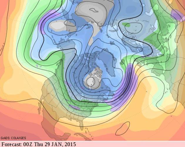
Cold Gyre For Late January - Early February.
It remains to be seen whether temperatures sink lower than last week,
but there's little question we'll see a rerun of typical mid-winter
weather within a few weeks. I may be a naive optimist but I still
suspect the coldest weather (duration of subzero temperatures and wind
chill) is behind us. Source: GrADS:COLA/IGES.
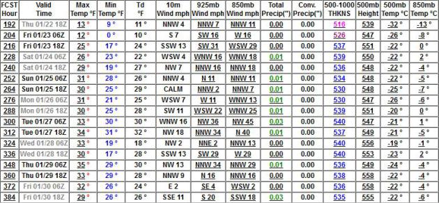
GFS: Coldest Air Passes North Next 2 Weeks.
My confidence level is low because the models keep jumping around, but
there's at least a chance the core of the coldest air will pass north of
Minnesota the last week of January.
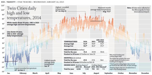
2014 Weather: Yes, Cold Was Brutal, But How About That Autumn? In case you missed it in print or online, Bill McAuliffe at
The Star Tribune has a terrific look back at last year's manic weather; here's the intro: "
Minnesota
was a cool place to be in 2014. Very cool. While the rest of the globe
panted through what’s likely to be the warmest year on record, “polar
vortex” became a household term in Minnesota. Said vortex also shoved
the state into its coldest year since 1996. In the Twin Cities, the
urban heat island became a tiki-torch ice bar, with the coldest winter
in 34 years. (Remember those 53 days with below-zero readings?) Duluth,
already well-known for its bone-chilling temps, suffered through the
coldest winter in 141 years..."
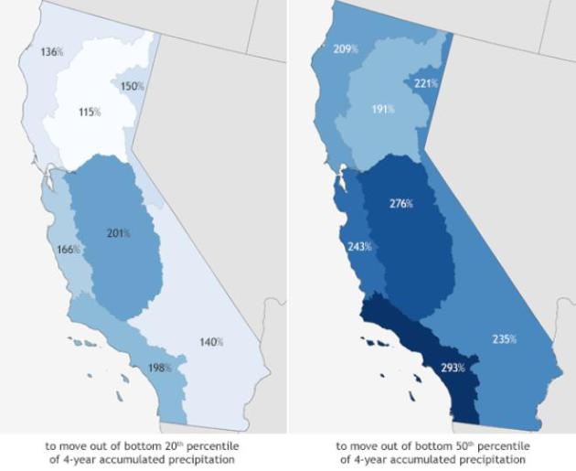
California Still Needs A Ridiculous Amount Of Rain To End Its Drought. Vox has the details; here's an excerpt that caught my eye: "...
The
big problem here is that California is really, really dried out — and
it takes a lot more than a few storms to fill the shortfall. Back in
December, an analysis from NASA led by Jay Famiglietti estimated that
the state needed nearly 11 trillion gallons of water
to fill its rain deficit — a process that could take years. Another way
to look at this, as NOAA did, is that the state needs rainfall far, far
above the historical average between now and September to even begin to
make up the shortfall..."
Map credits above: "
Percent
of normal precipitation required from mid-December through the end of
the water year in September in order to reduce rainfall deficits." (
Climate.gov/NOAA Climate Prediction Center.)
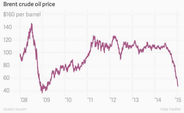
A Return To Oil At $32 A Barrel Is No Longer Unthinkable. Quartz has the story; here's the intro: "
After
plunging below $50 per barrel, oil has just a few hours later pushed on
without resistance and seems headed for the $30s, a price not seen
since the doldrums of 2008. The
immediate trigger has been a swatting down of a market rumor that OPEC
would surely go into emergency session this month or next to cut
production..."
The End Of OPEC As We Have Known It Is Here.
Fortune has the analysis; here's an excerpt: "...
Some
of the effects are welcome, others not. For Russia, whose budget
depends heavily on oil revenues, the decline in oil prices is a
financial disaster. The ruble’s foreign exchange value has already been
cut in half. Terrorists in the Middle East arm themselves with revenue
from oil. In the U.S., the development of shale fields has often been
funded with credits that are held by banks and high-yield bond funds.
Many of these credits could default..."
The American Way Over The Nordic Model. Are We Crazy? Here's an excerpt from an Op-Ed at
The Los Angeles Times: "...
All
the Nordic countries broadly agree that only when people's basic needs
are met — when they cease to worry about jobs, education, healthcare,
transportation, etc. — can they truly be free to do as they like. While
the U.S. settles for the fantasy that every kid has an equal shot at the
American dream, Nordic social welfare systems lay the foundations for a
more authentic equality and individualism..."
The Enduring Power of (Free) Radio. No, don't write radio off just yet, according to a story at
Quartz: "
Radio
reigns supreme. The old-fashioned wireless remains the audio service
used by the most Americans. The above numbers also suggest consumers
still overwhelmingly prefer free music services (internet radio provider
Pandora and even TV music channels are quite a bit more popular
than other services). And when they want to hear a particular song on
demand they find it on YouTube..."
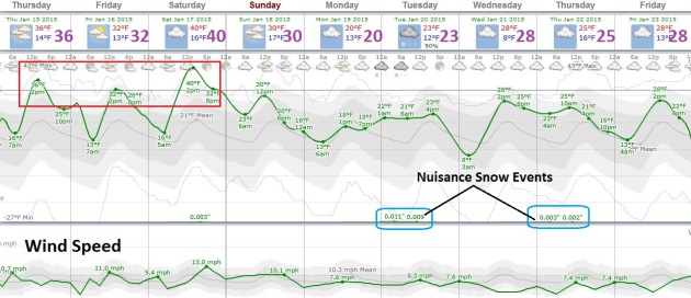
TODAY: Sunny peeks, sweet relief. Winds: West 10. High: 32
THURSDAY NIGHT: Patchy clouds. Low: 17
FRIDAY: Mostly cloudy, thawing out. High: 34
SATURDAY: Mild start, flurries, cooling off late. Wake-up: 22. High: 38
SUNDAY: Some sun, still above average. Wake-up: 18. High: 28
MONDAY: Gray with a coating of flurries possible. Wake-up: 16. High: 29
TUESDAY: Nuisance snow. Light coating? Wake-up: 20. High: 28
WEDNESDAY: More clouds than sun. Wake-up: 15. High: 26
Climate Change
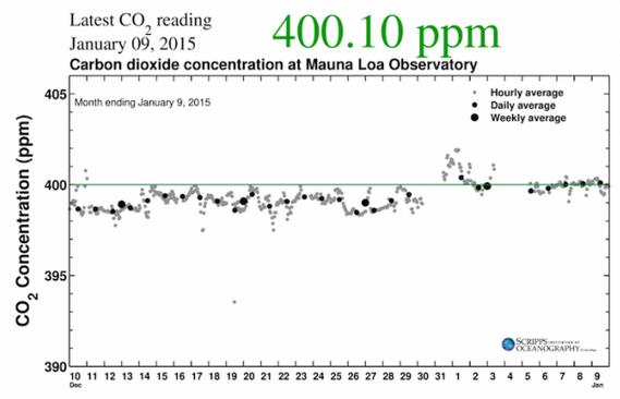
2015 Begins With CO2 Above 400 PPM Mark. Climate Central has the story and details; here's the introduction: "
The new year has only just begun, but we’ve already recorded our first days with average carbon dioxide levels above 400 parts per million,
potentially leading to many months in a row above this threshold,
experts say. The Scripps Institution of Oceanography records of atmospheric carbon dioxide levels
show that Jan. 1 was the first day of the new year above that
concentration, followed by Jan. 3 and Jan. 7. Daily averages have
continued at this level or higher through Jan. 9, though they could
continue to dance up and down around that mark due to day-to-day
variations caused by weather systems..."
Graphic credit above: "
Carbon
dioxide levels measured atop Hawaii's Mauna Loa from early December
2014 to early January 2015, when they jumped above 400 ppm." Credit: Scripps Institution of Oceanography.
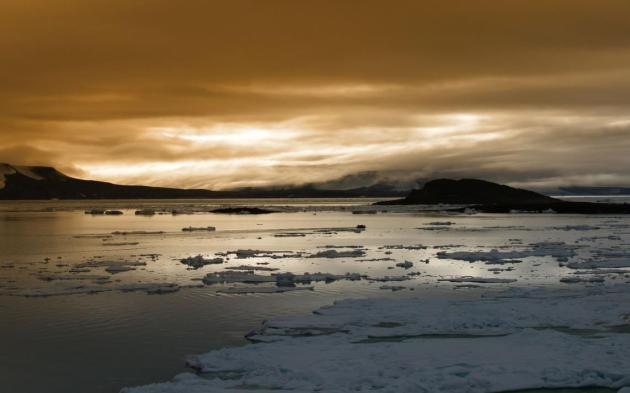
The Antarctic Ice Sheet Is A Sleeping Giant, Beginning To Stir. Dr. John Abraham at St. Thomas has the story in
The Guardian; here's a clip that got my full attention: "...
In the Southern Hemisphere, the largest player is the Western Antarctic ice sheet (WAIS). It is less stable than Eastern Antarctica
and is particularly vulnerable to melting from below by warmed ocean
waters. Scientists are closely watching the ice near the edges of the
WAIS because they buttress large volumes of ice that are more inland.
When these buttressing ice shelves melt, the ice upstream will slide
more rapidly toward the ocean waters. As reported in our paper,
according to some studies, “no further acceleration of climate change
and only modest extrapolations of the current increasing mass loss rate
are necessary for the system to eventually collapse ... resulting in 1-3
metres of sea-level rise.” And this is from just one component of the
great southern sheets..."
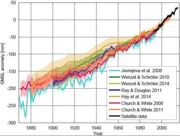
Sea Levels Are Suddently Rising Way Faster Than We Realized.
Quartz has more details: "...
What
this paper shows is that sea-level acceleration over the past century
has been greater than had been estimated by others,” says Eric Morrow, a
recent PhD graduate of Harvard’s department of Earth and Planetary
Sciences. “It’s a larger problem than we initially thought...” (Graphic:
Real Climate).
Climate Change And Intergenerational Ethics. Here's an excerpt of an Op-Ed at
The St. Louis Post Dispatch that resonated: "...
Traditional
western thought, religious and secular, has tended to see the rest of
nature as a tool for human happiness and progress, but more and more
people of every worldview are coming to understand humanity as
co-residents of the Earth, as one part of nature - the only )that we
know of) self-conscious part, and therefore having a special opportunity
and responsibility. It is time for us to lieve up that responsibility..."
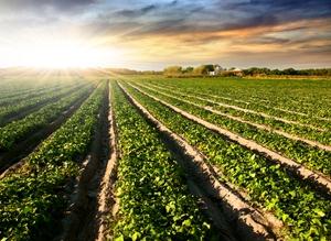
Can Monsanto Help Farmers Adapt To Climate Change? A
200 mile northward shift in corn production? It's all about the data,
and what you can do with that data. Here's an excerpt from
Mother Jones: "...
The
company is working with Bay Area data gurus to provide super-accurate
weather updates and farming advice to growers via their smartphones.
These new services can help farmers better predict climate trends that
have been shaken up by global warming—in the last couple decades,
according to Monsanto, corn production belts in the US have migrated
about 200 miles north. And they can help farmers make more efficient use
of water and potential pollutants like fuel and fertilizer..."
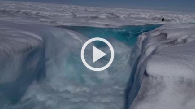
Ice Researchers Capture Catastrophic Greenland Melt. Here's a video clip and story excerpt from
The Los Angeles Times: "
Over
a few summer days in 2012, nearly all of the Greenland ice sheet
surface thawed right under the feet of a UCLA-led team of scientists.
What was not absorbed into snow quickly gathered and flowed across the
20,000-square-mile sheet, coalescing into roaring turquoise rivers. And
then most of it disappeared. Where all that water went may seem an easy
guess. But that’s just the problem with Greenland ice science -- some of
the guesses have been wrong, according to a study published online
Monday in the journal Proceedings of the National Academy of Sciences..."
Image credit above: "
In 2012, 97% of the surface of Greenland's ice sheet thawed. UCLA scientists captured the spectacular runoff."
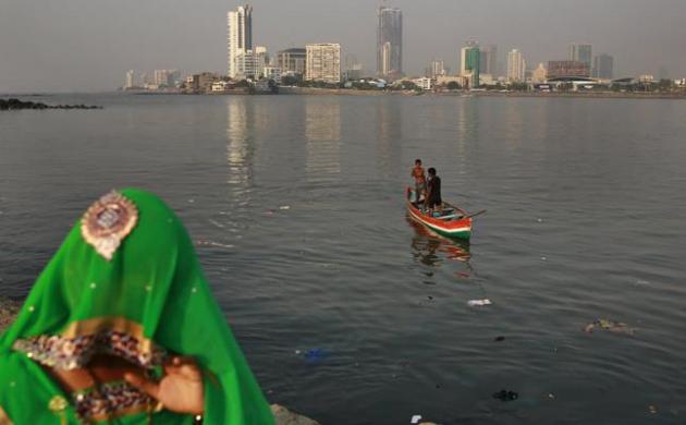
Developing Cities Hold Big Key To Climate Action.
Climate Central has the story; here's the introduction: "
Cities
— the best of which are bastions of transit networks, bike paths,
compact apartments and chirpy baristas — are growing faster than litters
of sewer rats, exacerbating their already-high hungers for energy. The
trend is so steep that a new analysis projects that urban centers will
be burning through three times more energy in the year 2050 than was the
case in 2005. But what sounds like a threat could also be viewed as an
opportunity. The new study, by five European and American researchers
and published Monday in Proceedings of the National Academy of Sciences,
pinpoints staggering potential climate benefits of smart growth,
gasoline taxes and other measures that can reduce energy demand in urban
centers, which is where a growing majority of the world’s population is
becoming concentrated and where most of its energy is used..." (Mumbai file photo: AP Photo/Rafiq Maqbool).


No comments:
Post a Comment