25 F. average high on February 1.
22 F. high on February 1, 2014.
1/2 inch of snow fell at MSP International Airport Sunday morning.
Minnesota Weather History, courtesy of the Twin Cities National Weather Service:
1996: State record low temperature set in Minnesota. With numerous media folk present, the low dipped to -60 three miles south of Tower. Governor Arne Carlson cancelled school statewide due to the cold.
1988: Temperature bottoms out at -43 at Embarrass.
1927: Spring-like temperatures on Groundhog's day. Tracy is 57 and Fairmont reaches 56.
Bored Groundhogs
"Why are we not getting any snow this winter? It's SO boring!" wrote Sylvia Goldman from Anoka. I agree. Try and make a snow angel and you'll get brush burns. While you're at it BORROW a friend's skis or sled and expect a rough ride.
Snow lovers are in a dark place. Snowfall so far this winter is half as much as last year: 5.4 inches in January, 20.4 for the winter, to date. At this rate we may wind up with 30-40 inches for the season, significantly less than average.
We're stuck in a rut; big storms sailing to the south, a relatively dry, mild Pacific influence with the coldest fronts of winter taking aim at New England, not Minnesota.
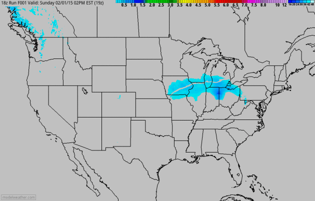
While residents of Chicago, Detroit & Boston dig out from a foot of snow we track a series of feeble clippers, each one capable of a coating. Zzzzzzzzzz.
This week trends colder than average but a thaw returns next week. Minnesota continues to dry out; a simmering low-grade El Nino should mean a mild, dry bias into early spring, but I'm not convinced this means a drought-summer is imminent.
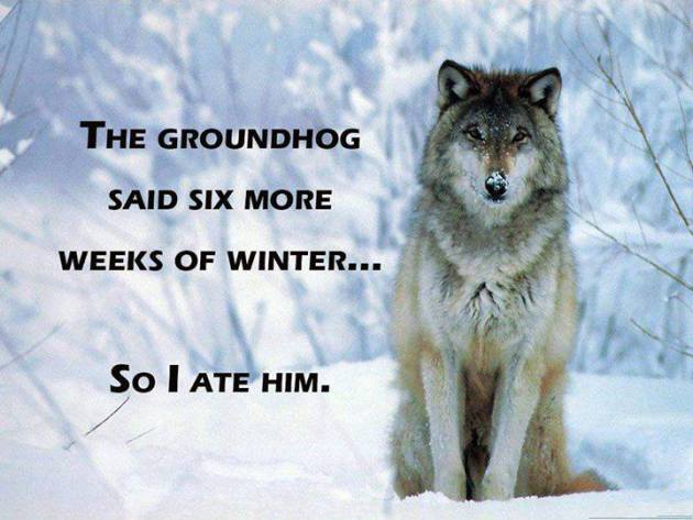
And it doesn't really matter what Punxetawney Phil says. At this latitude 6 more weeks of winter is a sure thing, but it'll be a pale imitation of last year.
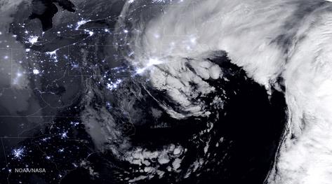
Heavy Snow Pushes Across New England.
The Patriots may have to delay their victorious flight back to BOS by
24 hours, as heavy snow sweeps eastward, near-blizzard conditions
possible for coastal New England by this afternoon. Meanwhile residents
from Davenport to Chicago to Detroit will be digging out today. 60-hour 4
km NAM accumulated snowfall product via NOAA and Aeris Weather.
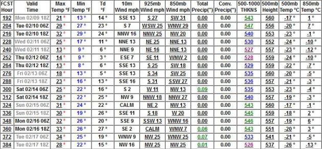
Cold, But Nothing Brutal.
Old Man Winter is pulling his punch; the high temperatures highlighted
above are considerably warmer than GFS numbers were hinting at just 1-2
weeks ago, when it looked like an extended streak of nights below zero.
According to European guidance we may not see any subzero lows into
early next week, another shot at freezing Friday before a clipper
brushes us with a coating of snow Saturday. Woo hoo!
| Blizzard Warnings For Chicago - Reaches New England Monday |
 Alerts Broadcaster Briefing: Issued Sunday morning, February 1, 2015. * Blizzard conditions impacting Chicago, about to push into Grand Rapids, Ann Arbor, Detroit, South Bend and Toledo later today. * No travel recommended from across a broad swath of land stretching from Iowa into northern Illinois, southern Wisconsin, into the Great Lakes. * Some 10-15" amounts are likely with widespread blowing and drifting of snow by Monday as winds top 35 mph. * Heavy snow reaches upstate New York and New England tonight and Monday. * Icing event in New York City, glaze icing will impact travel - sporadic power outages can't be ruled out in Tri-State suburbs. Plowable amounts of snow expected in New York City, with amounts ranging from about 4" in Manhattan to 8" from north Jersey into Westchester/Fairfield county. 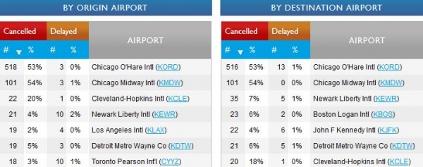 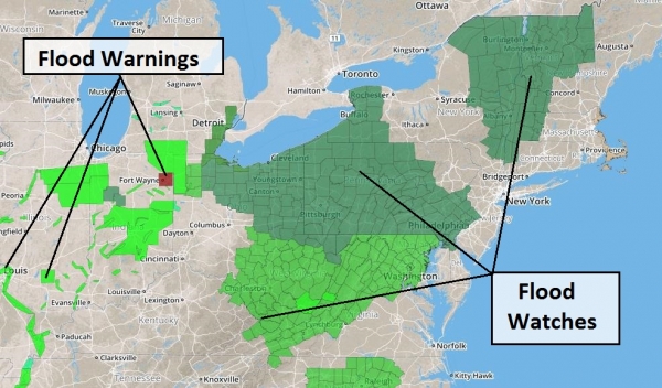 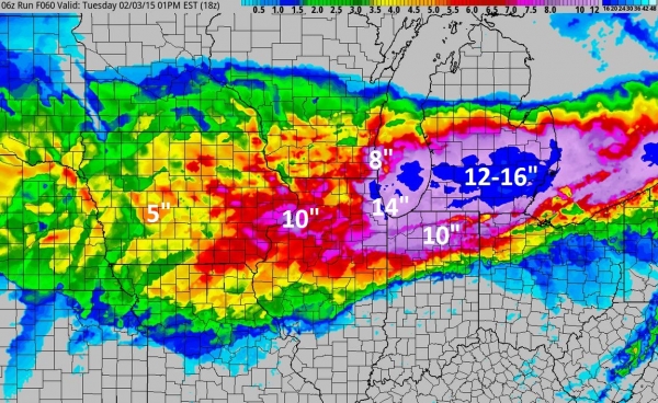 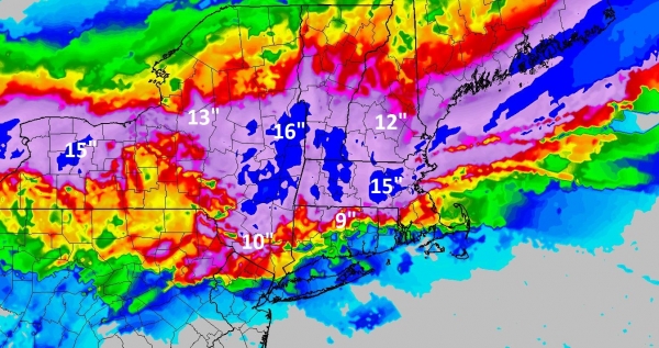 * New York City is under a Winter Storm Warning, but I expect a mix of snow and ice, with totals around 4", probably plowable, but not a crippling event with Monday temperatures at or just above freezing much of the day. Much heavier amounts are possible from Westchester County into Fairfield County, CT, where there will be more snow, less ice. 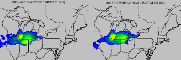 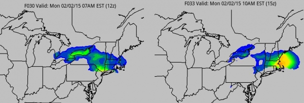 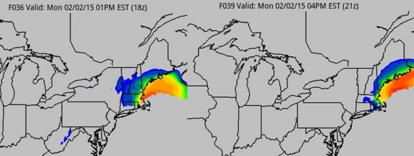 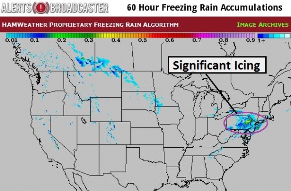 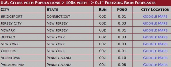 Summary: Rumor has it that February has arrived. The ground hog will see his shadow, there will be 6 more weeks of winter, especially for New England, where I see the greatest potential for colder than average temperatures and additional snow and ice storms into March. In the meantime today may be the worst travel day of winter for Chicago and Detroit. Much of New England will be a no-go zone tomorrow, with travel conditions improving on Tuesday. Good luck out there. Paul Douglas - Senior Meteorologist - Alerts Broadcaster  |
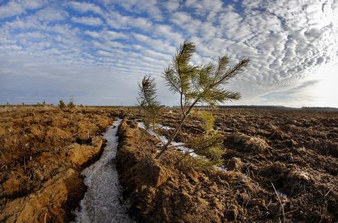
Minnesota Struggles To Slow Deforestation, Protect Water. In case you missed it in Sunday's Star Tribune, here's a link and excerpt: "Kathy
Connell never thought she’d see it in Minnesota: deforestation. But
last year she watched with dread as the pine trees surrounding her tiny
vegetable farm 60 miles northwest of Brainerd were torn out and heaped
into piles of slash. Now she fears what might come next — huge potato
fields, aerial pesticides and contaminated drinking water. Already her
neighbors are paying thousands of dollars to dig deeper wells. “To me
the earth is a God-given gift,” she said. “It’s morally wrong to poison
the water...”
Photo credit above: "A lone pine tree survived the plowing of this field south of Park Rapids." Photo: Brian Peterson.
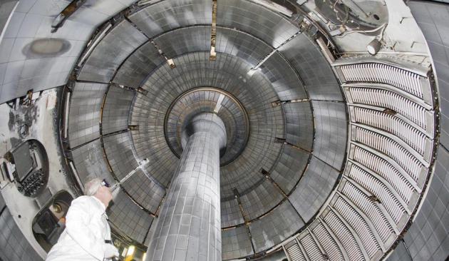
Photo credit above: "A researcher examines the National Spherical Torus Experiment."


Illustration by Jan Diehm / The Huffington Post.
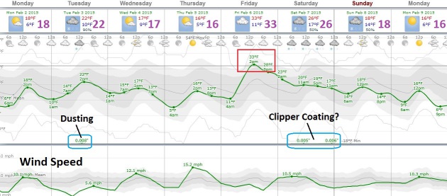
TODAY: Sunny start, clouds increase. Winds: SW 10. High: 18
MONDAY NIGHT: Mostly clear and chilly. Low: 10
TUESDAY: Another clipper, coating possible. High: 22
WEDNESDAY: Blue sky, colder smack. WC: -15. Wake-up: 14. High: 16 (falling during the day)
THURSDAY: Cold start, breezy afternoon. Wake-up: 3. High: 19
FRIDAY: Mostly cloudy and milder. Wake-up: 7. High: 32
SATURDAY: Another clipper, light accumulation. Wake-up: 24. High: 30
SUNDAY: Partial clearing, close to average. Wake-up: 20. High: 27
Climate Stories...
“That
claim is nonsensical,” said Kevin Trenberth, a climate scientist at the
National Center for Atmospheric Research (NCAR) in Boulder, Colo. “Yes,
we have always had storms in the winter, but climate change is often
the contributing factor that pushes these events over the edge to become
record-breaking.”
Here’s why: As the oceans warm due to the burning of fossil fuels, the atmosphere above can hold more moisture, which in turn fuels the creation of the most intense precipitation events.
- See more at: http://amestrib.com/news/why-bigger-snowstorms-come-global-warming#sthash.CAFsfewG.dpuf
Here’s why: As the oceans warm due to the burning of fossil fuels, the atmosphere above can hold more moisture, which in turn fuels the creation of the most intense precipitation events.
- See more at: http://amestrib.com/news/why-bigger-snowstorms-come-global-warming#sthash.CAFsfewG.dpuf

Climate Change's Bottom Line. Thanks
to Greg Page and Cargill for standing up for data, facts and science -
and not giving into ideological talking points. Here's an excerpt from The New York Times: "...Mr.
Page is not a typical environmental activist. He says he doesn’t know —
or particularly care — whether human activity causes climate change. He
doesn’t give much serious thought to apocalyptic predictions of
unbearably hot summers and endless storms. But over the last nine
months, he has lobbied members of Congress and urged farmers to take
climate change seriously. He says that over the next 50 years, if
nothing is done, crop yields in many states will most likely fall, the
costs of cooling chicken farms will rise and floods will more frequently
swamp the railroads that transport food in the United States. He wants
American agribusiness to be ready..."
* The 58 page PDF from Risky Business, "Heat in the Heartland: Climate Change and Economic Risk in the Midwest" is here.
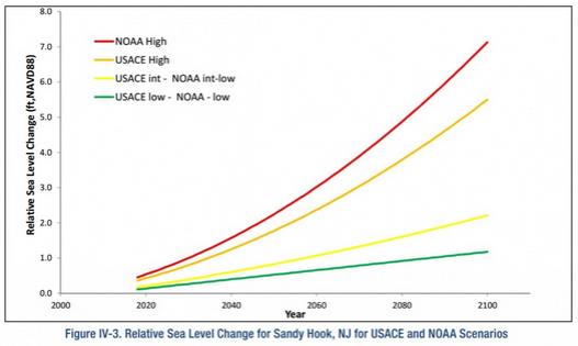
Graphic credit: "Figure from the new U.S. Army Corps of Engineers report on flood risks to the North Atlantic coast, showing sea level rise scenarios for Sandy Hook, N.J." Source: U.S. Army Corps of Engineers.
Excellent website. Plenty of useful info here. I¡¦m sending it to some friends ans additionally sharing in delicious. And certainly, thanks for your effort! Hotels in Frankfurt-Oder
ReplyDelete