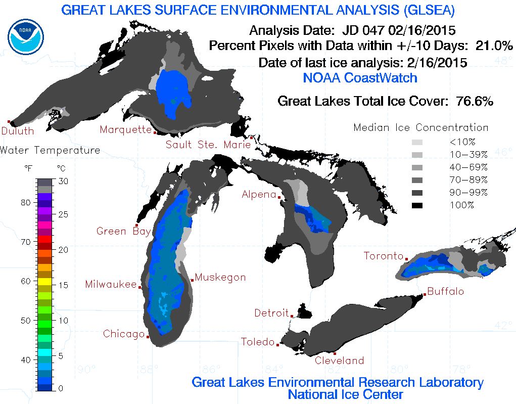
Despite the lack of widespread heavy snow across parts of the Midwest/Great Lakes, we're certainly not lacking cold weather as of late. According to NOAA's GLERL, the ice coverage as 2/16/15 was 76.6% and the 3rd highest ice coverage since 1996.
The Other Hand
By Paul Douglas
I'm pleading with my car heater (faster!) while using a credit card to chip ice off the INSIDE of my windshield, trying to hold my breath until March. Spring break seems elusive; at the rate I'm going some body parts may never thaw out entirely.
On the other hand. That hyperactive weather dude isn't ranting about T-storms on Doppler. Nobody in my family is complaining about allergies or the dew point. I can walk through the woods without a tick inspection. I'm not on my hands and knees weeding. And finally, I don't live in Boston, where 95.7 inches of snow has fallen, 58.5 inches just in February!
About one Boston blizzard's worth of snow, 24.1 inches, has fallen on the Twin Cities. We could get whacked in March but at this point I sort of doubt it. When in a drought don't forecast rain (or snow). The pattern still isn't ripe for big snows here anytime soon - a cold, dry wind swirling out of Canada keeps temperatures well below average into next week. No record lows, but 4 or 5 more subzero mornings in the next week. Long-range models signal an extended thaw by the first week of March.
We're seeing the cold without the snow. Odd. A little like limping thru half a winter.
==============
TUESDAY NIGHT: Light snow chance. Breezy and cold. Low: -5. Winds: NW 10-15. Wind Chill: -15F to -25F
WEDNESDAY: Icy wind, decreasing clouds. AM wind chill: -25F. High: 2. Winds: NW 10-15
WEDNESDAY NIGHT: Partly cloudy and cold. Low: -9. Winds: NW 5-10. Wind Chill: -15F to -25F.
THURSDAY: Blue sky, still raw. High: 6.
FRIDAY: Clipper arrives, light snow chance. Wake-up: -1. High: 20.
SATURDAY: Cold winds return. Wake-up: 12. High: 19.
SUNDAY: Quiet. Still below average. Wake-up: -1. High: 11.
MONDAY: A little warmer, nothing rough. Wake-up: -2. High: 22.
TUESDAY: Mix of sun and clouds. Wake-up: 12. High: 25.
================
This Day in Weather History:
February 18th
1979: This is one of the rare times that Lake Superior completely froze over.3
===============
Average High/Low for Minneapolis
February 18th
Average High: 30F (Record: 57F set in 1981)
Average Low: 14F (Record: -20F set in 1941)
===============
Sunrise/Sunset Times for Minneapolis
February 18th
Sunrise: 7:08am
Sunset: 5:45pm
================
Moon Phase for February 18th
New at 5:47pm (Crust of Snow Moon (Ojibwe))

=================
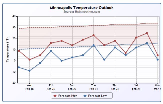
Minneapolis Temperature Trend
Well below average temperatures look to continue over the next several days with slight moderation into next week. The coldest time period appears to be midweek this week with highs struggling to get to 0F on Wednesday across much of Minnesota.
================
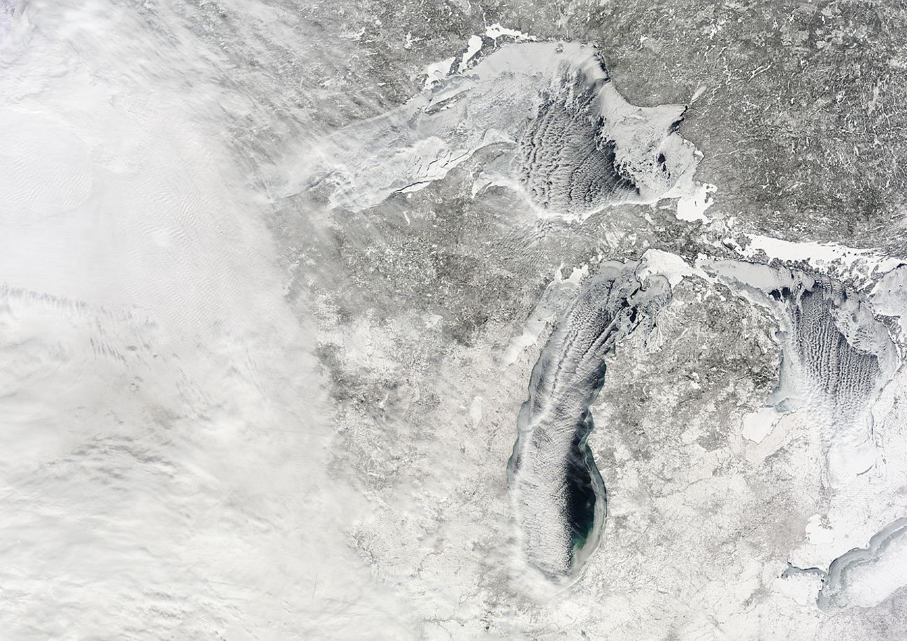
Duluth, MN
Despite the lack of snow across the Upper Midwest, the lack of cold is certainly not an issue. Take a look at the ice coverage from the western tip of Lake Superior looking NE toward the open waters (ice) of Lake Superior.

Great Lakes Ice Coverage
According to NOAA's GLERL, the Great Lakes were nearly 77% ice covered as of Monday, February 16th. Interestingly, this is the 3rd highest ice coverage since 1996 (82%). The highest ice coverage was last year at 92.5%! At the start of February, only 38% of the Great Lakes were covered with ice, now almost double!
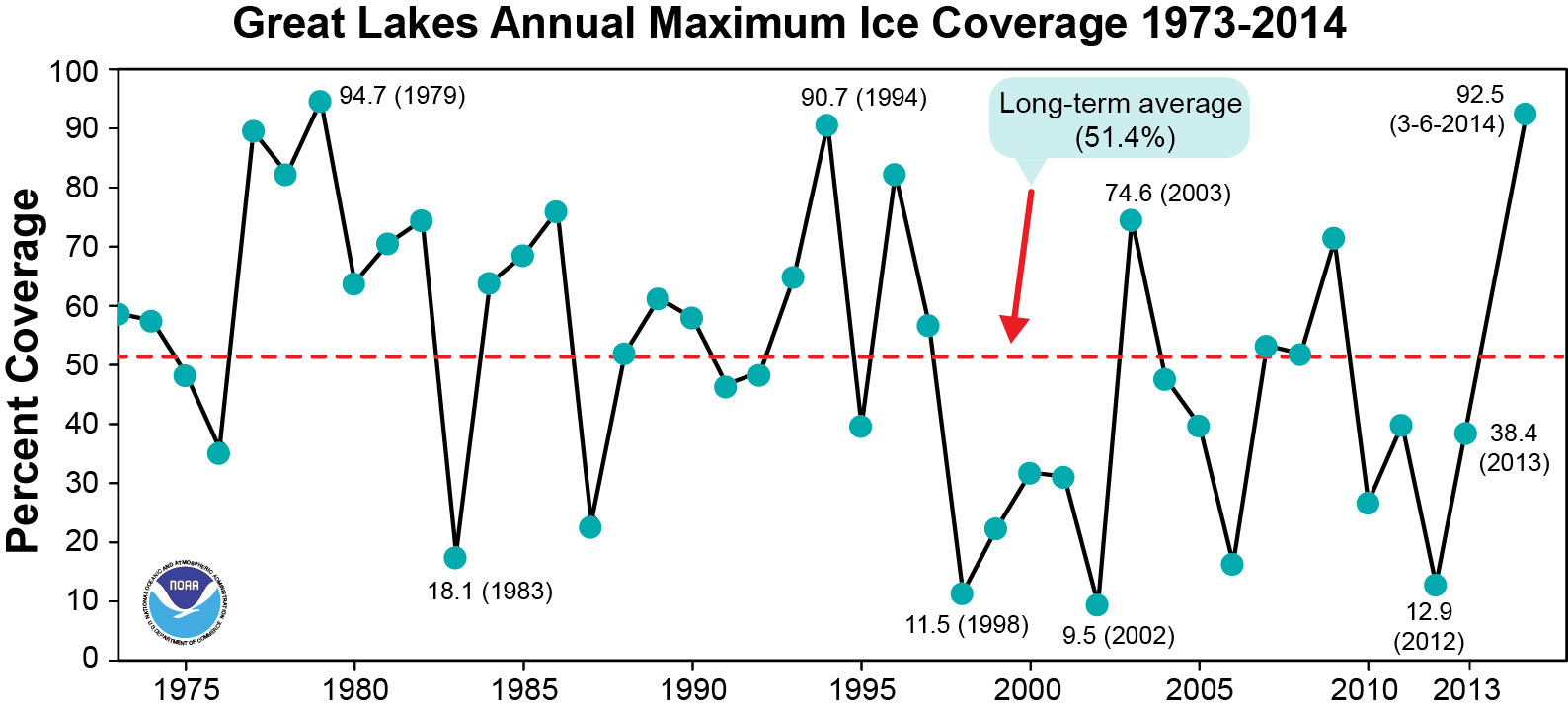
Peak Ice Coverage
A look at the peak ice coverage image below and you'll see that last year (3-6-2014) the Great Lakes had it's 3rd highest ice coverage since records began in 1973!
Making More Ice
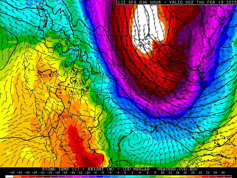
This is a pretty significant blob of cold air across the eastern two-thirds of the nation. Unfortunately, some folks across the far north will have a tough time even getting above zero for daytime highs on Wednesday. However, wind chill values will be below zero for a much wider area early Wednesday!
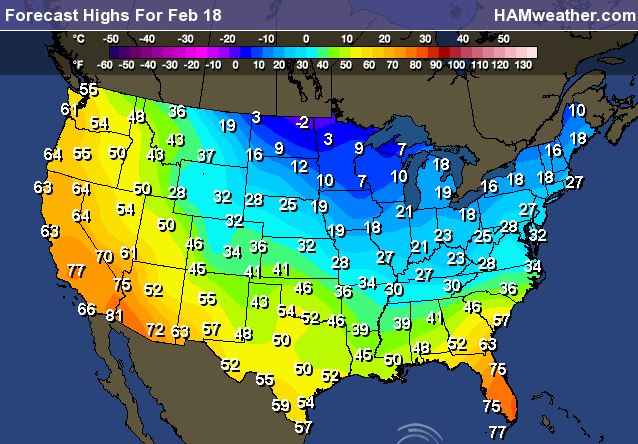
Highs Wednesday
Here's a look at what highs will look like on Wednesday. Note that several locations across the Upper Midwest will be in the single digits above and below zero, while some in the Lower Mississippi Valley will be in the 30s!
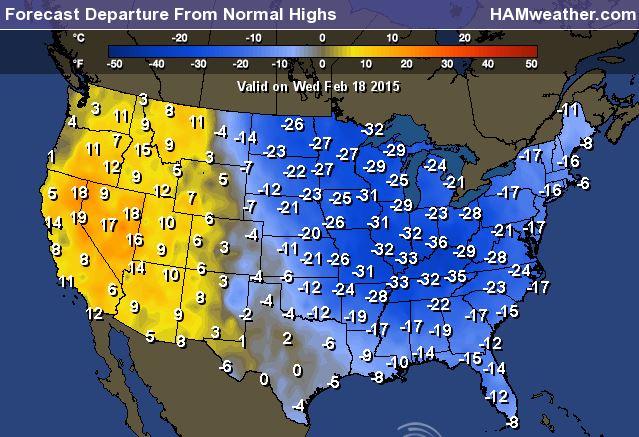
Highs From Average Wednesday
YIKES! That certainly is a big blob of cold weather isn't it? Many spots east of the Rockies will be nearly -20F to -30F below average with highs along the Gulf Coast nearly -10F to -15F below average, including New Orleans for Ash Wednesday.
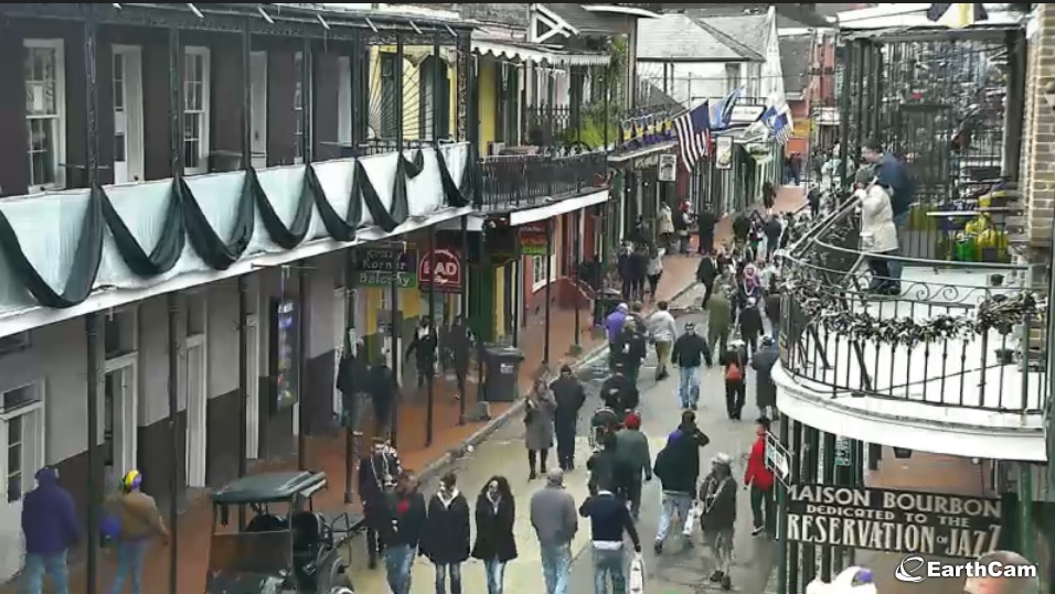
Cold Fat Tuesday
This was the EarthCam view of New Orleans during the Fat Tuesday celebrations. Note that most people were wearing coats as temperatures Tuesday morning dipped into the mid 30s with highs running nearly -15F below average!
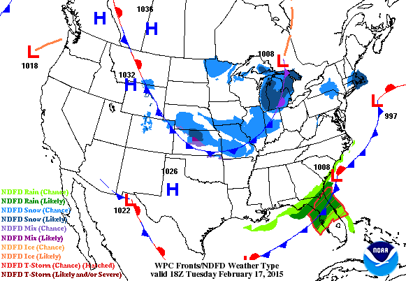
National Weather Outlook
The cold air is not only plaguing much of the eastern half of the country, but it is also helping to drive storm systems. While the latest impulse of energy isn't all that impressive, it is once again going to bring more snow to places in the Northeast.
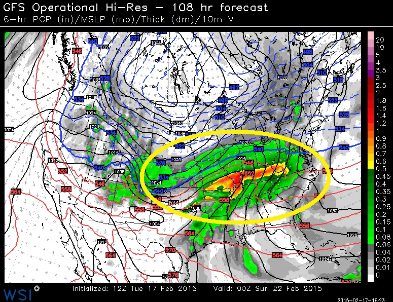
Weekend Storm System?
Take a look at what models are projecting for later this week/weekend! Another blog of significant moisture across parts of the Mississippi/Tennessee/Ohio River Valley with the potential of more snow, sleet, freezing rain and heavy rain/storms along the Gulf Coast.
Precipitation Outlook
According to NOAA's HPC, the precipitation outlook from AM Friday through AM Sunday suggests a fairly big blob of moisture in some of the same areas that just got hit with wintry weather earlier this week. It'll be interesting to see how this storm develops and how far south our cold air is as this moisture moves in.
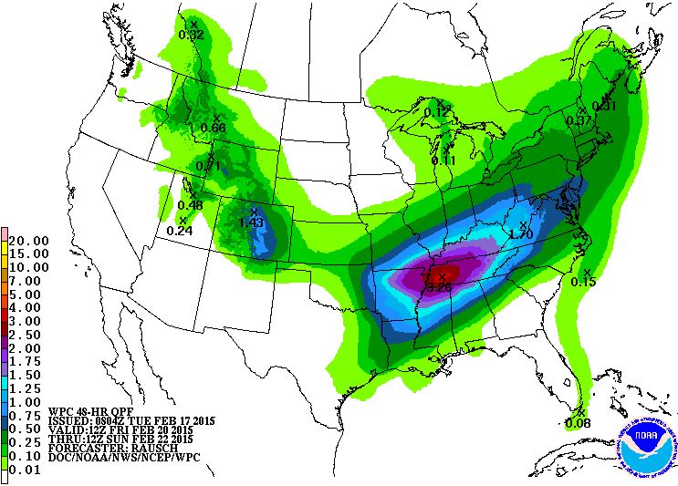
Weekend Precipitation Outlook
This is a brief glance at what we could be dealing with over the upcoming weekend. Again - the potential of a wintry mess could make for some significant travel problems across parts of the southern tier of the nation... stay tuned for more!

Thanks for checking in and have a great rest of your week! Don't forget to follow me on Twitter @TNelsonWX

No comments:
Post a Comment