32 F. high in the Twin Cities Sunday.
27 F. average high on February 8.
15 F. high on February 8, 2014.
Trace of snow on the ground at MSP International Airport.
February 8, 1899: The mercury plummets to -59 at Leech Lake Dam
50 Shades of Brown
I'm
working on a screenplay about a man so paranoid about Minnesota weather
treachery that he hides out in the Skyway System, afraid to show his
face at street-level. Far-fetched? Yes, thank God.
If 3 months ago
you had told me that we'd be staring out at brown lawns and fields in
February - while Boston was buried under 2 or 3 WINTER'S worth of snow I
would have accused you of standing too close to the Doppler. No way.
Not possible. But that's how the pattern has stalled; temporarily locked
on a track that strengthens Alberta Clippers off the coast of New
England. One after another. We get peanuts in the back of the plane
while New England gets a first-class snow buffet.
Boston's suburbs may pick up 15 to 20 inches by tomorrow morning; they're running out of places to stash snow.
Unreal.
A quiet Monday gives way to a slow-moving clipper on Tuesday capable of
2 to 4 inches of accumulation. A plowable snow? Call out the National
Guard!
I see a cold bias the next 2 weeks; a few nights below zero from Wednesday into next week.
The pattern still isn't ripe for big, sloppy southern storms. Maybe
we'll pick up a few jumbo clippers capable of white-washing my
nasty-brown yard.
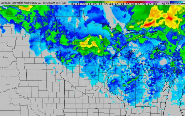 Another Fickle Clipper
.
Snow from clippers is even more unpredictable and manic than trying to
pin down snow amounts from a southern system, approaching from Colorado
or Missouri. A 20 mile north-south shift in the track can make the
difference between flurries, and a half foot of flurries. The 00z NAM
model shows the best chance of 3-4" from near Bemidji to Leech Lake and
Hibbing, maybe an inch or 2 for the metro.
 Another Northeastern Snow-Bomb
.
As much as 12-16" of snow is likely in Boston, on top of the nearly 4
feet of snow that has fallen since late January. Skiers may be snubbing
Colorado and Utah in favor of New England. At the rate we're going
avalanches may become a significant risk from Killington to Stowe and
Lake Placid. 60-hour accumulated 4 KM snowfall product: NOAA and Aeris
Weather.
 Cooling Trend
.
Again, not exactly polar, but consistently colder than average from
Thursday of this week into much of next week. A few more subzero nights
are likely, especially over the weekend, but the volume of Canadian air
pales in comparison with last winter.
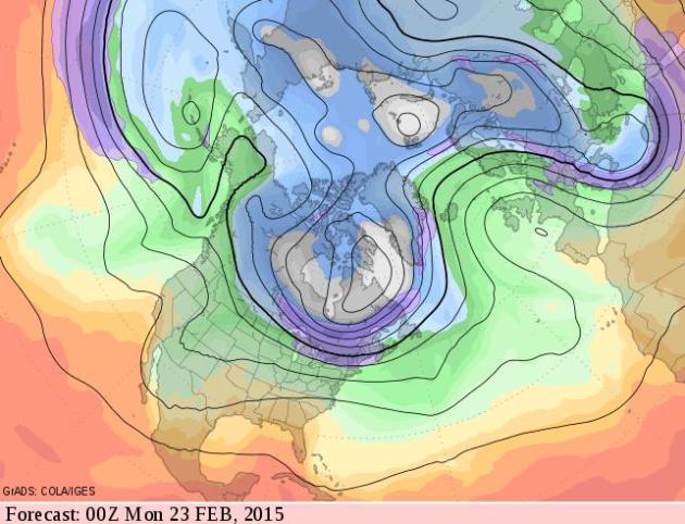 Moderately Cold for Late February.
Although the thrust of bitter air will be New England we'll see our
fair share of cold frontal passages into late February; a more zonal,
west to east flow pumping milder Pacific air inland. I wouldn't call
this winter's last gasp, but the odds of subzero weather drop off
dramatically in March with a rising sun angle. Source: GrADS:COLA/IGES.
 The Groundhog Was Right.
GFS data shows teens and 20s the latter half of February, maybe a few
days near freezing, but nothing terribly springy just yet. February is
the shortest month; before we know it it'll be March, tournament time,
spring break time. Easter eggs and thoughts of summer to come.
Alerts Broadcaster Briefing: Issued Sunday evening, February 8, 2015.
*
Long-duration snow event for New England still on track. Snow tapers
Monday night with travel conditions slowly improving Tuesday.
* I
don't expect blizzard criteria to met for an extended period, but land
and air travel will be severely disrupted over the next 24-36 hours.
*
Boston on track for at least a foot of snow, some suburbs may pick up
18" by Tuesday morning, on top of the 4 feet of snow that's fallen since
late January. We are on track for one of the 3 snowiest winters on
record for Boston.
* Governor Charlie Baker asks Massachusetts residents to stay off the road Monday.
*
In a 5 p.m. Sunday press conference, Baker asks non-emergency state
workers to stay home Monday, urges other employers to follow suit.
Source: Boston Globe.
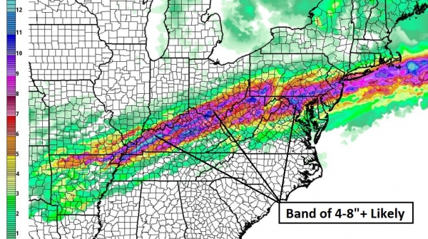
Staggering Amounts of Snow.
NOAA's NAM model prints out upwards of 16"+ for eastern Massachusetts
over the next 36 hours; Boston may be in the northeast-southwest axis of
heaviest snow. 60-hour accumulated snowfall: NOAA and Aeris Weather.
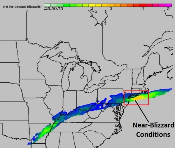
BPI: Close To Blizzard Criteria Monday Morning.
Our in-house models show conditions close to blizzard criteria Monday
morning at 10 AM (above). Visibilities may fall to 1/2 to 1/4 mile in
moderate snow at times, resulting in numerous delays and cancellations
from Hartford to Providence, Boston and Portland, Maine. BPI data: Aeris
Weather.
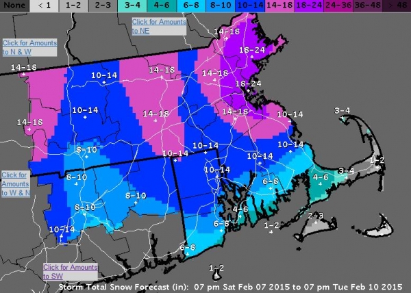
National Weather Service Snowfall Outlook.
NOAA is predicting some 18-24" amounts from Boston up the North Shore
into the Merrimack Valley. This forecast could still verify, especially
north of Boston, but I feel like final totals will wind up closer to
12-16" for downtown Boston and close-in suburbs. At some point you lose
track and it probably doesn't matter whether it's 15" or 21". It'll be
enough to turn Monday into another snow day across most of New England.
Map credit: Boston National Weather Service.
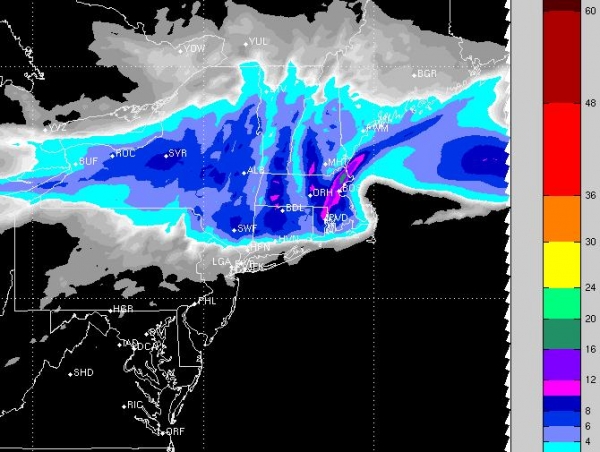
Closer To The Mark?
High-resolution models are predicting closer to 12-16" for Boston, with
10" possible in Providence. New York City will see a mix of ice and
snow with an inch or two possible from north Jersey to Westchester
County into Fairfield County, Connecticut, but the heaviest snow bands
set up well north of NYC. RPM graphic above: WSI Corporation.
Summary:
When in doubt this winter, just predict heavy snow for Boston and the
rest of New England. Odds are you'll be close to the mark. The pattern
has become temporarily locked on a track that intensifies Alberta
Clippers into Nor'easters, tapping copious moisture from the Atlantic
Ocean. 6 feet of snow in 2 weeks? That's unusual for major ski resorts
like Tahoe, Snowbird and Big Sky - it's nearly unprecedented for a major
urban area on the Atlantic coast, where warm Gulf Stream waters usually
result in rain or a mix. Not this winter.
Paul Douglas - Senior Meteorologist - Alerts Broadcaster
Many Factors Made 2014 Hottest Year in California.
It was also the warmest year, worldwide, on record, but California was
off-the-scale hot. How much of this is part of a natural cycle or
evidence of the urban heat island?
Los Angeles Daily News has a good recap; here's the intro: "
Many
blame man-made global warming. Others say it’s more about the natural
cyclical ocean currents, sea temperatures and wind patterns. Some wag
the finger at urbanized humanity — too many people, cars and concrete
heating up inside nonporous asphalt jungles. Actually, the reasons for
2014 being Earth’s warmest year since 1880 when record-keeping began are
all of the above, according to scientists and researchers. Explaining
warmer temperatures can be complex. Unfortunately, the media don’t like
to report yes-but answers..."
An Exclusive Look At Sony's Hacking Saga. Vanity Fair has more details on the chronology of the largest corporate hack in history; here's the prologue: "
The
devastating moment that Amy Pascal and Michael Lynton learned Sony had
been taken hostage by vicious cyber-criminals targeting The Interview,
was just the beginning of the drama. Mark Seal speaks with Seth Rogen
and Evan Goldberg for an inside account of Hollywood caught in the
crosshairs..."
Image credit above: "
Seth Rogen,
Sony Pictures co-chairman Amy Pascal, North Korea leader Kim Jong Un,
Sony Pictures C.E.O. Michael Lynton, and James Franco."
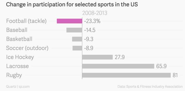
Americans Are Too Blinded By Fandom To Save Football From Destroying Itself.
Yeah, those concussions and brain injuries are unfortunate, now get out
of the way of my TV screen while I turn up the volume on the game. Not
sure what to make of this, but a story at
Quartz is worth reading - here's a clip: "...
Participation
has been waning for years. Between 2008 and 2013 the number of people
playing tackle football, the full-contact version of the sport, declined
by 1.9 million people, a drop of 23%, according to the Sports Industry
and Fitness Association. There has even been an exodus from safer
variants like “flag” football (down 21%) and touch football (down 32%)..."
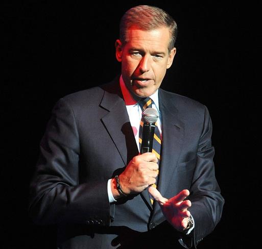
Why Did Brian Williams Lie? Or
misremember, my new favorite word. Maybe it all stems from a desire not
to disappoint, an almost subconscious desire to tell a better story,
according to a story at
POLITICO; here's an excerpt that caught my eye: "...
Alas,
the human tendency to juice our stories is universal, and it’s a
temptation that some journalists find impossible to resist. When we tell
our personal stories, we tend to add dramatic pauses that will build
suspense. In each retelling, we tend to incorporate into it the
reactions of the last audience, escalating the drama that got a good
reaction, tamping down the events that dragged, and making up stuff to
further engage our audiences. We supplement and reshape our stories both
subconsciously and deliberately, because there is no public shame like
the public shame that follows the telling of a boring tale..."
Photo credit: Brad Barket/Invision/AP, File.
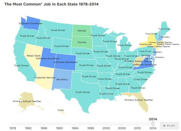
Map: The Most Common* Job In Every State. According to
NPR's Planet Money I will soon be driving a truck. Don't laugh - so will you. Here's an excerpt from a fascinating story: "...
We
used data from the Census Bureau, which has two catch-all categories:
"managers not elsewhere classified" and "salespersons not elsewhere
classified." Because those categories are broad and vague to the point
of meaninglessness, we excluded them from our map..."
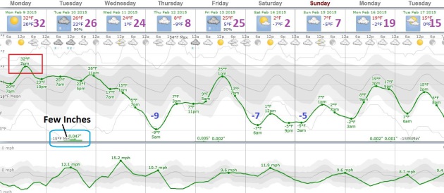
TODAY: More clouds than sun, quiet. Winds: NE 5. High: 30
MONDAY NIGHT: Clouds increase late. Low: 21
TUESDAY: Another clipper. 1-2" possible, more north of MSP. High: 31
WEDNESDAY: Windy, turning colder again. Wake-up: 16. High: 18, falling during the day.
THURSDAY: Blue sky. Still feels like winter. Wake-up: -1. High: 12
FRIDAY: Clouds, few flurries. Wake-up: 5. High: 22
SATURDAY: Reinforcing shot of cold air. Wake-up: -4. High: 9
SUNDAY: Mix of clouds and sun, brisk. Wake-up: -2. High: 14
Climate Stories....
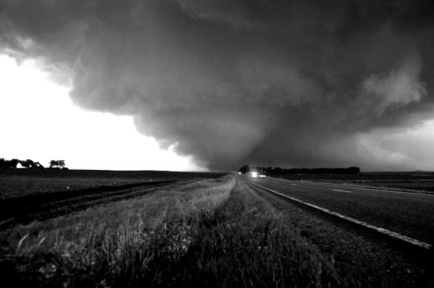
Global Warming May Spawn More Southeast U.S. Tornadoes. Live Science has the details of new research and projections; here's an excerpt: "...
Researchers examined how global warming
will affect severe weather during the heart of tornado season — March,
April and May. They found that while the yearly tornado total will climb
by 2080, the number of tornadoes will also vary wildly from year to
year. That's because sometimes, the weather will get stuck in a pattern
that favors tornadoes,
and sometimes, conditions will stymie stormy weather, according to the
report, published Jan. 15 in the journal Climatic Change..."
The Global Heat Is On For Congress. An Op-Ed at
The Prior Lake American resonated with me, a terrific summation of the threat...and opportunity. Here's an excerpt: "...
Ronald
Reagan’s Secretary of State George Schultz is a Citizens’ Climate Lobby
(CCL) advisory board member. CCL is a nonprofit and nonpartisan group
focused on national policies to address climate change. Schultz supports
CCL’s 100-percent revenue-neutral carbon fee and dividend plan while
Art Laffer, economic advisor to President Reagan, calls it a
“no-brainer.” The fee and dividend plan is very simple. Place a steadily
rising fee on the carbon dioxide content of fossil fuels, enact border
adjustments to ensure fairness and competition for American businesses,
and return 100 percent of the revenue to American households to offset
energy price increases..."

No comments:
Post a Comment