73 minutes of additional daylight since December 21.
19 F. high in the Twin Cities Thursday.
26 F. average high on February 5.
4 F. high on February 5, 2014, after waking up to -5 F.
2" snow on the ground at MSP International Airport.
February 5, 1994: The national low was at Tower with -41.
Real Entrepreneurs
Farmers
are the original entrepreneurs, risking their capital and know-how for
an uncertain return. Weather is obviously a huge factor, the prevalence
of drought; extreme heat can devastate yields. Nothing is guaranteed.
And farmers tend to take nothing for granted in their quest to a). feed
the world, and b). stay in business.
Wednesday Winfield (Land
O'Lakes) invited me to Mankato and Brookings, South Dakota to talk about
the data and the trends. Ignore either and you're out of business.
Reasonable people can debate the cause, but there's little doubt weather
patterns are changing and morphing: intensity of summer rain, length of
the growing season, higher dew points, challenges with soil moisture
and nitrogen run-off, and "weather whiplash", going from drought to
flood back to drought at a rapid rate that would have been unthinkable a
generation ago.
The farmers I talked with acknowledged that it's
not their grandfather's weather anymore. They promised to keep an open
mind, which is as much as anyone can ask for.
Minnesota is drying
out; moisture from the Gulf of Mexico unable to able to push this far
north, leaving us with gently-used clippers, which whip up more wind
than snow.
This weekend's clipper passes well north, pulling mild 30s back into Minnesota - another welcome thaw is imminent.
NOAA
predicts a 50-60 percent chance of El Nino setting up by late winter
and spring. The Pacific Ocean can't seem to make up it's mind. Just like
the fickle ocean of air floating above our heads.
A Deepening Dry Rut. Here are a few of the highlights from this month's
HydroClim Update from the Minnesota DNR:
- January
monthly precipitation totals were below historical averages in nearly
every Minnesota community. In many locales, a monthly precipitation
totals were less than one-half of the long-term average.
- Snow
depths are highly variable across Minnesota. Less than three inches of
snow cover is on the ground across large sections of west central,
central, and southwest Minnesota. Whereas, much of northeastern
Minnesota, inland from Lake Superior, has a foot or more of snow cover.
Snow depths are well below median for this time of the year in most
Minnesota communities.
- The U. S. Drought Monitor indicates that Abnormally Dry
conditions exist over nearly all of Minnesota, the result of a dry late
summer and autumn, and a snow-sparse winter. Two small areas of west
central and north central Minnesota are placed in the Moderate Drought category....
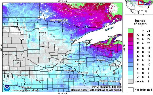
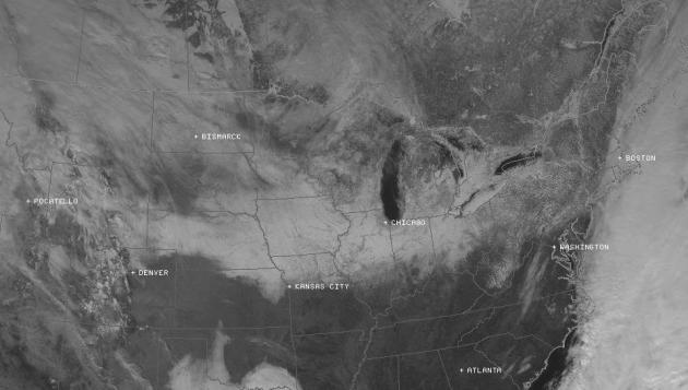
Snowy Stripe.
The brightest white, corresponding with the deepest snow, runs from
Nebraska and Iowa to Chicago, Detroit and Boston. Yesterday's midday
visible satellite image courtesy of NOAA and
Simuawips.
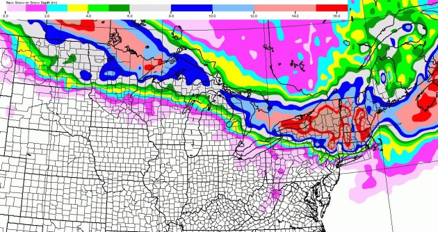
One Hefty Clipper.
Although the GFS pushes snow farther south into Minnesota than NAM or
ECMWF the overall trend seems to be on track, with the greatest
potential for heavy snow from the Minnesota Arrowhead into New England
by Monday and Tuesday. Just what Boston needs, more snow.
Another Near-Miss.
Last week it was an historic snowfall from Des Moines to Chicago,
Detroit and Boston. The next system pushes a swath of heavy snow across
Manitoba and Ontario, just brushing the Minnesota Arrowhead with
plowable amounts over the weekend. Source: NOAA and Aeris Weather.
West Coast Soaking.
4 km NAM guidance prints out some 6-10" precipitation amounts for
northern California and the coastal ranges of the Pacific Northwest;
some valuable precipitation on the way from a powerful Pacific storm.
Mudslides and flash flooding may result from this system as well in the
coming days. Source: Aeris Weather.
Trending Close To Average.
In spite of another noticeable temperature dip next Wednesday into
Thursday nothing too forbidding is shaping up looking out 7-10 days,
based on European model guidance. Highs brush freezing today and
Saturday, possibly rebounding into the 30s again a week from Saturday.
You'll be shocked to hear this: no significant storms in sight. When in a
drought don't predict rain...or snow.
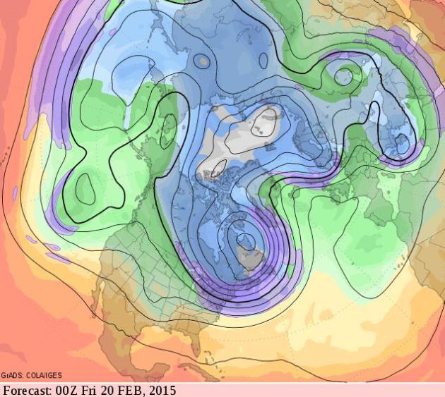
New England Bears The Brunt of Bitter Air.
500 mb predicted winds, valid Thursday evening, February 19 shows the
thrust of numbing Canadian air surging into the northeastern USA, with
gradual moderation from Minnesota south and west by the final third of
February. GFS forecast data: GrADS:COLA/IGES.
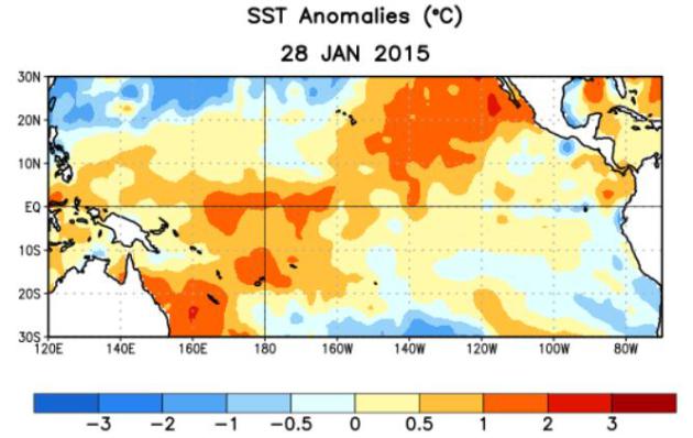
50-60% Probability Of El Nino.
We're still in a holding pattern, but the ingredients have not
converged for a full-blown (declared) El Nino in the Pacific. That said,
an El Nino Watch is still in effect for late winter and spring in the
northern hemisphere. All the details courtesy of
NOAA CPC.
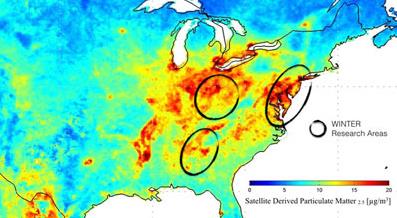
Cold Facts of Air Pollution. I thought this story from
UCAR in Boulder was interesting; here's an excerpt: "...
This month, a major air quality project known as WINTER (Wintertime Investigation
of Transport, Emissions, and Reactivity) takes to the air to examine
pollutants across the Northeast urban corridor, Ohio River Valley, and
Southeast Mid-Atlantic. Scientists will home in on wintertime emissions
from urban areas, power plants, and farmland, and seek to better
understand the chemical processes that take place as pollutants move
through an atmosphere that is not only colder but also darker than in
summer..."
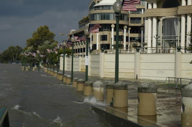
Study: Heart Attacks, Strokes Spiked In Hurricane Sandy Ravaged Areas.
NewsWorks
has the results of an interesting study, showing how extreme stress
brought on by a major storm can have physical implications for
survivors; here's an excerpt: "
In Hurricane Sandy's wake, life
became chaotic, with thousands displaced, neighborhoods flooded and
without electricity for days, and a palatable sense of fear
and uncertainty. There were also serious health consequences, a Rutgers
University research study found. Hurricane Sandy had a "significant
effect" on cardiovascular events in the high-impact areas of New Jersey
during the two weeks after the Oct. 2012 storm..."
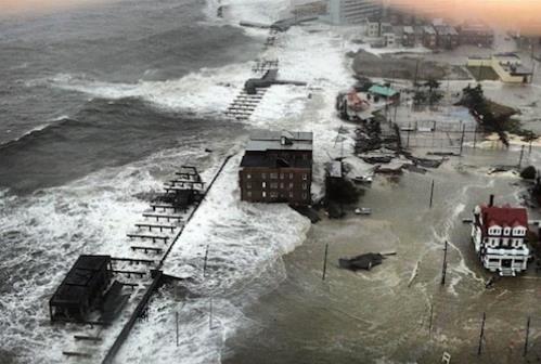
What If Sandy's Surge Swamped Washington D.C.? Climate Central
takes a look at what the combination of rising sea level, land
subsidence and a major storm pushing a surge into the Chesapeake Bay
could mean for our nation's capital. Here's an excerpt: "...
Sea
level rise driven by global warming was a factor in Sandy’s ability to
inundate New York. Water levels near New York City have risen by 1.5
feet since the mid-19th century, in part because of the expansion of
warming ocean waters and ice melt. So any storm surge entering the area
now is acting on top of those already higher waters,
which will keep climbing as the planet’s temperature keeps rising. The
same is true of D.C., which is in an area that has seen 6 to 8 inches of
sea level rise since 1960, according to the Environmental Protection Agency. Global sea level rise by 2100 is estimated to be between 10 inches and a several feet, according to the Intergovernmental Panel on Climate Change, and the Chesapeake Bay area has been rising faster than the global average..."
Photo credit above: "
Washington Harbor encroaches on the shore in September 2003 as storm surge from Hurricane Isabel raises water levels." Credit: FEMA/Liz Roll.
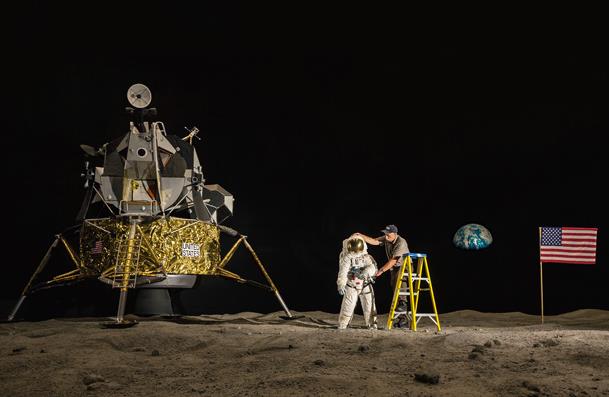 Why Do Many Reasonable People Doubt Science? National Geographic
has a thoughtful look, from faked moon landings to vaccines and climate
change, there is manufactured doubt everywhere you look; here's a clip:
"...We live in an age when all manner of scientific
knowledge—from the safety of fluoride and vaccines to the reality of
climate change—faces organized and often furious opposition. Empowered
by their own sources of information and their own interpretations of
research, doubters have declared war on the consensus of experts. There
are so many of these controversies these days, you’d think a diabolical
agency had put something in the water to make people argumentative
Why Do Many Reasonable People Doubt Science? National Geographic
has a thoughtful look, from faked moon landings to vaccines and climate
change, there is manufactured doubt everywhere you look; here's a clip:
"...We live in an age when all manner of scientific
knowledge—from the safety of fluoride and vaccines to the reality of
climate change—faces organized and often furious opposition. Empowered
by their own sources of information and their own interpretations of
research, doubters have declared war on the consensus of experts. There
are so many of these controversies these days, you’d think a diabolical
agency had put something in the water to make people argumentative..."
(Image: Kennedy Space Center).
Life Will Never Be Fair. Get Over It. Here's an excerpt from a story at
The Guardian: "...
The
world, obviously, is a manifestly unjust place: people are always
meeting fates they didn’t deserve, or not receiving rewards they did
deserve for hard work or virtuous behaviour. Yet several decades of research
have established that our need to believe otherwise runs deep. Faced
with evidence of injustice, we’ll certainly try to alleviate it if we
can – but, if we feel powerless to make things right, we’ll do the next
best thing, psychologically speaking: we’ll convince ourselves that the
world isn’t so unjust after all..."
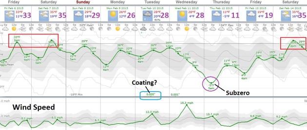
TODAY: Gray, a little freezing drizzle. Winds: SE 10. High: near 30
FRIDAY NIGHT: Cloudy, a touch of ice possible. Low: 20
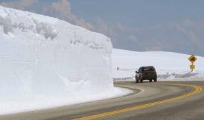
SATURDAY: Cloudy, relatively mild. Plowable snow Minnesota Arrowhead. High: 33
SUNDAY: Mostly cloudy, close to average. Wake-up: 24. High: 29
MONDAY: More clouds than sun. Wake-up: 20. High: 30
TUESDAY: Another clipper? Chance of slushy snow. Wake-up: 25. High: 32
WEDNESDAY: Windy, turning colder again. Wake-up: 21. High: 23
THURSDAY: Blue sky, touch of January. Wind chills dipping to -20. Wake-up: -3. High: 13
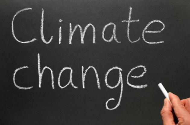
Climate Stories....
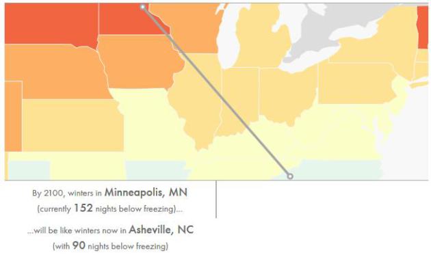
Winter Loses Its Cool. Climate Central
looks at the temperature trends, and where we may be heading if
attempts to lower greenhouse gas emissions fail; here's a clip: "...
Climate
models project that freezing temperatures will become even less
frequent as greenhouse gas emissions further increase global
temperatures. What will these warming winters feel like? For our Winter
Loses Its Cool interactive we have projected the number of nights below
freezing for the end of this century for 697 cities, and then showed
which U.S. city currently experiences that number of freezing nights.
Several striking examples are highlighted above, but explore the
interactive to find out how the cold season will be affected in your
city..."
No, Climate Models Aren't Exaggerating Global Warming.
The Washington Post has an interesting analysis of the so-called "temperature plateau"; here's an excerpt: "...
While many models didn’t predict the relatively modest surface-warming “hiatus,” it’s
not because they’re biased in favor of greenhouse-gas emissions’
warming effects. Rather, researchers report in Nature, these computer
simulations just struggle to predict “chaotic” (or random) short-term
changes in the climate system that can temporarily add or subtract from
CO2 emissions’ warming effects..."
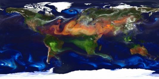
Image credit above: "
High-resolution
global atmospheric modeling run on the Discover supercomputer at the
NASA Center for Climate Simulation at Goddard Space Flight Center." (NASA).
The End And The Beginning Of The Arctic. Here's a clip from a story documenting the widespread changes taking place in the Arctic, courtesy of
The Arctic Journal: "...
What
happens in the Arctic matters. The ecological, cultural and economic
shifts that are currently underway will not only alter the lives of the
Inuit, Gwich’in, Nenets and other aboriginal people who live there, they
are likely to affect mid-latitude weather patterns, the migrating birds
we see, the air we breathe, the fuel we burn and the way in which we
transport goods from one continent to another. The question then
becomes, how do we understand and manage the end of the Arctic as we
know it so we are prepared to deal with the new Arctic that is
unfolding?..."
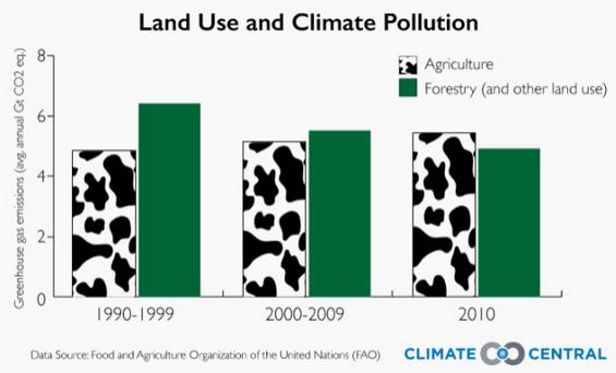
Farming Is Now Worse For The Climate Than Deforestation. A story at
Quartz made me do a double-take; here's an excerpt: "...
Efforts
such as these to slow deforestation have delivered some of humanity’s
few gains in its otherwise lackadaisical battle so far against global
warming. A gradual slowdown in chainsawing and bulldozing, particularly
in Brazil, helped reduce deforestation’s annual toll on the climate by
nearly a quarter between the 1990s and 2010.
A new study describes how this trend has seen agriculture overtake
deforestation as the leading source of land-based greenhouse gas
pollution during the past decade..."
Temperatures Rise As Climate Critics Take Aim At U.S. Classrooms. Bloomberg Business has the article; here's a snippet: "...
If
the coalition had its way, any reference to “global warming,” melting
polar ice caps or rising sea levels would be excised from textbooks, or
paired with dissenting views. Phrases such as “consensus science” and
“settled science” should be avoided, the group warned in letters to
publishers last year, as they suggest a “political agenda.” So far, the
campaign has had only limited results. One publisher deleted a reference
to global warming and others ignored White’s appeals. The group isn’t
done, however..." (File image: Shutterstock).


No comments:
Post a Comment