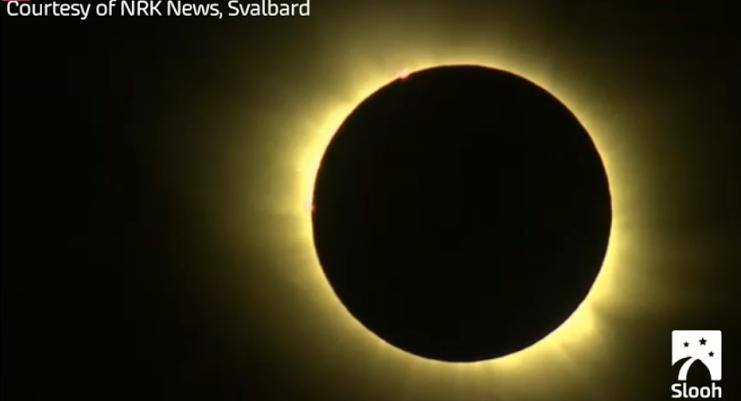
WOW! This was the view from Svalbard and the Faroe Islands early Friday morning during a total solar eclipse. I happened to tune into Slooh just before totality... what an amazing sight! Glad I was able to watch it! Think of how strange it would have been to see something like this in our ancient ancestry days! They must have thought the world was ending prior to knowing what exactly what was going on!
(image courtesy: NRK News, Svalbard and Slooh)
Signs of Spring
By Todd Nelson
While some folks wait for the first daffodil to pop out of the ground or the cardinals to sing 'cheer, cheer, cheer' - I await a phone call from a southern Texas area code. My grandparents call me every year for a forecast wanting to know what the weather will be like for their ride back home to Wisconsin.
Over the next month, flocks of snow birds will begin their migration north. Golf rates drop in Arizona by mid April as temperatures rise and the population dwindles in retirement communities. Many head back north to enjoy what the Upper Midwest offers in the warmer months.
One week ago, we were being teased by Mother Nature. Highs were in the 50s, 60s and 70s; more typical of late April/early May. Spring Fever was running rampant across the Upper Midwest. Today, temps are running a little closer to where we should be. Yes, this is what March is typically like in Minnesota.
Interestingly, March is the 3rd snowiest month for the Twin Cities, averaging a little more than 10". This year, we've only seen about 2", nearly 6" below average! A spring limbo unfolds through next week. Beneficial rain/snow chances develop, which will the drought a bit. - Todd Nelson
=================
FRIDAY NIGHT: Partly cloudy and cooler. Low: 25 Winds: SW 5-10
SATURDAY: A little more sun. Temperatures closer to average. High: 44. Winds: NNW 10
SATURDAY NIGHT: Clouds thicken. Low: 26. Winds: NE 5-10
SUNDAY: Chance of a rain/snow mix. Light snow accumulations? High: 39
MONDAY: A little early slush? Clouds linger. Wake-up: 29. High: 42
TUESDAY: Warmer. chance of rain. Wake-up: 30. High: 48
WEDNESDAY: Cooler. Light rain/snow mix. Wake-up: 35. High: 46
THURSDAY: Lingering clouds, few flakes? Wake-up: 31. High: 41
FRIDAY: Clearing and cooler. Wake-up: 26. High: 38.
=================
This Day in Weather History
March 21st
1953: Tornado hits the northern St. Cloud area with high winds from martin to Stearns County.
==================
Average High/Low for Minneapolis
March 21st
Average High: 44F (Record: 76F set in 1938)
Average Low: 26F (Record: -8F set in 1965)
=====================
Sunrise/Sunset Times for Minneapolis
March 21st
Sunrise: 7:14am
Sunset: 7:37pm
=====================
Moon Phase for March 21st at Midnight
1.9 Days Since New Moon
==================
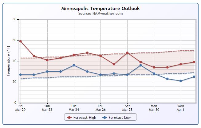
Minneapolis Temperature Trend
Back to normal... Yes, normal temps would have felt incredibly nice during the month of February when we endured 12 sub-zero nights during the month of February! We typically average around 5 sub-zero nights during the month! The tease we had last week with highs in the 50s, 60s and 70s across parts of the state made more normal March weather this week feel quite cool...For those of you who want that type of weather to return, we may have to wait a while as extended forecasts keep us a little cooler through early April.
=======================
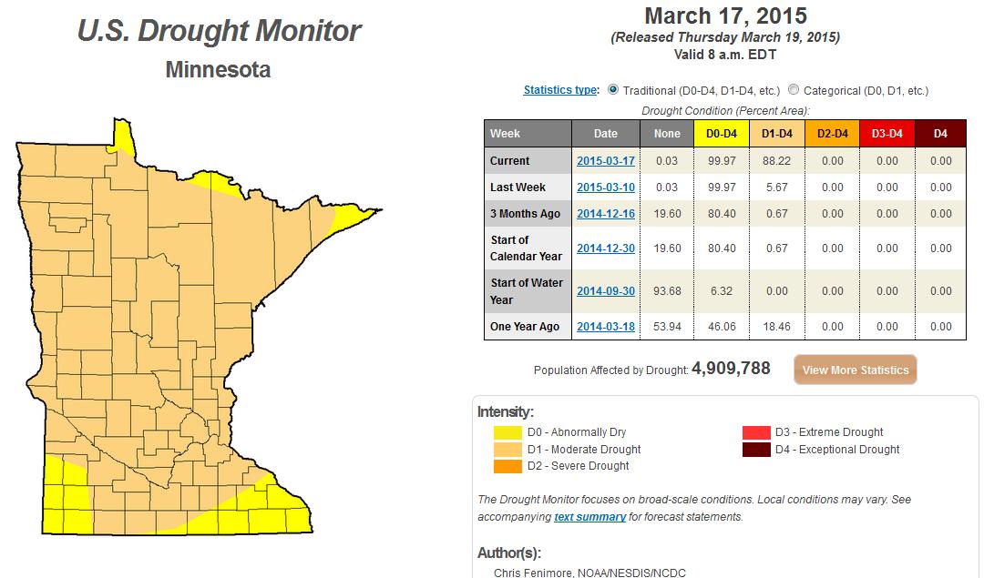
Minnesota Drought
No doubt it has been dry across the state over the past several weeks. According to the most recent U.S. Drought Monitor, Minnesota went from near 6% MODERATE drought last week to near 90% MODERATE drought this week!
Saturday Weather Outlook
The first weekend of Spring across the Upper Midwest looks MUCH cooler than what we were dealing with last weekend. Temperatures will hold in the 20s and 30s near the international border, while temperatures across southern MN will warm into the 40s to near 50. A light north to northwesterly breeze will make it feel a little cooler, but not too bad.
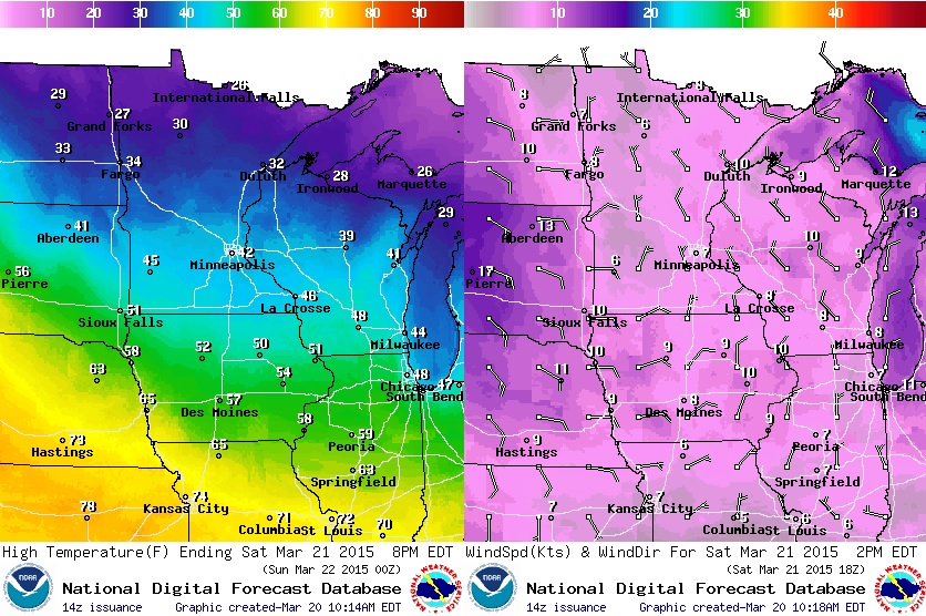
Saturday Weather Outlook Cont.
The good news is that Saturday looks like a fairly sunny day across the region. One clipper departs through the Great Lakes, while another clipper looks to take shape across the North Dakota late in the day. With that said, clouds will thicken PM Saturday, but precipitation should hold of until Sunday.
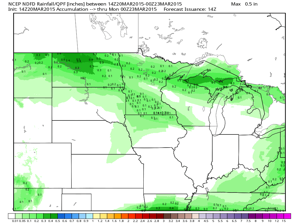
Midwest Precipitation Outlook
Precipitation potential through looks fairly light across the Midwest with only up to a couple of tenths of an inch possible across parts of Minnesota through PM Sunday. However, heavier precipitation potential looks to be in place through the early part of next week...
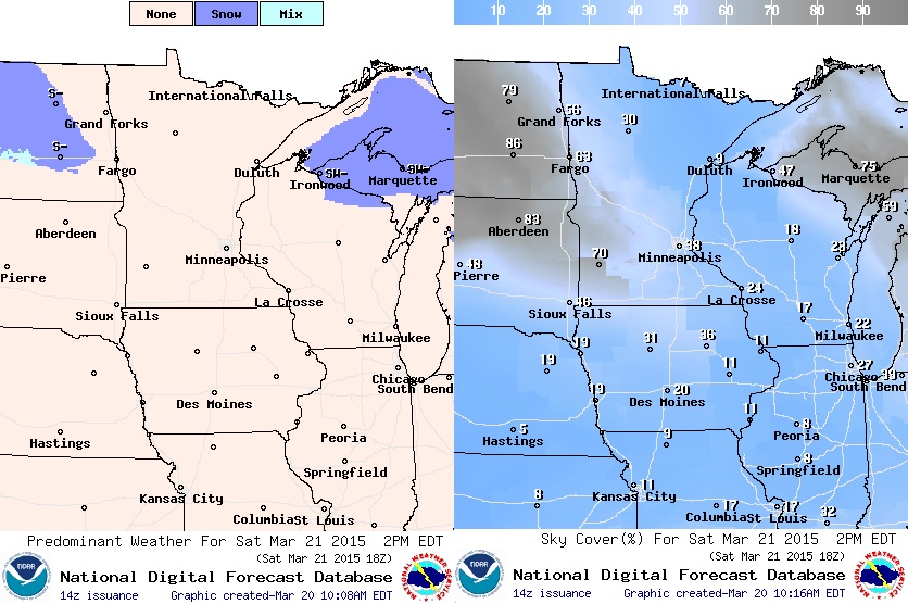
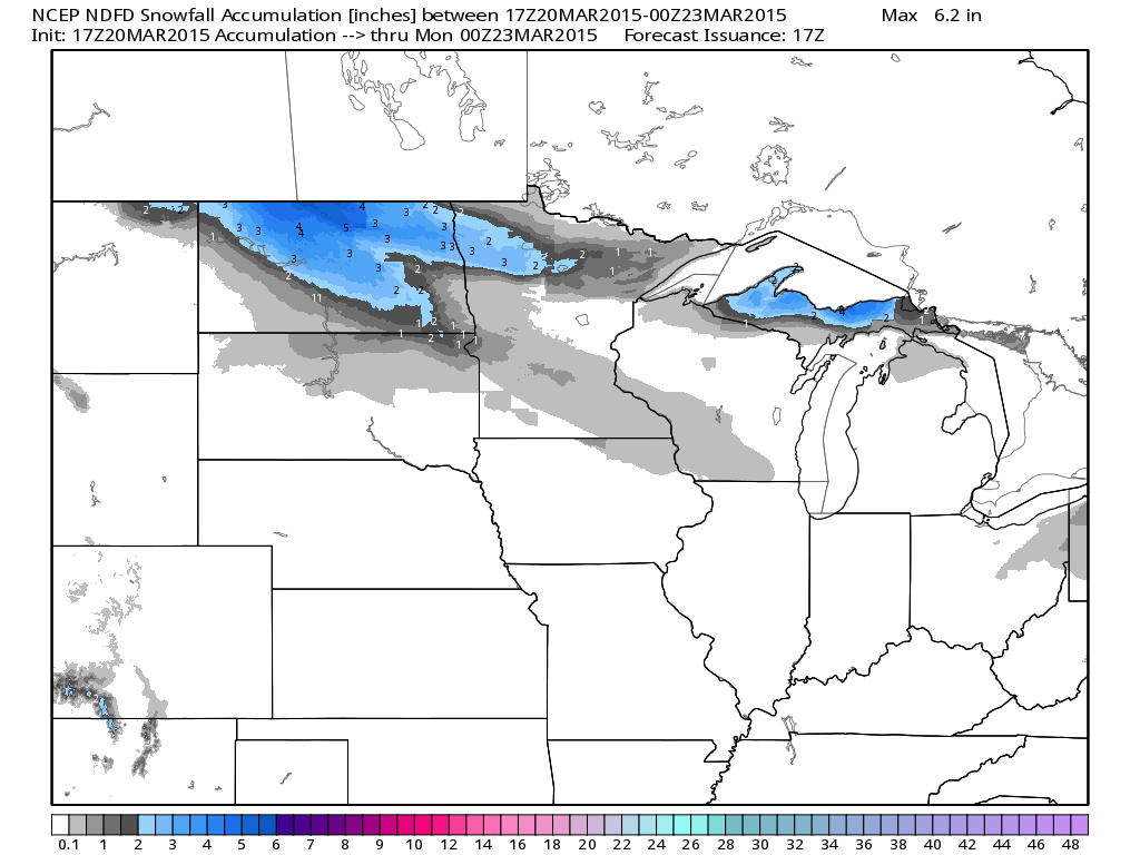
Snowfall Potential?
These clippers will dive out of Canada with a little bit of cooler air, so precipitation looks to fall in a wintry fashion for some. Below is the snowfall potential through PM Sunday, which shows the best chance of at least a few inches of sloppy snow across far northern MN and North Dakota.
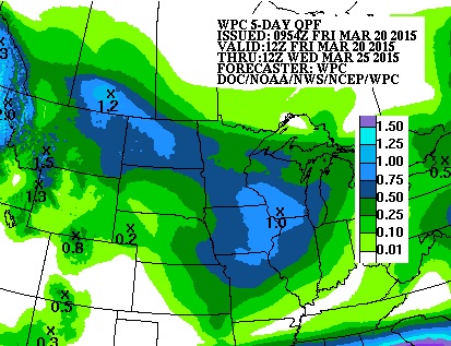
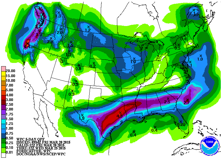
5 Day Precipitation Outlook
Interestingly, according to NOAA's HPC, the 5 day precipitation outlook shows nearly 0.50" to 1.0" through AM Wednesday across parts of the Midwest. This is good news considering the latest U.S. Drought Monitor had nearly 90% of Minnesota under a MODERATE DROUGHT.
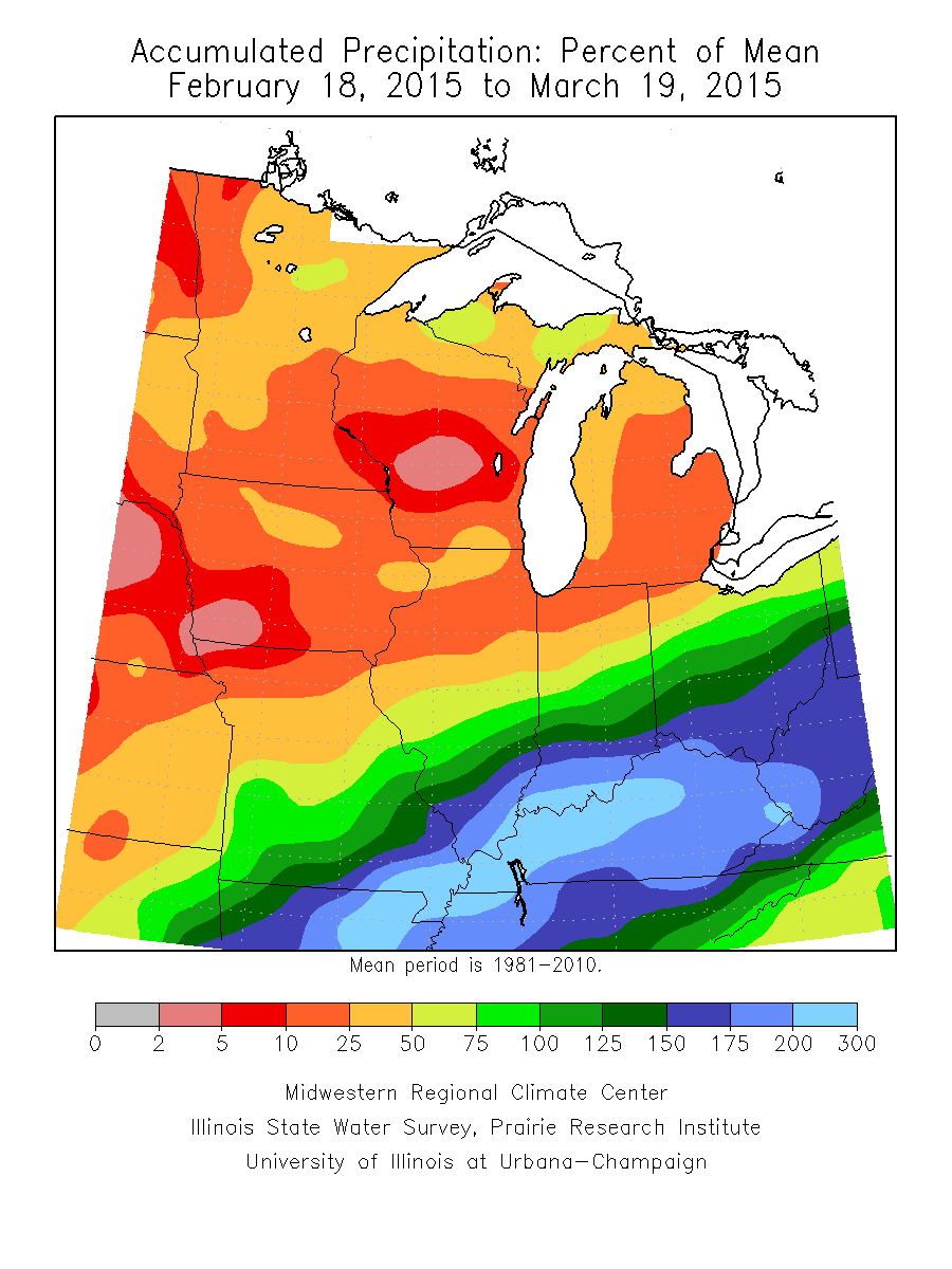
Dry in The Upper Midwest
This is what the percent of mean precipitation over past 30 days looks like across the Midwest. Note that much of the area in orange/red 2% to 50% of mean, while areas across the Ohio Valley are nearly 200% to 300% of mean.
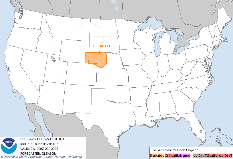
Elevated Severe Threat Saturday
Due to warm, dry and breezy weather conditions, fire weather concerns are elevated on Saturday across much of western Nebraska and far southeastern Wyoming. Unfortunately, with the lack of moisture, fire concerns will be a common theme in these areas over the coming days/weeks until we see the spring green up.
...WRN NEB... VERY WARM DAYTIME TEMPERATURES IN THE 70S F ARE EXPECTED ACROSS THE CNTRL HIGH PLAINS...WITH DEEP BOUNDARY-LAYER MIXING WITHIN A DRY ANTECEDENT AIR MASS YIELDING RH VALUES OF 10-15 PERCENT. A MODEST INCREASE IN SFC WINDS WILL OCCUR W OF A LEE SFC TROUGH DEVELOPING FROM CNTRL NEB INTO THE NRN NEB PANHANDLE...INCREASING TO AROUND 15 MPH. THE ABSENCE OF A TIGHT PRESSURE GRADIENT AND STRONGER FLOW ALOFT WILL PRECLUDE STRONGER WIND SPEEDS. HOWEVER...WELL ABOVE-NORMAL TEMPERATURES COUPLED WITH DRY FUELS WILL SUPPORT AN ELEVATED FIRE WEATHER THREAT.
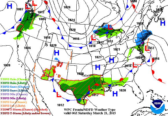
National Weather Outlook
Another round of heavy rain will skirt across Texas and the Gulf Coast States through the early weekend. Keep in mind that areas in the south have had a lot of precipitation over the last couple/few weeks, so any additional heavy rainfall could lead to flooding concerns. Meanwhile, heavy precipitation in the Pacific Northwest will transition of clipper system across the Midwest with a little rain/snow mix.
5 Day Precipitation Outlook
According to NOAA's HPC, the 5 day precipitation outlook suggests nearly 2" to 4"+ across parts of central/eastern Texas and the Gulf Coast States through AM Wednesday. Also note the precipitation across the Midwest/High Plains, these are areas that heavy seen a pretty dramatic increase in drought conditions since the beginning of the year and especially since most of the snow melted.
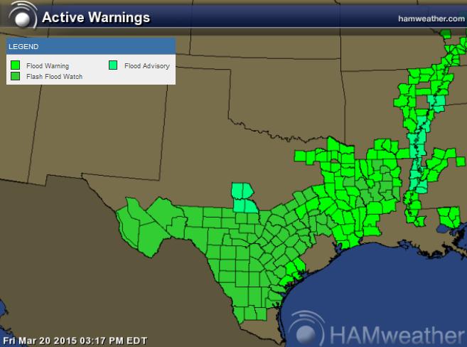
Texas Flood Concerns
Flash Flood Watches have been posted across a much of southern and eastern Texas through PM Saturday.
* WIDESPREAD 2 TO 4 INCHES OF RAINFALL WITH ISOLATED TOTALS OF 6 TO 7 INCHES FROM SLOW MOVING AND TRAINING THUNDERSTORMS.
* RAPID RUNOFF FROM HEAVY RAINFALL WILL LIKELY RESULT IN FLASH FLOODING OF CREEKS AND STREAMS...LOW WATER CROSSINGS...AND URBAN AREAS NORMALLY SUBJECT TO FLOODING. RECENT RAINFALL ALONG AND EAST OF INTERSTATE 35 OVER THE PAST FEW WEEKS HAS LED TO SATURATED SOILS WHICH MAY CAUSE FLASH FLOODING TO OCCUR WITH LESS RAINFALL THAN USUAL...POSING AN ELEVATED THREAT TO LIFE AND PROPERTY.
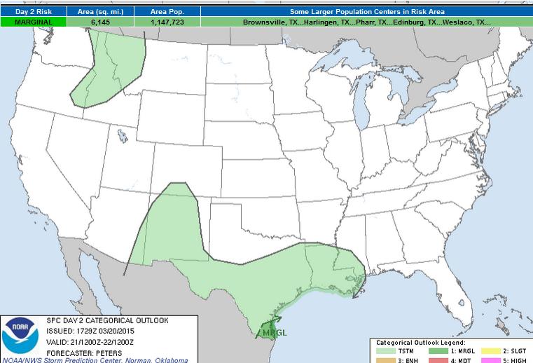
Severe Threat Saturday
It certainly has been an interesting year with regards to severe weather. The lack of severe weather so far through the middle of March is quite staggering! We've actually had so few severe thunderstorm/tornado reports that Greg Carbon, the Warning Coordination Meteorologist from the Storm Prediction Center said that "We are in uncharted territory with respect to the lack of severe weather." The severe weather threat on Saturday will be primarily limited to the southern tip of Texas.
...SOUTH TX... WEAK MIDLEVEL HEIGHT FALLS WILL SPREAD ACROSS NRN MEXICO INTO SOUTH TX AS THE BAJA/NWRN MEXICO UPPER TROUGH EJECTS AND DE-AMPLIFIES. IN RESPONSE TO THIS FEATURE...SLY LOW-LEVEL FLOW WILL BE MAINTAINED ACROSS DEEP SOUTH TX WITH PRECIPITABLE WATER EXCEEDING 1.5 INCHES AND SURFACE DEWPOINTS REMAINING AROUND 70 F. ALTHOUGH LAPSE RATES SHOULD BE WEAK...THE FAVORABLE MOISTURE SHOULD AID IN BOOSTING MUCAPE UP TO 1000 J/KG. THE STRENGTHENING FLOW ALOFT WILL SUPPORT AN INCREASE IN EFFECTIVE BULK SHEAR TO 40-50 KT SUPPORTING A POTENTIAL FOR ORGANIZED STORMS INCLUDING ISOLATED SUPERCELLS...WITH A FEW STORMS BECOMING STRONG TO MARGINALLY SEVERE. GUSTY WINDS AND MARGINALLY SEVERE HAIL ARE THE PRIMARY CONCERNS.
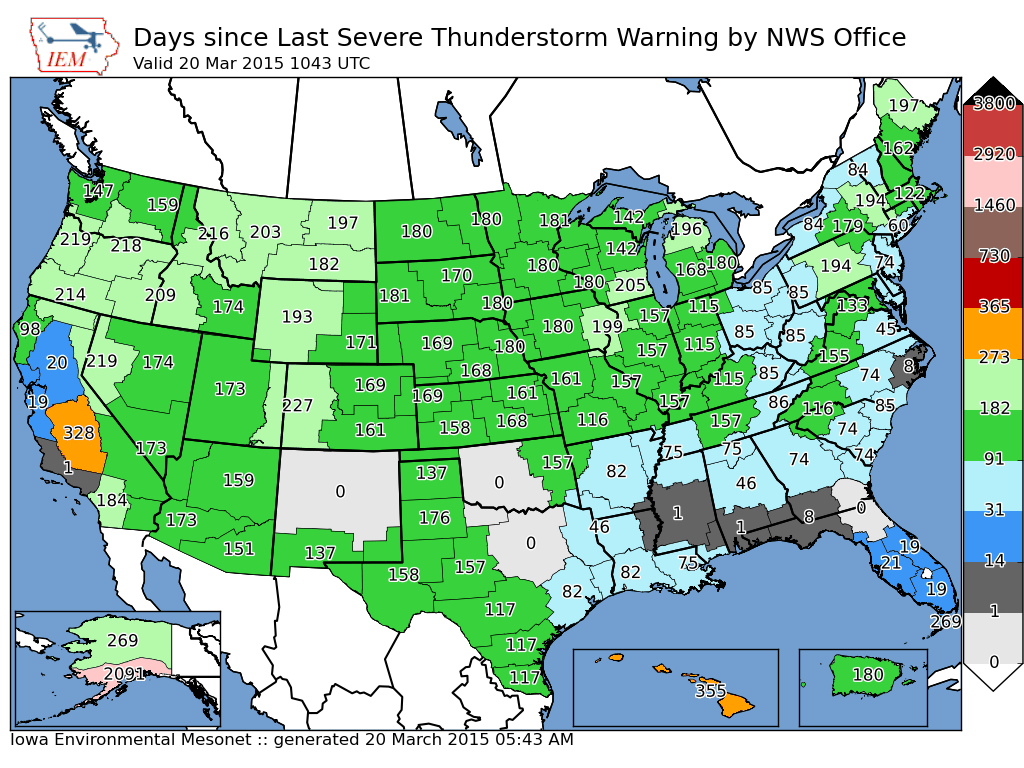
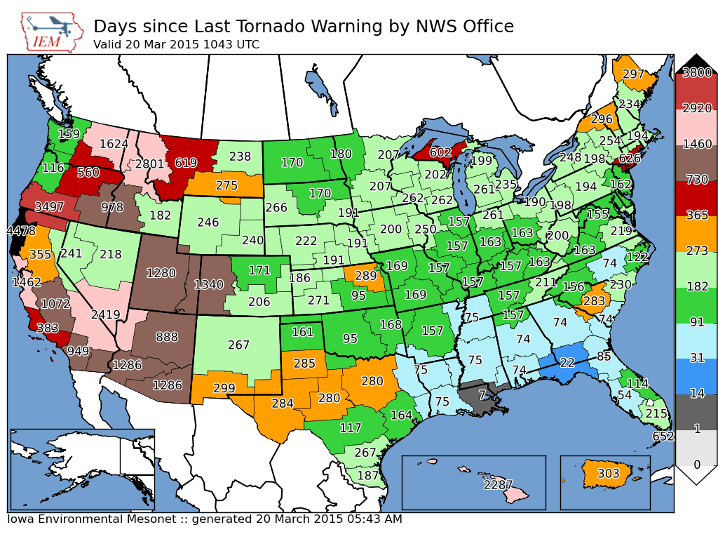
Lack of Severe Weather
Take a look at the images below from IEM (Iowa Environmental Mesonet). The numbers below suggests how many days it's been since particular National Weather Service offices have issued Severe Thunderstorm Warnings and Tornado Warnings. Interesting to note that in the second image below (Days since Last Tornado Warning by NWS Office) there have been quite a few days since last tornado warnings in Texas, while the annual average number of tornadoes in Texas is 11!
A good friend and colleague of mine, DJ Kayser, wrote a nice blog about how significantly low the severe weather threat has been this year/season... check it out HERE:
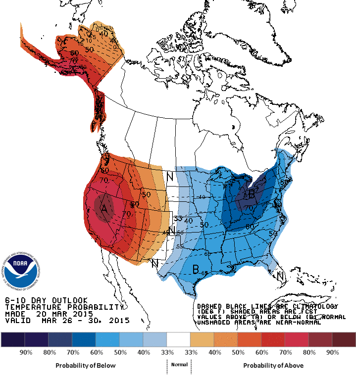
Extended Temperature Outlook
In the 6 to 10 day temperature outlook below. Temperatures look to be very similar to what we've been dealing with for much of the last several months. This persistent patter keeps temperatures in the eastern half of the country cooler than normal, while the weather half of the country and Alaska stays warmer than average. This is a pattern that typically doesn't promote any major severe weather outbreaks. So with that said, look for the lack of severe weather to continue across the country through much of the rest of the month.
"Weather in a Box" ??
Here's an interesting idea that is supposed to mimic that of what the weather may be outside. This "Weather in a Box" machine connects to the internet and grabs forecast data for a selected city and shows you what the weather will be like; rain, clouds, thunderstorm... pretty neat!
See more from Tempescope.com HERE:

Thanks for checking in and have a great weekend ahead! Don't forget to follow me on Twitter @TNelsonWX

No comments:
Post a Comment