Somewhat Snowy Sunday on Tap
Heads up central and southeastern Minnesota! Sunday will be somewhat snowy as a clipper dives through the region. A thin narrow band of sloppy snow accumulations is expected along/south of the I-94 corridor. Enough to potentially shovel and plow in spots through PM Sunday.
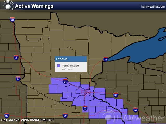
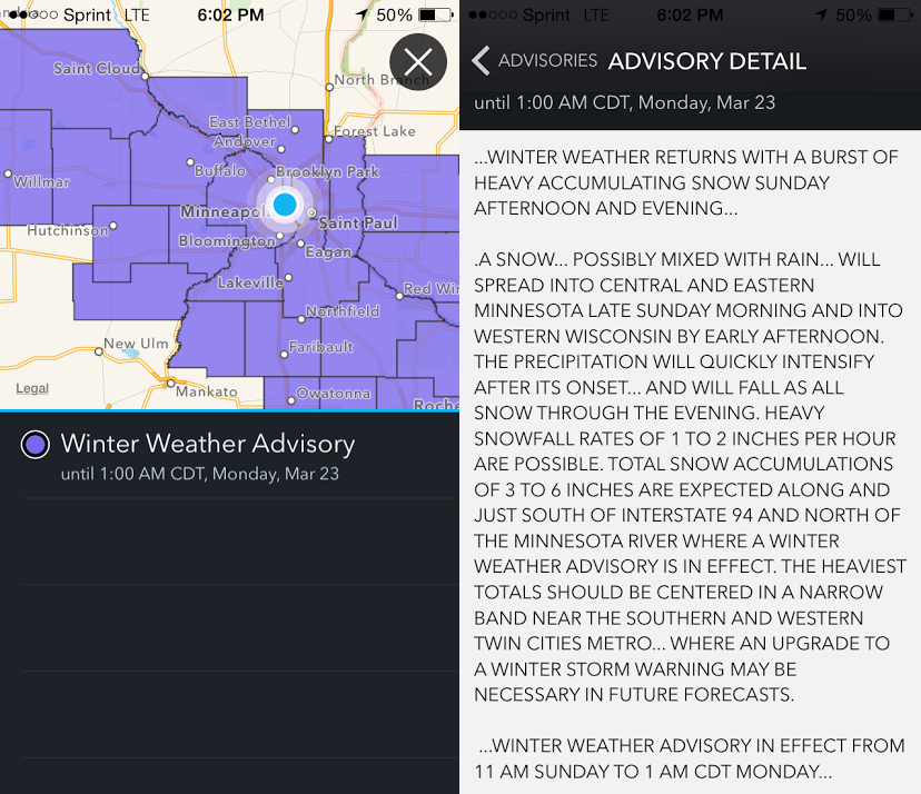
...WINTER WEATHER ADVISORY IN EFFECT FROM 11 AM SUNDAY TO 1 AM CDT MONDAY...
THE NATIONAL WEATHER SERVICE IN TWIN CITIES/CHANHASSEN HAS ISSUED A WINTER WEATHER ADVISORY FOR SNOW...WHICH IS IN EFFECT FROM 11 AM SUNDAY TO 1 AM CDT MONDAY.
* TIMING: A MIX OF RAIN AND SNOW WILL QUICKLY BECOME MODERATE TO HEAVY SNOW BY SUNDAY AFTERNOON. THE SNOW WILL TAPER OFF BY MID SUNDAY EVENING.
* SNOWFALL ACCUMULATIONS: 3 TO 6 INCHES. LOCALIZED TOTALS EXCEEDING 6 INCHES ARE POSSIBLE.
* IMPACTS: TRAVEL MAY BE DIFFICULT SUNDAY AFTERNOON AND EVENING.
...WINTER WEATHER RETURNS WITH A BURST OF HEAVY ACCUMULATING SNOW SUNDAY AFTERNOON AND EVENING...
SNOW...POSSIBLY MIXED WITH RAIN...WILL SPREAD INTO CENTRAL AND EASTERN MINNESOTA LATE SUNDAY MORNING AND INTO WESTERN WISCONSIN BY EARLY AFTERNOON. THE PRECIPITATION WILL QUICKLY INTENSIFY AFTER ITS ONSET...AND WILL FALL AS ALL SNOW THROUGH THE EVENING. HEAVY SNOWFALL RATES OF 1 TO 2 INCHES PER HOUR ARE POSSIBLE. TOTAL SNOW ACCUMULATIONS OF 3 TO 6 INCHES ARE EXPECTED ALONG AND JUST SOUTH OF INTERSTATE 94 AND NORTH OF THE MINNESOTA RIVER WHERE A WINTER WEATHER ADVISORY IS IN EFFECT. THE HEAVIEST TOTALS SHOULD BE CENTERED IN A NARROW BAND NEAR THE SOUTHERN AND WESTERN TWIN CITIES METRO...WHERE AN UPGRADE TO A WINTER STORM WARNING MAY BE NECESSARY IN FUTURE FORECASTS.
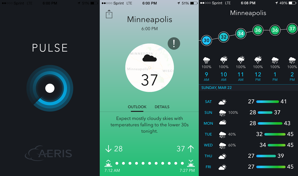
Aeris Pulse
Here's a nice new app for your smartphone called Pulse. I FINALLY had a chance to check it for our location. Of course, we haven't had much weather to talk about here locally, so it's finally getting a nice debut in the Minneapolis region now.
Sunday Slop Potential
By Todd Nelson
By Todd Nelson
I've been a Minnesotan my entire life and from a young age, I can remember most years getting hit by a big slop storm during tourney time. Statistically, March is Minneapolis' 3rd snowiest month of the year, averaging a little more than 10". Of course this year, we've been off to a VERY quiet start; running nearly 6" below average prior to today. Now as I turn my attention from my busted NCAA bracket to the weather maps, I am noticing quite a bit of activity close to home over the next several days.
Our first sloppy system pushes through today with a thin band of up to 1" to 3" snow along/south of the I-94 corridor. The next system on Tuesday/Wednesday looks a little more substantial with the potential of heavier accumulations across a much larger area!
Keep in mind that these systems will have a much higher water content to any snow accumulations, so any potential shoveling will be a bear! The good news is that this moisture will help dampen fire concerns a bit! Also, warmer temps and a higher sun angle generally makes quick work of any snow that accumulates.
Yes, this is more typical March weather in Minnesota... After all it is still tourney time.
====================
SATURDAY NIGHT: Mostly cloudy. Low: 27. Winds: NE 5-10
SUNDAY: Rain/snow mix developing. High: 39. Winds: E 5-15
SUNDAY NIGHT: Snow tapers. Total accumulations along/south of the I-94 corridor up to 2" to 4" possible with isolated higher amount in a very thin, narrow band SSE of the Twin Cities. Low: 28. Winds: E 5-10.
MONDAY: Mix of clouds and sun. High: 44. Winds: SE 5-10
TUESDAY: Breezy. PM rain/snow mix. Wake-up: 29. High: 46
WEDNESDAY: Windy. Rain changes to snow. Wake-up: 34. High: 44
THURSDAY: Less wind. Lingering clouds and flakes. Wake-up: 28. High: 39
FRIDAY: Partly sunny, near average temps. Wake-up: 24. High: 42.
SATURDAY: Breezy south wind. Rain late. Wake-up: 30. High: 48.
==================
This Day in Weather History
March 22nd
March 22nd
1991: Ice storm began during the afternoon and ended as the event changed to heavy, wet snow on the 23rd. This event coated the city of Duluth with as much as 6 inches of ice. The 850-foot WIDO TV tower was toppled. 4 million pine trees were damaged or destroyed with the heaviest damage at G.C. Andrews State Forest near Moose Lake in Pine County.
1952: Snowstorm dumps 13.2 inches on the Twin Cities.
=================
Average High/Low for Minneapolis
March 22nd
March 22nd
Average High: 44F (Record: 71F set in 1945)
Average Low: 27F (Record: -14F set in 1888)
Average Low: 27F (Record: -14F set in 1888)
=================
Sunrise/Sunset Times for Minneapolis
March 22nd
March 22nd
Sunrise: 7:13am
Sunset: 7:28pm
Sunset: 7:28pm
==================
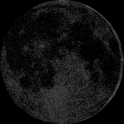
Moon Phase for March 22nd at Midnight
2.9 Days After New Moon
2.9 Days After New Moon
====================
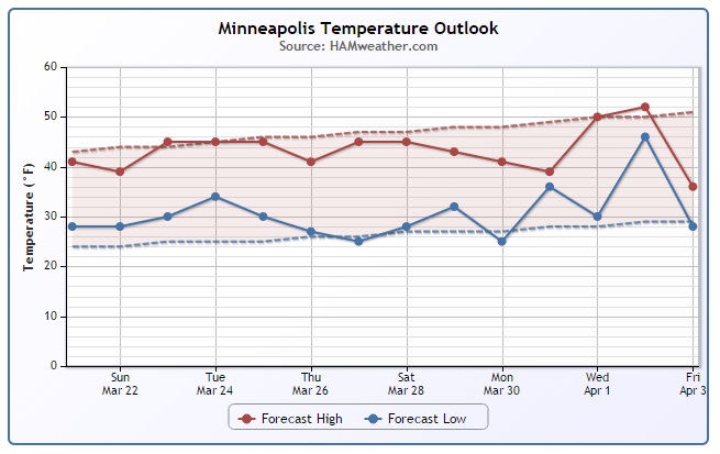
Minneapolis Temperature Trend
Here's the forecast for Minneapolis through the end of the month/early April. Note that temperatures look to stay pretty close to if not a little below average in the high temperature department. While temperatures are a much cooler than what we were dealing with last weekend, this what March should be like. Also note that March is the 3rd snowiest month for Minneapolis, average a little more than 10" of snow. As of Saturday, we were nearly 6" below average, so with the upcoming snow potential Sunday and next week, we should be able to chip away at the current snowfall deficit.
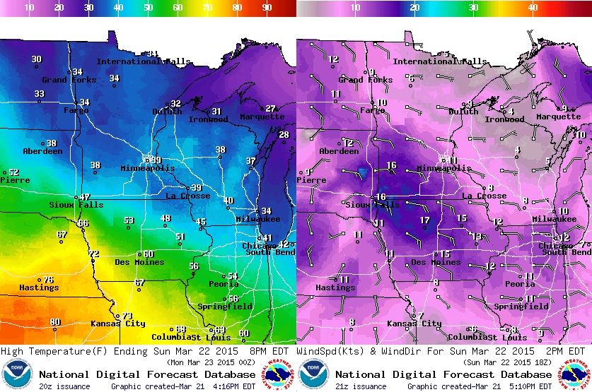
Sunday Weather Outlook
High temperatures on Sunday will be in the 30s across the state with an easterly wind around 5-15mph. Due to temperatures being snow 'warm' during the snow event, snow conditions are expected to be very wet and sloppy. It'll be the heavy kind if you happen to have any shoveling duties....
Sunday Weather Outlook
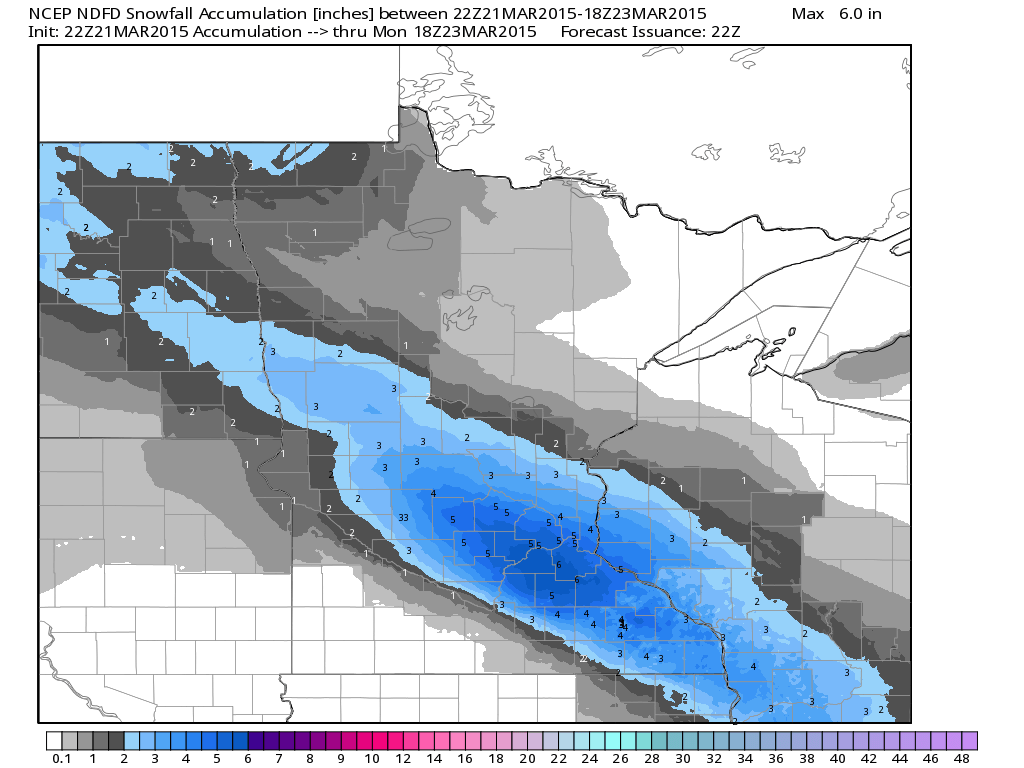
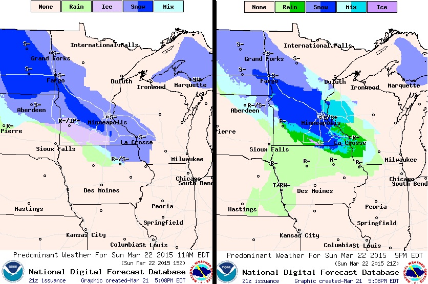
The images below show the precipitation potential from 11am Sunday (left) to 5pm Sunday (right). Snowfall could be fairly heavy at times Sunday, which may impact travel by the afternoon/evening.
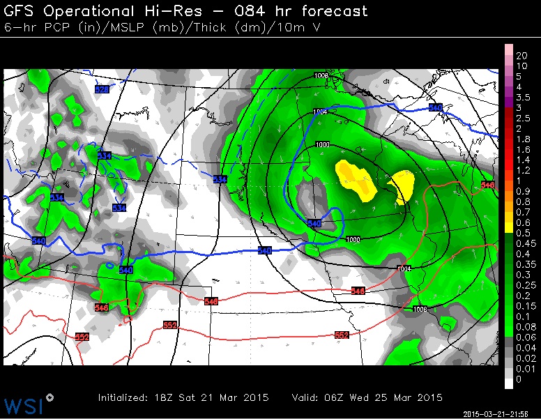
Another Sloppy System Midweek?
Active weather continues throught the week ahead with another sloppy system moving through the Region PM Tuesday/Wednesday. Temperatures look to start off warm enough for a little rain, but as temperatures cool overnight Tuesday/Wednesday, snow looks to mix in with potentially some addtional accumulations. Stay tuned for more!
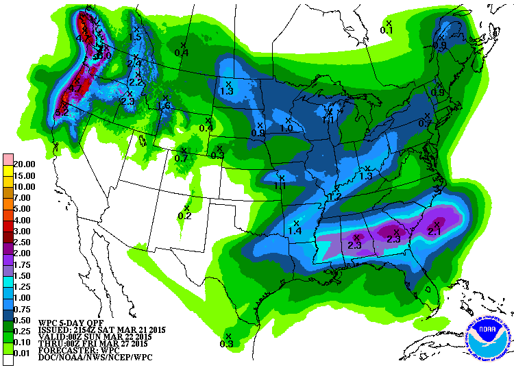
Midwest: 5 Day Precipitation Outlook
Hey, hey... looky here! While it certainly has been quite dry over the past several weeks, we may be in for a little more substantial/benefial precipitation through PM Thursday. According to NOAA's HPC, the 5 day precipitatoin forecast suggests nearly 0.50" to 1.00" liquid possible across parts of the Upper Midwest. This will certainly help to dampen the fire concerns that have been ramped up recently due to the lack of moisture and snow cover.

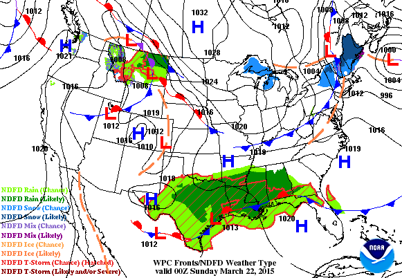
National Weather Outlook
When you think Spring, you tend to think more active weather as the atmosphere transitions from winter to summer. Take a look at how active it appears through early next week. Heavy rain/thunderstorms across the Gulf Coast States and another developing storm in the Pacific Northwest moving into the Midwest by midweek.
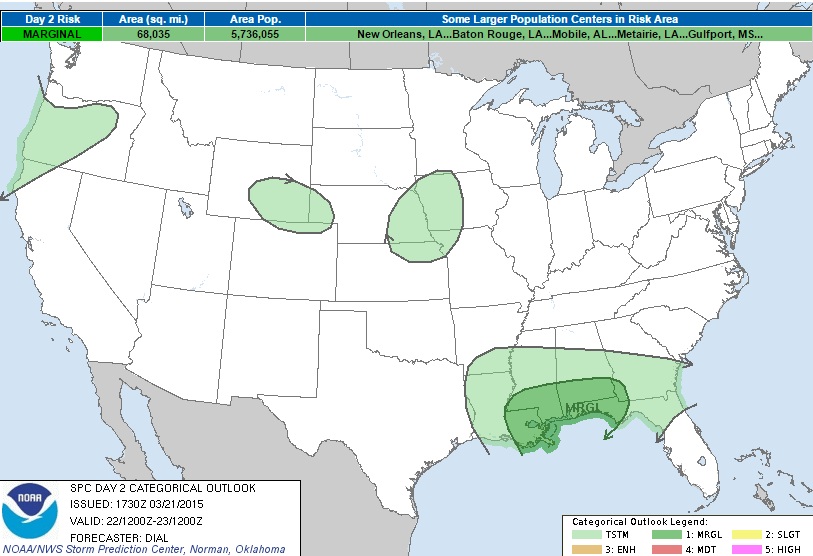
Severe Sunday?
NOAA's SPC has a MARGINAL severe threat across parts of the Gulf Coast States by PM Sunday
WIND PROFILES WILL STRENGTHEN IN ASSOCIATION WITH A MID-LEVEL JET ATTENDING THE UPPER TROUGH WITH LARGELY UNIDIRECTIONAL EFFECTIVE BULK SHEAR FROM 40-50 KT. SFC-BASED THUNDERSTORMS ARE EXPECTED TO DEVELOP ALONG AND SOUTH OF WARM FRONT AND ALONG A SEWD ADVANCING COLD FRONT. A POTENTIAL LIMITING FACTOR FOR A MORE ROBUST SEVERE EVENT WILL BE THE EXPECTED MARGINAL THERMODYNAMIC ENVIRONMENT. NEVERTHELESS...SUFFICIENT CAPE MIGHT DEVELOP TO SUPPORT A FEW ROTATING UPDRAFTS AND BOWING SEGMENTS CAPABLE OF PRODUCING ISOLATED HAIL AND STRONG WIND GUSTS. WILL MAINTAIN 5% SEVERE PROBABILITIES FOR NOW...BUT AN UPGRADE TO SLIGHT RISK MIGHT BE WARRANTED IF IT BEGINS TO APPEAR INSTABILITY WILL BE GREATER THAN CURRENTLY ANTICIPATED.
National: 5 Day Precipitation Outlook
Heavy rain and potential flooding continues to churn along the Gulf Coast States into the early week timeframe while conditions along the nothern tier of the nation remain active. Note that the heaviest precipitation will be in the Southeastern U.S. and Northwestern U.S., but it sure is nice to see a littel more substantial stuff in the Midwest where drought conditions have popped up due to several weeks of dry weather. Unfortunately, it appears that another round of heavier precipitation/thunderstorms could impact folks in the Ohio Valley by midweek. These are areas that have been dealing with flooding over the past couple of weeks thanks to a VERY wet month thus far.
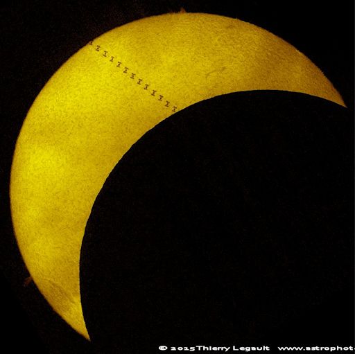
More on Friday's Total Solar Eclipse
Oh man, this is cool! A solar eclipse on Friday caught the attention of many, but one particular photo stands out as not only was the solar eclipse visible, but the ISS was captured at the same time as well!!
"What are the odds? March 20th, just as the Moon was passing in front of the Sun, producing a deep solar eclipse over Europe, the International Space Station flew directly through the eclipse zone. Thierry Legault photographed the split-second transit from Fregenal de la Sierra, Spain:"I had to drive a lot to find clear skies," says Legault, "but I managed to catch the ISS during the eclipse. The duration of the visible part of the transit was only 0.6s.""
(Image courtesy: Spaceweather.com via Theirry Legault)
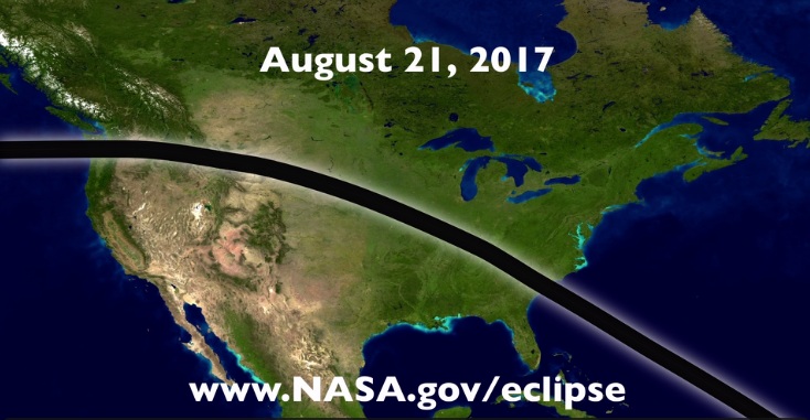
Next Big Solar Eclipse in 2017?
Well, if you missed the eclipse last Friday... you might have a chance to see one in your backyard in about 2 years! Here's a preview of the Solar Eclipse in 2017 from the U.S.!
"People living in America will have a chance to see a total eclipse travel across the U.S. from Oregon to South Carolina on August 21, 2017. Residents in parts of Illinois and Kentucky will have the full experience of over two minutes of a completely darkened sun."
Bad Spring Allergy Season Ahead?
For those of you who suffer seasonal (Spring) allergies... you may want to listen up:
"Allergy Season 2015: Experts Predict Severe Allergy Symptoms, But A Shorter Season
Dr. John Basso, chief of allergy and immunology at Nyack Hospital in New York, told USA Today “the prolonged moisture in some regions this winter may have laid the groundwork for a bad season.” Basso explained a warm, dry spring following a wet winter is a recipe for high pollen counts. But if we were to have a wet spring, pollen might not be such a problem.
Pollen levels over the past few years have been unusually elevated, the overall season starting earlier and lasting longer. This year, Dr. Tanya Laidlaw, director of Translational Research in Allergy at Brigham and Women’s Hospital in Boston, told Tech Times the classic oak, birch, and maple trees will be late to pollinate — so there’s a chance seasonal allergies will be cut short by at least a few days."
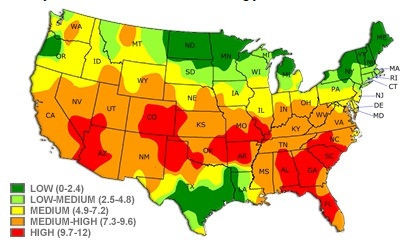
Pollen Forecast
Here's a good bookmark for you if you're looking for a pollen forecast. Note how high the spring pollen levels are already across the central and southern tier of the nation where spring has sprung!
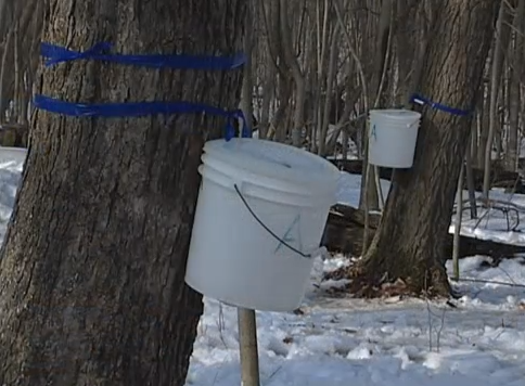
Maple Syruping?
Tis the season for maple syruping in a maple tree near you! Thanks to the MN DNR, you can attend a maple syruping event while the sap runs continue. In fact, Fort Snelling will be holding an event this Sunday...
Maple Syruping in Your Backyard
Date: 03/22/2015
Time: 1 PM to 2:30 PM
Location: Fort Snelling State Park
Description: Join us for our annual "Maple Syruping in Your Backyard" workshop. Learn about the natural history of maple trees and the history of making maple syrup. Find out what equipment is required, how to tap trees, how to process sap into syrup, and the best part- tasting the syrup!
Directions: Take the Post Road exit off Highway 5 and follow the signs.
More Information: Call (612) 279-3550 or Visitor Center (612) 725-2724.
Signs of Spring...
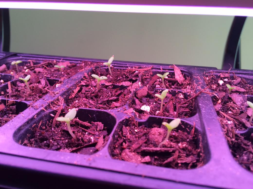
Hello to all my fellow gardeners out there, I hope you're enjoying all your new little friends. I am fairly new to the starting from seed method, but I am upping my game this year with a grow light! I have found that over the past couple of years, my plants have become a little leggy in my cheap little greenhouse sitting by the window. I figured I'd give the grow light a shot this year and see how it turns out. Of course, for us in zone 4, it may be just a little early to start your veggies, but you can get to some of those flowers... Pansy's/Geranium/Viola and a few others. Let me know how your growing adventures are going and what works the best. I've been finding a lot of useful information on youtube!!
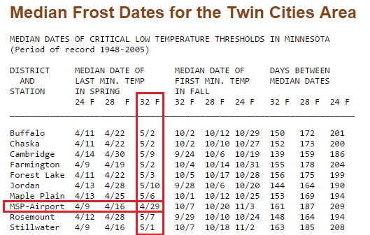
Average Last Frost Date
Of course, if you're getting serious about starting seeds... you might find that knowing your average last Spring Frost Date is helpful! According to the State Climatology Office, Minneapolis' average last frost date is April 29th, but several other locations around the Twin Cities area see their average last frost date within the first week of May. Happy growing!
Thanks for checking in and have a great rest of your weekend/week ahead! Don't forget to follow me on Twitter @TNelsonWX

No comments:
Post a Comment