62 F. high in the Twin Cities yesterday.
41 F. average high on March 16.
25 F. high on March 16, 2014.
March 17, 1965: Great St. Patrick's Day Blizzard. Two feet of snow dumped at Duluth. 19 inches at Mora.
Feeling Lucky?
It was a winter devoid of major, knock-down, drag-out blockbuster snowstorms but we saw our fair share of annoying clippers. At temperatures colder than 15F a meager inch of snow, at the wrong time, sparks gridlock and a disproportionate number of fender-benders. But 27 inches of snow? Kentucky picked up more snow than the Twin Cities as a temporarily locked jet stream pattern whisked the most formidable storms well south of Minnesota.
J. Meilinger wanted to know if MSP set any cold weather records. No. We counted up 3 records for the metro: the warmest low on December 14 (43F), a record high on December 15 (51), and a snowfall record for January 8 (3 inches).
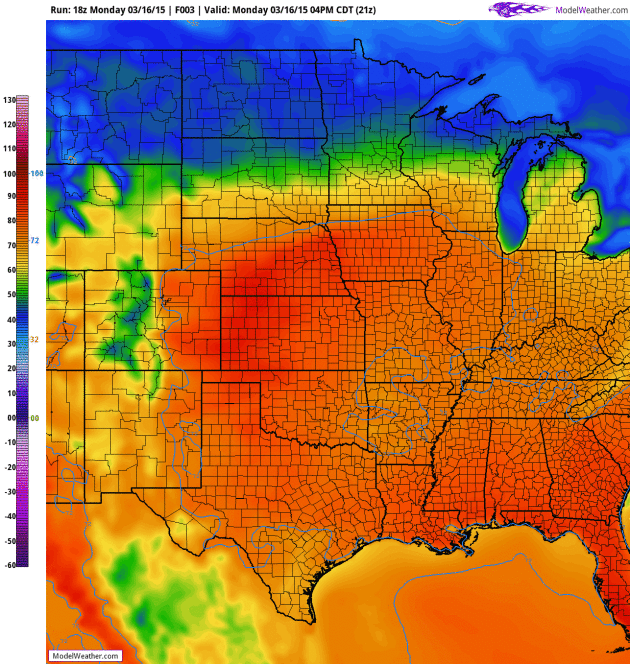
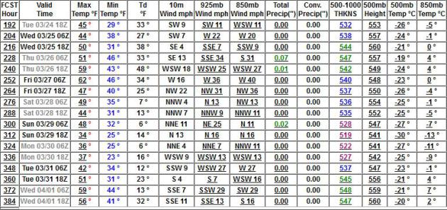
I don't see any big slush storms, just a temperature correct with 40s this week, 30s possible by the weekend. It'll be cold enough for snow but prevailing winds keep us dry, with few exceptions. The same old song and dance. Expect a chilly bias, maybe a few flakes or snow showers the next 2 weeks, but nothing Boston-like.
108.6 inches has fallen in Boston, a new all-time record. Mayor Marty Walsh tweeted: "Superbowls, World Series, Stanley Cups and snowfall records. We are truly a title city. There will be no parade."
Go big or go home, right?

Boston Sets New Snow Record. And here we sit in the Twin Cities at a whopping 27.2" for the winter, to date. Here's an excerpt from NBC News: "Boston
officially broke its snowfall record for one season, notching up 108.6
inches this winter, the National Weather Service said Sunday. February
was by the snowiest February on record in Boston, at 64.8. For the
winter season, that put the city an inch above the 107.6 inches set in
the winter of 1995-96..."
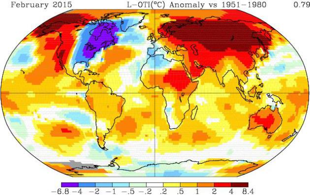
NASA: February 2015 Was Second Warmest After 1998. The site, reportingclimatescience.com, has an update; here's an excerpt: "...Significantly
warmer than usual weather in parts of the northern hemisphere pushed up
global average temperatures last month, according to data released by
US space agency NASA. The global average surface temperature in February
2015 was +0.79oC above the long term average, according to NASA. This was 0.04oC warmer than the January and makes the month the second warmest February – behind 1998 (+0.86oC) - on the records maintained by the agency which date back to 1880..."
Image credit above: "NASA
GISS global surface temperature anomaly map for February 2015 showing
particularly high anomalies across northern Europe, Eurasia, China and
the Arctic. Note: Gray areas signify missing data. Note: Ocean data are
not used over land nor within 100km of a reporting land station." Courtesy: NASA.
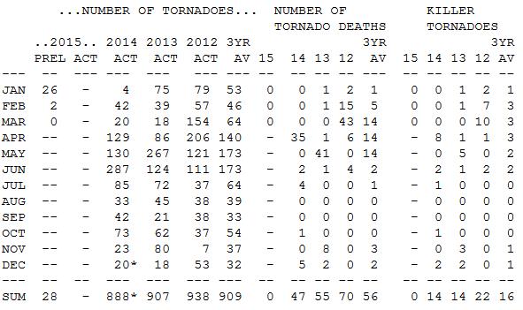
Weather Weirdness? Often-Deadly March Has Seen Zero Tornado Reports So Far. The Washington Post's Capital Weather Gang takes a look at a remarkably quiet March, to date. Here's an excerpt: "...Not
a single tornado has been reported to the National Weather Service so
far in March, which typically marks the first month of severe
weather season in the Plains and Southeast. According to the Weather
Channel’s severe expert Greg Forbes, the only other year since 1950 that
there have been zero tornado reports in the first half of March was
1969..." (Data above courtesy of NOAA SPC).
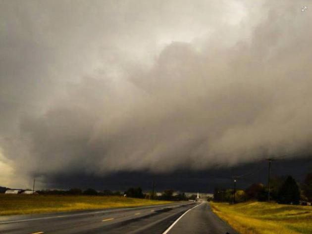
El Nino Can Predict Tornado Season's Severity. Another quiet tornado year? It's a little premature to wave that flag, but here's an excerpt of a story at Live Science: "This
year's El Niño may not only bring a bit of drought relief to parched
Western states, but also could deliver a quiet tornado season, a new
study finds. Much of the southeastern United States faces a lower risk
of tornadoes during El Niño years, the new research shows. The effects are strongest in Oklahoma, Arkansas and northern Texas..." (Photo credit above: Nashville National Weather Service).
* USA TODAY has another perspective on El Nino and 2015's tornado risk here.
"Twin" Cyclones Could Jolt Weak El Nino. Climate Central
ran this article on Friday, and I wanted to make sure I posted this,
showing the potential interplay between tropical cyclones and El Nino:
"...Where the two cyclones come in is the winds associated with
an El Niño. Normally, the tropical Pacific features a pool of warm water
in the west and cooler temperatures to the east, where cold waters well
up from deep off the coast of South America. The prevailing easterly
trade winds keep this temperature pattern in place. When an El Niño
occurs, the winds slacken and can even reverse to blow from the west.
That sends the warm waters spilling eastward, the hallmark of an El
Niño. (When a La Niña occurs, the easterlies grow stronger and intensify
the east-west temperature contrast.)..."
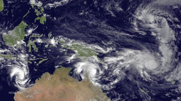
Image credit from March 13 above: "Cyclone
Pam (bottom right) and Tropical Depression 3, or Bavi (top right), are
two of four cyclones spinning in the oceans around Australia." Credit: NOAA.

Flexible Cloth Harnesses Human Motion To Generate Electricity. Gizmag has an eye-opening post; here's an excerpt: "We've already heard about how thermoelectric or piezoelectric
clothing could be used to generate electricity for our mobile devices.
Now, an international team of scientists has successfully used special
fabric to serve as an electricity-generating triboelectric
nanogenerator. The research could pave the way for clothing that charges
devices simply by moving..."
File image above: "In the future, simply running while wearing your favorite hoodie could be sufficient to charge gadgets carried within it." (Photo: Shutterstock).
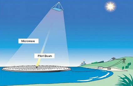
Japan Takes a Step Towards Beaming Solar Power to Earth from Space. It's amazing how quickly science fiction can morph into reality. Here's another clip from a story at gizmag.com: "A
successful ground test of a system designed to ultimately collect solar
power from orbit and beam it back down to Earth was announced in Japan
this week by Mitsubishi Heavy Industries. The wireless power
demonstration saw 10 kilowatts sent over microwaves from a transmitting
unit to a receiver 500 meters (1,640 ft) away..."

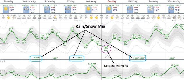
TODAY: Bright sun, seasonably cool. Winds: NW 15. High: 45
TUESDAY NIGHT: Mostly clear and brisk. Low: 30
WEDNESDAY: Clouds increase, light mix late? High: 43
THURSDAY: Gray, cool and damp. Wake-up: 31. High: 44
FRIDAY: Another clipper. Late slushy mix? Wake-up: 29. High: 45
SATURDAY: Partly sunny, turning colder. Wake-up: 27. High: 35
SUNDAY: Blue sky, light winds. Still chilly. Wake-up: 21. High: 37
MONDAY: Unsettled, rain/snow showers. Wake-up: 27. High: near 40
Climate Stories...
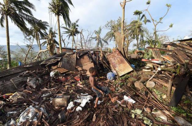
Photo credit above: "Samuel, only his first name given, kicks a ball through the ruins of their family home as his father, Phillip, at back, picks through the debris in Port Vila, Vanuatu in the aftermath of Cyclone Pam Monday, March 16, 2015. Vanuatu's President Baldwin Lonsdale said Monday that the cyclone that hammered the tiny South Pacific archipelago over the weekend was a "monster" that has destroyed or damaged 90 percent of the buildings in the capital and has forced the nation to start anew." (AP Photo/Dave Hunt, Pool)
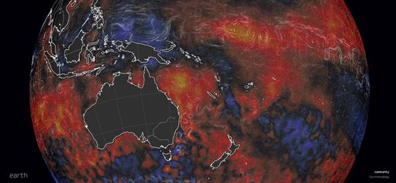
Cyclone Pam: Untangling The Complex Science on Tropical Storms and Climate Change. Here's a clip from an informative and timely story at Carbon Brief: "...Tropical storms derive energy from the warmth of the ocean and convert it into wind strength. While strong storms aren't unusual for the region, Cyclone Pam was exceptional. Prof Kevin Trenberth, expert in climate change and extreme weather at the US National Centre for Atmospheric Research, tells Carbon Brief:
"In the large area around Vanuatu the sea surface temperatures were one
to two degrees Celsius above normal … So the atmosphere all around
there has some 10 to 20% more moisture in it than a comparable storm in
the 1970s would have had..."
Image credit above: "Sea
surface temperature anomaly for 16th March 2015, compared to 1981-2011
daily average. Blue is lower than average, red is higher." Images courtesy of Cameron Beccario via earth.nullschool.net
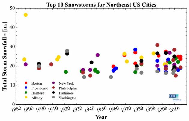
Graphic credit above: "Top 10 snowstorms by snowfall in inches in the historical record for Washington; Baltimore; Philadelphia; New York; Albany, N.Y.; Providence, R.I.; Hartford, Conn.; and Boston." (Judah Cohen/Jason Furtado/AER).

Image credit above: "President Ronald Reagan (right) with George Shultz (left), who served as secretary of state under Reagan from 1982 to 1989." (Courtesy of Hoover Institution).
Photo credit: Kennedy Space Center.


No comments:
Post a Comment