Desert Blooms
You know it's spring in the desert when the cacti are blooming! These incredible looking flowers last for a very short time, so consider yourself lucky to see a full bloom like this! Thanks to my family for sending this picture along over the weekend. Transplants from Minnesota, they now reside in Surprise, AZ and they haven't looked back! I sure am sad that we won't be able to make it out to see the spring beauty this year...

Mea Culpa
By Paul Douglas
Economics has been called "the dismal science" but meteorology could give it a good run for the money. Predicting the future (in public) in a day and age of social media snark is not for the faint of heart.
"Why can I watch 4 TV stations and get 4 different outlooks?" It all comes down to interpretation. Which model do you believe and why? In this country we have the freedom to disagree with the official government (NOAA) forecast.
"Why does the forecast change so much?" New data is constantly streaming in, from airports, weather balloons and satellites. NOAA models generally update 4 times daily. As newer, fresher, more timely data arrives the weather models should, in at least in theory, become more accurate over time.
Welcome to a balmy Monday; 60s before a minor reality check sets in later this week. Expect highs in the 40s from to into much of next week. Still respectable, considering the average high now is 40F, but no more wild episodes of spring fever into late March.
It's been a good week: today is the 6th day above 60F since last Tuesday. A year ago today the high was only 25F in the Twin Cities. Expect cool, generally dry weather the next 2 weeks.
=============
SUNDAY NIGHT: Mostly cloudy. Low: 47. Winds: WSW 5-15.
MONDAY: Mild start, then gusty and cooler with a slight rain chance. High: 63. Winds: N 10-15.
MONDAY NIGHT: Spotty shower early, mostly cloudy. Low: 30. Winds: N 10-15.
TUESDAY: Cool sunshine, winds ease.. High: 45. Winds: NNW 10-15
WEDNESDAY: Clouds increase, showers late. Wake-up: 31. High: 44.
THURSDAY: Mostly cloudy and cool. Wake-up: 29. High: 42.
FRIDAY: Spring Begins! More clouds than sun, milder. Wake-up: 28. High: 50.
SATURDAY: Mostly gray, probably dry. Wake-up: 36. High: 43.
SUNDAY: Slight risk of rain/snow mix. Wake-up: 32. High: 40.
=================
This Day in Weather History
March 16th
1930: The temperature at the Minneapolis-St. Paul International Airport tops out at a record 71 degrees.
=================
Average High/Low for Minneapolis
March 16th
Average High: 41F (Record: 79F set in 2012)
Average Low: 24F (Record: -10F set in 1900)
==================
Sunrise/Sunset Times for Minneapolis
March 16th
Sunrise: 7:23am
Sunset: 7:21pm
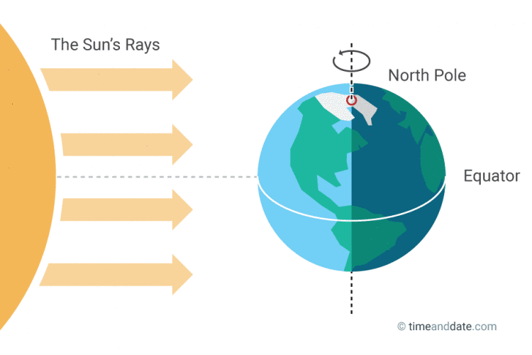
**NOTE** Sunrise/sunset times getting closer to 12hours apart. We are nearing the Vernal Equinox, which occurs this Friday, March 20th at 5:45pm CDT when the sun's most direct rays shine over the Equator.
(Image courtesy: Timeanddate.com)
==================
Moon Phase for March 16th at Midnight
3.1 Days Before New Moon

===================
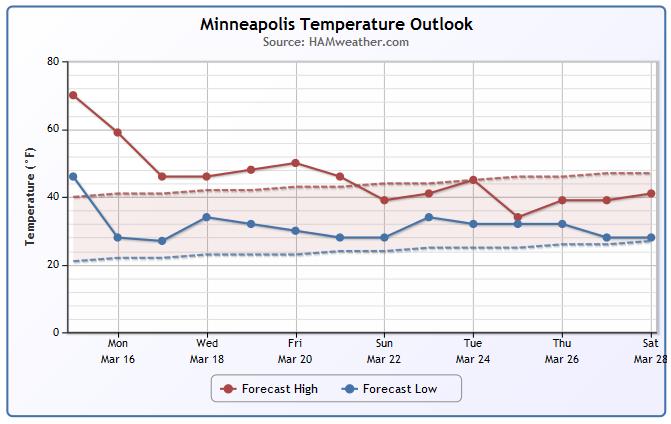
Minneapolis Temperature Trend
After a week of April/May temperatures across the Upper Midwest, we take a bit of a hit through the week ahead. Monday will still be quite warm, but readings will only be slightly above average from Tuesday on. The end of the month looks to end at or slightly below average... Hey, at least we're not going sub-zero!
=====================
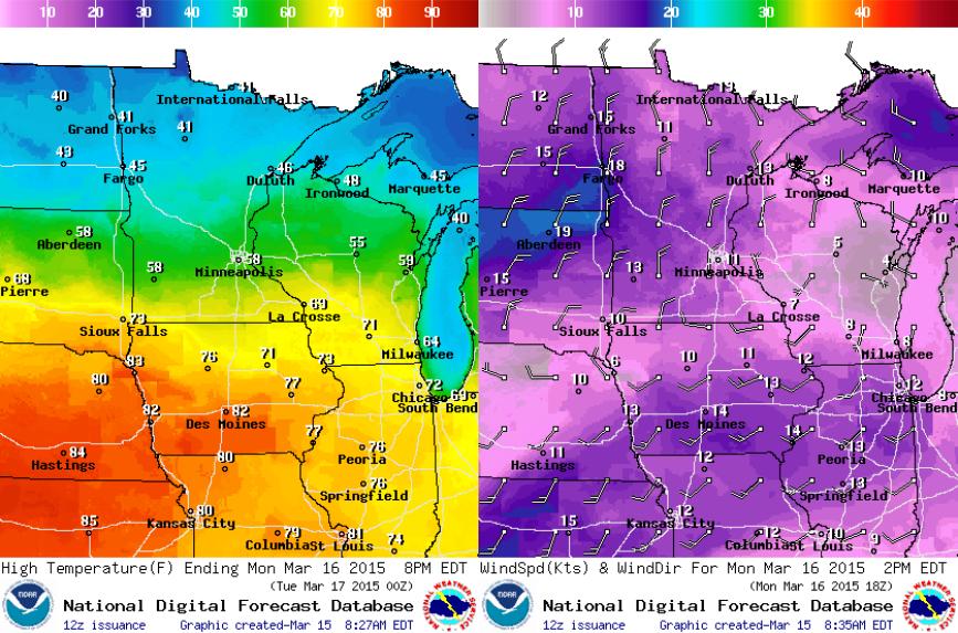
Monday Weather Outlook
The passage of a cold front on Monday will bring slightly cooler temperatures back to the region. Highs will still be in the 70s and 80s ahead of the front through parts of Iowa, but farther north we'll fall back into the 40s with breezy north winds.
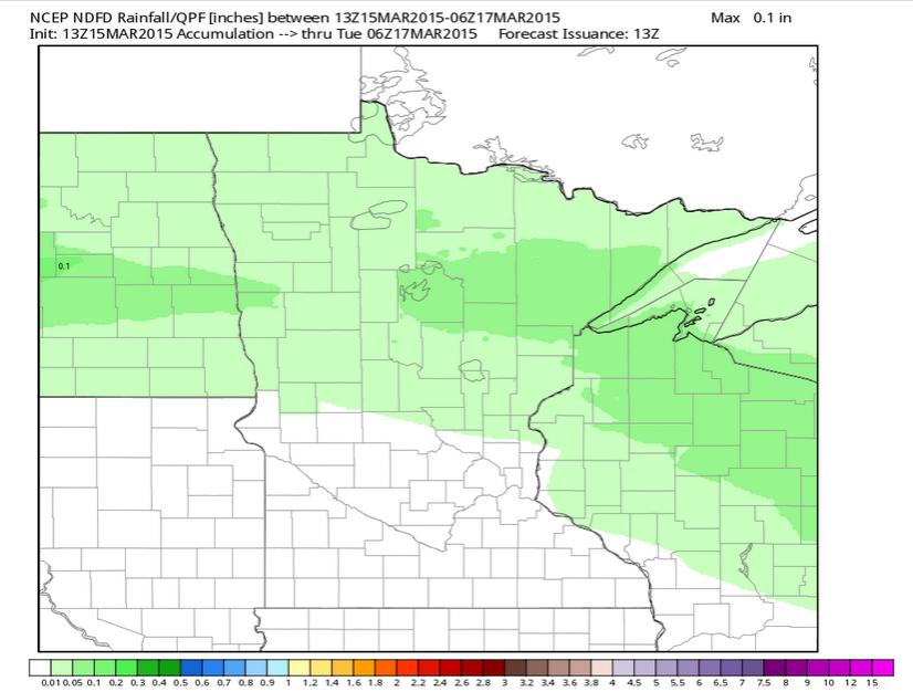
Monday Rainfall Potential
A little light precipitation will be possible on Monday as the front slides through, mainly across the northern part of the state and perhaps up to 0.10" liquid possible.
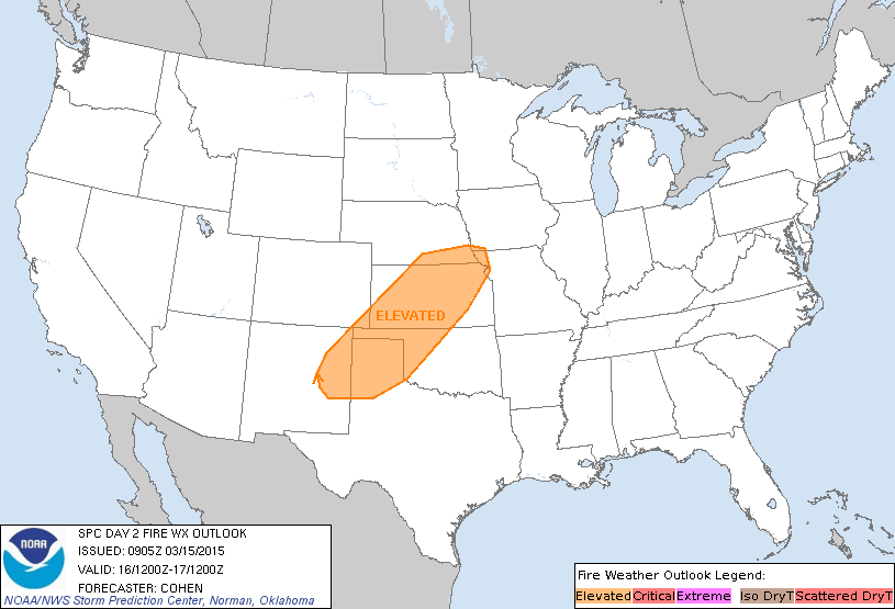
Monday Fire Weather Potential
Flooding Along the Ohio River
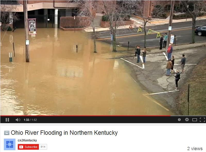
While folks across the Plains and the Midwest are dealing with dry weather and the threat of wildfires, folks across the Ohio and Mississippi River Valley are dealing with flooding. This was the view from Louisville, KY on Saturday as the Ohio River was at MINOR flood stage.
See the video from cn2Kentucky HERE:
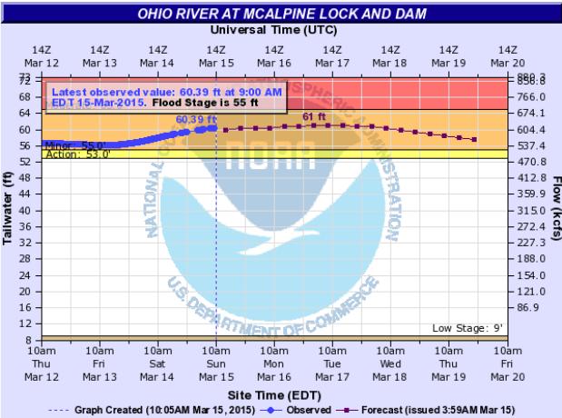
Ohio River in Louisville at MINOR Flood Stage
This was the river gauge along the Ohio River in Louisville on Sunday morning, which showed the river still in MINOR flood stage. It appears that minor flooding will continue through much of the week ahead.
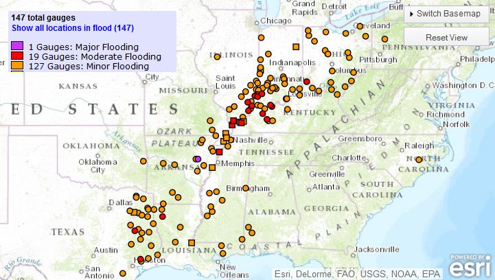
River Flooding Continues
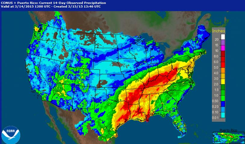
Here is the maximum forecast flood category through March 24th. Note how many rivers are expected to be in minor/moderate/major flood stage through that time! The culprit is heavy precipitation over the past couple of weeks. Some of these locations have seen nearly 2" to 6"+ since the beginning of the month.
Precipitation Past 14 Days
Radar estimated precipitation over the last 14 days suggests nearly 2" to 6"+ from eastern Texas to New York. The heaviest (in red) suggests 5" to 6"+, some of which has occurred in parts of Kentucky. Louisville, KY for example has seen nearly 7" of precipitation through the first 14 days of the month!
National Weather Outlook
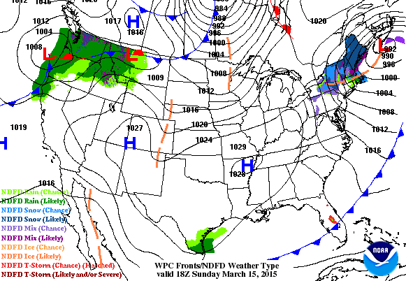
Watch the cool front sweep across the nation through the early week time frame. Moisture will be quite limited across the middle part of the country.
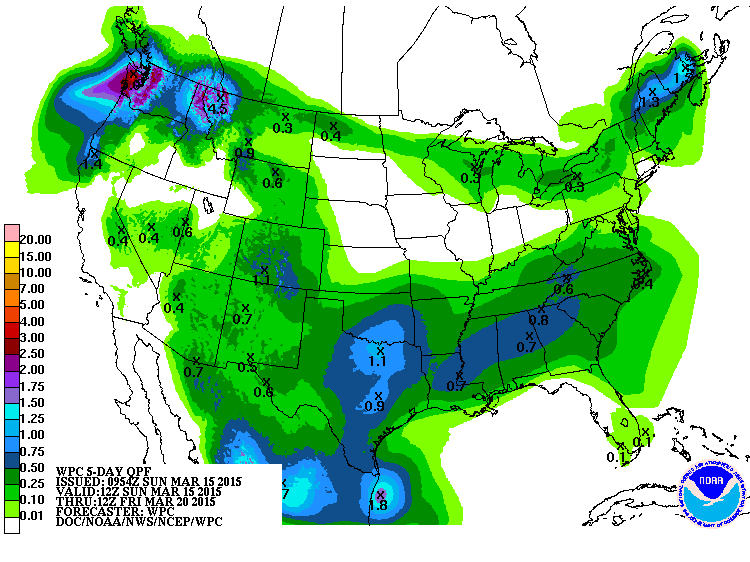
Precipitation Outlook
According to NOAA's HPC, the 5 day precipitation outlook keeps some of the heaviest moisture across the Pacific Northwest and across parts of the southern tier of the nation.
 Lack of
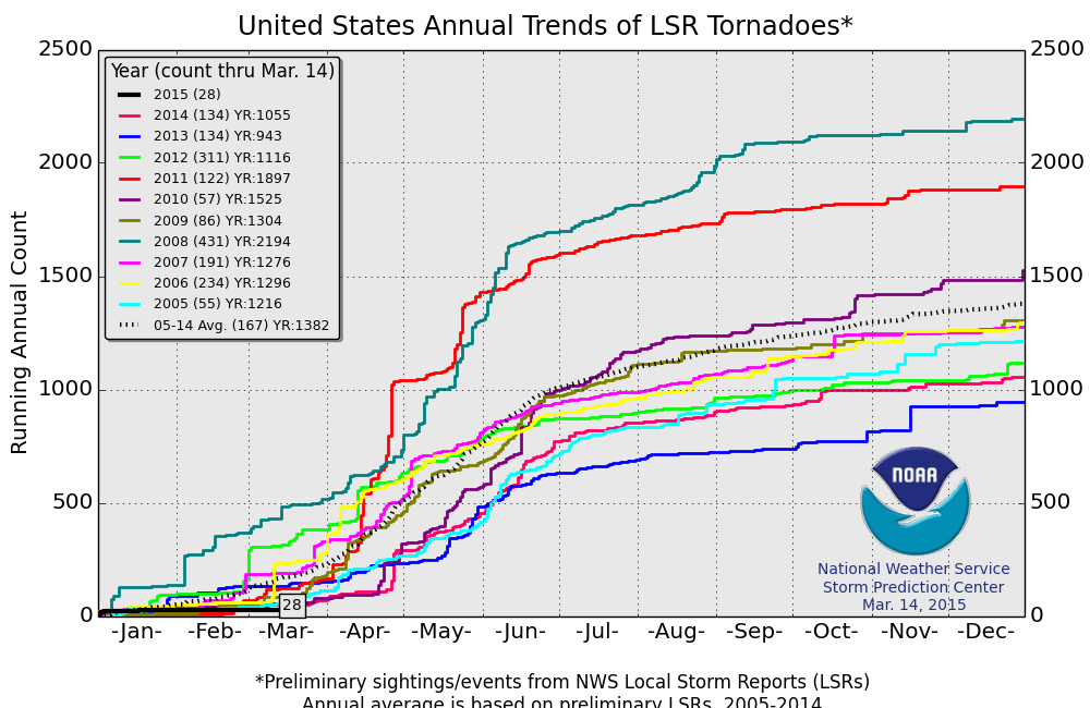
 Severe Weather So Far in 2015
According to NOAA's SPC, the PRELIMINARY tornado county so far this year (thru March 14) is only 28! The 2005-2014 average is 167. This the quietest start to a year in that time frame.
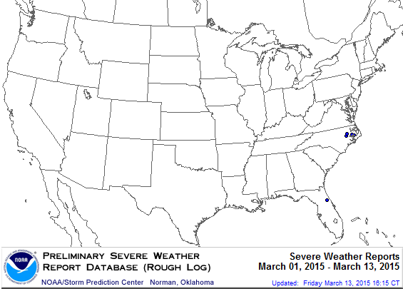
Severe Reports in March 2015
Take a look at how quite March has been so far... Through March 13th, the image below from NOAA's SPC, suggests that there have only been 7 PRELIMINARY severe reports.
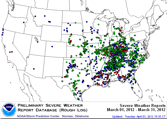
Severe Reports in March 2012
If you recall, March 2012 was VERY warm for us in Minnesota. Minneapolis actually finished 15.5F above average! Minnesota also had 1 tornado report! That warm March was also responsible for the increase in severe weather across the country. In fact, there were nearly 2,000 severe weather reports, 225 of which were tornadoes!
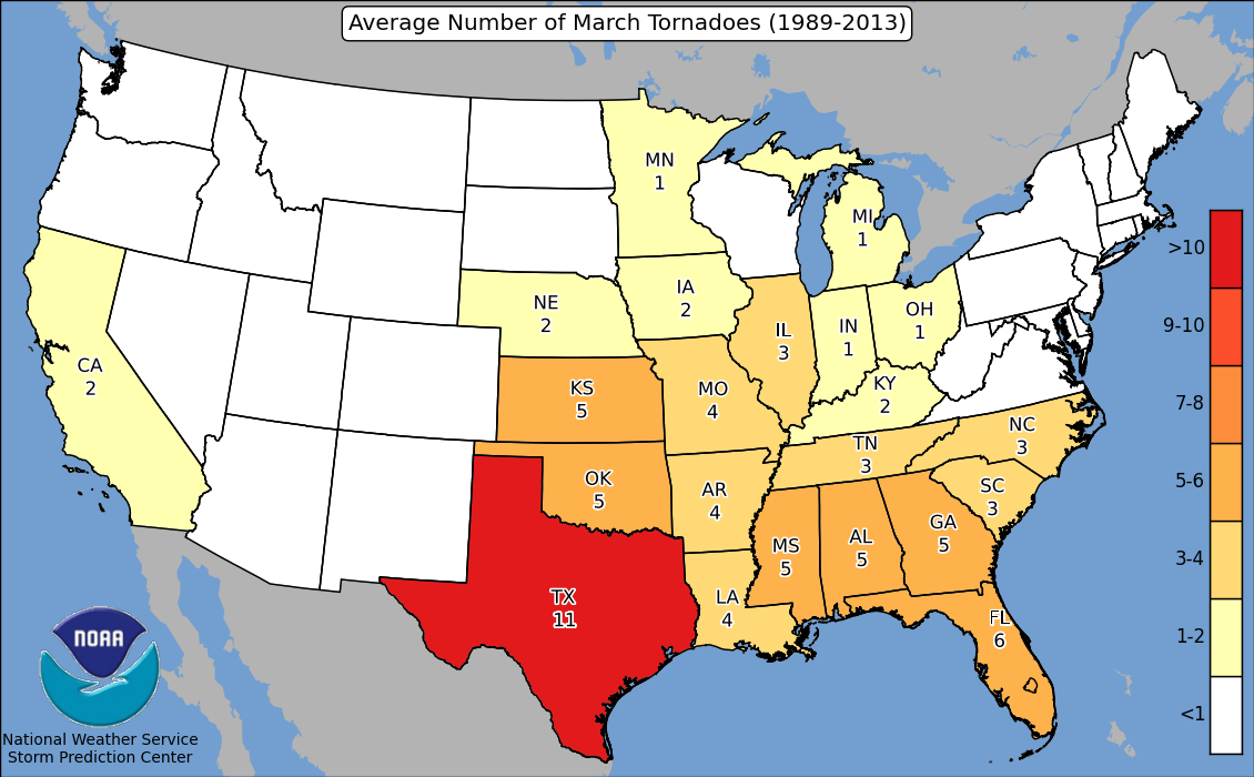
Average March Tornadoes By State
Did you know that according to the 1989-2013 average, Minnesota average 1 tornado during the month of March? The nation averages nearly 80 tornadoes during the month of March.
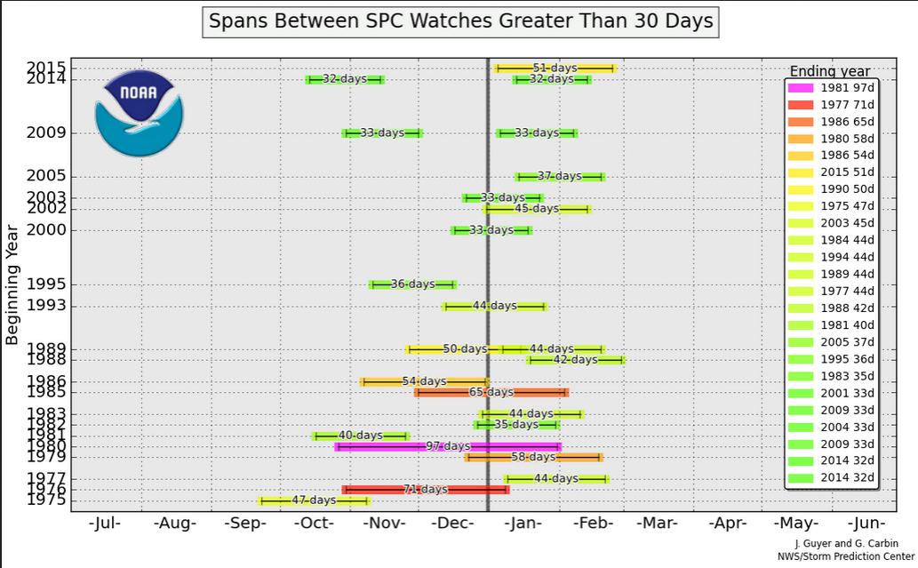
Spans Between Severe Watches
This is kind of an interesting graph... it shows the number of days between severe weather watches issued by the Storm Prediction Center. Note that we've gone nearly 50 days since the last time a severe weather watch has been issued across the country, which is the longest stretch on record since 1986!
Colder Than Average = Lack of Tornadoes
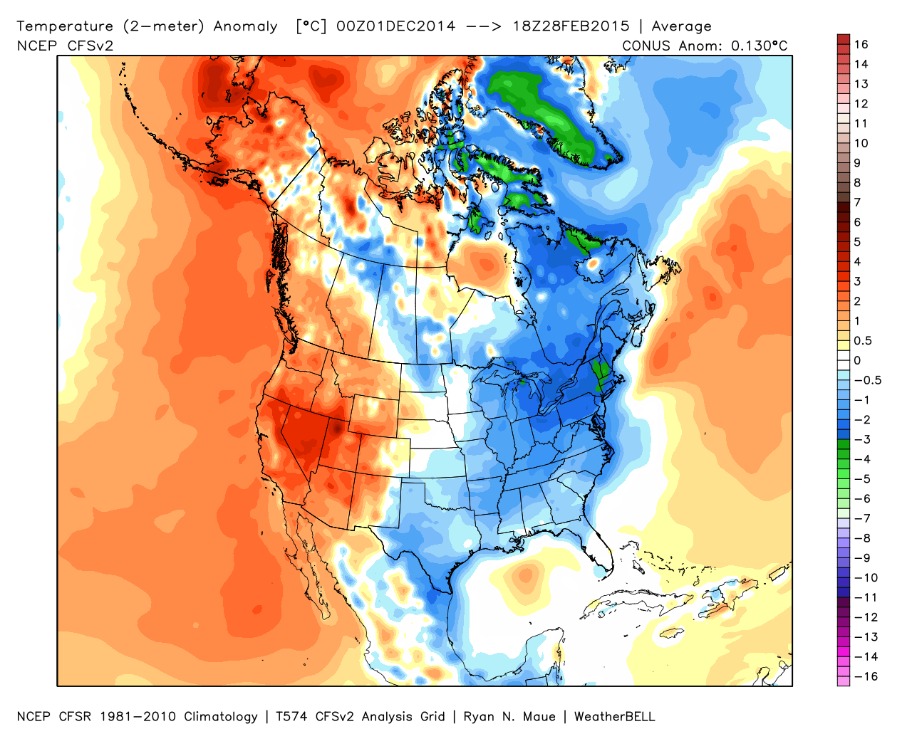
The lack of tornadoes and severe weather as of late can be attributed to the lack of warmth in the eastern half of the country. Take a look at the temperature anomaly from December-January-February; note that the eastern half of the country was cooler than average, while the weather in the western half of the country was warmer than average. It's hard to generate severe weather/tornadoes with a persistent pattern like what we've recently been in.
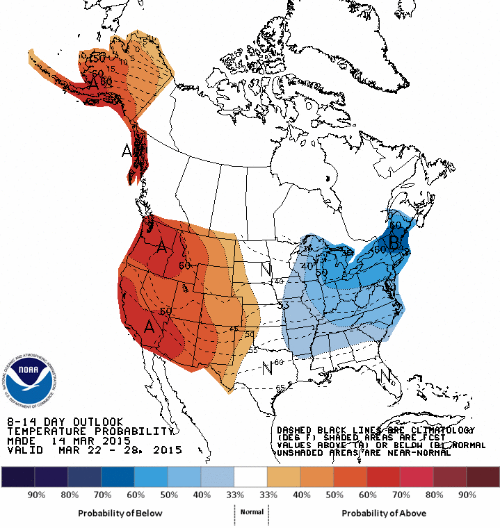
Extended Temperature Outlook
Interestingly, the extended temperature outlook from NOAA's CPC shows a fairly similar set up to what we've been dealing with over the past few months. The persistent cooler eastern U.S. and warmer western U.S./Alaska trend looks to continue in the 8 to 14 day outlook (March 22-28). This would also mean the potential for a continued lack of severe weather across the nation.
Remnants of Pam
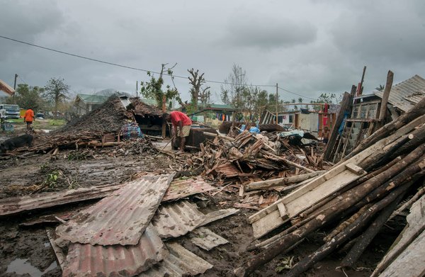
Cyclone Pam was a massive storm that hit the Southern Pacific hard. It was equivalent to a category 5 hurricane as it hit Vanuatu... This was storm as it quickly died on Sunday evening.
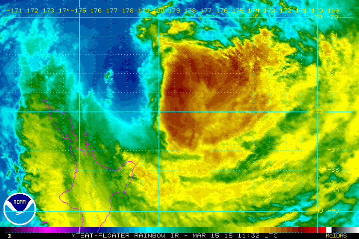
Cyclone Pam Blasts Vanuatu...
An equivalent category 5 hurricane blasted parts of the Southern Pacific...
here's more from nytimes.com:
"SYDNEY, Australia — Aid workers on the ground in the stricken South Pacific islands of Vanuatu said they feared the death toll would rise from eight after the tiny nation’s remote southern islands bore the brunt of Tropical Cyclone Pam, which tore through the archipelago on Friday. The government of Vanuatu declared a state of emergency on Sunday morning for the province of Shefa, which includes the capital, Port-Vila. The foreign minister of Australia, Julie Bishop, said that her country would provide about $3.8 million in aid, and Defense Minister Kevin Andrews said that two Royal Australian Air Force planes had left Australia for Vanuatu carrying fresh water, blankets and sleeping mats, water purification tablets and hygiene kits."
Thanks for checking in and have a great week ahead! Don't forget to follow me on Twitter @TNelsonWX

No comments:
Post a Comment