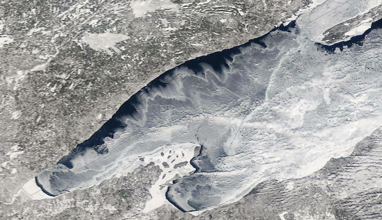
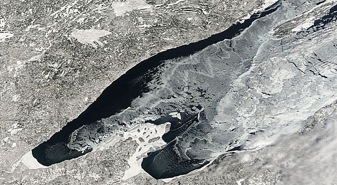
Take a look at these incredible high resolution images from a NASA satellite on March 5th and 6th over Lake Superior... Note how quickly the ice changed in 1 days time!
March 5th, 2015
March 6th, 2015
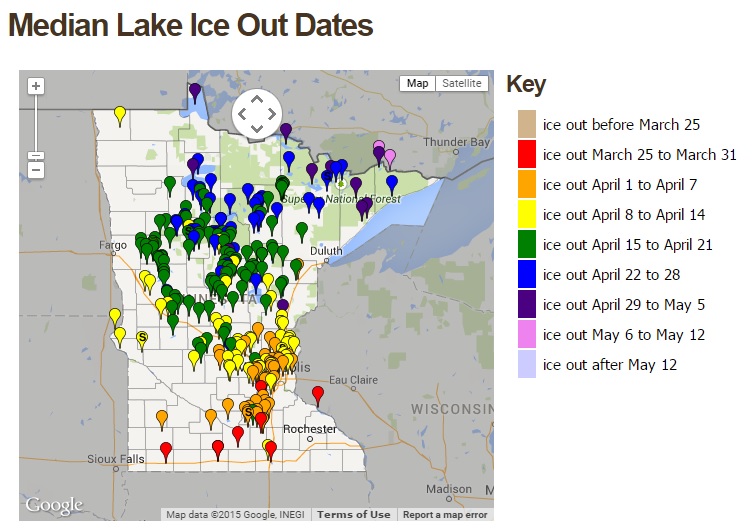
Minnesota Ice Out Dates
Here's a nice site put together by our good friends at the MN DNR, which shows Minnesota ice out dates. So far, we haven't had any official ice outs yet, but on average, lakes across far southern MN start losing there ice in late March, while those in the Twin Cities start seeing ice outs around the first half of April.
See current ice out information from the MN DNR HERE:
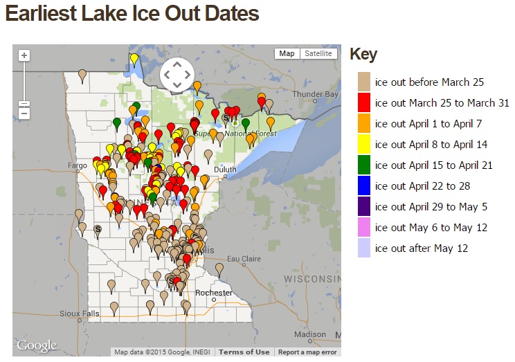
These are the earliest ice out dates on record, which suggests quite a few lakes across the state have see ice out before March 25th!
Fast Forward
By Paul Douglas
"Spring has returned. The Earth is like a child that knows poems" wrote Rainer Maria Rilke. Anticipation is building. "I've always thought that March was sort of the "Friday night of months" with the whole metaphorical weekend stretched out before you" e-mailed Great Plains CEO Rolf Nordstrom. How true.
Last winter was a pioneer winter. This winter was tough enough: less snow, to date, but colder than average as jet stream winds once again became perpetually locked in a pattern that favored cold clippers for Minnesota, record warmth out west and a punishing parade of debilitating storms from Dallas to D.C. to Boston.
So much for the groundhog's prediction: we'll see a few more wintry cold fronts (as early as next week) but this week will leave a song in your heart and a spring in your step. 50s and even a few 60s spill over into Monday of next week with readings as much as 20-25F warmer than average. Any clouds or advection fog, triggered by mild air passing over cold ground, may keep us from sampling 60s.
But you've been warned. Restlessness, fidgeting, a compulsive need to stare out the nearest window? No need to call Urgent Care. Just schedule an outdoor recess ASAP.
===========
MONDAY NIGHT: Mostly clear, quiet and mild. Low: 36. Winds: SW 5.
TUESDAY: Partly sunny, lukewarm. High: 61. Winds: SW 5.
TUESDAY NIGHT: Mostly clear and quiet. Low: 32. Winds: NW 5
WEDNESDAY: Lots of sun, still mild. High: 57
THURSDAY: Blue sky, normal for mid-April. Wake-up: 34. High: 62
FRIDAY: Mix of clouds and sun, still springy. Wake-up: 38. High: 60
SATURDAY: Sunny, a bit cooler. Wake-up: 35. High: 55.
SUNDAY: High clouds, hard to stay indoors. Wake-up: 33. High: 64.
MONDAY: Stiff wind, falling temps. Wake-up: 52. High: 57.
============
This Day in Weather History
March 10th
1948: Late winter cold wave with -44 reported at Itasca.
=============
Average High/Low For Minneapolis
March 10th
Average High: 38F (Record: 66F set in 2012)
Average Low: 22F (Record: -27F set in 1948)
=============
Sunrise/Sunset Times for Minneapolis
March 10
Sunrise: 7:34am
Sunset: 7:13pm
=============
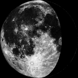
Moon Phase for March 10th at Midnight
2.5 Days Before Last Quarter
==============
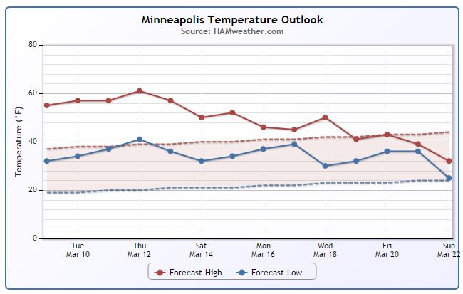
Minneapolis Temperature Trend
Mild weather continues through mid-March with highs consistently in the 40s and 50s. Note there are several days this week with highs approaching 60!! We tail off a bit toward the middle/end of the month with highs back down to near average levels.
Tuesday Weather Outlook
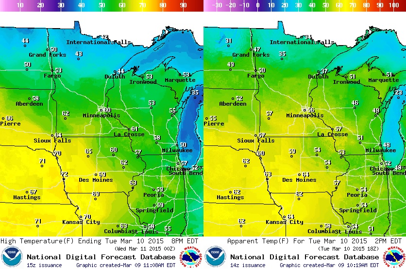
60° ? !!! Yes!! It may be a real possibility!! Highs in the 50s & 60s across the southern half of the state on Tuesday. If we hit 60° in the Twin Cities, it'll be the first time since last Fall. (Image on right is the feels like temperature for early/mid afternoon Tuesday).
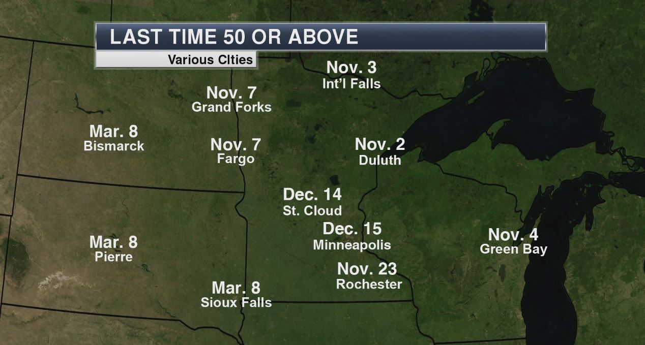
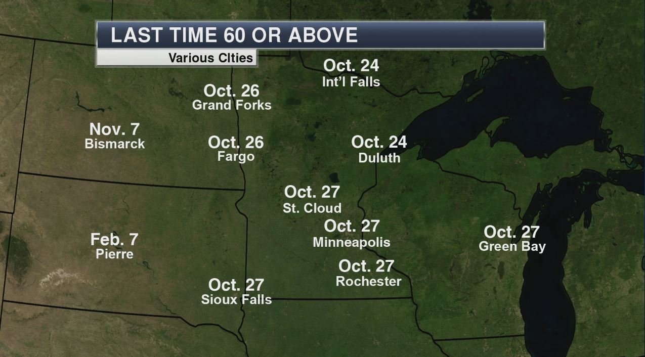
Last Time Highs in the 50s & 60s
Thanks to my good friend and colleague DJ Kayser for the images below who has compiled the last time certain locations has been in the 50s and 60s! It's been about 3.5 to 4 months since many of us have been in the 50s, while it's been nearly 4.5 months since most of us have seen the 60s.
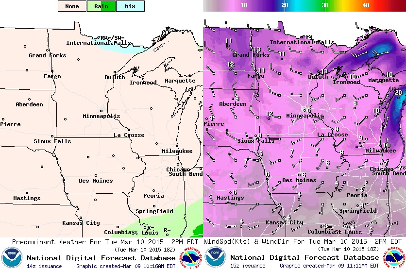
Tuesday Weather Outlook
Tuesday will most definitely be another quiet days across much of the Upper Midwest. A light WSW breeze will help to push temperatures into the 50s & 60s across much of the region with a few 70s popping up a little farther southwest.
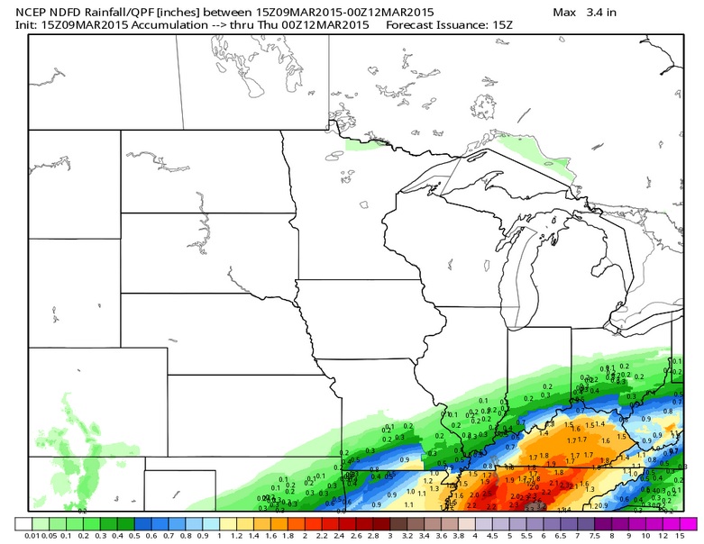
Midwest Precipitation Outlook
Much of the Upper Midwest will stay dry this week as we get missed by a larger, water-logged system across the Ohio/Tennessee Valley Tuesday/Wednesday. Through 7pm Wednesday, precipitation amounts across parts of Kentucky could approach 1" to 2"
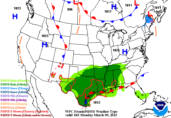
National Weather Outlook
While most across the nation stay quiet through the first half of the week, a fairly significant blob of moisture will continue to stream north out of the Gulf through the Lower Mississippi Valley parts of the Ohio/Tennessee Valley through AM Wednesday. Several inches of rainfall will be possible, which may cause some flood concerns in area rivers, streams and creeks.
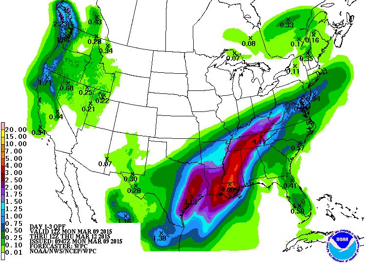
3 Day Precipitation Outlook
According to NOAA's HPC, the 3 day precipitation potential across the south-central part of the country suggests nearly 2" to 4" of rain possible as this tropical plume of moisture feeds north.
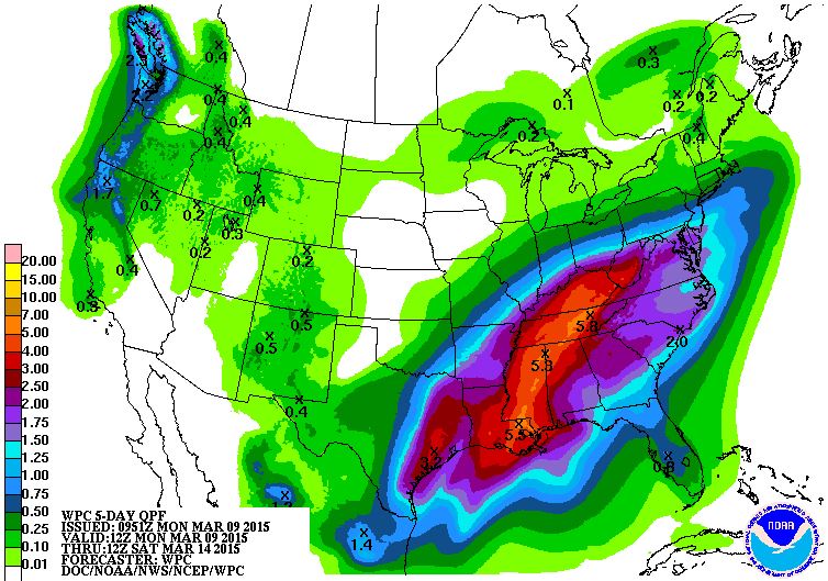
5 Day Precipitation Outlook
It appears that heavy rainfall will continue to be a possibility in these areas with the 5 day TOTAL rainfall forecast nearing 3" to 5"+ through AM Saturday.
Growing Flood Concerns
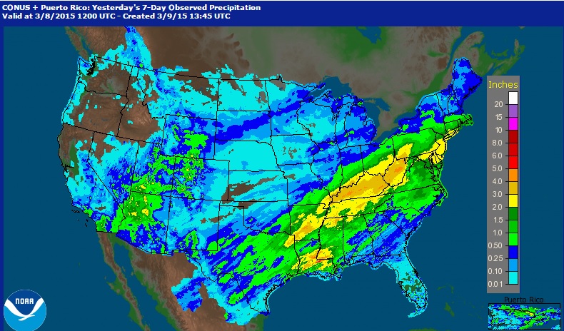
Take a look at the radar estimated precipitation over the last 7 days across the country. Note the near 2" to 4"+ liquid that has fallen in the last 7 days over some of the same areas expected to pick up an additional 3" to 5"+ through the week ahead!
Growing Flood Concerns Cont...
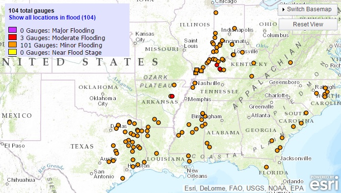
According to NOAA, the river forecasts suggest nearly 100 river gauges that could be at MINOR to MODERATE flood stage through March 18th... this will be something to watch over the next couple of weeks.
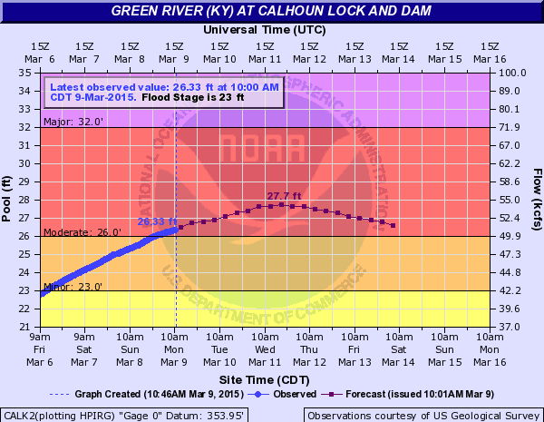
River Flooding Potential
Take a look at this NOAA river gauge forecast through March 18th along the Green River at Calhoun Lock and Dam in Kentucky. Note the how the river is forecast to swell into MODERATE flood levels through much of the week.
Dwindling Snow Pack
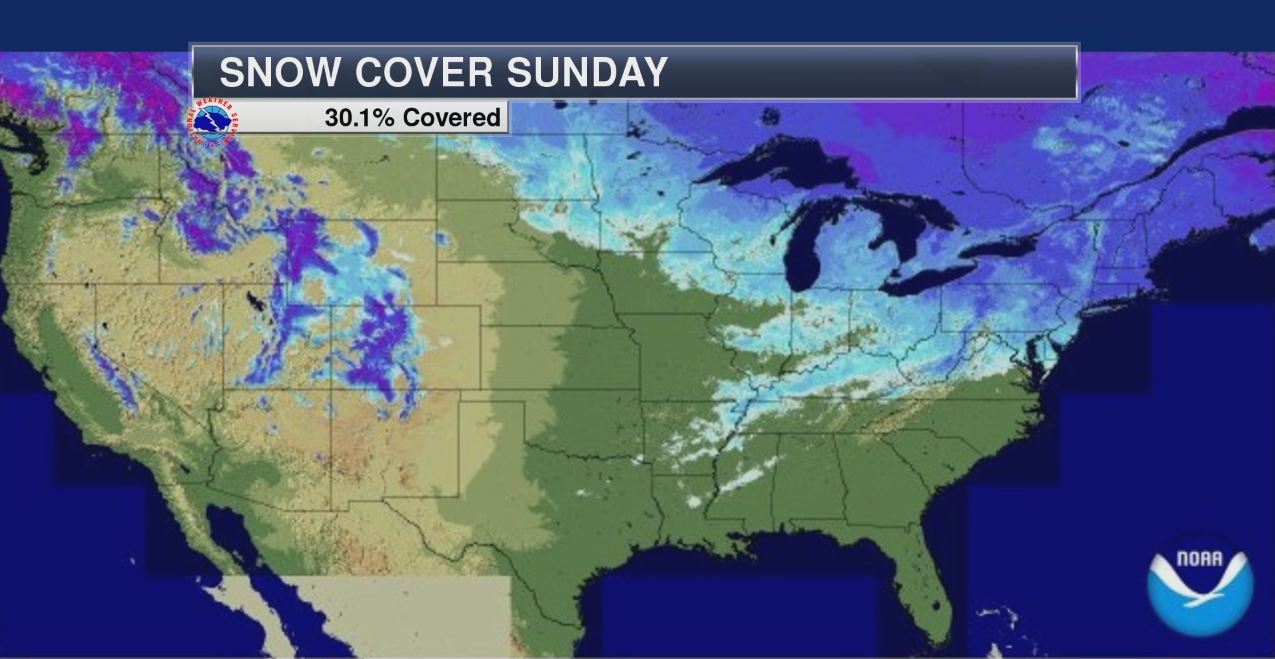
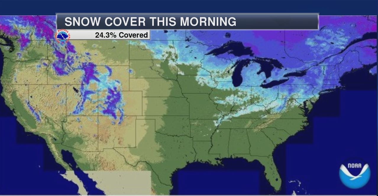
Recent Mild weather is making quick work of our snow pack across the nation. Take a look at the difference from AM Sunday to AM Monday... note that we lost nearly 6% of the national snow cover in a 24 hour period!
Thanks for checking in and have a great rest of your week! Don't forget to follow me on Twitter @TNelsonWX

Paul,
ReplyDeleteSince these days have been so warm, has the ground thawed? I'd like to dig and bury some posts.