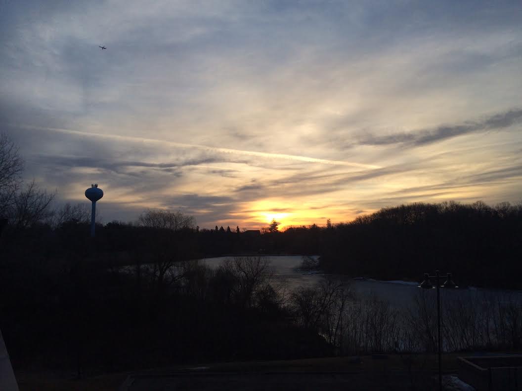
Thursday was a mild and breezy day as expected, but we fell short of the record of 69° set in 1990 due to thicker cloud cover that hung around for most of the day. Despite the lack to record warmth, we were still nearly 20° above average! It looks like the mild weather will continue through the weekend/early next week.
Thanks to my good friend and colleague D.J. Kayser for the information below regarding how rare this mild weather is for mid March.
For Minneapolis:
The average first 70 degree day is April 13th across the 143 year record.
The last 70 degree day was back on October 16th, when it reached 72.
Only two times has the first 70 degree day occurred before March 12th – March 5th back in 2000, and March 7th in 1987.
It has gotten into the 50s 20 times on March 12th, and into the 60s five times.
The 25 times it has gotten to 50 or above accounts for 17.5% of the March 12th record.
The coldest high ever on March 12th? 11 in 1956.
For St. Cloud:
The average first 70 degree day is April 15th across the 122 year record.
The last 70 degree day was back on October 24th, when it reached 72.
Only two times has the first 70 degree day occurred before March 12th – March 6th back in 1987, and March 7th in 2000.
It has gotten into the 50s ten times on March 12th, and into the 60s three times.
The thirteen times it has gotten to 50 or above accounts for 10.7% of the March 12th record.
The coldest ever high on March 12th? 11 back in 2009.
Feeling Lucky?
By Paul Douglas
March is a peculiar, vaguely terrifying month. It's as if Mother Nature was able to squeeze an entire year's worth of weather into one convenient month. In Marches past we've enjoyed our fair share of blizzards, river flooding, ice storms, subzero wind chills, 80s, freak early tornadoes and even a wildfire or two for good measure. It's a wonder we don't all have weather bunkers.
Nine years ago 9.9 inches of snow delighted Twin Cities residents. Our premature spring fling continues Friday with a high near 60F, only 20 degrees milder than average for lucky, Friday, March 13th. Northwest winds pull slightly cooler air into Minnesota, but Saturday should be pleasant; Sunday the warmer, springier day of the weekend with a strong enough southerly breeze to tip the mercury into the mid or upper 60s.
60s, with no humidity, bugs, allergies or red noisy blobs on Doppler radar, mind you. Just about as good as it gets, any month of the year.
This extended atmospheric tease won't last. After defying the laws of gravity for nearly a week models show a cooling trend next week: 30s and 40s for highs in 7-9 days? Don't retire the heavy jacket just yet. March can be fickle. And wondrous.
=============
THURSDAY NIGHT: Partly cloudy, mild and breezy. Low: 45. Winds: S 10-20.
FRIDAY: Partly sunny and breezy. High: 61. Winds: Turning WNW 10-15
FRIDAY NIGHT: Partly cloudy, less wind. Low: 36. Winds: WNW 10-15
SATURDAY: Blue sky, less wind. Hello April! High: 59.
SUNDAY: More clouds, mild breeze. Wake-up: 39. High: 65.
MONDAY: Gray, gusting, turning colder. Wake-up: 47. High: 49.
TUESDAY: Mix of clouds and sun. Wake-up: 33. High: 50.
WEDNESDAY: Sunny, still above average. Wake-up: 36. High: 56.
THURSDAY: Chance of rain showers. Wake-up: 38. High: 55.
=============
This Day in Weather History
March 13th
1851: Before the spring green-up, dry grassy areas are a fire risk. In this case prairie fires blazed in Minnesota.
=============
Average High/Low for Minneapolis
March 13th
Average High: 40F (Record 67F set in 2012)
Average Low: 23F (Record -9F set in 1895)
==============
Sunrise/Sunset Times for Minneapolis
March 13th
Sunrise: 7:29am
Sunset: 7:17pm
==============
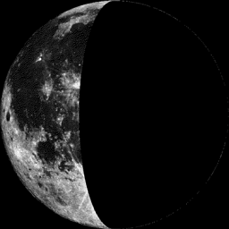
Moon Phase for March 13th
Last Quarter at 12:48pm
=================
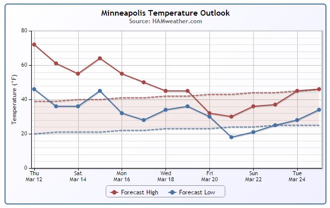
Minneapolis Temperature Trend
Hope you are enjoying your very mild second week of March. Temperatures has been extremely mild and more April-like this week with the warmest day occurring on Thursday with the mercury topping out near 70° in the Twin Cities; the first 70°+ since October 16th when we hit 72°. The good news (for folks that like the milder weather) is that we stay somewhat mild through the next week or so. Temperatures take a bit of a hit around the Vernal Equinox (Friday, March 20th) and look to stay slightly cooler than average towards the end of the month, but it won't be Arctic!
=================
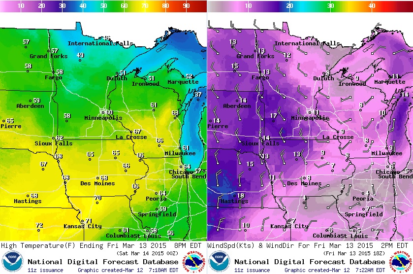
Friday Weather Outlook
It won't be quite as warm across the region on Friday, especially across the far north as the winds switch to a cooler northwesterly direction. Winds will once again be a bit on the breezy side as some of this slightly cooler air settles in.
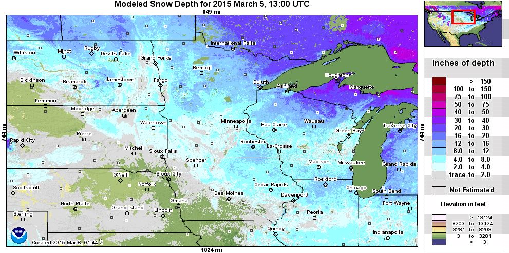
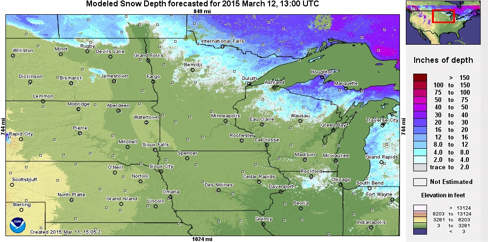
What a Difference a Week Makes!
Take a look snow depth across the region 1 week ago! Note that most locations had at least a little snow cover!
As of Thursday, March 12th - most of that snow was gone!
National Weather Outlook
Active weather continues in the eastern part of the country as a fairly large blob of moisture moves northeast out of the Gulf of Mexico. By the weekend, this system will be situated in the Northeast with wintry precipitation mixed in across the Northern New England States. We're still waiting to hear when Boston, MA will pick up an additional 2" of snow to become the snowiest season in recorded history. They are currently sitting at 105.7" of snow this season; the record is 107.6" set in 1995-96.
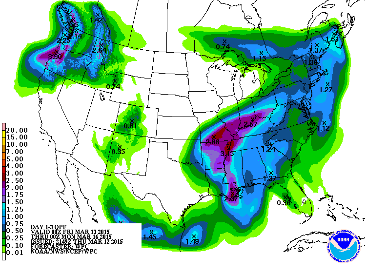
Heavy Precipitation
According to NOAA's HPC, the Mississippi/Ohio River valleys are set to pick up some pretty decent moisture over the next couple of days. An additional 1" to 2"+ can't be ruled out on top of the near 2" to 6"+ precipitation they've seen over the last 7 to 14 days. Unfortunately, more flooding is possible (especially along rivers) over the coming days.
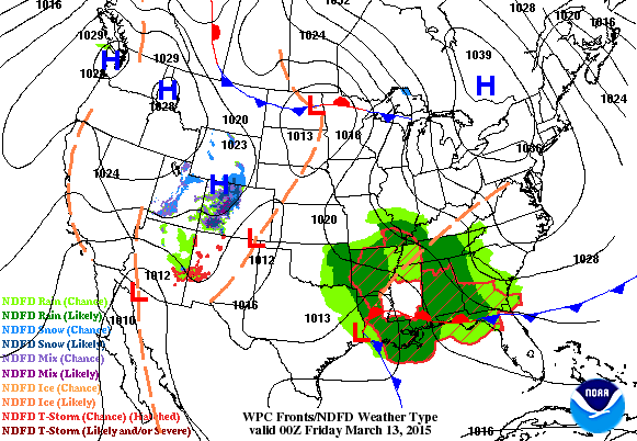
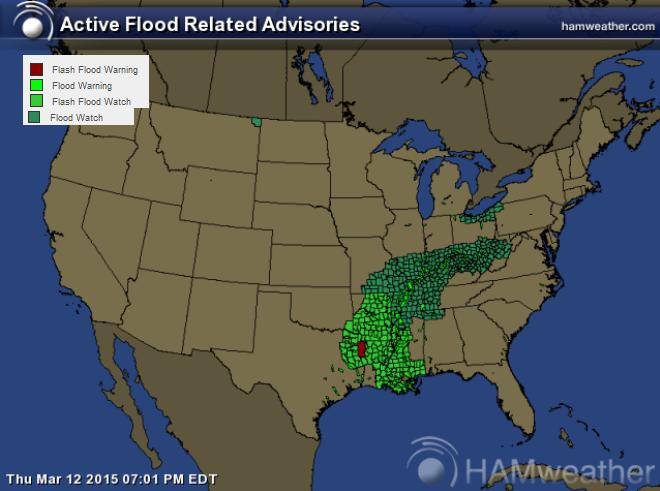
More Flood Concerns
Take a look at all the flood concerns from the Lower Mississippi Valley to the Ohio Valley. Some of these will be in place through early Saturday. Thanks to recent heavy moisture and snow melt, the ground is saturated and any additional heavy rains could lead to more flooding in low-lying areas and also for rivers, streams and creeks.
Here's the latest from the National Weather Service out of Louisville, KY. By the way, Louisville has seen 11.9" of snow so far this month and 5.01" of precipitation! Interestingly, Louisville has seen 27.6" of snow this season; Minneapolis has seen only 27.2" this season.
THE FLOOD WATCH CONTINUES FOR * PORTIONS OF SOUTHERN INDIANA AND CENTRAL KENTUCKY * FROM 2 AM EDT /1 AM CDT/ FRIDAY THROUGH SATURDAY MORNING * RAINFALL OF 1 TO 3 INCHES BEGINNING LATE TONIGHT LASTING THROUGH SATURDAY MORNING. THIS RAIN WILL FALL ON ALREADY SATURATED GROUNDS. * FLOODING OF LOW-LYING AND POORLY DRAINED AREAS. ADDITIONAL RISES ON AREA RIVERS AND STREAMS...SOME OF WHICH ARE ALREADY OUT OF THEIR BANKS.
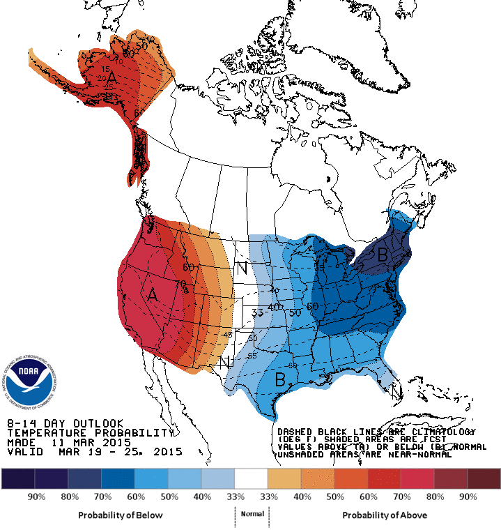
Extended Temperature Outlook
If you're enjoying the mild weather right now... enjoy EVERY minute while you can! According to NOAA's CPC, the 8 to 14 day temperature outlook suggests another blob of colder air moving into the eastern half of the country from March 19th to 25th. Meanwhile, the western half of the country and Alaska look to be warmer than average once again!
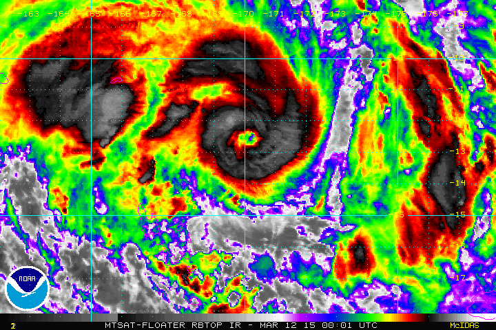
Cyclone Pam
Cyclone Pam as of early Thursday was considered a strong cyclone (major hurricane) north of Vanuatu, which is west of Fiji in the southern hemisphere. Take a look at the loop below from early Thursday, which shows a well defined eye associated with Pam!
"Tropical Cyclone Pam is moving slowly on a southerly track towards the Pacific nation, with winds of about 185 kilometres an hour. The storm is expected to reach winds of up to 280 kilometres per hour near its centre when it passes east of Vanuatu's capital, Port Villa, on Friday night. David Gibson, acting director of Vanuatu's meteorological department, said consistent forecasts were pointing to Pam intensifying into a category five storm. "This is the first time that we will experience such cyclonic intensity if it eventuates based on the forecast track," he told the ABC."
Read more about PAM from abc.net HERE:
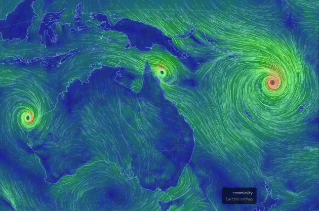
Active Southern Hemisphere
Take a look at all the storms in the southern hemisphere near Australia! The larger one on the right is Pam near Vanuatu, while the smaller ones are storm affecting northern Australia!
View the latest winds across the world HERE:
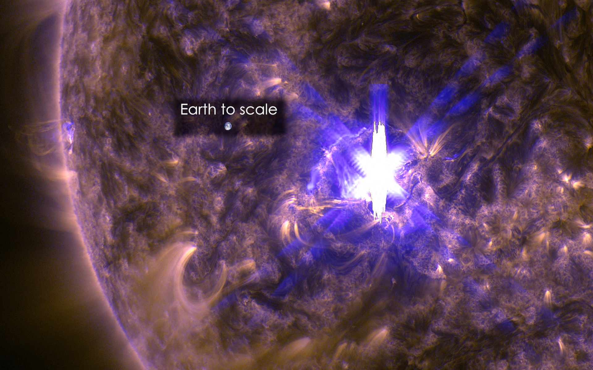
X2-FLARE AND RADIO BLACKOUT
Here's an intersting read from Spaceweather.com about
"All
week long, sunspot AR2297 has been crackling with solar flares.
Thursday, it produced a really big one! On March 11th at 16:22 UT (09:22
PDT), Earth orbiting-satellites detected an X2-class flare. The blast
zone was larger than Earth tself:"
"The
X-flare scrambled the ionosphere thoroughly so that no decametric radio
signals were supported in my part of the world," says Ashcraft. "The
ionosphere started to reform after about fifteen minutes when stations
began to reappear. (The stuff visible during the blackout was my own
observatory electricity. Nothing exterior.)"
"A coronal mass ejection (CME) was propelled into space by the explosion. However, we do not yet know if it will hit Earth. A glancing blow is possible on March 13th or 14th. Confirmation awaits the belated arrival of coronagraph data from SOHO."
See more from Spaceweather.com HERE:
"A coronal mass ejection (CME) was propelled into space by the explosion. However, we do not yet know if it will hit Earth. A glancing blow is possible on March 13th or 14th. Confirmation awaits the belated arrival of coronagraph data from SOHO."
See more from Spaceweather.com HERE:
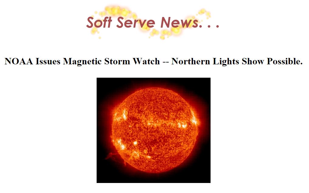
Northern Lights Possible ??
NOAA
has issued a G1 (Minor Geomagnetic Storm) watch for March 13th due to
CMEs... That means you may be able to see northern lights!
The storm watch begins on 3/12/2015 at 7:01:00 PM
"The
National Oceanic and Atmospheric Administration (NOAA) Space Weather
Prediction Center has issued a 24 hour magnetic storm watch indicating a
Coronal Mass Ejection (CME) emanating from the Sun may be heading
towards Earth. A CME is a fast moving cloud of charged particles which
can cause a Northern Lights display. The watch begins at the time
indicated above. It should be noted that the beginning of the storm
watch does not necessarily predict the arrival time of the CME cloud,
rather it indicates that, within that 24 hour period, increased activity
is expected. Real-time Aurora Borealis forecasts can be obtained at
theAurora Borealis Forecast page at Soft Serve News."
Thanks again for checking in and have a great rest of your week/weekend ahead! Don't forget to follow me on Twitter @TNelsonWX

No comments:
Post a Comment