In mathematics, the number pi or π = 3.141592653... which if you take a look at the date on March 14th, it matches the number pi! Every year, my fellow math and science nerds celebrate this date, but what makes this year so special is that this year is 2015! So, that means 3.141592653 = March 14, 2015 at 9:26:53am/pm, which won't happen again until the year 2115! This is likely a once in a lifetime event to celebrate Pi day, thus Pi Day of the Century!
"Math’s annual day in the headlines is approaching, and this year, the spotlight is extra exact. That’s because Saturday is the most accurate Pi Day of the entire 21st century. Pi Day is celebrated every March 14 in honor of the mathematical constant pi. The number, which rounds to 3.14, represents the ratio of a circle’s circumference to its diameter. With pies and puns a plenty, Pi Day has grown beyond its beginnings as a geek holiday into one of math’s more recognizable public celebrations. This year, the calendar date aligns with two additional digits of pi, 3.1415. That won't happen again until March 14, 2115."
See more from InsideHigherED.com HERE:
(image courtesy: MICHAEL NICHOLS)
By the way... if you're wondering what the sign below says, scroll to the bottom to find out :)

March Factoids
By Paul Douglas
March is a little like your favorite passive-aggressive friend: serious mood swings, capable of lukewarm winds or knee-deep slush.
It wasn't that long ago that March was, on paper, the snowiest month of the year. The latest running 30 year climate average shows March as the second snowiest (10.3 inches versus 12.2 inches in January). The big difference? January snows don't melt; they become a semi-permanent part of the landscape. With a much higher sun angle March snows are transient and fleeting. You can get half a foot one day; it's mostly gone the next.
Kent from Eden Prairie just reminded me that Little Rock, Arkansas and Dallas, Texas saw more Winter Storm Warnings from NOAA than the Twin Cities this past winter. February's cold was irritating but we got off easy compared to Americans living to our south and east. Not even close.
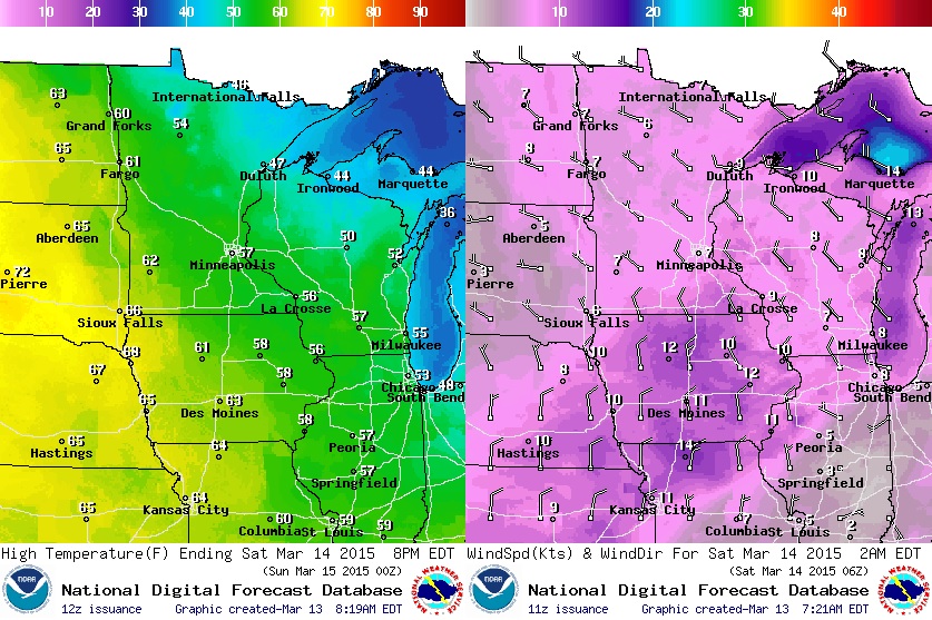
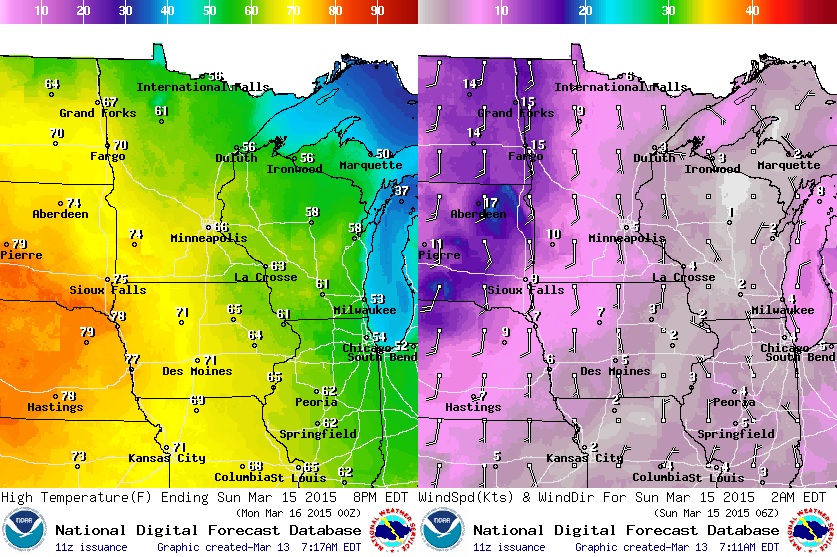
Expect blue sky and highs near 60F Saturday; a surge of milder air lures the mercury into the mid and upper 60s Sunday. Once again 70F isn't out of the question.
We cool off later next week - jackets and a few rain/snow showers possible in 5-6 days. I still don't see anything that might pass for weather drama. No tournament storms in sight.
=================
FRIDAY NIGHT: Mostly clear, quiet and cooler. Low: 36. Winds: WNW 5-15
SATURDAY: Plenty of sun, pleasant. High: 60. Winds: NW 5-10
SATURDAY NIGHT: Mostly clear, nothing rough. Low: 40. Winds: Turning SE 5
SUNDAY: More clouds, mild breeze. High: 67 (Record: 69F set in 1827).
MONDAY: Mild start, then gusty and cooler. Wake-up: 51. High: 59.
TUESDAY: Sunny, comfortably cooler. Wake-up: 27. High: 48.
WEDNESDAY: Fading sun, milder than average. Wake-up: 32. High: 53.
THURSDAY: Mostly cloudy and damp. Wake-up: 37. High: 46.
FRIDAY: Spring Begins! Few rain/snow showers? Wake-up: 36. High: 43.
=================
This Day in Weather History
March 14th
1943: Snow, sleet and ice storm south of a line from Duluth, St. Cloud and Ortonville. Heaviest ice was in the vicinities of Lake Benton, Springfield and Windom. Ice thickness was 1/2 to 3/4 inch around St. Cloud to 3/4 to 2 inches in the Pipestone, Ruthton, Lake Wilson, Slayton and Tracy. A good description of the ice was submitted in one report: "...ice was 2 inches across and 1 3/4 inch deep on wire. A little frost ice near the wire with the outside solid ice. The ice was irregular in shape." Duluth had 6 inches of snowfall at the city office with 13 inches at the airport. The ice was confined to Moose Lake and south.
1870: Severe snow and wind storm across Minnesota and Iowa. First use of the term "Blizzard" by the Estherville, Iowa Vindicator.
==================
Average High/Low for Minneapolis
March 14th
Average High: 40F (Record: 73F set in 2012)
Average Low: 24F (Record: -10F set in 1897)
==================
Sunrise/Sunset Times for Minneapolis
March 14th
Sunrise: 7:27am
Sunset: 7:18pm
==================
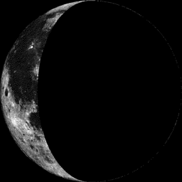
Moon Phase for March 14th at Midnight
1.5 Days After Last Quarter
===================
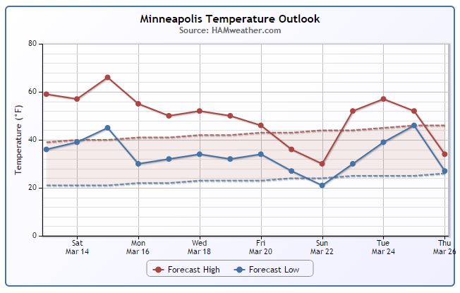
Minneapolis Temperature Trend
======================
Saturday Weather Outlook
I predict Spring fever and grilling this weekend! Highs across western and southern MN in the 50s and 60s on Saturday. Winds will be a little lighter on Saturday than they will be on Sunday, but we will stay mostly dry again.
Sunday Weather Outlook
Sunday will be a little warmer, but winds will be a little stronger later in the day making if feel a little cooler. It appears that clouds will also thicken up later in the day as a fast moving clipper approaches with a few spotty showers possible across the northern half of the state PM Sunday/Monday.
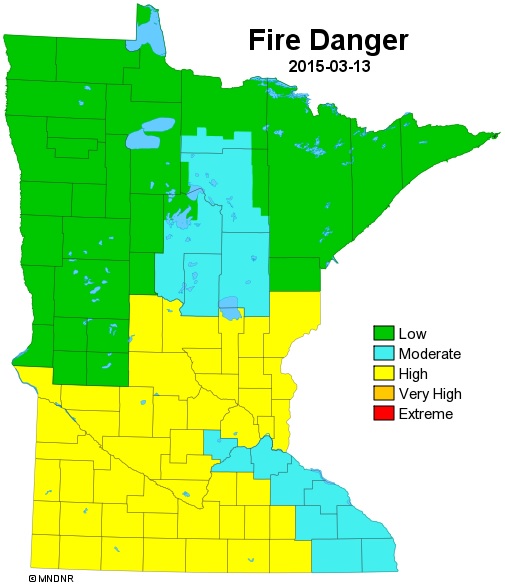
Minnesota Fire Danger Remains Elevated
With a lack of snow on the ground and dry, dead vegitation around, the fire danger remains elevated across the region. As of Thursday, the MN DNR rated the fire danger as Very High across far southwestern Minnesota and on Friday, the fire danger across much of the southern part of the state was still High.
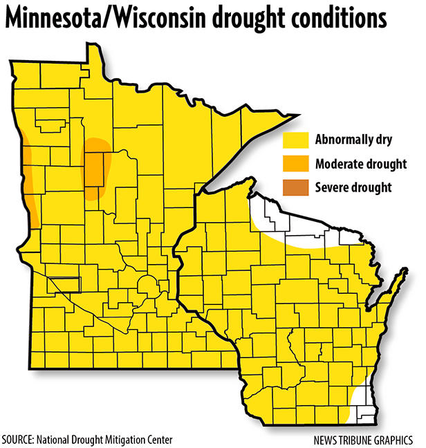
"With Snow Going, Drought Now a Concern"
With the lack of snow and precipitation, drought and wildfire season is off to an early start. Take a look at this article from the Duluth News Tribune:
"The National Drought Monitor on Thursday reported that the entire state — as well as most of Wisconsin — already is locked in an “abnormally dry’’ condition, with pockets of moderate drought already sprouting in western and north-central Minnesota counties. A string of sunny days with record temperatures into the 50s and 60s statewide have pushed fire danger levels to the “very high” level in southwestern Minnesota on Thursday and “high” as far north as Pine County where the last bits of snow are melting. Outdoor burning bans already are in effect as far north as Hinckley. Every day without rain will push the fire danger up, with warmer, sunny, windy days the most problematic. “It’s certainly a lot different than the last two winters and springs,’’ said Jean Goad, spokeswoman for the Minnesota Interagency Fire Center in Grand Rapids. “The big issue right now is that the lack of any snowpack left a lot of that brush standing upright and it’s drying out fast.” While wildfire seasons are hard to predict, timely spring rains often make up for a lack of winter snow. Fire danger will lessen when new grasses and leaves sprout and June rains fall."
(Image courtesy: National Drought Mitigation Center via News Tribune)
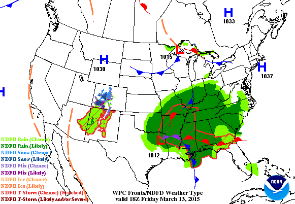
National Weather Outlook
The water-logged storm system responsible for another 1" to 2"+ rain across parts of the Lower Mississippi/Tennessee/Ohio Valley will continue tracking northeast towards the northern New England States. Rain mixed with snow and even some shovelable accumulations can't be ruled out across the far north where temperatures will be cold enough.
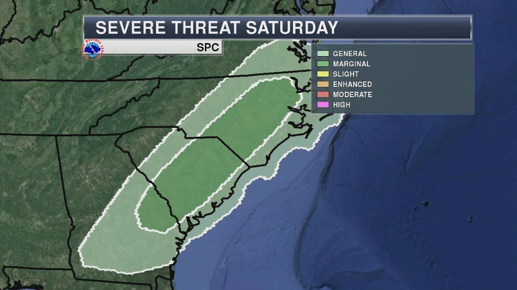
Severe Threat Saturday
The severe threat shifts east a bit on Saturday with a better chance of gusty winds through parts of the Carolinas and eastern Georgia.
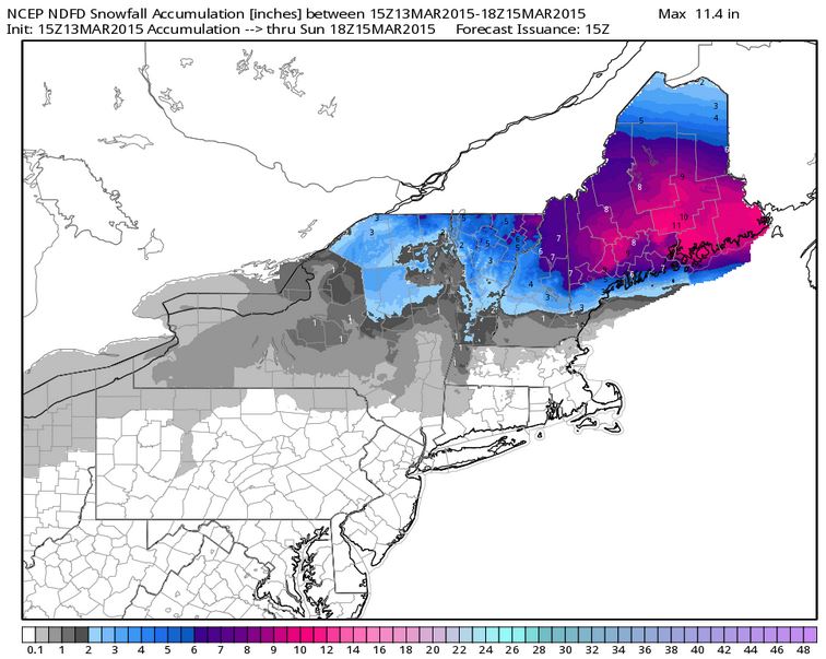
Northeast Snow Potential
Latest forecasts suggests nearly 6"+ possible for parts of the Northeast through midday Sunday! Note that Boston looks to get missed out by this. They are still only 2" away from the snowiest winter in recorded history with 105.7" currently; 107.6" is the record set in 1995-96.
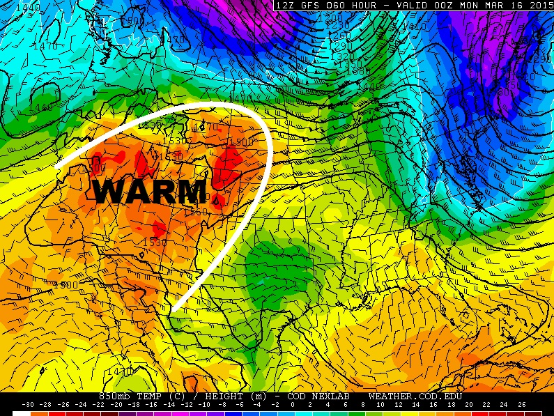
Warm Southwest
It's going to be a warm next few days in the Southwest. Take a look at the temperatures late weekend and note the blob of oranges and reds in the Southwest. Temperatures here are expected to be well above average!
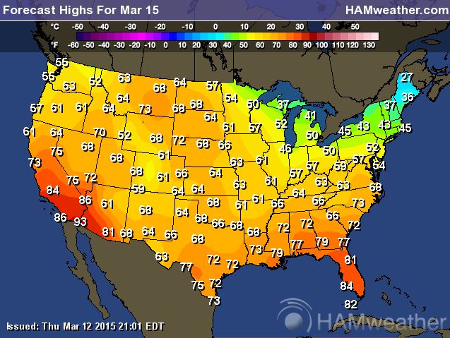
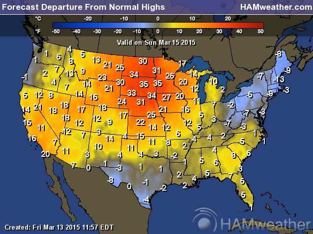
Highs Sunday
Temperatures on Sunday will be at their warmest across extreme southern California and Arizona with 90s possible there! Not only will be much warmer than average in the Southwest, but the Midwest looks quite a bit warmer than average as well with reading there nearly 20F to 35F above average!
Record Heat in the Southwest
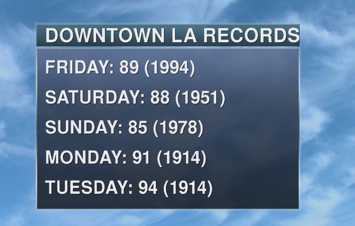
It's going to be hot is sunny south California! Take a look at the extended forecast for Los Angeles! 90s?? WHEW!
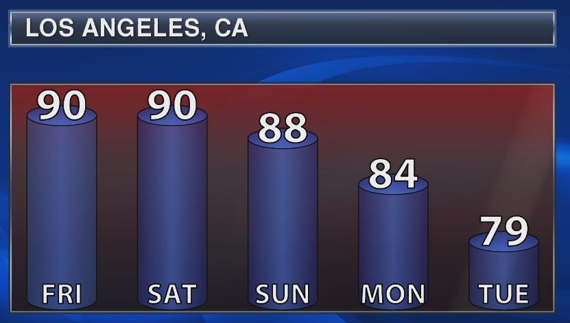
Record highs for Downtown Los Angeles are as follows, which definitely look to be threatened through Sunday!
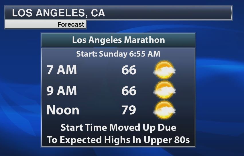
Los Angeles Marathon
Interestingly, the Los Angeles Marathon is this Sunday! Due to very warm temperatures in the forecast on Sunday, the marathon has been bumped up to an earlier start time to help with the heat. However, look at how warm it could be by noon (79F)!
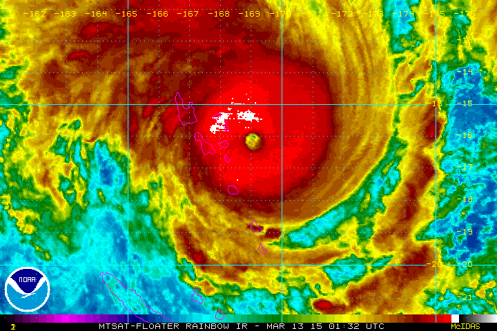
Nightmare in the South Pacific
YIKES! Take a look at this beast in the South Pacific. This was Cyclone Pam from early Thursday as it was blasting Vanuatu. Note the incredible eye structure as it drifts south!
Massive Wind Field
This was the wind field associated with Cyclone Pam on Friday as it was blasting Vanuatu. Note the winds spinning in a clockwise fashion... this is the case in the southern hemisphere, while storms in the northern hemisphere spin in a counter-clockwise fashion.
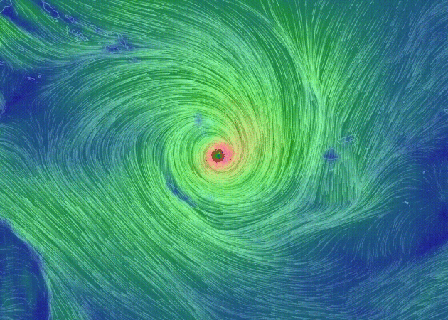
Category 5 Blasts Vanuatu
While spring is right around the corner here in the northern hemisphere, it's hurricane season in the southern hemisphere. There are currently 4 storm system in the South Pacific region, one of which was equivalent to a category 5 hurricane as it blasted the small island of Vanuatu east of Australia!
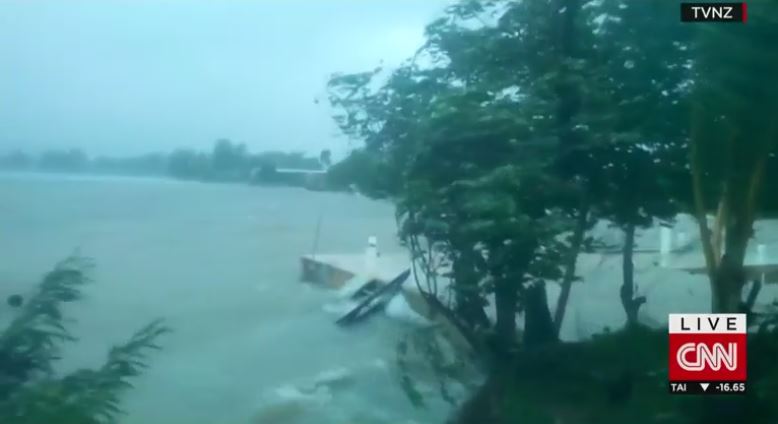
(CNN)Tropical Cyclone Pam, one of the strongest storms seen in the South Pacific in years, is churning towards the country of Vanuatu and triggering storm warnings in other island nations.
The Category 5 storm is whipping up winds of 160 miles per hour (260 kph), triggering concerns of torrential rainfall, flooding and landslides. The Vanuatu Meterological Services warned of "very destructive winds and very rough to phenomenal seas with heavy swells."
See more from CNN.com HERE:
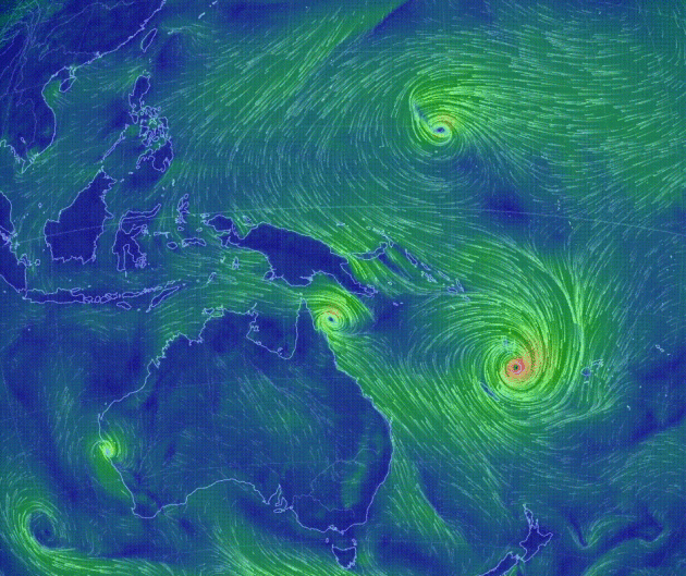
Active in the South Pacific
Take a look at all the clockwise swirls in the South Pacific Region. As of Thursday, there were 4 named storms: Olywyn, Nathan, Bavi and the strongest Pam!
Thanks for checking in and have a great weekend ahead! Don't forget to follow me on Twitter @TNelsonWX
Answer to math sign above:
√-1 = i | 2^3 = 8 | ∑ = Sum | π = Pi
i 8 sum pi !! And I liked it ! :)

No comments:
Post a Comment