Clash to Seasons
By Todd Nelson
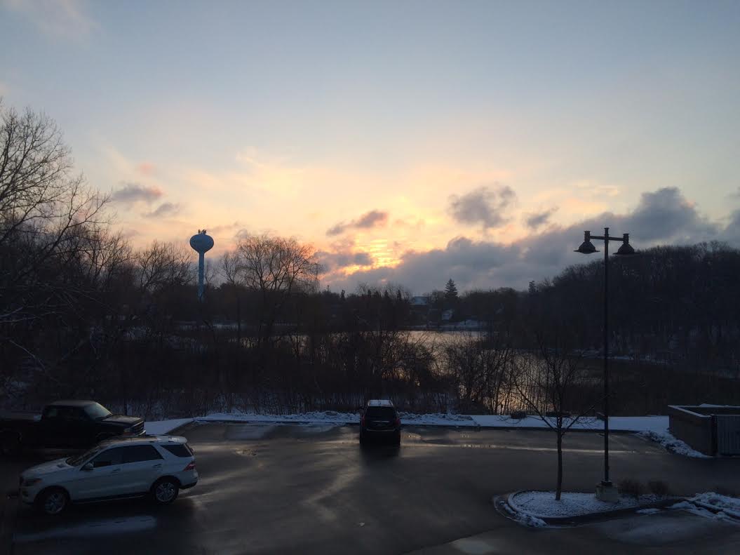
I've notice a certain jump in my step lately... maybe it's the Wheaties, maybe it's the additional daylight? We're sitting at 12.5 hours daylight in the Metro, nearly 3 hours 45 mins more daylight since the Winter Solstice 3 months ago. Get this, we'll still gain another near 3 hours of daylight by the Summer Solstice, 3 months from now.
Yes, the additional daylight is nice. Area plant life is responding; if you look close, you'll notice tree/bush buds beginning to swell. I've seen my first few robins of the season and huge flocks of grackles and starlings... boy do they go through the bird seed fast!
Spring weather has had a bit of a wintry hangover the past week, but we picked up some much needed/beneficial moisture! In fact, the Twin Cities saw nearly 0.35" liquid from Sunday to Tuesday. That's the most precipitation in a 3-day stretch since early October! Crazy huh?
Despite recent snowfall, it appears we'll end the 3rd snowiest month of the year with a snowfall deficit around 3 next Tuesday.
It'll be cool and breezy today, but temperatures warm into the 50s by Sunday/Monday. There's a shot that we could see widespread 60s in southern MN Tuesday!
===============
WEDNESDAY NIGHT: Breezy and colder. Low: 25. Winds: NW 15-25mph
THURSDAY: Breezy. More clouds than sun, chilly for late March. High: 38. Winds: NNW 10-20
THURSDAY NIGHT: Mostly clear. Less wind and chilly. Low: 17. Winds: N 5-10
FRIDAY: Who turned off the heat? Brisk. Feels like late February, but the sun is out. High: 36
SATURDAY: Breezy, turning milder with fading sun. Wake-up: 19. High: 43
SUNDAY: Rain/snow mix early. Windy. Wake-up: 34. High: 52
MONDAY: Mix of clouds and sun. Wake-up: 33. High: 53
TUESDAY: Warm, chance of widespread 60s Wake-up: 38. High: 61
WEDNESDAY: April Fools' Day. PM showers? Wake-up: 45. High: 54.
===============
This Day in Weather History
March 26th
2007: Temperature records were shattered across much of central and southern Minnesota and west central Wisconsin. The following records were set: 69 at Alexandria, 75 at Mankato, 77 at Little Falls, 79 at St Cloud, 81 at Minneapolis-St Paul and Eau Claire, 82 at Redwood Falls and 83 at Springfield.
1991: A record of 76 is set at Eau Claire.
===============
Average High/Low for Minneapolis
March 26th
Average High: 47F (Record: 81F set in 2007)
Average Low: 28F (Record: -10F set in 1996)
===============
Sunrise/Sunset Times for Minneapolis
March 26th
Sunrise: 7:05am
Sunset: 7:33pm
===============
Moon Phase for March 26th at Midnight
First Quarter
=================
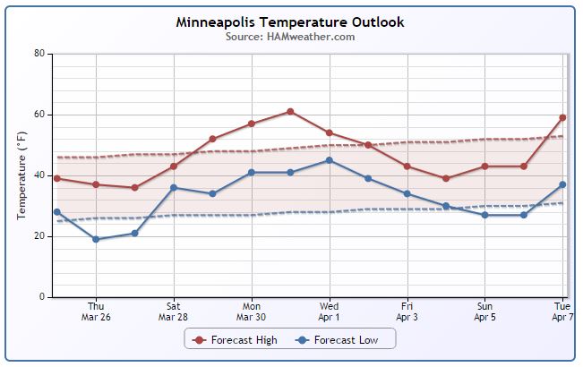
Minneapolis Temperature Trend
High temps mid March were quite nice! 50s, 60s and even a 70° reading on March 15th. Since then, we've seen slightly cooler than average temperatures with a bit of much needed precipitation (snow). We'll have to endure a few more days of cooler weather, but take a look at the warming trend into next week! It's possible that we could spike near 60° by Tuesday of next week before another potential cool down into the first weekend of April/Easter Sunday.
==============
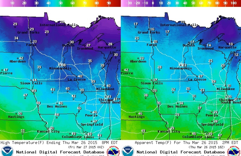
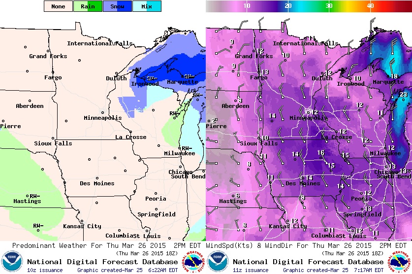
Thursday Temperature Outlook
Thursday will be a little cooler in the wake of the storm system that brought a slushy coating of snow to parts of the region PM Tuesday/AM Wednesday. Note high temperatures (left) will be in the 20s and 30s across much of the state with a few 40s possible near the Iowa border. Keep in mind that winds will still be quite brisk, so feel-like temps will more in the 10s and 20s range across the state...
Thursday Weather Outlook
The storm system exiting the region on Thursday will keep a few clouds and light snow showers in place over the Western Great Lakes Region on Thursday... Note that most of the snow potential will miss MN, but winds on the western edge of this system will still be kicking. A north/northwesterly breeze 10-20mph will make it feel more like a February day.
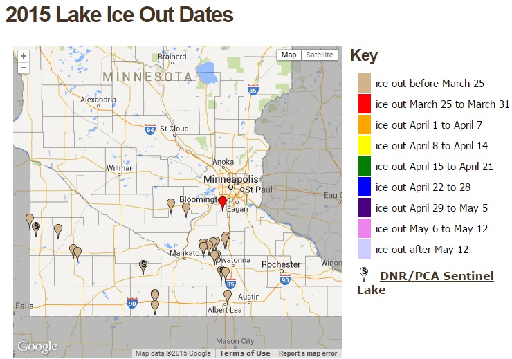
Ice Out on Some Lakes
According to the MN DNR, a number of lakes across southern MN are ice out. Cleary Lake south of the Twin Cities was one of the latest to be ice free. I expect of number of other lake to go ice free by next week as temperatures warm into the 50s and 60s across the southern half of the state.
See the MN DNR Ice Out map HERE:
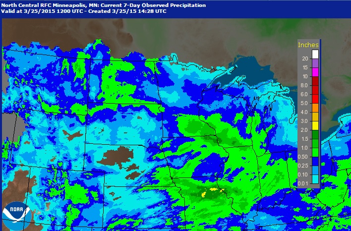
Precipitation Past 7 Days
According to radar estimates from NOAA, precipitation over the last 7 days shows some much needed precipitation across parts of the Midwest. In fact, the Twin Cities had greatest daily precipitation value of 0.20" on Sunday, March 22nd since that of December 27th, when 0.22" of liquid fell!
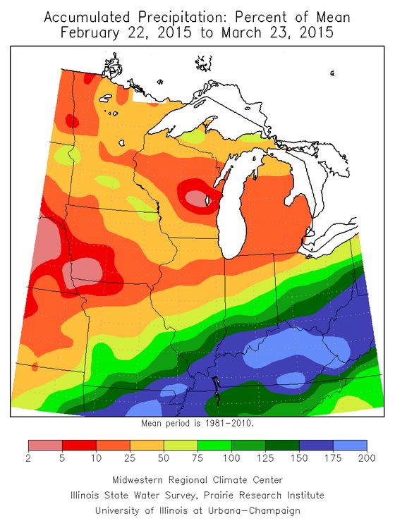
Midwest Precipitation Deficit Continues
Despite seeing some recent (beneficial) precipitation, much of the Midwest is still running well below average precipitation. The image below shows the percent of average precipitation over the last 30 days. Note that most areas northwest of the Ohio River are running below the 30-day average, some of which are have only seen 2% to 10% of their 30-day average. However, areas along and south of the Ohio River are running well above the 30-day average; 150% to 200% of average!
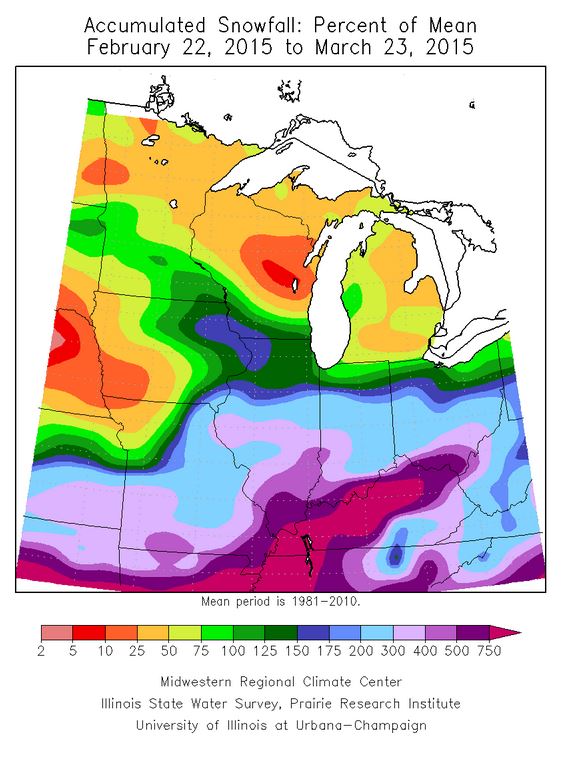
Midwest Snowfall Deficit Continues
Season to date, many areas in the Midwest are running well below their seasonal snowfall average. However, the image below shows the 30-day percent of average snowfall. Note that thanks to some recent snow across parts of MN, WI and IA, we're a little closer to average in that 30 day period, but some folks in the Ohio Valley are running nearly 250% to 750% of their 30-day average! Remember that record snows buried parts of the Ohio Valley earlier this month.
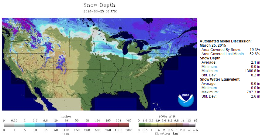
National Snow Cover
According to NOAA's NOHRSC, 19.3% of the nation was covered by snow as of March 25th. Some of the deepest snow cover still sits across the Northeast and the higher elevations of the Intermountain West.
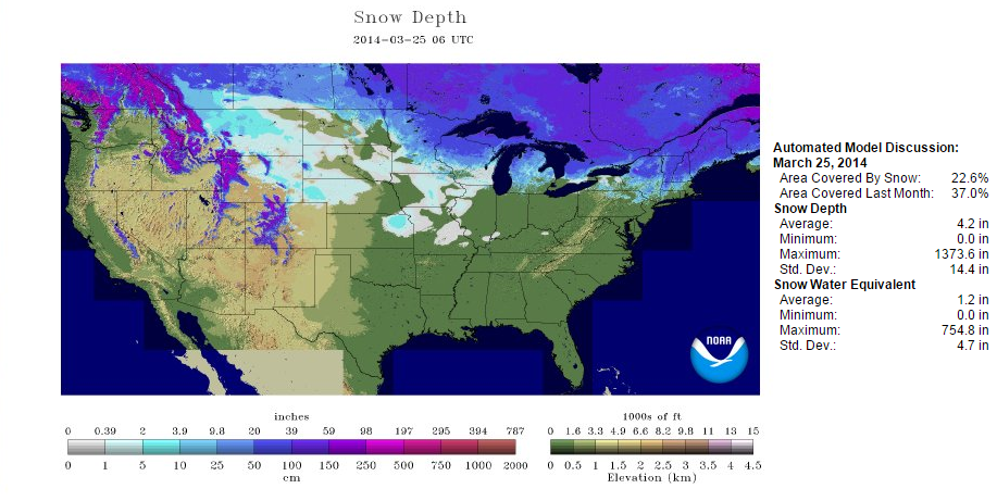
At this time last year, 22.6% of the nation was covered in snow with some of the deepest in the Northeast, Intermountain West and also across the Midwest!
New Severe Threats...
If you're a regular to NOAA's Storm Prediction Center website: www.spc.noaa.gov - you might have noticed the *NEW* look to the threat maps. Of course, this change occurred late last fall, but with a lack of severe weather over the winter and so far this year, it really hasn't been all that noticeable. Thanks to a little more active weather this week, we're really getting our first real look since some of the changes took place.
Q: Why is the SPC doing this?
A: A primary goal of these changes is to bring better consistency to the risks communicated in SPC outlooks, from the short-range Day 1 outlooks through the extended range Day 4-8 outlooks. The changes have been made based on customer feedback and to better meet their needs.
Example: Previously, a 10 percent tornado probability including a risk of a significant tornado (>=EF2) was categorized as a Slight Risk. This was the same category used for a "low end" 15 percent risk of severe thunderstorm wind and hail events. In the new scheme, a 10 percent tornado probability that includes the chance of significant tornadoes is categorized as an Enhanced Risk.
In addition, "See Text" did not convey a threat area, due to the lack of a contour in any "See Text" categorical forecast. And the previous "Slight Risk" category covered too broad a range of severe weather probability values.
See more from NOAA's SPC HERE:
**EXAMPLE** OLD OUTLOOK
This is what an SPC outlook looked like prior to October 22, 2014
(SPC Outlook for 2/10/2013)
**EXAMPLE** NEW OUTLOOK
This is what that same outlook would look like under the current SPC criteria
(SPC Outlook for 2/10/2013)
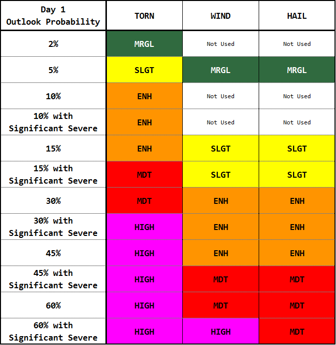
SPC Categorical Risks
Here's a better understanding of what/why each individual categorical risk would be issued for...
Day 1:
a. General Thunderstorms
- 10% or greater probability of non-severe or near severe thunderstorms.
b. Severe Category 1 - Marginal
- 2% tornado probability, or
- 5% severe hail or severe wind probability.
c. Severe Category 2 - Slight
- 5% tornado probability, or
- 15% severe hail or severe wind probability WITH OR WITHOUT 10% or greater probability of hail 2 inches or greater in diameter, or wind gusts 75 mph or greater.
d. Severe Category 3 - Enhanced
- 10% tornado probability WITH OR WITHOUT 10% or greater probability of an EF2+ tornado, or
- 15% tornado probability, or - 30% severe hail or severe wind probability WITH OR WITHOUT 10% or greater probability of hail 2 inches or greater in diameter, or wind gusts 75 mph or greater, or
- 45% probability of severe hail or wind.
e. Severe Category 4 - Moderate
- 15% tornado probability AND 10% or greater probability of an EF2+ tornado, or
- 30% tornado probability, or
- 45% severe wind probability AND 10% or greater probability of a wind gusts 75 mph or greater, or
- 45% severe hail probability AND 10% or greater probability of hail 2" or greater in diameter, or
- 60% severe wind probability, or
- 60% severe hail probability WITH OR WITHOUT 10% or greater probability of hail 2" or greater in diameter.
f. Severe Category 5 - High
- 30% tornado probability AND 10% or greater probability of an EF2+ tornado, or
- 45% or greater tornado probability WITH OR WITHOUT 10% or greater probability of an EF2+ tornado, or
- 60% severe wind probability AND a 10% or greater probability of a wind gust 75 mph or greater.
National Weather Outlook
The storm system responsible for strong to severe thunderstorms across the central U.S. will begin to tire as it moves into the Eastern U.S. - A lack of instability and dynamics will limit severe weather potential through the rest of the week, but heavier precipitation and colder temperatures will allow for some snow potential across the Northern New England States.
Precipitation Outlook
The storm system moving through the eastern two-thirds of the nation will be responsible for some decent precipitation in spots, especially in areas where thunderstorms were ongoing across the Central U.S.
Northeast Snow Potential
The probability of snow for the Northeast looks to be ramping up once again for the end of the week. According to NOAA's HPC, the probability of 4" or more is up to 50% in light blue from western New York to western Maine.
"Global warming is now slowing down the circulation of the oceans — with potentially dire consequences"
Here's an interesting article from WashingtonPost.com about how our warming climate is affecting ocean circulation...
"According to a new study just out in Nature Climate Change by Stefan Rahmstorf of the Potsdam Institute for Climate Impact Research and a group of co-authors, we’re now seeing a slowdown of the great ocean circulation that, among other planetary roles, helps to partly drive the Gulf Stream off the U.S. east coast. The consequences could be dire – including significant extra sea level rise for coastal cities like New York and Boston."
See more from WashingtonPost.com HERE:
"Large Hadron Collider Scientists Hope to Make Contact with Parallel Universe"
"Here's another interesting article from SecondNexus.com about the interesting happenings over at CERN centre in Geneva, Switzerland. They will be firing up the 'atom smasher' this week!
The staggeringly complex LHC ‘atom smasher’ at the CERN centre in Geneva, Switzerland, will be fired up to its highest energy levels ever in a bid to detect – or even create – miniature black holes.
If successful a completely new universe will be revealed – rewriting not only the physics books but the philosophy books too.
It is even possible that gravity from our own universe may ‘leak’ into this parallel universe, scientists at the LHC say.
The experiment is sure to inflame alarmist critics of the LHC, many of whom initially warned the high energy particle collider would spell the end of our universe with the creation a black hole of its own.
But so far Geneva remains intact and comfortably outside the event horizon.
Indeed the LHC has been spectacularly successful. First scientists proved the existence of the elusive Higgs boson ‘God particle’ – a key building block of the universe – and it is seemingly well on the way to nailing ‘dark matter’ – a previously undetectable theoretical possibility that is now thought to make up the majority of matter in the universe.
But next week’s experiment is considered to be a game changer."
Thanks for checking in and have a great rest of your week! Don't forget to follow me on Twitter @TNelsonWX

PakWeather.com is the first and most popular website since 2000 in Pakistan related to Weather updates and information. We provide intelligent weather Information, News, Articles, Weekly updates, Live Weather images and Much More..
ReplyDeletePakistan Weather Update
Weather & Nature Articles
Pakistan Weather Satellite
5 days Karachi Weather forecast
Interesting Facts
Global Warming in Pakistan