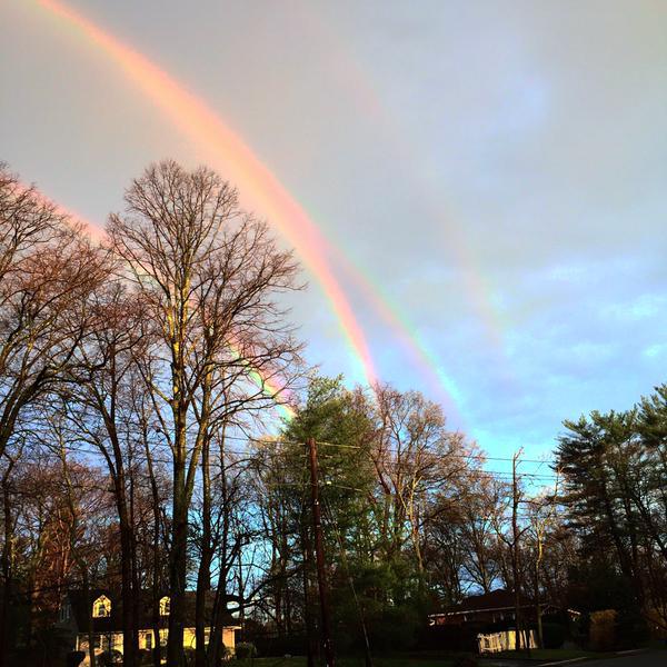
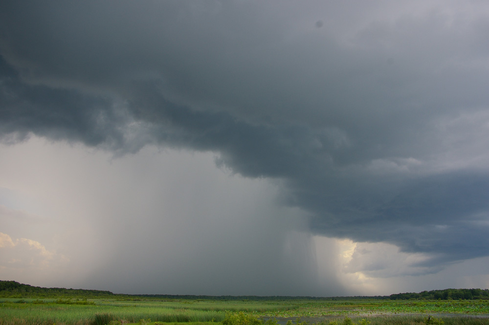
I've seen a double rain, even part of a triple rainbow, but have never heard of a quadruple rainbow, have you? Take a look at this incredible image taken by Amanda Curtis from Glen Cove, NY on April 21st, 2015. Great shot Amanda!!
(Image courtesy: Twitter Amanda_Curtis)
Brighter & Better
By Todd Nelson
We sure get spoiled quickly don't we? One week we see consistent temperatures in the 60s, 70s and 80s to frost, wind blown snow and below average temperature the next. Mother Nature has a unique way of balancing itself out. All the extreme ups and downs tend to level themselves out over time. The longer the timeframe, the closer to average you would tend to be.
However, one disturbing trend over recent years is the extreme drought in the Western U.S., especially in California. Efforts to control water usage and mitigate additional drought concerns continue. In a recent report, Californians are being asked to cut water usage by 25% in hopes to conserve an additional 1.3 million acre-feet this year. Reservoir levels are running significantly lower than average; it's a trend that is weighing heavy on the minds of many.
A weak storm system moves into the Western U.S. over the next few days; precipitation amounts will be fairly low. We get a piece of this system on Friday with a few cool rain showers lingering into the early weekend.
Temps are still cooler than avg., but at least things are heating up with my favorite hockey team...
GO WILD!!
==================
WEDNESDAY NIGHT: Mostly clear and chilly! Lighter winds. Low: 29. Winds: NW 5-15mph
THURSDAY: Frosty start. Brighter and better, less wind. High: 52. Winds: NW 5-10mph
THURSDAY NIGHT: Mostly clear, not quite as cold. Low: 35. Winds: light SE
FRIDAY: Mostly cloudy, scattered rain showers High: 52.
SATURDAY: Damp start, partly sunny by afternoon. Wake-up: 38. High: 54.
SUNDAY: A little warmer and more sun. Wake-up: 38. High: 60.
MONDAY: Clouds thicken, rain develops late. Wake-up: 45. High: 58.
TUESDAY: Breezy. Rain/snow mix possible. Wake-up: 40. High: 54.
WEDNESDAY: Windy. Lingering sprinkles/flurries. Wake-up: 39. High: 54.
===================
This Day in Weather History
April 23rd
1990: A record of 88 degrees is set at Redwood Falls.
====================
Average High/Low for Minneapolis
April 23rd
Average High: 62F (Record: 86F set in 1990)
Average Low: 41F (Record: 19 set in 1910)
====================
Sunrise/Sunset Times for Minneapolis
April 23rd
Sunrise: 6:14am
Sunset: 8:08pm
====================
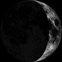
Moon Phase for April 23rd at Midnight
1.7 Days Before First Quarter
=====================
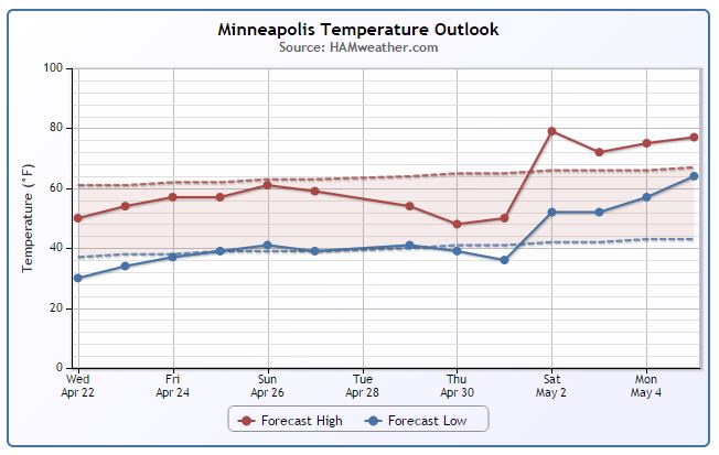
Minneapolis Temperature Trend
It appears that the coldest weather is now behind us (for a little while). We will gradually warm back to near average temperatures by the weekend, but extended forecasts are suggesting another brief cool down by the middle/end of next week. Regardless of what happens through the end of the month (temperature-wise), we still are seeing a warmer/more unsettled trend into early May.
===================
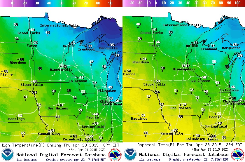
Thursday Temperature Outlook
With weather conditions continually improving through the week, Thursday won't be all that bad. Other than being cooler than average, we'll have more sun and lighter winds! Tempreatures will warm into the 40s and 50s across the state (cooler than average by 10F or so), but with the wind, it'll still feel like the 30s, 40s across much of the state.
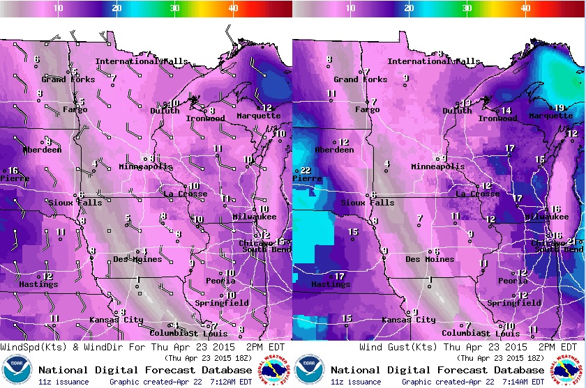
Thursday Wind Outlook
Nice to see winds finally subsiding! Westerly winds will still be a bit breezy (10mph to 15mph) across the eastern part of the state, but not nearly as nagging as it was earlier this week.
Thursday Weather Outlook
The large upper level low will continue to slowly moving east on Thursday. Although we'll still be a bit cool and breezy, we'll have lots of sunshine across the Upper Midwest! Grab your light jacket and sunglasses.

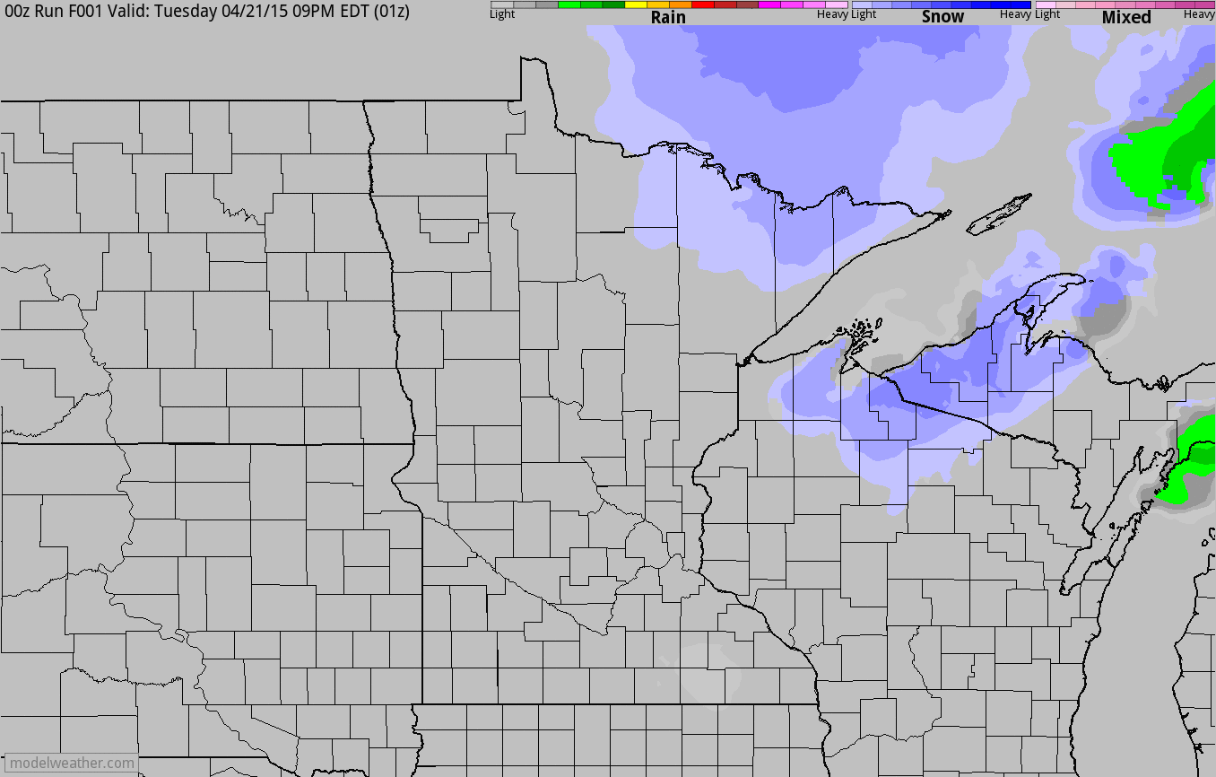
Simulated Radar
The simulated radar loop below shows the remnant snow showers from PM Tuesday/AM Wednesday slowly moving east. Thursday looks like a mostly quiet day across the region, but note the spotty showers moving back into the region by Friday.
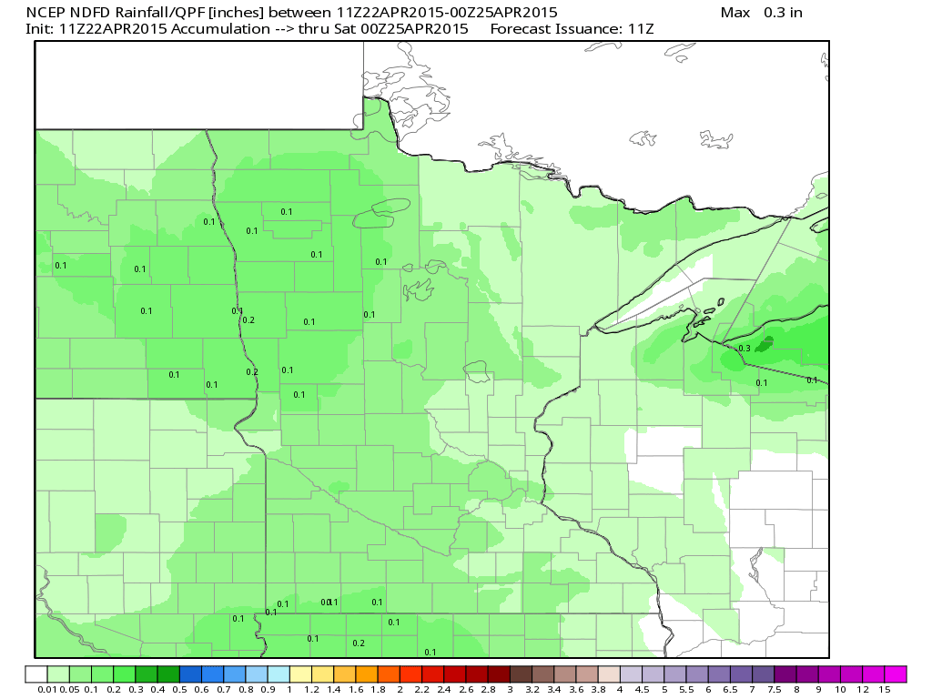
Precipitation Outlook
Weather conditions will sour a bit towards the end of the week with rain showers moving in on Friday; up to 0.10" to 0.20" may be possible through 7pm Friday.
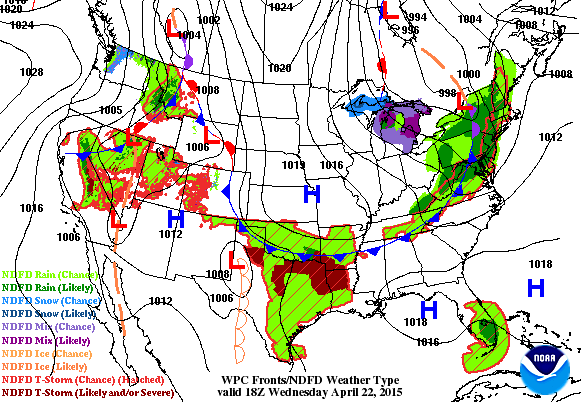
National Weather Outlook
Nice to see that stubborn, slow moving, large upper level low moving east of the Great Lakes Region through the end of the week. Weather conditions will slowly improve for folks in the northeast quadrant of the nation, but another storm system will quickly develop behind it and move into the middle part of the country through the 2nd half of the week. Widespread showers and storms will be possible with mountain snow, strong/severe storms in the Plains and pockets of heavy rain.
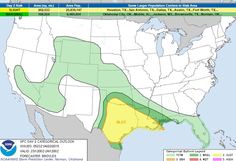
Severe Threat Thursday
...SUMMARY...
ISOLATED TO SCATTERED THUNDERSTORMS...WITH SOME PRODUCING LARGE HAIL
AND WIND DAMAGE...WILL BE POSSIBLE THURSDAY ACROSS MUCH OF
TEXAS...SOUTHERN OKLAHOMA AND LOUISIANA. MARGINALLY SEVERE STORMS WITH
HAIL AND STRONG WIND GUSTS MAY OCCUR IN PARTS OF THE CENTRAL GULF
COAST...WEST-CENTRAL TEXAS AND CENTRAL OKLAHOMA. THUNDERSTORMS MAY ALSO
DEVELOP ACROSS PARTS OF THE OZARKS...CENTRAL PLAINS...CENTRAL
ROCKIES...INTERMOUNTAIN WEST...DESERT SOUTHWEST AND SIERRA NEVADA.
...SRN PLAINS AND LA... AN UPPER-LEVEL RIDGE IS FORECAST TO MOVE EWD
ACROSS THE SRN AND CNTRL PLAINS ON THURSDAY OVER THE TOP OF A WARM
SECTOR LOCATED ACROSS THE ERN HALF OF TX INTO LA. SFC DEWPOINTS ARE
FORECAST TO BE IN THE LOWER 70S F IN CNTRL AND EAST TX RESULTING IN
STRONG INSTABILITY. IN SPITE OF THIS...SUBSIDENCE DUE TO THE UPPER-LEVEL
RIDGE WILL HELP TO KEEP CONVECTIVE INITIATION ISOLATED THURSDAY
AFTERNOON AND CONCENTRATED ALONG BOUNDARIES. AS LOW-LEVEL CONVERGENCE
INCREASES ON THE MESOSCALE...A FEW CONVECTIVE CLUSTERS COULD DEVELOP BY
EARLY THURSDAY EVENING AND PERSIST INTO THE OVERNIGHT PERIOD. THE MOST
FAVORABLE AREA FOR CONVECTIVE INITIATION WOULD BE ON THE WRN EDGE OF THE
MOIST SECTOR ALONG THE I-35 CORRIDOR AND NEAR A WARM FRONT EXTENDING
SEWD ACROSS ARKLATEX. NAM FORECAST SOUNDINGS FOR WACO AND DALLAS AT
00Z/FRI SHOW IMPRESSIVE THERMODYNAMICS WITH MLCAPE OF 3500 TO 4500 J/KG
AND STEEP LAPSE RATES NEAR 7.5 C/KM FROM 850 TO 500 MB. IN
ADDITION...VEERING WINDS WITH HEIGHT BELOW 700 MB AND WLY FLOW ALOFT
WILL CREATE STRONG DEEP-LAYER SHEAR ACROSS MUCH OF THE WARM SECTOR. THIS
SHOULD SUPPORT SUPERCELLS AND LARGE HAIL IN AREAS WHERE STORMS CAN
INITIATE. WIND DAMAGE COULD ALSO OCCUR WITH CLUSTERS THAT CAN ORGANIZE
DURING THE EARLY EVENING. A TORNADO OR TWO CAN NOT BE RULED OUT WITH
SUPERCELLS THAT CAN BECOME DOMINANT. FURTHER TO THE EAST ACROSS
LA...THUNDERSTORMS COULD ALSO DEVELOP IN A MODERATELY UNSTABLE AND
STRONGLY SHEARED ENVIRONMENT. ALTHOUGH LAPSE RATES ARE NOT AS STEEP AS
ACROSS TX...ANY CONVECTIVE CLUSTER THAT CAN ORGANIZE COULD DEVELOP A
WIND-DAMAGE THREAT DURING THE LATE AFTERNOON AND EARLY EVENING.
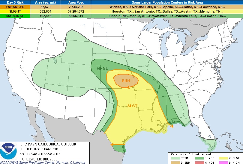
Severe Threat Friday
...SUMMARY...
SEVERE THUNDERSTORMS WITH LARGE HAIL...WIND DAMAGE AND SOME TORNADOES
WILL BE POSSIBLE ACROSS ACROSS THE CENTRAL PLAINS SOUTHWARD INTO THE
SOUTHERN PLAINS AND EASTWARD INTO THE LOWER MISSISSIPPI VALLEY.
THUNDERSTORMS MAY ALSO DEVELOP ACROSS PARTS OF THE CENTRAL GULF
COAST...CENTRAL HIGH PLAINS AND INTERMOUNTAIN WEST. ...CNTRL PLAINS...
AN UPPER-LEVEL TROUGH IS FORECAST TO MOVE EWD INTO THE CENTRAL PLAINS ON
FRIDAY AS A SFC LOW DEEPENS ACROSS THE CNTRL HIGH PLAINS. BACKED SELY
WINDS AT THE SFC WILL ALLOW LOW-LEVEL MOISTURE TO GRADUALLY INCREASE
ACROSS THE CNTRL PLAINS DURING THE DAY WITH THE MOISTURE AND INSTABILITY
AXIS SETTING UP ACROSS SCNTRL AND NRN KS. SFC DEWPOINTS ARE FORECAST TO
BE AROUND 60 F ALONG THIS CORRIDOR WITH MODERATE INSTABILITY DEVELOPING
BY AFTERNOON. MODEL FORECASTS SUGGEST THAT THUNDERSTORMS COULD INITIATE
ALONG THE WEST EDGE OF THE INSTABILITY AXIS IN THE MID TO LATE
AFTERNOON WITH A COMPLEX OF STORMS MOVING EWD ACROSS CNTRL AND ERN KS
DURING THE LATE AFTERNOON AND EARLY EVENING. NAM FORECAST SOUNDINGS AT
00Z/SAT FOR SALINA AND EMPORIA KS SHOW MLCAPE IN THE 2000 TO 2500 J/KG
RANGE WITH STEEP LAPSE RATES AND 40 KT OF 0-6 K SHEAR. THIS ENVIRONMENT
SHOULD BE FAVORABLE FOR SUPERCELLS WITH LARGE HAIL AND WIND DAMAGE. THE
NAM...GFS AND ECMWF SOLUTIONS AGREE THAT A 40 TO 50 KT LOW-LEVEL JET
WILL DEVELOP ACROSS SRN AND ERN KS DURING THE EARLY EVENING AS THE LEFT
EXIT REGION OF THE MID-LEVEL JET PASSES OVER THE AREA. THIS COULD MAKE
CONDITIONS FAVORABLE FOR TORNADOES WITH THE MORE DOMINANT SUPERCELLS.
THE SEVERE THREAT INCLUDING A RISK FOR LARGE HAIL AND WIND DAMAGE SHOULD
CONTINUE EWD INTO MO DURING THE EVENING AND MAY REACH THE MID MS VALLEY
DURING THE OVERNIGHT PERIOD. ...SRN PLAINS/ARKLATEX/LOWER MS VALLEY...
AN UPPER-LEVEL RIDGE IS FORECAST TO MOVE INTO THE LOWER TO MID MS VALLEY
ON FRIDAY. A WARM SECTOR SHOULD BE IN PLACE FROM CNTRL TX EWD TO THE
LOWER MS VALLEY WITH A LOW-LEVEL JET FORECAST TO DEVELOP ACROSS EAST TX
AND LA DURING THE DAY. LIFT ASSOCIATED WITH THE LOW-LEVEL JET AND
LARGE-SCALE ASCENT ASSOCIATED WITH AN APPROACHING UPPER-LEVEL TROUGH MAY
SUPPORT SCATTERED TO WIDESPREAD THUNDERSTORM DEVELOPMENT ACROSS THE
REGION AS A 60 TO 75 KT MID-LEVEL JET PASSES BY TO THE NORTH. MCS
DEVELOPMENT WILL BE POSSIBLE FROM THE ARKLATEX SWD ACROSS EAST TX...LA
AND INTO WRN MS. NAM FORECAST SOUNDINGS AT 21Z FRIDAY FOR MONROE LA EWD
TO THE MS RIVER SHOW MLCAPE AROUND 1500 J/KG WITH 45 TO 50 KT OF 0-6 KM
SHEAR. THIS SHOULD BE FAVORABLE FOR SUPERCELL DEVELOPMENT ALTHOUGH
CONVECTION COULD ALSO ORGANIZE INTO LINES AS STORMS CONGEAL DURING THE
AFTERNOON. WINDS AT LOW-LEVELS ARE FORECAST TO BE SOMEWHAT VEERED TO THE
SSW WITH UNIDIRECTIONAL WIND PROFILES IN PLACE ABOVE 850 MB. THIS
SHOULD BE FAVORABLE FOR WIND DAMAGE ESPECIALLY IF A COLD POOL CAN
ORGANIZE ACROSS THE REGION FRIDAY AFTERNOON. LARGE HAIL...WIND DAMAGE
AND A TORNADO THREAT COULD DEVELOP WITH SUPERCELLS AND THE MORE INTENSE
LINE SEGMENTS.
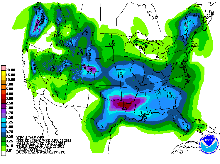
Precipitation Outlook
According to NOAA's HPC, the precipitation outlook through AM Monday suggests pockets of heavy rainfall across the south-central part of the country as well as area along the Front Range.
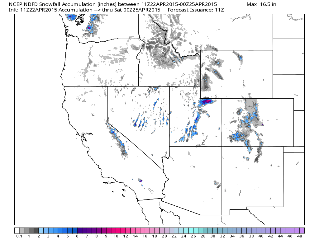
Western Snowfall
As our next storm system moves into the western half of the country over the next few days, snowfall will be possible across the high elevations. There may be pockets of heavier snowfall, but it will be confined to the peaks. Regardless, it is nice to see snow/precipitation in the Western U.S.!
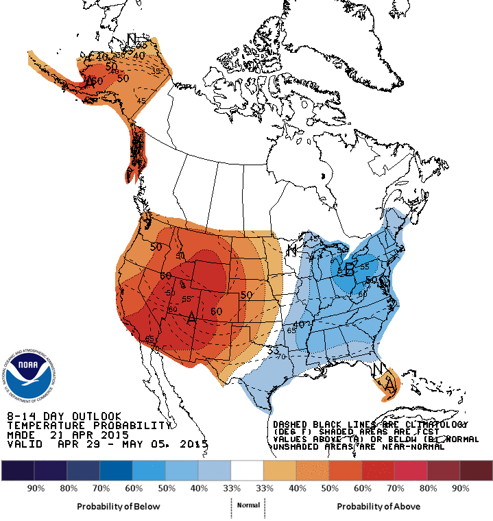
8 to 14 Day Temperature Outlook
According to NOAA's HPC, the 8 to 14 day temperature outlook (April 29th - May 5th) suggests cooler than average temperatures continuing across the Eastern U.S., but it is also showing a mild trend across the Western U.S. building into the Central U.S.
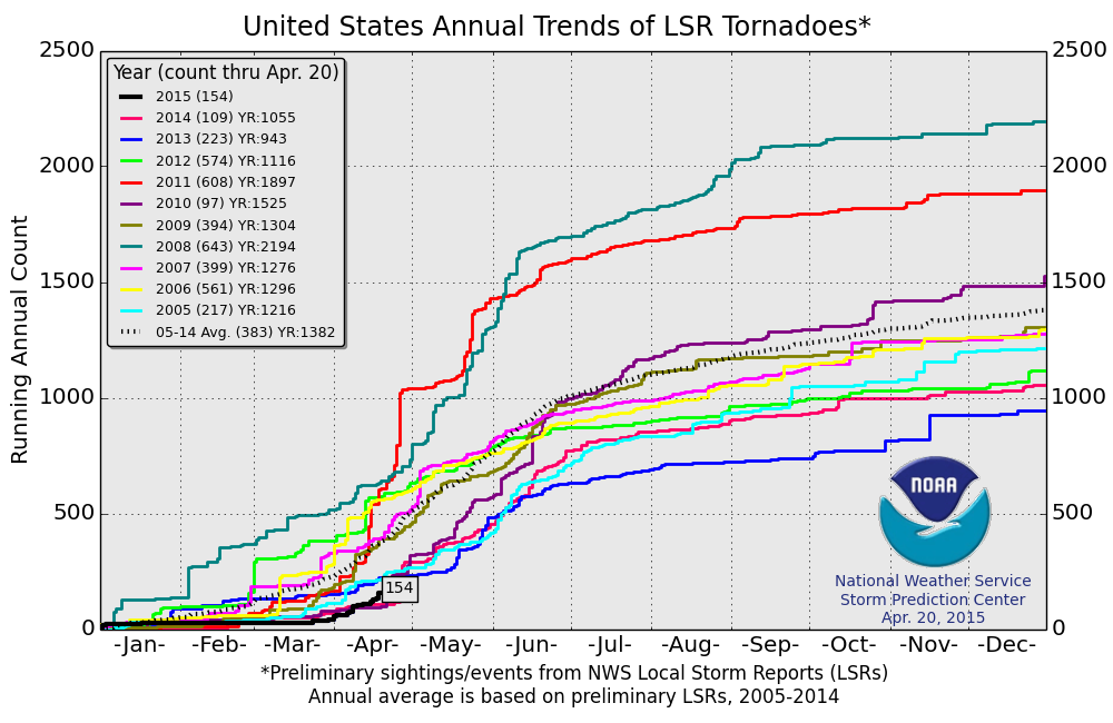
2015 PRELIMINARY Tornado Count
According to NOAA's SPC, the 2015 PRELIMINARY tornado count suggests there have been 154 tornadoes through April 20th. The 2005-2014 average through April 20th is 383, so we continue to stay well below the average to date. However, we have surpassed that of last year, when there were only 109 tornadoes through April 20th and that of 2010 when there were only 97 tornado reports.
Nearing the April 25th-28th, 2011 Tornado Outbreak
We are nearing the 4th anniversary of the largest/costliest and one of the deadliest tornado outbreaks ever recorded across the U.S., which took place April 25th-28th, 2011.
"The April 25–28, 2011 tornado outbreak was the largest and one of the deadliest tornado outbreaks ever recorded, affecting the Southern, Midwestern, and Northeastern United States and leaving catastrophic destruction in its wake. While the states that were hardest hit were Alabama and Mississippi, the outbreak also produced destructive tornadoes in Arkansas, Georgia, Tennessee and Virginia, and affected many other areas throughout the Southern and Eastern United States. In total, 355 tornadoes were confirmed by the National Weather Service (NWS) and Environment Canada in 21 states from Texas to New York to southernCanada. Widespread and destructive tornadoes occurred on each day of the outbreak, with April 27 being the most active day with a record of 211 tornadoes touching down that day from midnight to midnight CDT (0500 – 0500 UTC). Four of the tornadoes were destructive enough to be rated EF5, which is the highest ranking possible on the Enhanced Fujita scale; typically these tornadoes are only recorded about once each year or less."
"In total, 348 people were killed as a result of the outbreak, which includes 324 tornado-related deaths across six states. In addition, 24 fatalities were not caused by tornadoes, but were confirmed to be as a result of otherthunderstorm-related events such as straight-line winds, hail, flash flooding or lightning.In Alabama alone, 238 tornado-related deaths were confirmed by the Storm Prediction Center (SPC) and the state's Emergency Management Agency."
"April 27 had the most tornado-related fatalities in the United States in a single day since the "Tri-State" outbreak on March 18, 1925, when at least 747 people were killed. Nearly 500 preliminary local storm reports were received for tornadoes over four days, including 292 in 16 states on April 27 alone. This event was the costliest tornado outbreak and one of the costliest natural disasters in United States history (even after adjustments for inflation), with total damages of approximately $11 billion (2011 USD)."
Read more from Wikipedia HERE:
Below Normal 2015 Atlantic Hurricane Season Ahead?
Earlier this month, Colorado State University released it's 2015 Atlantic Hurricane Season forecast and this is what they are saying.
"Colorado State University team predicts below-average 2015 Atlantic hurricane season"
"FORT COLLINS - Colorado State University researchers are predicting a well below-average hurricane season for the Atlantic basin in 2015, citing the likely development of a moderate to strong El Niño event as well as anomalous cooling of the tropical and sub-tropical Atlantic."
"The CSU Tropical Meteorology Project team is calling for seven named storms during the Atlantic hurricane season, which runs from June 1 to Nov. 30. Of those, researchers expect three to become hurricanes and one to reach major hurricane strength (Saffir/Simpson category 3-4-5) with sustained winds of 111 miles per hour or greater."
"The team bases its forecasts on over 60 years of historical data that include Atlantic sea surface temperatures, sea level pressures, vertical wind shear levels (the change in wind direction and speed with height in the atmosphere), El Niño (warming of waters in the central and eastern tropical Pacific), and other factors."
"So far, the 2015 season is exhibiting characteristics similar to the 1957, 1987, 1991, 1993 and 2014 hurricane seasons, all of which had below-normal activity, said Phil Klotzbach, lead author of the report."
"“The tropical Atlantic has anomalously cooled over the past several months, and the chances of a moderate to strong El Niño event this summer and fall appear to be quite high,” Klotzbach said. “Historical data indicate fewer storms form in these conditions.”"
"The team predicts that 2015 tropical cyclone activity will be about 45 percent of the average season. By comparison, 2014’s tropical cyclone activity was about 75 percent of average."
"The CSU team will issue forecast updates on June 1, July 1 and Aug. 3."
EXTENDED RANGE ATLANTIC BASIN HURRICANE FORECAST FOR 2015:
-Released April 9, 2015-
Tropical Cyclone Parameters Extended Range
(1981-2010 Climatological Median Forecast for 2015
in parentheses)
Named Storms (12) 7
Named Storm Days (60.1) 30
Hurricanes (6.5) 3
Hurricane Days (21.3) 10
Major Hurricanes (2.0) 1
Major Hurricane Days (3.9) 0.5
Accumulated Cyclone Energy (92) 40
Net Tropical Cyclone Activity (103%) 45
See more from ColoState.edu HERE:
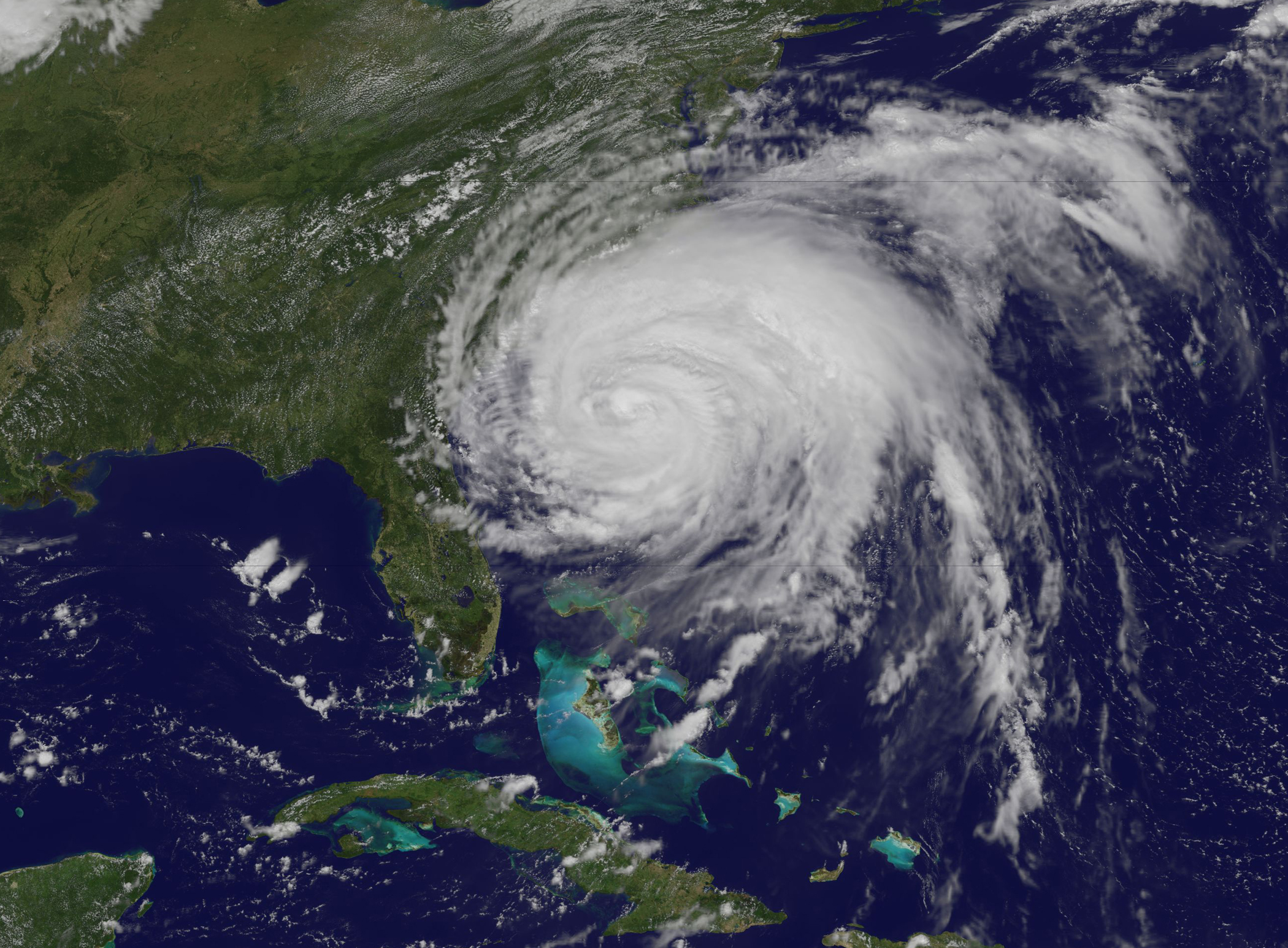
(Image courtesy: NASA; Hurricane Irene August 25, 2011)
April 23rd: National Take Our Daughters and Sons to Work Day
"Founded by Gloria Steinem and the Ms. Foundation for Women, National Take Our Daughter and Sons to Work Day, an “unofficial” National holiday began in 1993. As is it scheduled on a school day for most children, schools are provided with literature and they are encouraged to promote the program."
"National Take Our Daughters and Sons to Work Day is recognized on the fourth Thursday of April each year."
"This annual event is an educational program in the United States and Canada that revolves around parents taking their children to work with them for one day. It is the successor of Take Our Daughters to Work Day which, in 2003, was expanded to include boys. Most companies allowed both girls and boys to participate since the beginning, renaming the day “Take Our Children to Work Day” or such an equivalent name."
Read more from NationalDayCalendar.com HERE:
(Image courtesy: NationalDayCalendary.com)

"What is the Smell of Rain?"
"Australia’s national science agency – the CSIRO – has come up with some pretty amazing inventions over the past 86 years of research, from polymer banknotes to insect repellent and the world-changing Wi-Fi. But we can also lay claim to something a little more esoteric – we actually invented a whole new word. And no, we’re not talking about one of these new-fangled internet words like “YOLO”, “selfie” or “totes”."
"The word is “petrichor,” and it’s used to describe the distinct scent of rain in the air. Or, to be more precise, it’s the name of an oil that’s released from the Earth into the air before rain begins to fall."
"This heady smell of oncoming wet weather is something most people are familiar with – in fact, some scientists now suggest that humans inherited an affection for the smell from ancestors who relied on rainy weather for their survival."
Read more from EarthSky.org HERE:
(image courtesy: Bidgee via wikipedia)
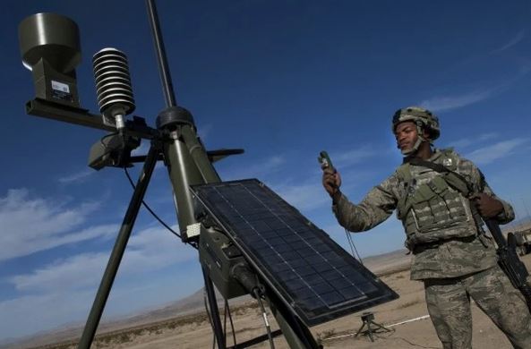
"Air Force’s plan to drop U.S. forecast system for U.K. model draws criticism"
"The U.S. Air Force Weather Agency, which provides forecasts for Air Force and Army missions around the world, plans to replace its U.S.-based forecasting system with a model from the United Kingdom."
"The U.K. model selected by the Air Force, known as the Unified Model of the United Kingdom Met Office, is widely respected. The Air Force says it will improve its forecast capabilities and lower its costs. Within a single framework, this model is able to provide both short- and longer-range forecasts over large and small areas — which is not a seamless operation within the current U.S. system."
"But the decision — which was made without coordination with the National Weather Service or U.S. Navy, who partner with the Air Force to improve predictions — has drawn criticism from parts of the U.S. weather research and forecasting community. Several leading figures say they are perplexed that the Air Force has selected a foreign model when the United States is investing substantial resources to develop its own world-class models."
Read more from WashingtonPost.com HERE:
(Image courtesy: Val Gempis/U.S. Air Force)
Thanks for chekcing in and have a great rest of your week! Don't forget to follow me on Twitter @TNelsonWX

No comments:
Post a Comment