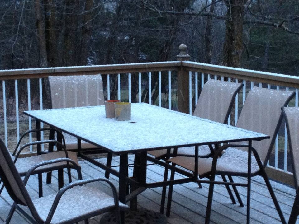
Thanks to my good friend, Amy Rutledge, from Duluth, MN for the picture below... I gather from seeing/reading numerous social media posts from friends and family memebers, that scenes like this aren't welcome anymore this late in the season.
Gradual Improvement
By Todd Nelson
If you did a double take while looking out the window yesterday... yes, that was snow! Let me remind you that Minneapolis averages nearly 2.5" of snow during the month of April, St. Cloud averages 3", International Falls average 6.5" and Duluth averages nearly 7". With that said, it's not all that uncommon to see snow in April! Hey, last April, Minneapolis saw 7", April 2013 we had nearly 18" and April 2012 we had nearly 10"! So in all reality, we're not doing too bad this year!
The good news is that this stubborn, slow moving upper level low will finally start loosening its grip over the Upper Mississippi Valley through the end of the week. Slowly, but surely we'll have gradual improvements. Today, we'll see a little more sunshine, but the winds will still be breezy. The sun will be more prominent through the end of the week along with lighter winds! Hints of April return by early next week with temperatures rebounding back into the 60s. Extended model runs suggest 70s roaring back by the early part of May with chances of thundery downpours!
We're getting closer to summer... Be patient, it's coming! But don't blink because it'll be gone.
Happy Earth Day!
=================
TUESDAY NIGHT: Mostly cloudy, a little clearing. windy and cool. Low: 31. Winds: NW: 15-30mph
WEDNESDAY: Mix of clouds and sun. Still breezy. High: 51. Winds: NW 15-30mph
WEDNESDAY NIGHT: Mostly clear and chilly! Low: 30. Winds: NW 5-15mph
THURSDAY: Frosty start. Sunny, less wind. High: 51. Winds: NW 5-10mph
FRIDAY: Increasing clouds. Rain late south? Wake-up: 31 High: 53
SATURDAY: Still below average for April. Wake-up: 36. High: 55.
SUNDAY: Closer to average. Rain develops later. Wake-up: 40. High: 58.
MONDAY: Soggy start, better later. Wake-up: 43. High: 60.
TUESDAY: Breezy. Back to April weather. Wake-up: 44. High: 63.
===================
This Day in Weather History
April 22nd
1874: Cold outbreak across Minnesota. The low at the Twin Cities was 23 degrees.
===================
Average High/Low for Minneapolis
April 22nd
Average High: 61F (Record: 90F set in 1980)
Average Low: 40F (Record: 23 set in 1874)
===================
Sunrise/Sunset Times for Minneapolis
April 22nd
Sunrise: 6:16am
Sunset: 8:07pm
==================
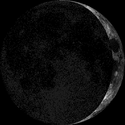
Moon Phase for April 22nd at Midnight
2.7 Days Before First Quarter
==================
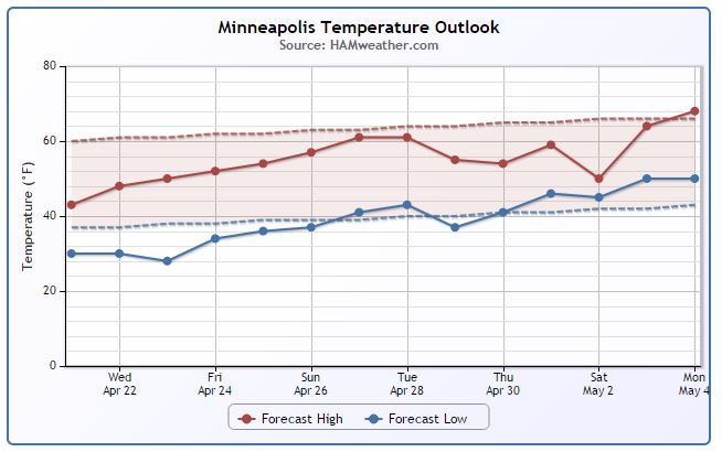
Minneapolis Temperature Trend
It's been a little hard to get used to the March-like temperatures as of late, especially after such a mild start to April. The extended forecast through the rest of the week keeps us cooler than average, but note the gradual warming trend as we head into the end of the month/early May. Extended forecasts suggest 70s returning by the first few days of May!
==================
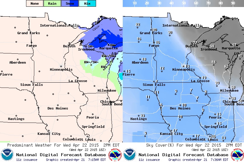
Wednesday Temperature Outlook
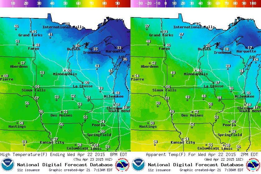
It'll be another cool and breezy day across the region. Temperatures will still be running nearly 10F to 15F cooler than average, but with the nagging winds, it'll feel nearly 15F to 20F cooler than average! That that feels like temperatures (image on right) across the northern part of the state will be in the 20s!
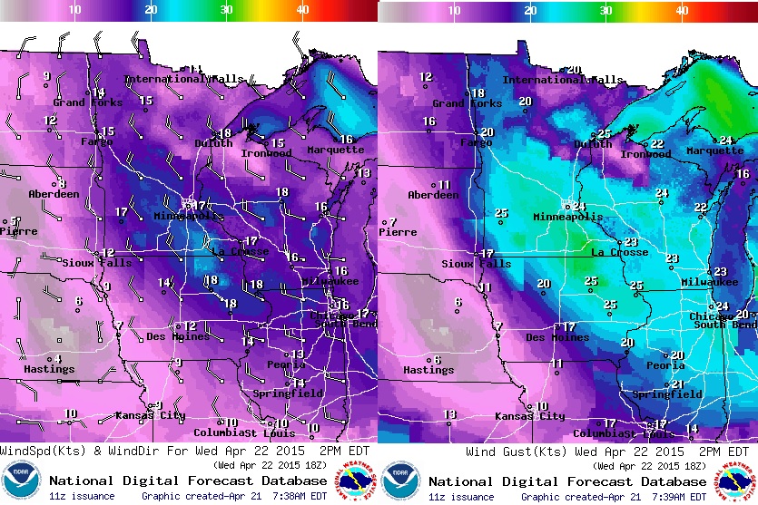
Wednesday Wind Outlook
Winds will still be quite gusty through the day Wednesday. WNW winds will be anywhere from 15mph to 25mph with gusts up to 30mph at times... I am starting to get sick of this cold and windy weather, how about you?
Wednesday Weather Outlook
The good news is that there appears to be more sunshine across the Upper Mississippi Valley on Wednesday. Sure, it'll still be breezy and cooler than average on Wednesday, but we should be able to sneak out a little more sunshine across the state. The center of low pressure will track a little farther east and allow the cloud line to shift a little farther east as well. We will continue to slowly see this gradual improvement through the rest of the week! More sun, less wind and slightly warmer temps.
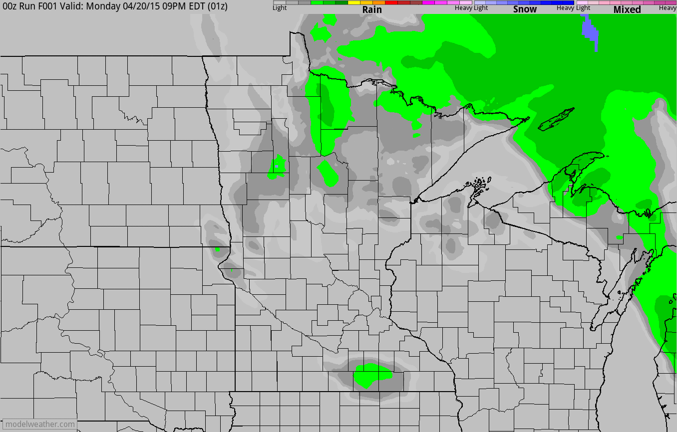
Simulated Radar
The simulated radar from PM Monday through AM Thursday shows the edge of the precipitation slowly working east. Scattered light rain/snow showers will still be possible into Wednesday, but the bulk of the precipitation will continue sliding east ever so slowly...
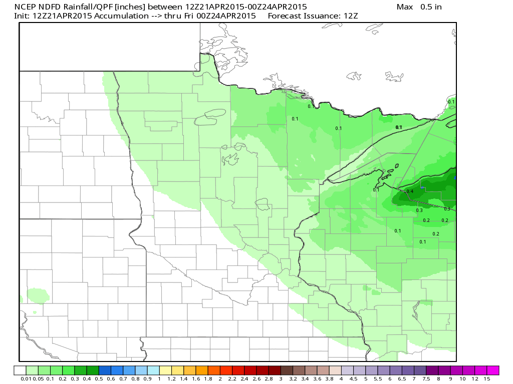
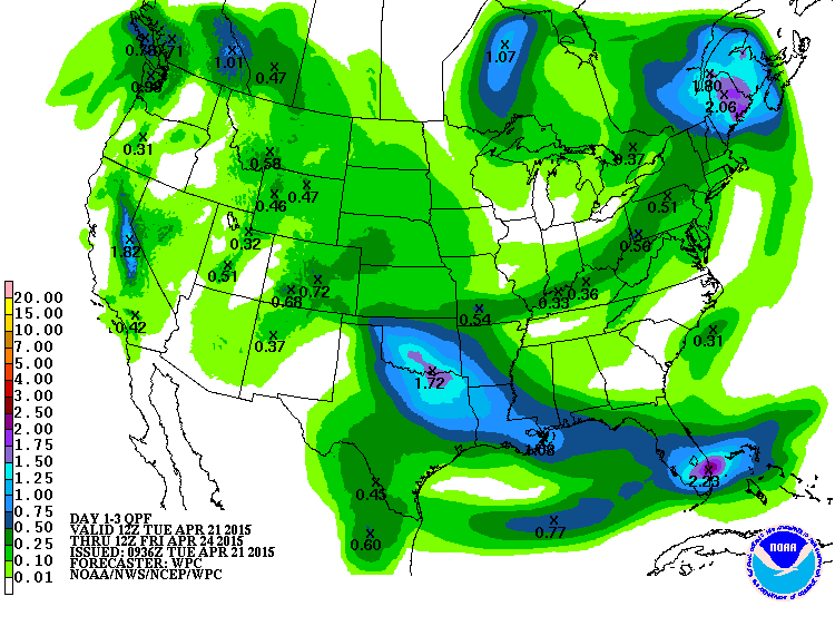
Precipitation Outlook
Additional precipitation across the region from AM Wednesday through PM Thursday suggests very limited amounts of additional precipitation across the state. The best potential will be across the Arrowhead, while the heaviest appears to be moving into the Central Great Lakes Region through the end of the week.
Image courtesy WeatherBell
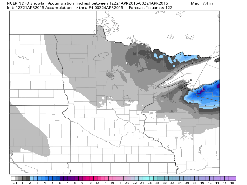
Snowfall Potential
Any additional snowfall potential will be limited to mainly PM Tuesday/AM Wednesday across the Arrowhead of Minnesota, while a few inches of slush will still be possible across parts of northern Wisconsin and the U.P. of Michigan.
Image courtesy: WeatherBell
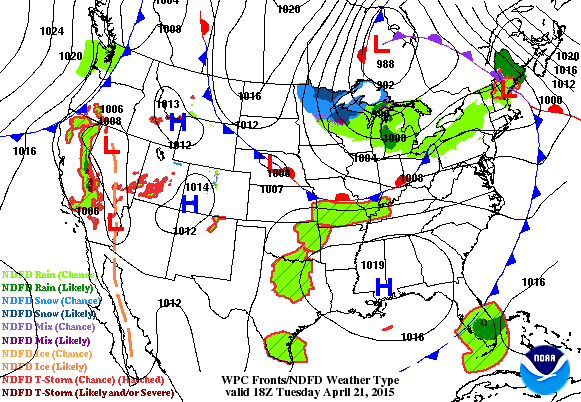
National Weather Outlook
The loop below shows the remnants wrap-around moisture across the Great Lakes Region through AM Thursday. The good news is that the stubborn and slow moving storm system will slowly loosen it's grip on the Upper Midwest as we ease towards the end of the week. The next area of interest will be across the Western U.S. and the southern tier of the nation as another impulse of energy begins working east. It appears that strong to severe thunderstorms will once again start popping across parts of the Plains/Lower Mississippi Valley over the next several days.
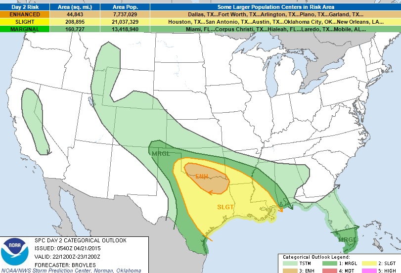
Severe Threat Wednesday
...SUMMARY... THUNDERSTORMS WITH WIND DAMAGE...LARGE HAIL AND POSSIBLY A FEW TORNADOES ARE EXPECTED TO DEVELOP FROM THE SOUTHERN PLAINS SOUTHEASTWARD ACROSS THE ARKLATEX AND INTO THE LOWER MISSISSIPPI VALLEY. OTHER STORMS WITH HAIL AND WIND DAMAGE MAY DEVELOP IN CENTRAL TEXAS AND THE TEXAS COASTAL PLAINS. MARGINALLY SEVERE THUNDERSTORMS MAY DEVELOP ACROSS PARTS OF THE SOUTHERN HIGH PLAINS AND IN SOUTH TEXAS. THUNDERSTORM DEVELOPMENT MAY ALSO OCCUR ACROSS PARTS OF THE CENTRAL TO NORTHERN ROCKIES AND SIERRA NEVADA. ...SRN PLAINS/ARKLATEX/LOWER MS VALLEY... AN UPPER-LEVEL RIDGE IS FORECAST TO BUILD NNWWD ACROSS THE SRN HIGH PLAINS INTO THE CNTRL ROCKIES ON WEDNESDAY. AT THE SFC...A LOW IS FORECAST TO DEEPEN IN NE NM WITH A WARM FRONT EXTENDING EWD ACROSS SCNTRL OK INTO CNTRL AR. SOUTH OF THE BOUNDARY...SFC DEWPOINTS SHOULD BE IN THE LOWER TO MID 60S F ACROSS NORTH TX AND SRN OK WHERE MODERATE INSTABILITY SHOULD BE IN PLACE BY AFTERNOON. CONVECTION APPEARS LIKELY TO INITIATE BY LATE AFTERNOON ALONG THE WARM FRONT IN SW OK WITH AN MCS ORGANIZING AND MOVING ESEWD ACROSS SRN OK INTO NE TX. THERE IS STILL SOME QUESTION ABOUT TIMING BUT THE GFS SOLUTION SEEMS TO BE REASONABLE WITH A LATE AFTERNOON AND EARLY EVENING MCS. NAM FORECAST SOUNDINGS FOR 00Z/THU AT FREDERICK OK AND VERNON TX SHOW 1500 TO 2000 J/KG OF MLCAPE WITH VERY STEEP MID-LEVEL LAPSE RATES APPROACHING 9.0 C/KM. IN ADDITION...AN IMPRESSIVE WIND-SHEAR ENVIRONMENT IS FORECAST WITH SUBSTANTIAL VEERING WITH HEIGHT BELOW 850 AND 0-6 KM SHEAR NEAR 60 KT. THIS WOULD FAVOR THE DEVELOPMENT OF SUPERCELLS WITH LARGE HAIL AND WIND DAMAGE EARLY IN THE EVENT. HAILSTONES OF GREATER THAN 2 INCHES IN DIAMETER WILL BE POSSIBLE WITH THE MORE DOMINANT CELLS. A FEW TORNADOES MAY OCCUR ESPECIALLY WITH PERSISTENT ROTATING STORMS. A RELATIVELY FAST-MOVING MCS MAY DEVELOP A LINEAR STRUCTURE AND COLD POOL EARLY WEDNESDAY EVENING WHICH COULD RESULT IN AN ENHANCED WIND-DAMAGE THREAT. THE SEVERE THREAT FROM THIS CONVECTIVE SYSTEM COULD EXTEND AS FAR SOUTHEAST AS EAST TX AND NW LA DURING THE EVENING AND POSSIBLY DURING THE EARLY OVERNIGHT OVER PARTS OF THE LOWER MS VALLEY. ...TX HILL COUNTRY/TX COASTAL PLAINS... AN UPPER-LEVEL RIDGE IS FORECAST TO BE MAINTAINED ACROSS THE TX HILL COUNTRY AND SRN HIGH PLAINS ON WEDNESDAY AS A WARM SECTOR REMAINS LOCATED OVER MUCH OF THE SRN TWO-THIRDS OF TX. THE AIRMASS ACROSS THE TX HILL COUNTRY AND THE TX COASTAL PLAINS...AWAY FROM THE IMMEDIATE COAST...IS FORECAST TO BECOME MODERATELY TO STRONGLY UNSTABLE BY WEDNESDAY AFTERNOON. FORECAST SOUNDINGS FOR 00Z/THU AT AUSTIN AND COLLEGE STATION SHOW MLCAPE ABOVE 3000 J/KG WITH LOWER 70S F DEWPOINTS. IN ADDITION TO THE IMPRESSIVE THERMODYNAMICS...DEEP-LAYER SHEAR SHOULD BE IN THE 50 TO 60 KT RANGE. THIS SHOULD SUPPORT SEVERE THUNDERSTORM DEVELOPMENT WITH SUPERCELLS THE FAVORED STORM MODE. CONVECTIVE COVERAGE IS THE MAIN UNCERTAINTY WITH THE UPPER-LEVEL RIDGE TO THE WEST. EVEN THOUGH STORM DEVELOPMENT SHOULD REMAIN ISOLATED...SUPERCELLS SHOULD BE CAPABLE OF PRODUCING LARGE HAIL...WIND DAMAGE AND POSSIBLY A TORNADO. ...SRN FL... AN UPPER-LEVEL TROUGH IS FORECAST TO MOVE SLOWLY EWD ACROSS THE EAST COAST AS A BELT OF STRONGER MID-LEVEL FLOW MOVES EWD ACROSS THE NRN GULF OF MEXICO. A MOIST AIRMASS IS FORECAST ACROSS SOUTH FL WHERE MODERATE INSTABILITY SHOULD DEVELOP BY MIDDAY. CELLS THAT CAN INITIATE ACROSS SOUTH FL DURING THE EARLY AFTERNOON MAY OBTAIN A MARGINAL WIND DAMAGE THREAT DUE TO MODERATE DEEP-LAYER SHEAR AND UNIDIRECTIONAL WIND PROFILES.
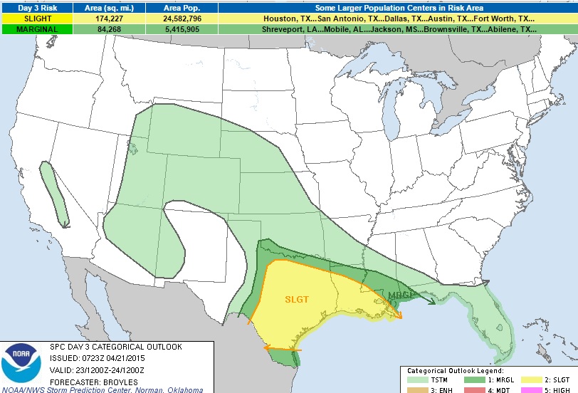
Severe Threat Thursday
...SUMMARY... ISOLATED TO SCATTERED THUNDERSTORMS...WITH SOME PRODUCING LARGE HAIL AND WIND DAMAGE...WILL BE POSSIBLE ACROSS MUCH OF TEXAS AND LOUISIANA. MARGINALLY SEVERE STORMS WITH HAIL AND STRONG WIND GUSTS MAY OCCUR IN PARTS OF THE CENTRAL GULF COAST...WEST-CENTRAL TEXAS AND NORTH TEXAS TO SOUTHERN OKLAHOMA. THUNDERSTORMS MAY ALSO DEVELOP ACROSS PARTS OF THE OZARKS...CENTRAL PLAINS...CENTRAL ROCKIES...INTERMOUNTAIN WEST AND SIERRA NEVADA. ...TX/LA... AN UPPER-LEVEL RIDGE IS FORECAST TO MOVE EWD ACROSS THE SRN PLAINS ON THURSDAY WITH A BROAD WARM SECTOR IN PLACE FROM CNTRL TX EWD INTO THE LOWER MS VALLEY. IN SPITE OF MODERATE TO STRONG INSTABILITY...THE UPPER-LEVEL RIDGE IS EXPECTED TO KEEP CONVECTIVE DEVELOPMENT ISOLATED ACROSS PARTS OF THE WARM SECTOR THURSDAY AFTERNOON. A FEW CLUSTERS OF STORMS COULD DEVELOP BUT THIS WILL BE DEPENDENT UPON MESOSCALE FACTORS THAT CAN NOT BE RESOLVED AT THIS TIME. THE MOST PROBABLE AREAS FOR SCATTERED THUNDERSTORM DEVELOPMENT WOULD BE ALONG THE INSTABILITY GRADIENT IN CNTRL AND NE TX. THUNDERSTORMS MAY ALSO INITIATE ALONG AN OUTFLOW BOUNDARY RESULTING FROM THE PREVIOUS DAYS MCS FROM NE TX SEWD INTO CNTRL LA. FORECAST SOUNDINGS FOR 00Z/FRI AT DALLAS/FORT WORTH AND WACO SHOW IMPRESSIVE THERMODYNAMICS WITH SFC DEWPOINTS IN THE LOWER 70S F AND MLCAPE NEAR 4000 J/KG. IN ADDITION...STRONG DEEP-LAYER SHEAR IS FORECAST WITH 0-6 KM SHEAR NEAR 60 KT. THIS ENVIRONMENT WOULD EASILY SUPPORT SUPERCELLS WITH LARGE HAIL...WIND DAMAGE AND POSSIBLY A TORNADO. ISOLATED VERY LARGE HAIL COULD OCCUR AS WELL. FURTHER TO THE EAST...FORECAST SOUNDINGS FOR 00Z/FRI AT MONROE LA SHOW MLCAPE NEAR 3000 J/KG AND 45 KT OF 0-6 KM SHEAR. THIS WOULD ALSO SUPPORT SUPERCELL DEVELOPMENT WITH LARGE HAIL AND WIND DAMAGE POSSIBLE.
Precipitation Outlook
According to NOAA's HPC, the 3 day precipitation outlook suggests another round of moisture moving through the Western U.S. through the end of the week. It's nice to see some of that across the high elevations of the Sierra Nevada Range, which will likely be in the form of a little snow. Several days of shower and thunderstorm activity across the Southern Plains/Lower Mississippi Valley will allow for some heavier rainfall potential there. Upwards of 1" to 2"+ may be possible by the end of the week.
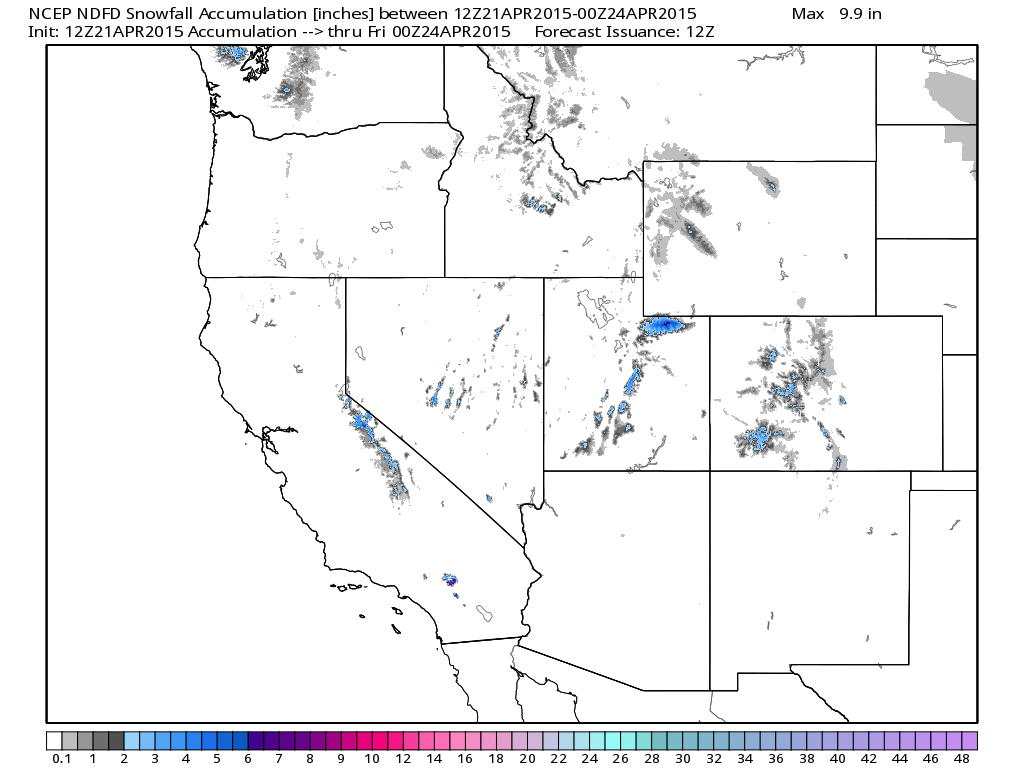
Western Snowfall
Although it doesn't appear to be much, there is still some good news for folks in the Western U.S. looking for any signs of moisture. The snowfall forecast suggests a little across the high elevations, including the Sierra Nevada Range!
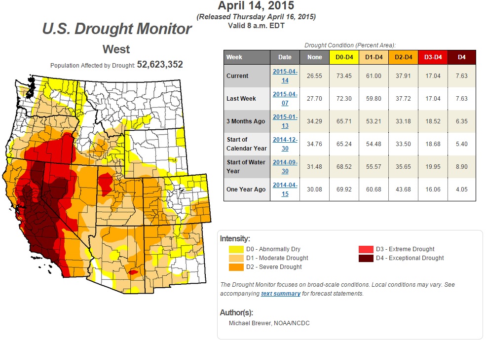
Western Drought
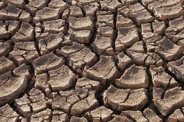
According to the U.S. Drought Monitor, we're still in a massive drought across the Western U.S.. In the view below, nearly 7.6% of the region is considered to be in the worst drought classification (EXCEPTIONAL), most of which is in California. Unfortunately, we've seen this steadily get worse over the last several years and there doesn't appear to be any major shift/improvement in sight.
"Drought is not just a California problem"
"With all the attention focused on California's water woes, an observer might conclude that the Golden State's drought is the exception. It isn't. Forty states expect to see water shortages in at least some areas in the next decade, according to a government watchdog agency."
"In a 2013 survey by the Government Accountability Office (GAO), state water managers from around the country said they expect freshwater shortages to continue into the next decade, even under what they described as "average" conditions. If those conditions change—whether because of rapid population growth, unusually low snowfall or rainfall, or accelerated economic growth—the situation could worsen."
Read more from USAToday.com HERE:
(Image Courtesy: Tomas Castelazo via Wikipedia)
Happy Earth Day 2015!
"Earth Day is an annual event, celebrated on April 22, on which day events worldwide are held to demonstrate support for environmental protection. It was first celebrated in 1970, and is now coordinated globally by the Earth Day Network and celebrated in more than 192 countries each year."
"In 1969 at a UNESCO Conference in San Francisco, peace activist John McConnell proposed a day to honor the Earth and the concept of peace, to first be celebrated on March 21, 1970, the first day of spring in the northern hemisphere. This day of nature's equipoise was later sanctioned in a Proclamation written by McConnell and signed by Secretary General U Thant at the United Nations. A month later a separate Earth Day was founded by United States Senator Gaylord Nelson as an environmental teach-in first held on April 22, 1970. Nelson was later awarded the Presidential Medal of Freedom Award in recognition of his work. While this April 22 Earth Day was focused on the United States, an organization launched by Denis Hayes, who was the original national coordinator in 1970, took it international in 1990 and organized events in 141 nations. Numerous communities celebrate Earth Week, an entire week of activities focused on environmental issues."
Read more about Earth Day from Wikipedia HERE:
Learn more about Earth Day from EarthDay.org HERE:
(Image courtesy: EarthDay.org)

Thanks for checking in and have a great rest of your week. Don't forget to follow me on Twitter @TNelsonWX

No comments:
Post a Comment