
Cutoff Low
By Todd Nelson
Boy did I get put to work on Sunday! The honey-do list was overflowing and thanks to the cool, damp weather, I couldn't use the excuse that there were outdoor chores that needed to be done.
The good news is that you can now eat off my floor! Bon appetit!
Weather conditions over the next several days will remain cool and breezy with a few spits of rain; perhaps even a few snow showers across the northern part of the state. This large upper level low is so big, that it diverted the strong upper level steering winds around it! It will be in no hurry to move this week. What you see is what you get.
The sun will become a little less scarce by the end of the week as temperatures continue to slowly recover. It'll be a little tough to get used to the late March weather considering that prior to Sunday, Minneapolis was running nearly 6F above average! We had 7 days with temperatures 70F or warmer, April 1st we hit a record 84F! According to NOAA's Climate Prediction Center, the eastern two-thirds of the country has a fairly good chance to remain below average through much of the rest of the month. Keep the light jackets handy and hopefully the rains continue!
==================
SUNDAY NIGHT: Mostly cloudy with a few lingering sprinkles/light rain showers. Low: 40. Winds: NW 10-15
MONDAY: Breezy & cooler with a rain/snow mix up north. High: 48. Winds: WNW 15-30
MONDAY NIGHT: Breezy and cool. Light rain/snow mix possible, mainly north. Low: 35. Winds: WNW 15-30
TUESDAY: Still breezy and cool. Light AM mix, then a chance of sprinkles, light rain showers. High: 49. Winds: WNW 15-30
WEDNESDAY: Mix of clouds and sun. Still breezy. Wake-up: 32. High: 48
THURSDAY: More sun, light jacket worty. Wake-up: 31. High: 48
FRIDAY: Less wind, a little warmer. Wake-up: 32 High: 53
SATURDAY: Still below average for April. Wake-up: 35. High: 54.
SUNDAY: Increasing clouds. Wake-up: 35. High: 53.
===================
This Day in Weather History
April 20th
1970: Snow fell across much of Minnesota.
===================
Average High/Low for Minneapolis
April 20th
Average High: 60F (Record: 83F set in 1980)
Average Low: 39F (Record: 21F set in 2013)
====================
Sunrise/Sunset Times for Minneapolis
April 20th
Sunrise: 6:20am
Sunset: 8:05pm
====================
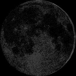
Moon Phase for April 20th at Midnight
2.5 Days Since New Moon
====================
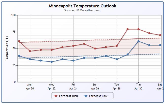
Minneapolis Temperature Trend
More March-like temps are on the way through the week ahead. Instead of seeing highs in the 60s and 70s, we'll be dealing with highs in the 40s and lower 50s. Extended forecasts keep us slightly below average through much of the end of the month.
====================
Monday Weather Outlook
The storm system that brought soggy weather to the region PM Saturday/Sunday will continue to spin over the Great Lakes on Monday. We'll be on the western edge of this large storm, which means we'll have continued windy and cool weather. Note that high temperatures will only by in the 30s and 40s across much of the state, while winds will be anywhere from 15mph-30mph.
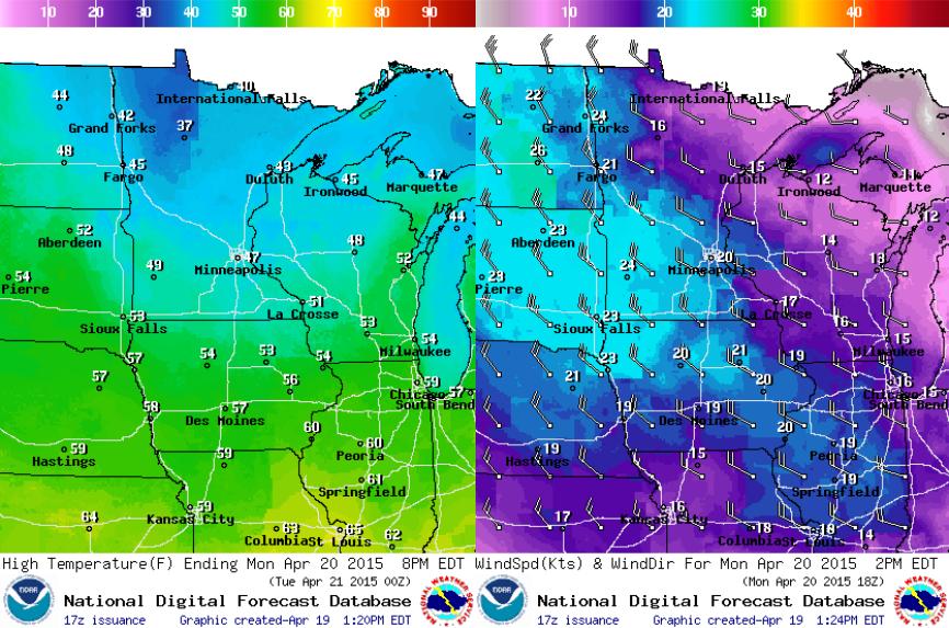
Monday Weather Continued
Low clouds will continue rotating through the region through the first half of the week with sprinkles, light rain showers and even a few light snow showers across the northern part of the state. What you see is what you're going to get over the next few days...
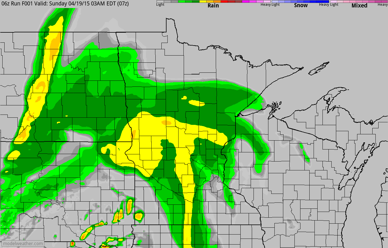
Simulated Radar
You can see the bulk of the precipitation from PM Saturday/AM Sunday slowly shift east into early this week. Note the wrap-around moisture moving in from the northwest, some of which may mix in with a little snow across the northern half of the state.
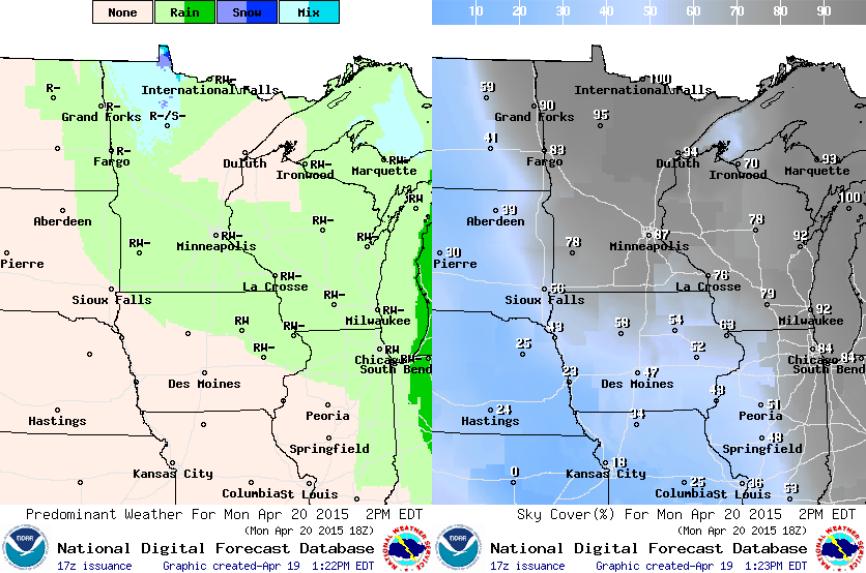
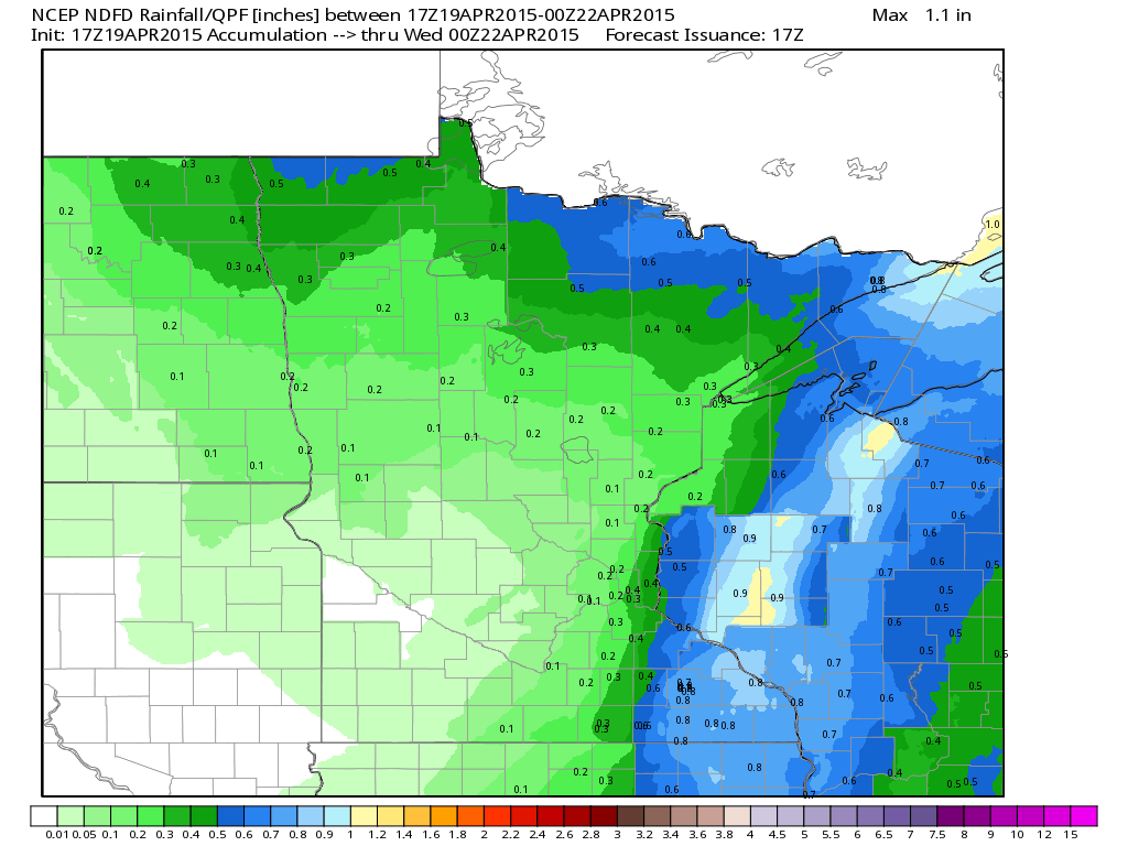
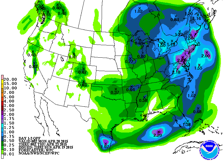
Precipitation Potential
The heaviest precipitation into early next week looks to shift into western/central Wisconsin with up to 0.50" to 1.00" possible through PM Tuesday. Also note the heavier precipitation along the international border, so of this will be in the form of snow! The Twin Cities on the other hand, looks to have fairly minimal additional precipitation through PM Tuesday.
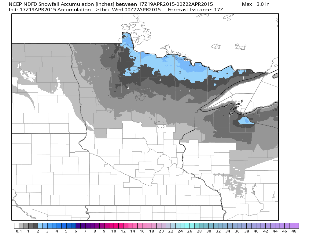
Snowfall Potential
Interestingly, we're still getting indications of some minor snowfall accumulations across the far northern reaches of the state. Up to a couple inches of slush may be possible through PM Tuesday!
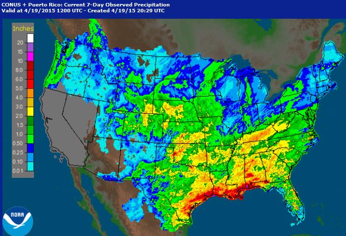
Precipitation Past 7 Days
It was a fairly active week across the middle part of the country. Numerous showers and thunderstorms helped to pump out significant rainfall tallies across the Gulf Coast States, radar estimates suggest nearly 5" to 10"+ in spots near southern Mississippi and Alabama.
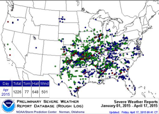
Severe Weather in April
According to NOAA's SPC, there have been nearly 1,200 reports of hail, high winds and/or tornadoes through the first 17 days of April. The Preliminary April tornado count is 77, the April average according to NOAA's NCDC is 155 through the entire month.
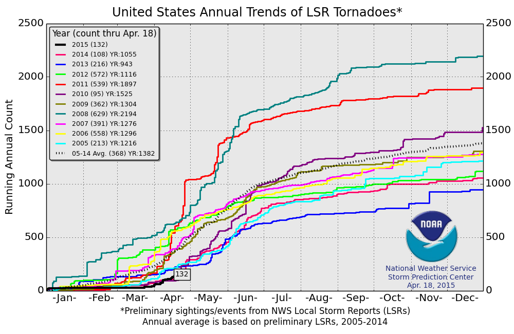
2015 PRELIMINARY Tornado Reports
It was a very quiet start to the severe weather season, but things have picked up more recently. The 2015 PRELIMINARY tornado count through April 18th is 132. The 2005-2014 average is 368 through that date, so we're less than half of our short-term average to date.
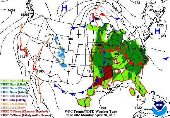
National Weather Outlook
The storm system that brought heavy rain, snow and severe weather across parts of the country will slowly lose it's steam. The bulk of the precipitation will move offshore by PM Tuesday. Another storm system will move into the western U.S. by early next week
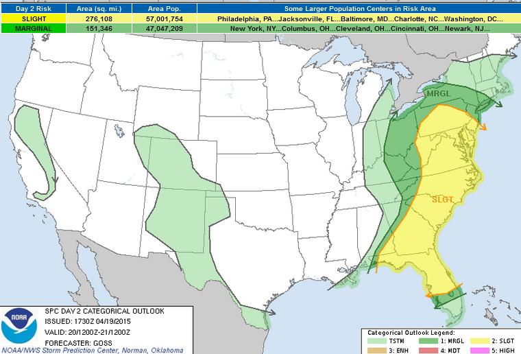
Severe Threat Monday
...SUMMARY...
SCATTERED THUNDERSTORMS WITH POTENTIAL FOR HAIL AND LOCALLY DAMAGING
WIND GUSTS WILL BE POSSIBLE ON MONDAY FROM THE CENTRAL APPALACHIAN
MOUNTAINS SOUTHWARD ACROSS THE MID ATLANTIC INTO THE CAROLINAS AND
GEORGIA/SOUTHEAST ALABAMA.
...SYNOPSIS...
WHILE RIDGING PREVAILS OVER MUCH OF THE W...A LARGE UPPER TROUGH
ENCOMPASSING MUCH OF THE CENTRAL AND ERN U.S. WILL CONTINUE A VERY
GRADUAL EWD ADVANCE ON MON. AT THE SURFACE...A DEEP LOW WILL DRIFT
NWD ACROSS THE UPPER GREAT LAKES REGION INTO ONTARIO...WHILE A
TRAILING COLD FRONT SWEEPS EWD ACROSS THE APPALACHIANS THROUGH
MIDDAY...AND THEN THE ATLANTIC AND GULF COASTAL STATES THROUGH THE
REMAINDER OF THE PERIOD.
...PA/NJ/SRN NY/ERN OH VICINITY SWD ACROSS GA...
SHOWER/STORM DEVELOPMENT IS FORECAST TO INCREASE STEADILY THROUGH
THE LATE MORNING AND INTO THE AFTERNOON HOURS ACROSS THE UPPER OH
VALLEY/APPALACHIANS REGION AHEAD OF THE ADVANCING COLD FRONT...WITH
ISOLATED STORMS LIKELY TO BECOME LOCALLY SEVERE BY AFTERNOON. THE
PRIMARY RISK -- IN THE FORM OF LOCALLY DAMAGING WINDS AND HAIL --
SHOULD EXTEND FROM PA/WV SWD ACROSS THE ATLANTIC COAST STATES E OF
THE APPALACHIAN CREST...WHERE AFTERNOON DESTABILIZATION SHOULD
SUPPORT MIXED-LAYER CAPE VALUES AVERAGING AROUND 1000 J/KG AHEAD OF
THE FRONT. WITH A BROAD AREA OF STRONG CYCLONIC FLOW ALOFT AHEAD OF
THE MAIN UPPER SYSTEM SPREADING ACROSS THE WARM SECTOR...SUFFICIENT
SHEAR WILL EXIST ACROSS THIS LARGE REGION TO SUPPORT LOCALLY INTENSE
STORMS. WITH THAT SAID...ANY CONCENTRATED AREAS OF RISK ARE NOT
APPARENT ATTM...AND THUS WILL MAINTAIN THE LARGE 15%/SLIGHT RISK
AREA ACROSS THE ENTIRE REGION.
...FL...
MODELS -- BOTH OPERATIONAL AND HI-RES CAMS -- ARE CONSISTENT IN
DEPICTING A LARGE AREA OF GULF OF MEXICO CONVECTION MOVING EWD
TOWARD FL AT THE START OF THE PERIOD...IN ASSOCIATION WITH A WEAK
MID-LEVEL VORT MAX. WHILE TIMING DIFFERS ON THE ARRIVAL OF THIS
CONVECTIVE CLUSTER...SEVERE RISK COULD ACCOMPANY THE PASSAGE OF
CONVECTION ACROSS THE PENINSULA IF SOME DIURNAL
HEATING/DESTABILIZATION CAN OCCUR IN ADVANCE. PRESUMING THIS
OCCURS...MODERATELY STRONG FLOW FIELD ALOFT WOULD SUPPORT
ORGANIZATION POTENTIAL -- AND ASSOCIATED RISK FOR HAIL AND/OR
DAMAGING GUSTS. WHILE MOST CONVECTION SHOULD MOVE OFFSHORE DURING
THE AFTERNOON...ADDITIONAL SEVERE RISK COULD EVOLVE LATER IN THE
AFTERNOON/EVENING -- PARTICULARLY ACROSS THE FL PANHANDLE AND NRN FL
-- WITH A SECOND ROUND OF STORMS ALONG THE ADVANCING COLD FRONT.
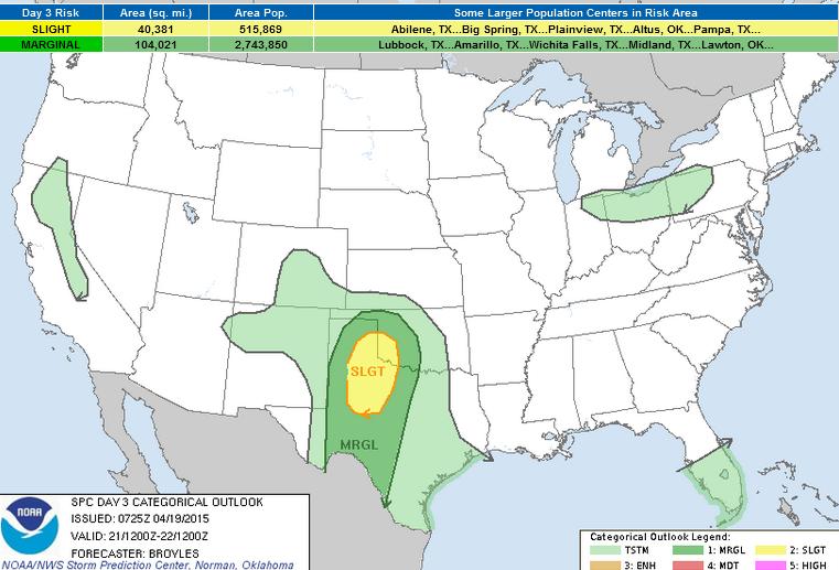
Severe Threat Tuesday
...SUMMARY...
THUNDERSTORM DEVELOPMENT IS EXPECTED TO TAKE PLACE LATE TUESDAY
AFTERNOON ACROSS THE SOUTHERN PLAINS WHERE LARGE HAIL AND WIND
DAMAGE WILL BE POSSIBLE. THUNDERSTORMS MAY ALSO FORM OVER PARTS OF
THE SOUTHERN AND CENTRAL ROCKIES...SOUTHERN GREAT
LAKES...SOUTH-CENTRAL FLORIDA PENINSULA AND IN THE SIERRA NEVADA.
...SRN PLAINS...
A BROAD CYCLONIC FLOW PATTERN IS FORECAST ACROSS THE ERN HALF OF THE
NATION ON TUESDAY AS AN UPPER-LEVEL RIDGE MOVES SLOWLY ACROSS THE
SRN ROCKIES AND GREAT BASIN. AT THE SFC...A LOW IS FORECAST TO MOVE
EWD INTO THE SRN HIGH PLAINS WITH A DRYLINE SETTING UP ACROSS WEST
TX. SLY LOW-LEVEL WINDS TO THE EAST OF THE DRYLINE SHOULD RESULT IN
MOISTURE ADVECTION THROUGHOUT THE PERIOD. MODEL SOLUTIONS VARY ON
HOW MUCH MOISTURE WILL RETURN NWD. THE NAM AND GFS SOLUTIONS SUGGEST
THAT SFC DEWPOINTS WILL REACH THE LOWER 60S F IN THE TX HILL COUNTRY
AND WEST TX WITH MID TO UPPER 50S F POSSIBLY IN THE LOW ROLLING
PLAINS AND ON THE CAPROCK. BOTH THE NAM AND GFS SOLUTIONS DEVELOP
CONVECTION ALONG AN AXIS OF INSTABILITY FROM THE ERN TX PANHANDLE
SEWD INTO NW TX LATE TUESDAY AFTERNOON. GFS FORECAST SOUNDINGS AT
00Z/WEDNESDAY SHOW POCKETS OF MODERATE INSTABILITY IN PLACE WITH
ABOUT 40 KT OF DEEP-LAYER SHEAR OWING TO DIRECTIONAL SHEAR BELOW 700
MB AND 50 KT OF FLOW ALOFT. THIS COMBINED WITH STEEP LAPSE RATES
WOULD SUPPORT SUPERCELLS WITH LARGE HAIL. ISOLATED WIND DAMAGE WOULD
ALSO BE POSSIBLE. ALTHOUGH THE MODELS ARE SOMEWHAT IN AGREEMENT
CONCERNING CONVECTIVE INITIATION ON THE CAPROCK AND OVER THE LOW
ROLLING PLAINS...THE EXTENDED FORECAST RANGE INTRODUCES MUCH
UNCERTAINTY. THE UPPER-LEVEL RIDGE COULD HELP TO INHIBIT STORM
DEVELOPMENT KEEPING CONVECTIVE COVERAGE ISOLATED ACROSS THE REGION.
ATTM...WILL INTRODUCE A SMALL SLIGHT RISK AREA ACROSS PARTS OF NW
TX...THE SE TX PANHANDLE AND SW OK WHERE THE POTENTIAL FOR SEVERE
STORMS APPEARS THE GREATEST.
Precipitation Outlook
As the storm system continue to push east, the heaviest precipitation will push into parts of the Northeast through the early week time frame. Thunderstorm activity will help to produce as much as 1" to 2"+ in some areas! Note the precipitation moving into parts of the West Coast! While this is much needed, it's not very widespread the the heaviest will be found across the higher elevation of the Sierra Nevada Range.
Thanks for checking in and have a great week ahead! Don't forget to follow me on Twitter @TNelsonWX

No comments:
Post a Comment