WOW! The St. Michael/Albertville community has been nominated as one of the TOP 4 FINALISTS in Kraft Hockeyville's Grandprize: $150,000 for rink upgrades and chance to host an NHL pre-season hockey game!! They need your help in the voting process!
Voting Starts: MON, APRIL 20 AT 11:00PM CST
Voting Ends: WED, APRIL 22 AT 10:59PM CST
Learn more at VoteSTMA.com HERE:
Learn more about the Kraft Hockeyville HERE:

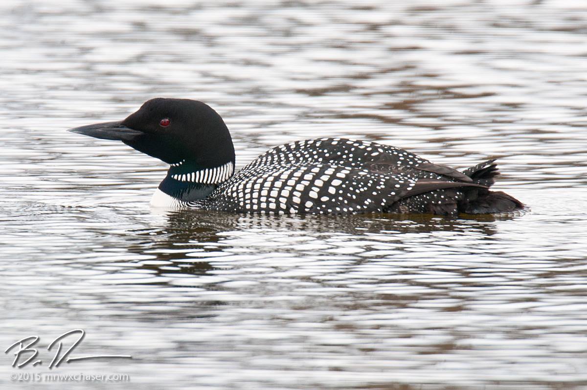
The Common Loon Returns...
Thanks to my good friend, Bill Doms, for the picture below. He snapped a wonderful picture of this loon on an area lake over the weekend. Interestingly, Loons "travel from their winter home along the Atlantic coast from North Carolina south to Florida, or on the Gulf of Mexico."
Read more about the Common Loon from the MN DNR HERE:
See more of Bill Doms' great pictures at his website www.mnwxchaser.com HERE:
Feels Like Fall
By Todd Nelson
This cold and windy weather makes me want to drag out the crockpot again. I feel like warm, hearty meals help take the edge off the cool, cloudy, windy weather. Interestingly, I haven't had an urge like this since last Fall when the leaves were falling off the trees, now they're showing up on trees again.
A large area of low pressure continues to spin north of the Great Lakes Region. Due to it's stationary nature, it will continue to funnel down cooler Canadian air, which will be nearly 10F to 15F cooler than normal for this time of the year. There may even be some light, slushy snow accumulations across the far northern part of the state through Wednesday!
Weather conditions will slowly improve through the week, with gradually more sunshine and winds subsiding, finally, by the end of the week. Although we'll still be a little cooler than average by the week's end/weekend, at least we'll be a little closer to normal.
Extended model runs suggest temperatures getting back to above average by the end of the month with chances of thunderstorms returning! MSP is ~1.75" below average precip since Jan. 1st; 92% of MN is in Moderate Drought! We need rain!
===============
MONDAY NIGHT: Windy and cool. Light rain/snow mix possible, mainly north. Low: 33. Winds: WNW 15-35mph
TUESDAY: Light rain/snow mix possible early, mainly north, then changing to sprinkles/light rain showers. Still windy and cool. High: 46. Winds: WNW 15-30
TUESDAY NIGHT: Mostly cloudy, windy and cool. Low: 31. Winds: NW: 15-30mph
WEDNESDAY: Mix of clouds and sun. Still breezy. High: 48. Winds: NW 15-30mph
THURSDAY: More sun, light jacket worthy. Wake-up: 30. High: 49
FRIDAY: Less wind, a little warmer. Wake-up: 31 High: 52
SATURDAY: Still below average for April. Wake-up: 34. High: 53.
SUNDAY: Nothing rough. Wake-up: 35. High: 54.
MONDAY: Still cool for April. Wake-up: 36. High: 56.
=================
This Day in Weather History
April 21st
1910: Snowstorm hits northeastern Minnesota. Duluth picks up 6.5 inches.
==================
Average High/Low for Minneapolis
April 21st
Average High: 61F (Record: 95F set in 1980)
Average Low: 40F (Record: 22F set in 1966)
==================
Sunrise/Sunset Times for Minneapolis
April 21st
Sunrise: 6:18am
Sunset: 8:06pm
==================
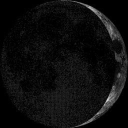
Moon Phase for April 21st at Midnight
3.5 Days Since New Moon
=====================
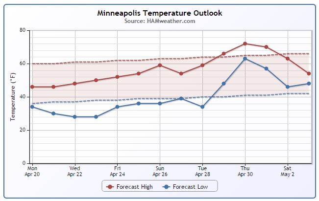
Minneapolis Temperature Trend
Cool, windy weather will continue through the week ahead. Temperatures will actually be running nearly 10F to 20F below average through the week ahead! We'll see a gradual warming trend by the weekend with reading finally back to near/above average levels by the end of the month.
====================
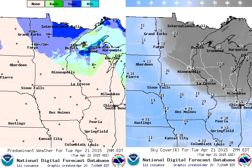
Tuesday Weather Outlook
We'll still be under the influence of the large upper level low spinning near the Great Lakes Region on Tuesday. Note the large wind field, stretching from the Red River Valley into the Ohio Valley. Winds in this particular zone could once again be 20mph to 40mph+. With temperatures in the 30s and 40s across much of the state, it'll be reminiscent of a Fall day.

Tuesday Weather Outlook
Wrap around moisture will continue into Tuesday and with temperatures near freezing, some of the moisture will be in the form on snow! I could see minor accumulations possible across the extreme northern part of the state through midweek.
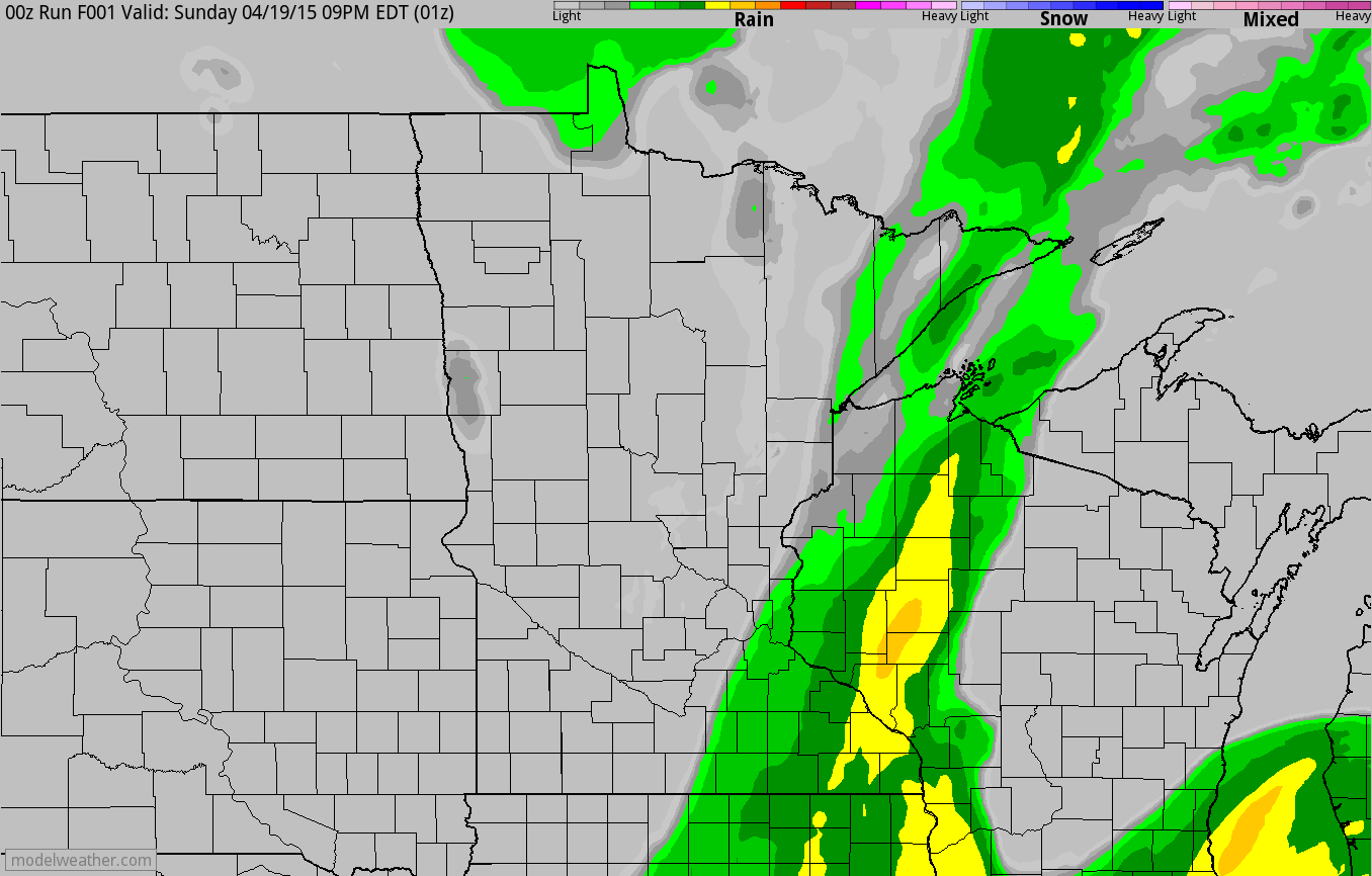
Simulated Radar
The bulk of the precipitation has moved off to the east, but wrap around moisture will continue through midweek. Any additional precipitation should remain light and stay confined to mainly the northern part of the state. Also note the blue mixing in AM Tuesday - AM Wednesday!
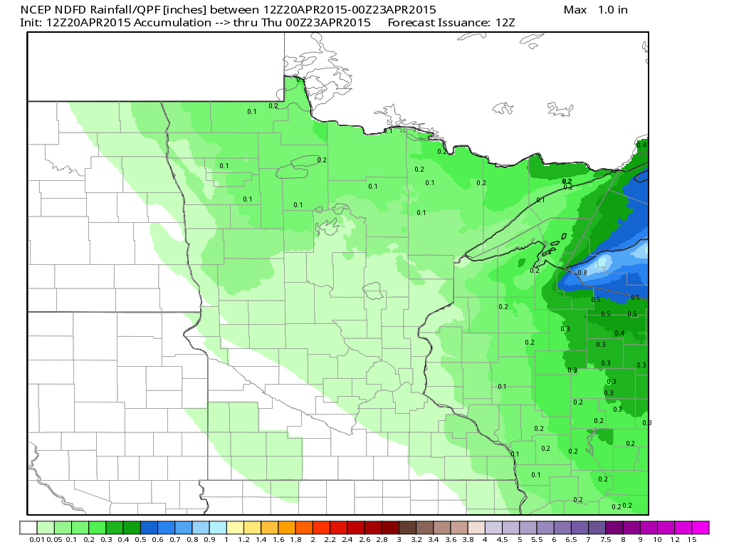
Precipitation Outlook
The
precipitation outlook through PM Wednesday doesn't look all that
impressive, but up to 0.1" to 0.2" may be possible along the
international border.
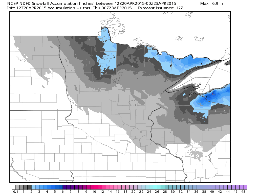
Snowfall Potential
We're
still getting indications that up to a couple/few inches of slushy snow
may accumulation near the international border through PM Wednesday.
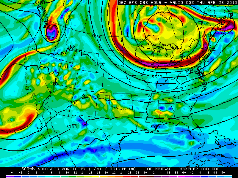
Upper Level Low
Take
a look at the 500mb vorticity (spin) map below. Note the big ball over
the Great Lakes Region/Ontario... that's our current weather maker
causing all the cool/windy weather close to home. Unfortunately, it will
be in no hurry to move out of there as it has diverted the upper level
steering winds around it!
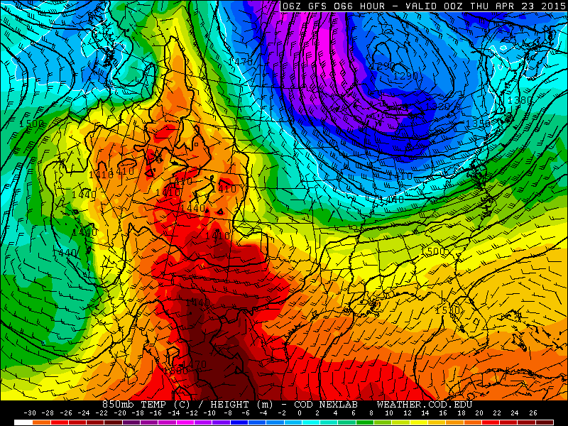
Midweek 850mb Temps
This
storm system will also be responsible for the big and continued cool
down across the eastern two-thirds of the nation through the week. Note
the strong winds blowing out of Canada on the backside of the center of
low pressure in Ontario. Again, it weather feature looks to be nearly
stationary through the week ahead.
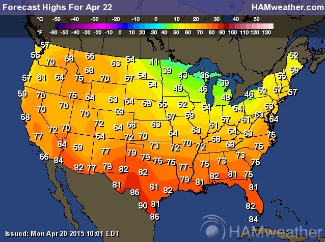
Wednesday Highs
High
temperatures on Wednesday in the Midwest/Great Lakes Region look more
like readings in March. 30s and 40s will be found across the far north,
while highs in the 50s and 60s will be found across the Ohio
Valley/Middle Mississippi Valley.
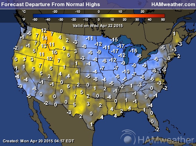
Wednesday Highs From Average
Highs
on Wednesday will be running nearly 10F to 20F below average! The good
news is that this chilly weather looks to gradually fade a bit by the
end of the month.
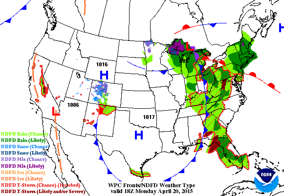
National Weather Outlook
Our
stubborn and slow moving storm system will be in no hurry to exit the
Great Lakes Region/Ontario. Note how the area of low pressure seems to
get stuck in this area for several days. Unfortunately, that means more
windy, cool weather for us with wrap around light rain/snow showers near
the international border. Another area of low pressure looks to develop
across the Southern Plains by midweek, kicking off another round of
showers/storms, some of which could be strong to severe.
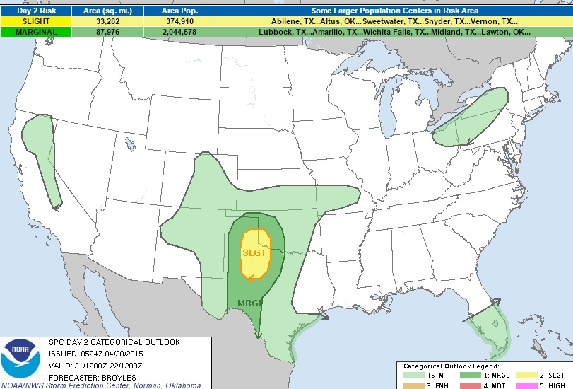
Severe Threat Tuesday
...SUMMARY...
THUNDERSTORM DEVELOPMENT IS EXPECTED TO TAKE PLACE EARLY TUESDAY
EVENING ACROSS THE SOUTHERN PLAINS WHERE LARGE HAIL AND WIND DAMAGE WILL
BE POSSIBLE. THUNDERSTORMS MAY ALSO FORM OVER PARTS OF THE SOUTHERN AND
CENTRAL ROCKIES...EASTERN GREAT LAKES...SOUTH-CENTRAL FLORIDA PENINSULA
AND IN THE SIERRA NEVADA. ...SRN PLAINS... AN UPPER-LEVEL RIDGE IS
FORECAST TO MOVE EWD INTO THE SRN ROCKIES ON TUESDAY AS A SFC LOW
DEVELOPS ACROSS THE SRN HIGH PLAINS. LOW-LEVEL FLOW IS FORECAST TO
STRENGTHEN ACROSS THE SRN PLAINS TUESDAY RESULTING IN MOISTURE ADVECTION
WITH SFC DEWPOINTS INCREASING INTO THE LOWER 60S F ACROSS MUCH OF THE
TX HILL COUNTRY. FURTHER NORTHWEST...SFC DEWPOINTS COULD REACH THE MID
TO UPPER 50S F IN THE LOW ROLLING PLAINS BY LATE AFTERNOON. AN AXIS OF
INSTABILITY IS FORECAST TO BE IN PLACE BY LATE AFTERNOON ALONG THE ERN
EDGE OF THE CAPROCK WHERE MLCAPE VALUES COULD REACH 1500 J/KG. IN
ADDITION...NAM FORECAST SOUNDINGS FOR CHILDRESS AT 03Z/WED SHOW 40-45 KT
OF 0-6 KM SHEAR WITH 700 TO 500 MB LAPSE RATES NEAR 8.5 C/KM. THE STEEP
LAPSE RATES AND MODERATE DEEP-LAYER SHEAR WOULD SUPPORT LARGE HAIL IF
CELLS CAN INITIATE ACROSS WEST TX DURING THE EVENING. THE NAM...GFS AND
ECMWF AGREE THAT CELLS WILL DEVELOP BY TUESDAY EVENING BUT ARE IN
SLIGHTLY DIFFERENT LOCATIONS. THIS GIVES ENOUGH CONFIDENCE TO KEEP THE
SLIGHT RISK IN PLACE OVER THE LOW ROLLING PLAINS. EVEN IF INITIATION
TAKES PLACE LATER IN THE EVENING...THE INCREASE IN INSTABILITY SHOULD
MAINTAIN POTENTIAL FOR SUPERCELLS WITH LARGE HAIL. THE ACTIVITY MAY
BECOME ELEVATED BUT HAIL COULD STILL OCCUR AS A LOW-LEVEL JET
STRENGTHENS ACROSS THE SRN PLAINS LATE IN THE EVENING AND INTO THE
OVERNIGHT PERIOD.
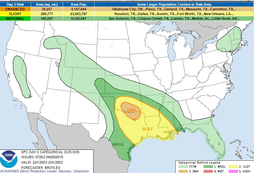
Severe Threat Wednesday
...SUMMARY...
THUNDERSTORMS WITH WIND DAMAGE AND LARGE HAIL ARE EXPECTED TO DEVELOP
FROM THE SOUTHERN PLAINS SOUTHEASTWARD ACROSS THE ARKLATEX AND INTO THE
LOWER MISSISSIPPI VALLEY. MARGINALLY SEVERE THUNDERSTORMS MAY DEVELOP
ACROSS PARTS OF THE SOUTHERN AND CENTRAL HIGH PLAINS AND IN SOUTH
CENTRAL TEXAS. THUNDERSTORM DEVELOPMENT MAY ALSO OCCUR ACROSS PARTS OF
THE CENTRAL TO NORTHERN ROCKIES AND SIERRA NEVADA. ...SRN
PLAINS/ARKLATEX AN UPPER-LEVEL RIDGE IS FORECAST TO MOVE EWD ACROSS THE
SRN ROCKIES ON WEDNESDAY AS SFC LOW PRESSURE IN THE SRN HIGH PLAINS
DEEPENS AND MOVES SEWD. A WARM FRONT MAY BE PRESENT ACROSS SRN OK
EXTENDING ESEWD INTO AR. ALONG AND SOUTH OF THE BOUNDARY...SFC DEWPOINTS
SHOULD BE IN THE LOWER TO MID 60S WITH MODERATE INSTABILITY DEVELOPING
ACROSS MUCH OF THE WARM SECTOR BY AFTERNOON. AS A CAP WEAKENS DURING THE
DAY...THUNDERSTORM DEVELOPMENT APPEARS POSSIBLE ALONG THE WARM FRONT
AND FURTHER SOUTHEASTWARD ACROSS THE ARKLATEX NEAR THE ERN EDGE OF THE
STRONGEST INSTABILITY. AN MCS WILL BE POSSIBLE ACROSS THE REGION LATE
WEDNESDAY AFTERNOON WITH COLD-POOL ORGANIZATION ALSO POSSIBLE BY
EVENING. NAM FORECAST SOUNDINGS FROM OKLAHOMA CITY SEWD TO NEAR THE RED
RIVER AT 00Z/THU SHOW MLCAPE IN THE 2000 TO 2500 J/KG RANGE WITH 0-6 KM
SHEAR OF 45 TO 50 KT. THIS WOULD SUPPORT SEVERE STORMS WITH LARGE HAIL
AND WIND DAMAGE. THE MAIN QUESTION IS WHAT STORM MODE WILL DOMINANT. IF
CELLS REMAIN DISCRETE...THEN SUPERCELLS WOULD BE THE MOST FAVORED STORM
TYPE. HOWEVER...THE PATTERN WOULD SUGGEST COLD-POOL ORGANIZATION WHICH
WOULD FAVOR A LINEAR STRUCTURED MCS WITH ENHANCED WIND DAMAGE POTENTIAL.
EITHER WAY...SOME TORNADOES CAN BE EXPECTED WITH ROTATING CELLS
ASSOCIATED WITH THE BETTER ORGANIZED STORM CLUSTERS. WILL ADD A 30
PERCENT SEVERE PROBABILITY FROM NEAR AND SOUTH OF OKC SEWD TO NEAR AND
EAST OF DALLAS. FURTHER TO THE SOUTH ACROSS SE TX AND LA...FORECAST
SOUNDINGS AT 21Z ON WEDNESDAY SHOW MODERATE INSTABILITY AND STRONG
DEEP-LAYER SHEAR. DUE TO THIS ENVIRONMENT...CELLS THAT CAN INITIATE
ALONG LOCALIZED CONVERGENCE ZONES COULD ROTATE AND POSE A THREAT FOR
WIND DAMAGE AND HAIL. A SEVERE THREAT COULD ALSO DEVELOP DURING THE LATE
EVENING OR IN THE OVERNIGHT PERIOD AS AN MCS APPROACHES THE REGION FROM
THE NORTHWEST. ...ERN CO/SW KS/TX AND OK PANHANDLES... AN UPPER-LEVEL
RIDGE IS FORECAST TO MOVE EWD ACROSS THE SRN ROCKIES WEDNESDAY AS SFC
LOW PRESSURE DEEPENS ACROSS THE SRN HIGH PLAINS. UPSLOPE FLOW IS
FORECAST FROM NEAR THE SFC LOW EXTENDING NWD ACROSS THE CNTRL HIGH
PLAINS. THUNDERSTORM DEVELOPMENT MAY TAKE PLACE BY AFTERNOON ALONG A SFC
TROUGH IN THE TX PANHANDLE AND IN ERN CO. FORECAST SOUNDINGS FOR LAMAR
CO AND THE OK PANHANDLE AT 00Z/THU SHOW MLCAPE AROUND 1500 J/KG WITH 0-6
KM SHEAR NEAR 40 KT. THIS COMBINED WITH A RELATIVELY DRY BOUNDARY
LAYER...SFC DEWPOINTS IN THE UPPER 40S F...WOULD SUPPORT MARGINALLY
SEVERE STORMS WITH WIND DAMAGE AND HAIL POSSIBLE MAINLY DURING THE LATE
AFTERNOON AND EARLY EVENING.
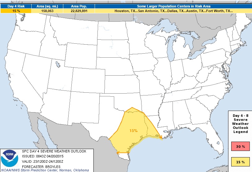
Severe Threat Thursday
...DISCUSSION...
THE MEDIUM-RANGE MODELS INCLUDING THE ECMWF AND GFS SOLUTIONS BEGIN THE
4 DAY 8 DAY PERIOD WITH AN UPPER-LEVEL RIDGE OVER THE SRN PLAINS
EXTENDING NNWWD INTO THE CNTRL HIGH PLAINS. THE MODELS MOVE THIS FEATURE
EWD ON THURSDAY/DAY 4 ACROSS A WARM SECTOR OVER THE ERN TWO-THIRDS OF
TX...SRN OK AND LA. ISOLATED TO SCATTERED THUNDERSTORM DEVELOPMENT WILL
BE POSSIBLE ACROSS THE WARM SECTOR WHERE MODERATE INSTABILITY AND STRONG
DEEP-LAYER SHEAR SHOULD MAKE CONDITIONS FAVORABLE FOR SEVERE STORMS. AN
ENHANCED THREAT FOR WIND DAMAGE AND LARGE HAIL COULD DEVELOP ACROSS THE
REGION THURSDAY AFTERNOON AND EVENING WHERE A SLIGHT RISK HAS BEEN
ADDED. MODEL SOLUTIONS DIVERGE SHARPLY ON FRIDAY/DAY 5 WITH THE ECMWF
MOVING AN NEGATIVELY TILTED UPPER-LEVEL LOW INTO THE CNTRL HIGH PLAINS
WHILE THE GFS MOVES A POSITIVELY TILTED UPPER-LEVEL TROUGH OVER THE SRN
HIGH PLAINS AND CNTRL PLAINS. THE ECMWF SOLUTION WOULD BE FAVORABLE FOR
SEVERE STORMS IN THE SRN AND CNTRL PLAINS WHILE THE FASTER GFS SOLUTION
WOULD BE FAVORABLE FOR SEVERE STORMS OVER THE LOWER TO MID MS VALLEY. AT
THIS POINT...AM LEANING TOWARD THE SLOWER ECMWF SOLUTION WHICH WOULD
MEAN A POSSIBILITY FOR AN ENHANCED SEVERE THREAT IN FROM NORTH TX NWD
INTO SRN KS. LARGE HAIL...WIND DAMAGE AND TORNADOES WOULD BE POSSIBLE
FRIDAY AFTERNOON AND EVENING IN THE SRN PLAINS. THE POTENTIAL EXISTS FOR
AN OUTBREAK OF SEVERE STORMS IF THE ECMWF SOLUTION VERIFIES. AT THIS
POINT...THE LARGE SPREAD IN MODEL SOLUTIONS IS TOO GREAT TO ADD AN
ENHANCED SEVERE THREAT FOR FRIDAY. ON SATURDAY/DAY 6...THE MODELS MOVE
THE SYSTEM QUICKLY EWD ACROSS THE MS VALLEY WITH A ZONAL FLOW PATTERN
DEVELOPING IN THE GULF COAST STATES. THIS PATTERN WOULD MAKE
THUNDERSTORM DEVELOPMENT POSSIBLE IN THE GULF COAST STATES WITH A SEVERE
THREAT POSSIBLE THERE DURING THE AFTERNOON. EVEN SO...PREDICTABILITY
REMAINS QUITE LOW LATE IN THE DAY 4 TO 8 PERIOD.
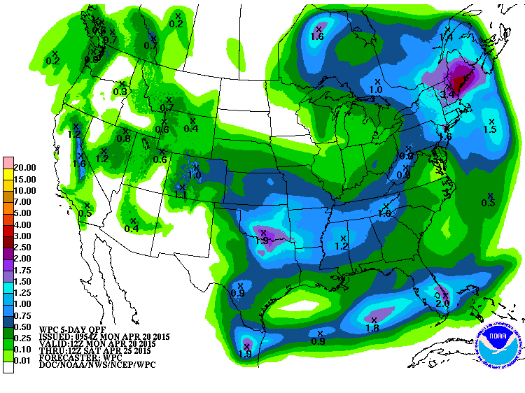
Precipitation Outlook
According
to NOAA's HPC, the 5 day precipitation forecast suggests pockets of
heavy moisture across parts of the Northeast, South-central and Western
U.S. Keep in mind that some folks in the South-central U.S. have already
had a ton of moisture so far this month, so any additional heavy
moisture could lead to flooding!
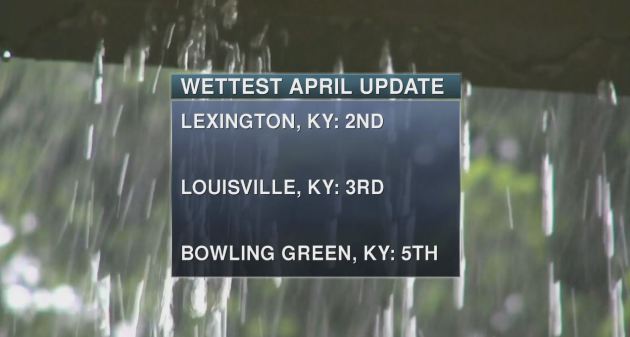
Top April Rainfall Reports
As of April 19th, these were some of the top rainfall reports so far this month! Note that 3 of these locations are in Kentucky!
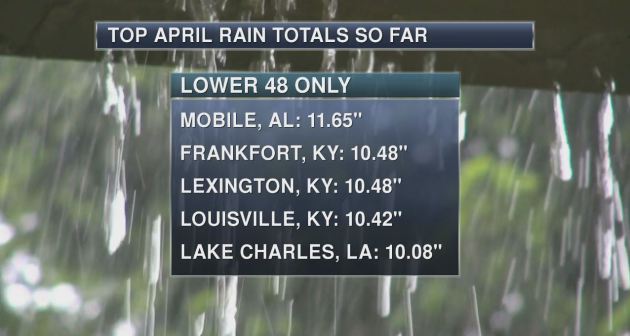
Interestingly,
some locations in Kentucky are in the top 5 wettest April's in recorded
history as we still have about another week and a half left!
"The Earth Has an Eerie Hum and Now We Know What's Causing It"
"Scientists
have long known that Earth produces an eerie low-frequency hum that's
inaudible to humans but detectable with seismic instruments. But as for
what's causing this "microseismic" activity, scientists have never been
sure.""Until now."
"A new study published online Feb. 10, 2015 in the journal Geophysical Research Letters indicates that the hum is largely due to ocean waves that cause our planet to vibrate subtly -- or "ring," as the researchers put it."
See more from HuffingtonPost.com HERE:
"The Greatest Natural Disaster That Almost Was"
More advanced warnings of incoming weather systems sound like a great idea, but researchers are learning that people don’t always do what’s expected.
The National Oceanic and Atmospheric Administration’s Severe Storms Laboratory is developing a system, called Warn-on-Forecast, that could one day provide tornado warnings an hour or more before a twister hits, more than quadrupling the current 14 minutes of warning time (SN: 5/2/15, p. 20). Forecasters, however, worry about how people will spend that extra time, says Kim Klockow, a meteorologist and behavioral scientist at University Corporation for Atmospheric Research who is based in Silver Spring, Md.
Historical storms suggest that people can make the wrong call, she says. On May 31, 2013, a monster 4.2-kilometer-wide twister touched down outside Oklahoma City. Just 11 days before, a tornado ravaged nearby Moore, Okla., damaging as many as 13,000 homes and killing 24 people. With that disaster fresh on people’s minds (plus a few local weather reports urging people without basements to head south), thousands jumped into their cars and drove instead of taking shelter. The highways quickly became a congested, chaotic mess. Cars headed south on northbound lanes and gridlock extended more than 40 kilometers out of the city. “They just left their houses and headed south,” Klockow says.
Things soon got worse...
Read more from ScienceNews.org HERE:
(Image courtesy: DANIEL RODRIGUEZ/FLICKR)
Thanks for checking in and have a great rest of your week! Don't forget to follow me on Twitter @TNelsonWX

No comments:
Post a Comment