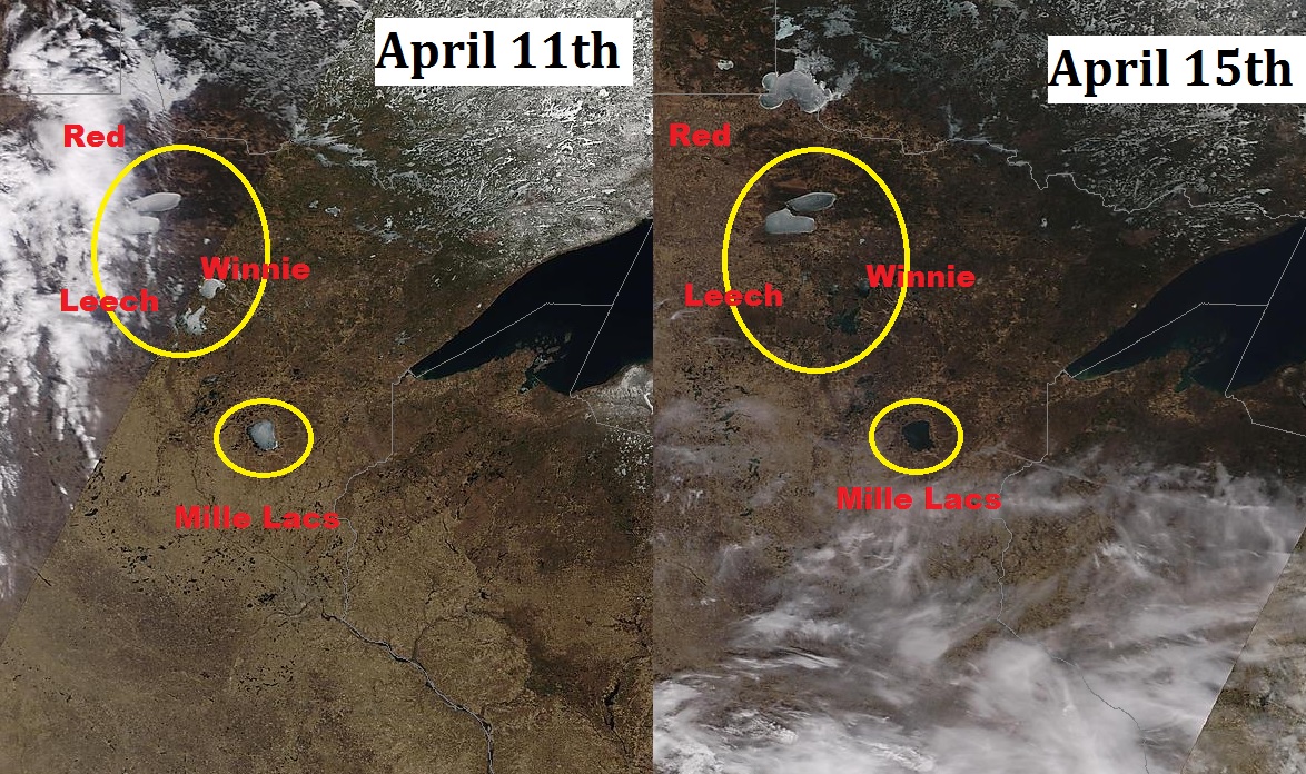
According to the MN DNR, Lake Mille Lacs was ice out as of Monday, April 13th; (Average ice out: April 25th). Take a look at the satellite images below from April 11th to April 15th, note that difference in color on Mille Lacs from when there was still ice on the lakes vs. ice out.
Current Minnesota Lakes With Ice Out
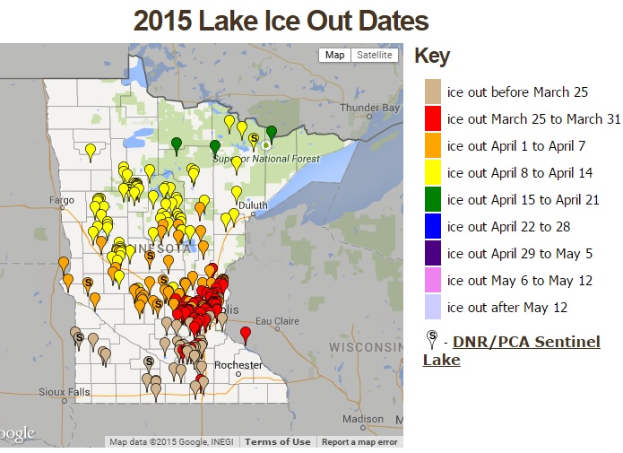
According to the MN DNR, here are all the Minnesota lakes that have reported "Ice Out" as of April 15th. Note that a few lakes across the far north have already reported ice out; keep in mind that most of the northern-most lakes see average ice out in late April/early May.
See more ice out information from the MN DNR HERE:
Average Ice Out Dates
Tall Tornado Tales
By Paul Douglas
"If a dog bites a man that's not news. If a man bites a dog, that's news!" the old saying goes. Crime stories are on the front page of the paper, and some of us perceive threats around every corner. A major tornado outbreak leads the TV newscast and paranoia peaks; suddenly every cloud looks like a twister. Perception becomes reality.
My favorite tornado myths? Southwest corner of a basement is safest? Not true. Under the stairs, under a heavy table lowers the risk of being crushed by debris. Open a window to relieve air pressure? Wrong. It won't save your house, and it's time you should be spending taking cover. Greenish/yellowish sky before a tornado? Sometimes, due to white sunlight shining through suspended hailstones. Remember, 1 in 100 thunderstorms will ever spin up a tornado. But like a good Boy Scout we should all be prepared. Enjoy 70s Friday because a soaking rain pushes into Minnesota Saturday and lingers Sunday. Up to an inch of badly-needed rain may fall. Another million-dollar rain is possible late next week.
We'll be on the chilly, northern side of the storm track. No wild thunderstorms into late April. May and June are peak months for violent storms here.
================
TONIGHT: Partly to mostly cloudy and quiet. Low: 45
FRIDAY: More sun, still lukewarm and pleasant. High: 72. Winds: WNW 5-10
FRIDAY NIGHT: Partly cloudy and quiet. Low: 49. Winds: Turning NE 5
SATURDAY: Clouds increase - showers late, especially south/west of the metro. High: 64
SUNDAY: Soaking rain, up to 1" possible. Wake-up: 52. High: 56
MONDAY: Showers taper, clouds linger. Wake-up: 41. High: 48
TUESDAY: Mostly cloudy, light jacket weather. Wake-up: 37. High: 45
WEDNESDAY: More clouds than sun, cool. Wake-up: 34. High: 46
THURSDAY: Partly sunny, greening up fast! Wake-up: 32. High: 50
=======================
This Day in Weather History
April 17th
1965: The Mississippi River crested at St. Paul 4 feet above the previous record. High water records were set all the way down to Missouri in later days. There was little loss of life due to early warnings.
=================
Average High/Low for Minneapolis
April 17th
Average High: 59F (Record: 85F set in 1985)
Average Low: 10F (Record: 10F set in 1875)
================
Sunrise/Sunset for Minneapolis
April 17th
Sunrise: 6:24am
Sunset: 8:01pm
================
Moon Phase for April 17th at Midnight
0.5 Days Before New Moon

===================
Minneapolis Temperature Outlook
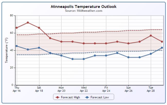
As of April 15th, Minneapolis was running 4.4° above average with temperatures hitting 70° or better 4 times already this month. The warmest day was the record setting 84° on April 1st! We stay mild through the early part of the weekend, but note the cooldown as we head into next week. Temperatures look to be a little below average through much of the 2nd half of the month!
==========================
Friday Weather Outlook
Our mostly dry and mild week continues on Friday with temperatures warming into the low/mid 70s across the southern half of the state. The northern part of the state may hold in the 60s, but a fairly light breeze and mostly sunny skies will make for an extremely nice mid April day in Minnesota. Enjoy!!
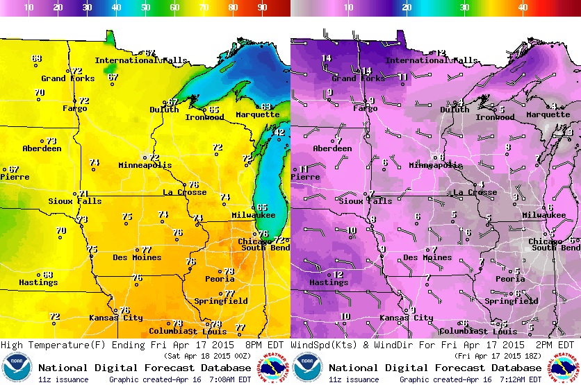
Friday Weather Continued...
Look for mostly sunny skies on Friday with a few more afternoon clouds across the southwestern part of the state. Any rain chances should stay across the Central Plains until later Saturday when moisture begins to funnel north into the state.
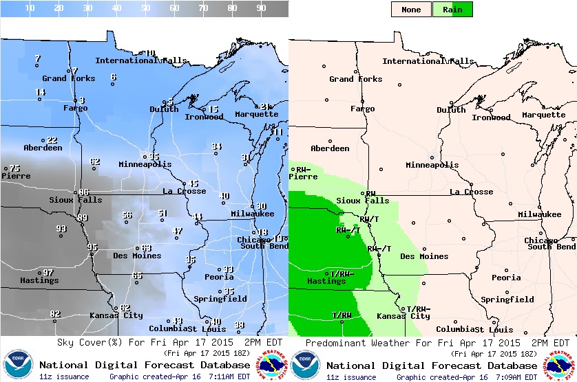
Weather Outlook
The loop below shows fairly quiet weather conditions on Friday and early Saturday, but a slow moving storm system sitting over the Central Rockies will eventually begin to push moisture in our directions later Saturday through Sunday. The second half of the weekend looks soggy...
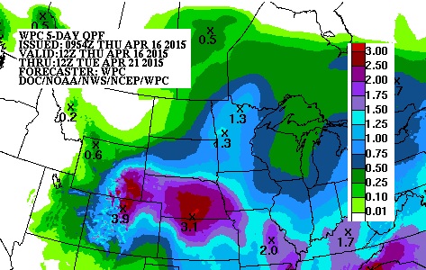
Rainfall Potential Through 7pm Saturday
Weather conditions sour as we head into the afternoon/evening hour Saturday. Note that the bulk of the precipitation shows up over the Central Plains through 7pm Saturday.
Precipitation Outlook
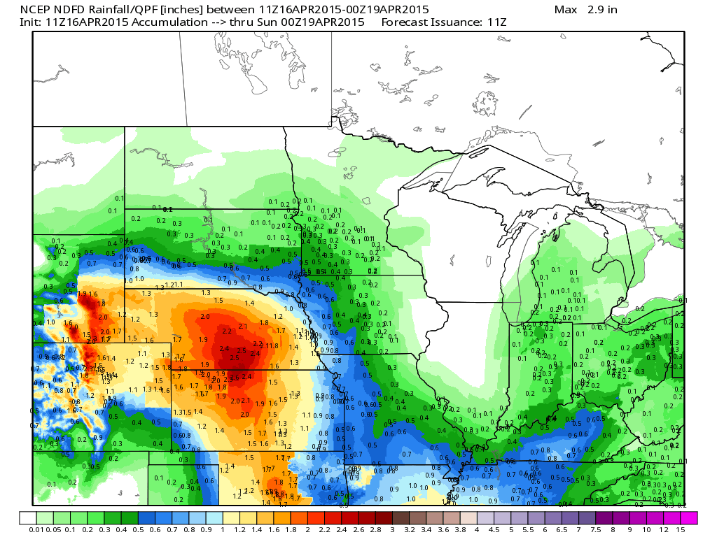
According to NOAA's HPC, the precipitation forecast through AM Tuesday suggests nearly 1"+ rainfall across parts of Minnesota! As of April 15th, Minneapolis was nearly 1.5" below average precipitation since January 1st.
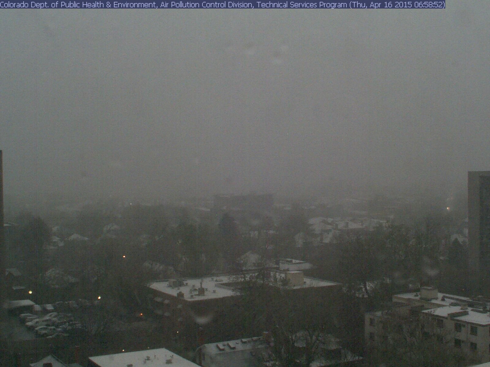
Spring Along the Front Range
Take a look at the snowy webcam from Denver, CO from early Thursday morning. It's amazing how quickly the weather can change along the Front Range in the Spring months... Denver was 75° on Tuesday and is expecting a few inches of slush through the end of the week.
See the latest Denver, CO webcam from the Department of Public Health & Environment HERE:
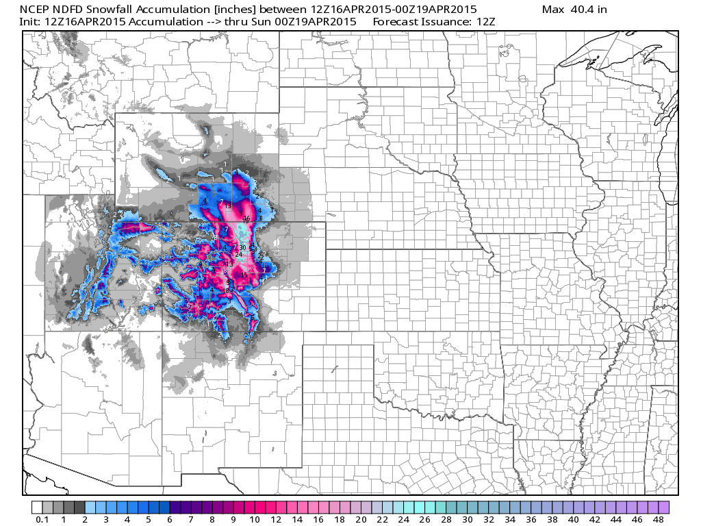
Snowfall Potential Through Saturday
Snowfall forecasts through Saturday suggest nearly 1ft. to 2ft.+ possible in the high elevations across parts of the Central Rockies. Interestingly, some of the lighter/slushier accumulations will be possible in the lower elevations as well!
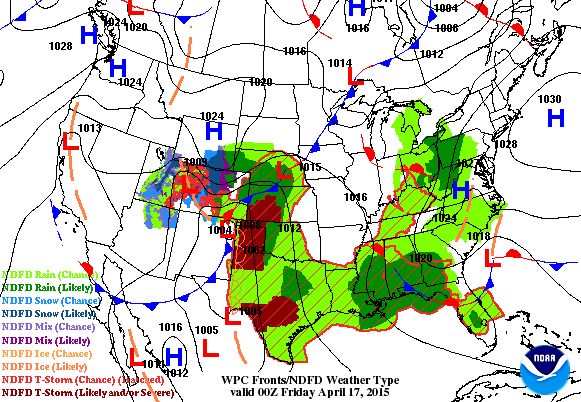
National Weather Outlook
The same storm bringing snow to parts of the Rockies will also be responsible for several days of shower/thunderstorm activity across the Plains and central U.S.. Thunderstorm chances will remain high over the next several days on the eastern/warmer/more unstable side of the slow moving storm system as it tiptoes eastward.
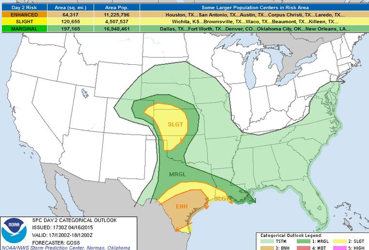
Severe Threat Friday
...SUMMARY...
SCATTERED SEVERE STORMS WITH DAMAGING WIND AND HAIL ARE EXPECTED
OVER SOUTHERN TEXAS FRIDAY AFTERNOON AND EVENING WITH MORE ISOLATED
ACTIVITY EXTENDING INTO LOUISIANA. SEVERE HAIL/WIND AND PERHAPS A
BRIEF TORNADO ARE POSSIBLE ACROSS MUCH OF CENTRAL KANSAS INTO
NORTHWEST OKLAHOMA AND PORTIONS OF SURROUNDING STATES DURING THE
AFTERNOON.
...SYNOPSIS...
A LARGE CUT-OFF UPPER LOW OVER THE SRN ROCKIES IS PROGGED TO DRIFT
SLOWLY NEWD ACROSS CO FRI...AND THIS LOW/TROUGH WILL REMAIN THE
PRIMARY LARGE-SCALE FEATURE ALOFT WITH RESPECT TO THE CONVECTIVE
FORECAST THIS PERIOD.
AT THE SURFACE...LEE-SIDE LOW PRESSURE/TROUGHING WILL REMAIN OVER
THE CENTRAL/SRN HIGH PLAINS VICINITY...WITH THE TROUGH/DRYLINE
MIXING EWD ACROSS WRN KS AND THE TX/OK PANHANDLES AND TX SOUTH
PLAINS DURING THE AFTERNOON. ELSEWHERE...A GENERALLY WEAK/FAIRLY
NONDESCRIPT SURFACE PRESSURE PATTERN WILL PREVAIL.
...CENTRAL AND SRN HIGH PLAINS AREA...
GRADUAL NEWD ADVANCE OF THE UPPER LOW AND SHARPENING OF THE
HIGH-PLAINS DRYLINE NEAR AND S OF AN ERN CO SURFACE LOW WILL PERMIT
AFTERNOON INITIATION OF ISOLATED TO SCATTERED STORMS...WITHIN A
DESTABILIZING AIRMASS FEATURING 500 TO 1000 J/KG MIXED-LAYER CAPE.
WITH LOW-LEVEL SELY FLOW E/NE OF THE LOW EXTENDING AS FAR WWD AS
NERN CO BENEATH ENHANCED MID-LEVEL SSWLYS...SHEAR SUPPORTIVE OF
SUPERCELLS WILL EXIST. THUS -- DEVELOPING STORMS SHOULD QUICKLY
ACQUIRE UPDRAFT ROTATION...AND ASSOCIATED POTENTIAL FOR THE
PRODUCTION OF LARGE HAIL AND LOCALLY DAMAGING WINDS. WHILE MODEST
BOUNDARY-LAYER MOISTURE SHOULD LIMIT TORNADO RISK...A TORNADO OR TWO
CANNOT BE RULED OUT -- PARTICULARLY WHERE LOW-LEVEL FLOW BACKS TO
NEAR ELY N/NE OF THE SURFACE LOW. OVERNIGHT...STORMS SHOULD SPREAD
NEWD ACROSS NWRN OK/KS AND ACROSS SRN NEB...WHILE SEVERE RISK
GRADUALLY DIMINISHES THROUGH THE END OF THE PERIOD.
...PARTS OF CENTRAL AND SRN TX...
FAIRLY WIDESPREAD/PRIOR CONVECTION ACROSS CENTRAL AND S TX IS
EXPECTED LEADING UP TO THE START OF THE DAY 2 PERIOD...THUS
INFLUENCING THE THERMODYNAMIC ENVIRONMENT -- AND IN TURN DETAILS
REGARDING TIMING/LOCATION/DEGREE OF SEVERE RISK WHICH IS EXPECTED TO
EVOLVE ACROSS THE AREA FRI AFTN/EVE.
WITH THAT SAID...MODELS CONTINUE TO PROJECT THAT A SRN-STREAM SPEED
MAX AND ASSOCIATED/ELONGATED AREA OF CYCLONIC VORTICITY NOW WELL OFF
THE BAJA COAST WILL ADVANCE EWD/ENEWD ACROSS NRN MEXICO TOWARD TX BY
AFTERNOON...WITHIN BROAD CYCLONIC FLOW FIELD SURROUNDING THE SRN
ROCKIES LOW. AS AFTERNOON DESTABILIZATION OCCURS -- PARTICULARLY
S/W OF ANY REMNANT CONVECTIVE BOUNDARY...EXPECT STORMS TO REDEVELOP
ACROSS CENTRAL/S TX AND THE ADJACENT HIGHER TERRAIN OF NERN MEXICO.
DEGREE OF ASCENT AND A VERY MOIST BOUNDARY LAYER SUGGESTS POTENTIAL
FOR RAPID UPSCALE GROWTH OF CONVECTION INTO LINES/CLUSTERS.
HOWEVER...WITH LOW-LEVEL ELY/SELY FLOW VEERING/INCREASING WITH
HEIGHT TO WWSWLY...SHEAR WILL SUPPORT UPDRAFT ROTATION WITHIN ANY
DEVELOPING STORM. THUS...EXPECT A MIX OF POSSIBLE SEVERE WEATHER
HAZARDS...INCLUDING HAIL...DAMAGING WINDS...AND POSSIBLY A TORNADO
OR TWO IF LOW-LEVEL SHEAR CAN BE MAXIMIZED LOCALLY INVOF ANY REMNANT
SURFACE BOUNDARIES. OVERNIGHT...EXPECT ONE OR MORE ONGOING STORM
CLUSTERS /AND POSSIBLE ONGOING SEVERE RISK/ TO PROGRESS EWD ACROSS
ERN TX...POSSIBLY REACHING SWRN LA LATE.
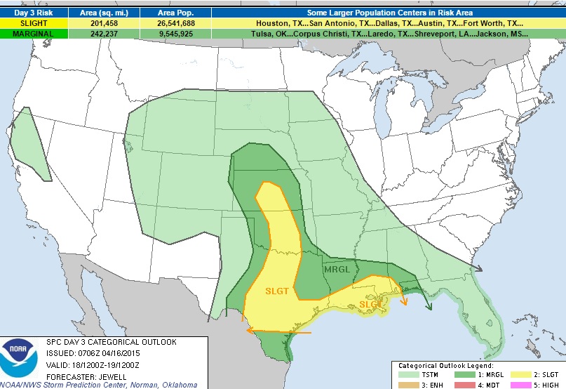
Severe Threat Saturday
...SYNOPSIS... A WEAKENING UPPER LOW IS FORECAST TO DRIFT ACROSS THE CNTRL PLAINS ON SATURDAY WITH SURFACE LOW OVER WRN KS AND DRYLINE ARCING SEWD ROUGHLY ALONG I-35 IN OK AND TX. THE COOL AIR ALOFT ATOP A MOIST LOW-LEVEL AIR MASS WILL RESULT IN AREAS OF STRONG INSTABILITY WITH ISOLATED SEVERE STORMS LIKELY. MEANWHILE...THE SRN STREAM JET WILL REMAIN ACTIVE WITH THE LIKELIHOOD OF AN EARLY DAY/ONGOING AREA OF STRONG STORMS ACROSS ERN TX AND LA. ...ERN TX INTO THE CNTRL GULF COAST... MODELS ARE IN GOOD AGREEMENT DEPICTING AN ONGOING MCS NEAR THE SABINE RIVER SAT MORNING...CONTINUING EWD ACROSS LA...MS DURING THE DAY. THIS POTENTIAL MCS WILL BE SUPPORTED BY A VERY MOIST AIR MASS...AND ENHANCED BY THE SRN-STREAM SHORTWAVE TROUGH. DAMAGING WINDS WILL BE POSSIBLE...BUT VEERING WINDS WITH HEIGHT AND THE MOIST AIR MASS FURTHER SUGGEST A TORNADO CANNOT BE RULED OUT. HOWEVER...ALL THIS IS CONDITIONAL ON HOW THE MCS EVOLVES. ...NRN INTO CNTRL TX LATE AFTERNOON... STRONG HEATING WILL OCCUR NEAR THE DRYLINE BUT WITH WEAK CONVERGENCE. STILL...MODERATE INSTABILITY WILL DEVELOP DUE TO COOL PROFILES ALOFT. HAIL STORMS WILL BE POSSIBLE DESPITE MARGINAL SHEAR PROFILES FOR SUPERCELLS BY THIS TIME DUE TO WEAK LOW-LEVEL WINDS. ...KS INTO OK... WHILE MODEL DIFFERENCES EXIST...THERE LOOKS TO BE A HIGH THREAT OF HAIL ACROSS KS AND OK DURING SAT AFTERNOON DUE TO VERY COLD TEMPERATURES ALOFT COMBINED WITH SURFACE DEWPOINTS STILL IN THE MID TO UPPER 50S F. WEAK CONVERGENCE AND STRONG HEATING NEAR THE DRYLINE WILL RESULT IN AT LEAST ISOLATED STORMS...ALMOST CERTAINLY PRODUCING LARGE HAIL. DEPENDING ON HOW MUCH MOISTURE IS AVAILABLE AND CHARACTER OF THE SHEAR PROFILES...SIGNIFICANT HAIL COULD OCCUR...BUT PREDICTABILITY IS TOO LOW FOR THAT AT THIS TIME AND THE NAM IS LIKELY DEPICTING DEWPOINTS TOO HIGH.
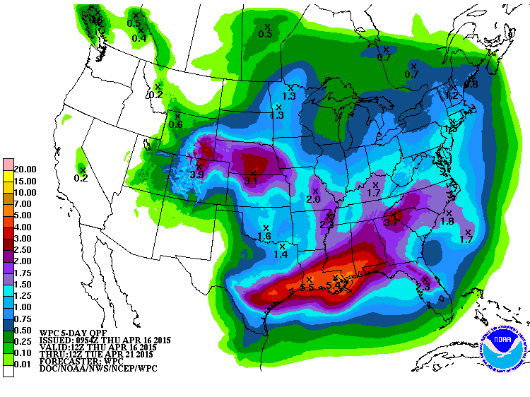
Precipitation Outlook
According to NOAA's HPC, the 5 day precipitation forecast shows heavy moisture across parts of the Central Plains and across the Gulf Coast States thanks to several round of convective activity. Areas of flooding can't be ruled out in a few of these areas (especially across the Gulf Coast States). Meanwhile, the western third of the nation looks to remain mostly dry through early next week.
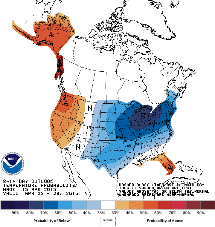
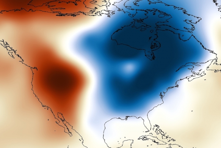
Cooler End of April?
According to NOAA's HPC, the 8 to 14 day temperature outlook (April 23rd - April 29th) suggests a fairly chilly end of April across the eastern U.S. - interestingly, this pattern resembles much of what we've been dealing with over the past several months. Cooler/wetter in the Eastern U.S. and warmer/drier in the Western U.S.
"Scientists Pore Over Warm West, Cold East Divide"
"The curiosity of a growing group of researchers has been piqued by the tenacious temperature divide that has separated East from West over the past two winters as a wild zigzag of the jet stream has brought repeated bouts of Arctic air and snow to the East and kept the drought-plagued West baking under a record-breaking dome of heat."
"That persistent "warm west, cold east” winter pattern has set off a flurry of research aimed at uncovering why those regions of the U.S. spent winter locked in polar opposite situations, with plenty of questions remaining — including how global warming might be influencing whatever set the atmospheric pattern in motion.
The climate shifts of the Pacific Ocean have been considered a primary suspect in driving the seemingly unbreakable divide, in part because many of these have a clear influence on U.S. weather. But two recent studies have pushed past these well-known climate cycles and brought attention to some other, perhaps underappreciated players, in both the Pacific and the Arctic.
In one study, Dennis Hartmann, an atmospheric scientist at the University of Washington, pinpointed a climate cycle that seems to be linked to the most well-known of such phenomena, El Niño. This “new” cycle — which Hartmann calls the North Pacific Mode (NPM) — has been hinted at before, but hasn’t received as much scientific attention as its cousin."
Read more from Climate Central HERE:
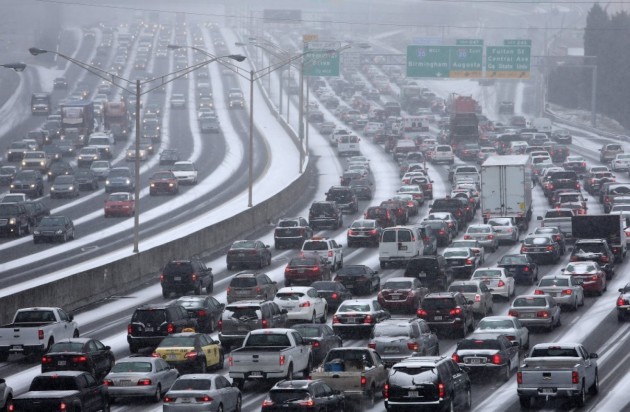
"Senate to hold hearing on improving weather forecast communication"
"Extreme weather is costly. From 2008 to 2013, alone, the price tag of extreme weather events in the U.S. was $309 billion. These costs are soaring even as forecasts improve. But an excellent weather forecast, if not properly communicated and acted upon, is of practically no value.
We can point to numerous recent events in which there were good forecasts but bad, costly decisions, including the so-called “Commutageddon” snowstorm in Washington, D.C. in January 2011 and the crippling snow event in Atlanta in 2014, both of which stranded motorists for hours.
Policymakers are increasingly recognizing the importance of an effective and seamless forecast-decisionmaking continuum. To inform future legislative efforts pertaining to improving weather forecasts and their communication, the Senate Committee on Commerce, Science and Transportation is convening a hearing next Wednesday entitled, “Weathering the Storm: How Can We Better Communicate Weather to Enhance Commerce and Safety?”"
See more from WashingtonPost.com HERE:
(Image courtesy: AP Photo/Atlanta Journal-Constitution,Ben Gray)
"Ticks Are Now Carrying a Virus Worse Than Lyme Disease"
"The Powassan virus is emerging in the Northeast and the Midwest."
"As
the weather warms up, it's tempting to grab the family and the dogs and
head out for a hike. But if you live in a few key areas, you might be
putting yourself at risk of a scary disease.
According
to CBS News, ticks in the Northeast and the Great Lakes area have been
found to be carrying the Powassan virus. It's a rare condition that
produces symptoms similar to Lyme disease, but more severe, and there's
no cure.
The
disease can lead to encephalitis and meningitis, and give you permanent
neurological issues afterward. And it can act much more quickly than
Lyme disease, giving you symptoms within hours of being bitten by a
tick, according toFox News. About 10% of cases that lead to encephalitis
are fatal.
Powassan
is extremely rare, having affected only 50 people in the U.S. over the
past decade. In contrast, 30,000 cases of Lyme disease are reported to
the CDC each year (though the number of people diagnosed with Lyme
disease each year in the United States is estimated to be around
300,000). People who work outdoors or go camping in affected areas are
at a higher risk of infection."

Thanks for checking in and have a great rest of your week! Don't forget to follow me on Twitter @TNelsonWX

No comments:
Post a Comment