Duluth: Friday Sunrise
Friday
was stunning from start to finish across the state. This was the view
from Duluth, MN early Friday as the sun was rising over the western tip
of Lake Superior.

Lake Superior
This
was the view of Lake Superior on Wednesday, April 15th. Note that much
of the lake is ice free except the eastern part of the lake and some the
bays to the north. Also note the white coloring along the south shore
of Lake Superior, that's a little snow still on the ground.

Lake Superior Ice Coverage
According to NOAA's GLERL, 26.8% of Lake Superior was still considered to be ice covered as of April 17th.

Ice Coverage Early April
This was the high resolution satellite image from Sunday, April 5th when nearly 51% of Lake Superior was still ice covered.

Lake Superior Ice Halting Shipping Traffic
Check
out this Startribune story from Wednesday, April 8th... The ice was so
thick earlier this morning that about a dozen ships got stuck in the
eastern part of the lake!
"SAULT STE. MARIE, Mich. — U.S. and
Canadian crews are working to clear a path through ice on eastern Lake
Superior that's left freighters unable to move, including one that had a
hole punched in its hull. The
Canadian Coast Guard says that by Wednesday afternoon, six vessels
heading toward the lower lakes and 12 vessels heading toward upper Lake
Superior were waiting to move. It says that two of the outbound vessels
have cleared the ice field with help from the Canadian Coast Guard ship
Samuel Risley."See the full story from StarTribune HERE:
(Image courtesy: John L. Russell, Associated Press)

=====================
May Tease
By Todd Nelson
WOW!
What a Friday it was... A mild breeze, birds chirping and uninterrupted
sunshine. I made every attempt to enhance my Minnesota winter skin,
although my cheeks are a little rosy today.
Yesterday's
brief encounter with May had many green-thumbers daydreaming about
sticking their nose in the garden. A few cold weather crops can go in
now, but the bulk of your veggies and flowers should hold off until
around/after Mother's Day in mid May.
A slow moving storm system has been stuck over the Central Rockies over the past few days, kicking out nearly 2ft to 4ft of snow in the mountains. Denver, CO saw a high temperature of 75° on Tuesday and woke up to 4" of snow on Friday!
This storm will finally make a move east; showers and rumbles of thunder will begin to move into southern Minnesota by the afternoon and spread through northern part of the state through the evening. Some models are suggesting nearly 1" rain through the end of the weekend, which will help moderate drought that now encompasses nearly 92% of the state.
======================
FRIDAY NIGHT: Mostly clear and quiet. Low: 49. Winds: NW 5.
SATURDAY:
Dry start. Clouds increase with showers/rumbles of thunder
later, especially south/west of the metro. High: 66. Winds: ESE 10-15
SATURDAY NIGHT: Rain/rumbles of thunder likely. Low: 49SUNDAY: Wet start. Rain tapers by PM. High: 58. Winds: SE turning NW 10.
MONDAY: Breezy & cooler with a rain/snow mix up north. Wake-up: 40. High: 50
TUESDAY: A few AM flakes. Still breezy and cool. Wake-up: 33. High: 48
WEDNESDAY: More sun, a little warmer. Wake-up: 33. High: 51
THURSDAY: Breezy with sunshine. Wake-up: 35. High: 54
FRIDAY: Breezy. Bright sunshine. Wake-up: 35 High: 54
=======================
This Day in Weather History
April 18th
1965: The Mississippi River crested at St. Paul 4 feet above the previous record. High water records were set all the way down to Missouri in later days. There was little loss of life due to early warnings.
========================
Average High/Low for Minneapolis
April 18th
Average High: 59F (Record: 89 set in 1895)
Average Low: 38F (Record: 21 set in 1953)
=======================
Sunrise/Sunset Times for Minneapolis
April 18th
Sunrise: 6:23am
Sunset: 8:03pm
=======================
Moon Phase for April 18th
New Moon 1:57pm (Ojibwe Maple Sugar)

========================
Minneapolis Temperature Trend
After an incredibly mild Friday, temperatures will take a slide through the weekend/early next week into more March-like weather. Extended forecasts suggest slightly cooler than average temperatures continuing through much of the rest of the month...

==================
Saturday Weather Outlook
Weather conditions on Saturday will sour through the day. High temperatures will fall from the 70s on Friday to the 60s on Saturday. Winds will also increase out of the E/SE 10-20mph.

Saturday Weather Outlook
The slow moving storm system that has been impacting the Plains over the past few days will begin moving into our region over the weekend. Rain will start moving into the southern part of Minnesota around midday and spread through the rest of the region through the evening. Sunday looks a bit soggy too.

Rainfall Potential
The rainfall potential through 7pm Sunday suggests a fairly widespread 0.50" to 1.00" swath across the state. Some of the heaviest appears to be across the southern part of the state.

Minnesota Drought
As of this week, the U.S. Drought Monitor had nearly 92% of the state under MODERATE DROUGHT

Heavy Snow in April
Take a look at the image below from the Wyoming Highway Patrol Facebook page... Heavy snow and high speeds led to this near 50-car pile up along highway I-80 on Thursday.
*Update for I 80 multi-vehicle crash between Cheyenne and Laramie*
33 commercial vehicles and 12 passenger vehicles is the latest estimate that were involved in one of the three crash sequences along with multiple other vehicles that were not part of an actual crash, but became stranded in the event due to road blockage. 16 motorists were transported by ambulance and 11 motorists were transported by a Laramie County School District bus to Cheyenne Regional Medical Center in Cheyenne, Wyoming. Six of those injured were critical to serious leg or spine injuries. No fatalities were reported from this event.
Speeds too fast for the blizzard conditions and loss of control are being investigated as contributing factors in the crashes that caused a "domino" style chain reaction after the first couple of vehicles lost control.
Agencies that responded were the Wyoming Highway Patrol, Laramie County Sheriff's Office, Albany County Sheriff's Office, Wyoming Office of Homeland Security, Laramie County Fire Districts 1, 2, and 10, AMR Ambulance, F.E. Warren First Responders, Wyoming National Guard First Responders, City of Laramie Fire Department, WYDOT and multiple tow companies from Cheyenne and Laramie. Joint training between all of these agencies and their dispatchers was credited for the rapid response, extrication, treatment and transport of those injured in the event.
Interstate 80 between Cheyenne and Laramie is expected to remain closed into tonight and possibly through the early morning hours of tomorrow (April 17th) as the investigation and cleanup continues through the evening. Weather will hold a strong determining factor for the investigators and cleanup crews as to when I 80 will be ready to reopen. Again, we ask motorists at the road closed gates in Cheyenne and Laramie to please be patient and check for updates at www.wyoroad.info or by calling 1-888-WYO-ROAD (1-888-996-7623)

Heavy Snow Reports...
Here
are some of the heaviest snowfall reports I could find from earlier
this week. These reports came in from the National Weather Service out
of Salt Lake City, UT - note the 45" amount from Snowbird in the Wasatch
Mountains!!

Active Thursday Weather
From
heavy snow in the Mountains to severe weather and tornadoes in the
Central U.S.; it was a very active Thursday. In all, there were nearly
150 reports of severe weather (hail, damaging winds and tornadoes), 10
of which were tornado reports.

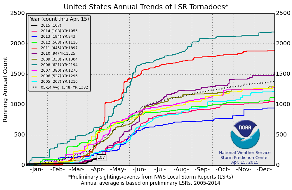
2015 Tornado Reports
According
to NOAA's SPC (thru April 15th), the PRELIMINARY tornado count was 107.
Until recently, 2015 was off to an incredibly slow start to the severe
weather season. We are currently on pace with 2014, which was a pretty
quiet year. The 2005-2014 tornado average through April 15th is 348.
National Weather Outlook
Our
slow moving storm system will continue to pump out snow across the
Intermountain-west with heavy rain and strong to severe thunderstorms
across the Plains into the weekend. Snow will begin to taper by late
weekend, while heavy rain and strong to severe storms begin to shift a
little farther east on Sunday.

Severe Threat Saturday
...SUMMARY...
SEVERE THUNDERSTORMS WITH WIND DAMAGE AND HAIL ARE POSSIBLE SATURDAY
ACROSS MUCH OF CENTRAL AND EASTERN TEXAS EASTWARD INTO LOUISIANA.
THUNDERSTORMS WITH HAIL AND A FEW STRONG WIND GUSTS ARE ALSO
POSSIBLE FROM OKLAHOMA NORTHWESTWARD ACROSS KANSAS INTO NORTHEASTERN
COLORADO.
SEVERE THUNDERSTORMS WITH WIND DAMAGE AND HAIL ARE POSSIBLE SATURDAY
ACROSS MUCH OF CENTRAL AND EASTERN TEXAS EASTWARD INTO LOUISIANA.
THUNDERSTORMS WITH HAIL AND A FEW STRONG WIND GUSTS ARE ALSO
POSSIBLE FROM OKLAHOMA NORTHWESTWARD ACROSS KANSAS INTO NORTHEASTERN
COLORADO.
...SOUTH AND CNTRL TX/SW LA...
AN UPPER-LEVEL TROUGH IS FORECAST TO MOVE INTO THE SRN HIGH PLAINS
ON SATURDAY AS A SFC TROUGH DEVELOPS ACROSS WCNTRL TX EXTENDING SWD
INTO THE RIO GRANDE VALLEY. A LOW-LEVEL JET IS FORECAST AT THE START
OF THE PERIOD OVER LA WHERE WIDESPREAD THUNDERSTORM DEVELOPMENT MAY
BE ONGOING. THIS ACTIVITY COULD HAVE A MARGINAL SEVERE THREAT DURING
THE DAY. FURTHER TO THE WEST...THE MODELS SUGGEST A CORRIDOR OF
MODERATE INSTABILITY WILL BE IN PLACE BY AFTERNOON ACROSS SRN AND
CNTRL TX. ALTHOUGH CONVECTIVE COVERAGE IS UNCERTAIN...THE GFS AND
ECWMF SOLUTIONS DEVELOP CONVECTION FROM THE TX HILL COUNTRY SEWD TO
THE TX COAST SATURDAY AFTERNOON.
GFS FORECAST SOUNDINGS AT 21Z/SATURDAY AT CORPUS CHRISTI SHOW MLCAPE
AROUND 1500 J/KG WITH SFC DEWPOINTS IN THE LOWER 60S F AND STEEP LOW
TO MID-LEVEL LAPSE RATES. IN ADDITION...0-6 KM SHEAR IS 45 TO 50 KT
WITH SOME DIRECTIONAL SHEAR BELOW 850 MB. THIS SHOULD SUPPORT
SUPERCELL DEVELOPMENT WITH LARGE HAIL AND WIND DAMAGE POSSIBLE. IF
THE MORE AGGRESSIVE GFS SOLUTION IS CLOSER TO VERIFYING...THEN AN
ENHANCED SEVERE THREAT MAY DEVELOP ACROSS PARTS OF SRN AND CNTRL TX
SATURDAY AFTERNOON. FURTHER TO THE NORTH ACROSS NCNTRL TX...ENOUGH
INSTABILITY IS FORECAST FOR A SEVERE THREAT. HOWEVER...DEEP-LAYER
SHEAR SHOULD BE WEAKER HELPING TO KEEP THE POTENTIAL FOR HAIL AND
WIND GUSTS MORE ISOLATED.
...SRN AND CNTRL PLAINS...
AN UPPER-LEVEL LOW IS FORECAST TO MOVE EWD INTO THE CNTRL HIGH
PLAINS ON SATURDAY AS A SFC LOW DEEPENS ACROSS THE TX PANHANDLE. A
NARROW CORRIDOR OF INSTABILITY IS FORECAST FROM WRN OK NWWD INTO
WCNTRL KS AND INTO NERN CO. THE AIRMASS SHOULD BECOME UNCAPPED BY
AFTERNOON WITH SCATTERED THUNDERSTORMS DEVELOPING ALONG THIS
CORRIDOR. A FEW CLUSTERS OF THUNDERSTORMS MAY ORGANIZE AND PERSIST
FROM LATE AFTERNOON INTO THE EVENING.
GFS FORECAST SOUNDINGS AT 00Z/SUNDAY IN NW OK AND SRN KS SHOW SFC
DEWPOINTS NEAR 60 F WITH MLCAPE OF 1000 TO 1500 J/KG. IN
ADDITION...0-6 KM SHEAR IS FORECAST TO BE NEAR 40 KT WITH STEEP
MID-LEVEL LAPSE RATES. THIS SHOULD SUPPORT SEVERE STORMS WITH HAIL
AND STRONG WIND GUSTS POSSIBLE. CELLS THAT CAN DEVELOP IN AREAS
WHERE INSTABILITY IS MAXIMIZED...MAY BE ABLE TO ROTATE AND PRODUCE
LARGER HAILSTONES. FURTHER TO THE NORTHWEST INTO NW KS...SRN NEB AND
NE CO...INSTABILITY IS FORECAST TO BE WEAKER THAN IN THE SRN PLAINS.
HOWEVER...COLD AIR ALOFT AND STEEP LAPSE RATES BENEATH THE
UPPER-LEVEL LOW MAY BE ENOUGH FOR STORMS THAT PRODUCE HAIL.

Severe Threat Sunday
...SUMMARY...
THUNDERSTORMS WITH WIND DAMAGE AND SEVERE HAIL WILL BE POSSIBLE FROM
EASTERN PARTS OF THE SOUTHERN PLAINS EASTWARD TO THE CENTRAL GULF
COAST STATES ON SUNDAY AFTERNOON. THUNDERSTORMS WITH WIND DAMAGE
POTENTIAL WILL ALSO BE POSSIBLE ACROSS THE MID MISSISSIPPI VALLEY
SUNDAY.
THUNDERSTORMS WITH WIND DAMAGE AND SEVERE HAIL WILL BE POSSIBLE FROM
EASTERN PARTS OF THE SOUTHERN PLAINS EASTWARD TO THE CENTRAL GULF
COAST STATES ON SUNDAY AFTERNOON. THUNDERSTORMS WITH WIND DAMAGE
POTENTIAL WILL ALSO BE POSSIBLE ACROSS THE MID MISSISSIPPI VALLEY
SUNDAY.
...ARKLATEX/LOWER TO MID MS VALLEY...
A BROAD UPPER-LEVEL TROUGH IS FORECAST TO MOVE EWD ACROSS THE SRN
AND CNTRL PLAINS ON SUNDAY AS A COLD FRONT ADVANCES QUICKLY EWD INTO
THE ARKLATEX AND OZARK MOUNTAINS. AHEAD OF THE FRONT...A BROAD WARM
SECTOR IS FORECAST FROM EAST TX EWD INTO THE CNTRL GULF COAST STATES
WHERE MODERATE INSTABILITY SHOULD BE IN PLACE BY AFTERNOON. MODEL
FORECASTS ARE IN FAIRLY GOOD AGREEMENT...DEVELOPING CONVECTION ALONG
A PRE-FRONTAL TROUGH JUST AHEAD THE FRONT AND MOVING THE CONVECTION
EWD ACROSS THE ARKLATEX AND MID MS VALLEY SUNDAY AFTERNOON. NAM
FORECAST SOUNDINGS ALONG THE INSTABILITY AXIS AT 21Z ON SUNDAY FOR
LITTLE ROCK AR AND SHREVEPORT LA SHOW AN IMPRESSIVE THERMODYNAMIC
ENVIRONMENT WITH MLCAPE FORECAST TO BE IN THE 3000 TO 4000 J/KG
RANGE. THIS COMBINED WITH 0-6 KM SHEAR OF 30 TO 40 KT WITH STEEP
LAPSE RATES SHOULD BE FAVORABLE FOR STRONG UPDRAFTS. SUPERCELLS
SHOULD BE CAPABLE OF PRODUCING LARGE HAIL AND WIND DAMAGE. AS STORM
COVERAGE INCREASES DURING THE AFTERNOON...LINEAR DEVELOPMENT MAY
ALSO OCCUR. VEERED WINDS JUST AHEAD OF THE FRONT WITH UNIDIRECTIONAL
WIND PROFILES ABOVE 850 MB COULD BE FAVORABLE FOR AN ENHANCED
WIND-DAMAGE THREAT ESPECIALLY IF A COLD POOL CAN ORGANIZE ACROSS THE
REGION.
FURTHER SOUTH ACROSS THE CNTRL GULF COAST AND LOWER MS
VALLEY...THUNDERSTORM DEVELOPMENT WILL ALSO BE POSSIBLE SUNDAY
AFTERNOON. HOWEVER...LARGE-SCALE ASCENT SHOULD BE LIMITED KEEPING
ANY CONVECTIVE DEVELOPMENT ISOLATED IN NATURE AND CONCENTRATED ALONG
OUTFLOW BOUNDARIES OR ZONES OF LOW-LEVEL CONVERGENCE.
STILL...DEEP-LAYER SHEAR MAY BE STRONG ENOUGH WHICH COMBINED WITH
MODERATE INSTABILITY COULD SUPPORT MARGINALLY SEVERE WIND GUSTS
ACROSS THE REGION.

Heavy Rainfall/Flooding Potential
According
to NOAA's HPC, the 3 day precipitation forecast suggests pockets of
heavy rainfall across parts of the Plains and the Gulf Coast States.
Through AM Monday, some spots could see 1" to 3" with isolated higher
amounts in heavier thunderstorms, especially across the Gulf Coast
States.

Cooler Weather Ahead...
It's
not too bad now; in fact, it's quite mild across much of the nation.
Here's a look at the temperature profile a few thousand feet off the
ground PM Friday - note that much of the nation looks fairly mild.

Highs Friday/Highs From Average
High
temperatures on Friday look mild/above average for much of the nation
with the only exception being the Rockies/4 Corners Region thanks to
that stubborn, slow moving upper level low.


Cooler Next Week
As
that slow moving low pressure system slides east, it will draw cooler
temperatures south of the border into next week. By Wednesday,
temperatures in the eastern half of the U.S. will be cooler than
average, while folks in the western half of the country look to once
again be above average!

Highs Wednesday/Highs From Average
Temperatures
will fall back to near March levels in a few spots across the Upper
Midwest, dropping -10F to -15F below average! A little lingering
precipitation across these areas could actually mix in with a little wet
snow next week!


Extended Temperature Outlook
According
to NOAA's CPC, the 8 to 14 day temperature outlook (April 24th-30th)
suggests cooler than average conditions continuing across the Eastern
U.S. through the end of the month. Meanwhile, folks across far southern
Florida, the Pacific Northwest and Alaska look to be warmer than
average.

Thanks for checking in and have a great weekend ahead! Don't forget to follow me on Twitter @TNelsonWX

No comments:
Post a Comment