Image credit: Bret Starnes

____________________________________________
Summer Breeze
By Todd Nelson
By Todd Nelson
"Summer breeze makes me feel fine." I think I have something in common with Seals and Crofts. They must have liked warm days back in 1972 as much as I like them now!
After a cool week last week, today is going to feel very much like summer. Although it won't be a picture perfect day, a warm south breeze will help to transport warmer and more humid weather conditions back into the Upper Midwest. Highs will warm into the 70s to near 80 degrees across much of the state with dewpoints warming into the 60s. A little muggy by Minnesota standards.
The culprit for our more summer-like feel this weekend is a fairly robust storm system moving in from the Four Corners Region of the Southwestern U.S.. Earlier this week, parts of California and the Rockies saw snow, while we turn a little more unsettled through the day today and tomorrow. The Storm Prediction Center has highlighted parts of the state as potential risk areas for severe weather later today and Sunday, so keep up to date with latest forecasts near you.
The storm blows east early next week with highs dipping into the low 50s. Light snow may be possible across northern MN early Monday. YUCK! -Todd Nelson
______________________________
FRIDAY NIGHT: Increasing clouds, chance of a shower or storm by early morning. Low: 59. Wind: ESE 5.
SATURDAY: A few spotty showers/storms possible early. Otherwise, breezy, mild and a little muggy with spotty PM thundershowers. Some could be strong late. High: near 80. Winds: SSE 10-20.
SATURDAY NIGHT: Scattered showers and storms. Some possibly strong with heavy rain. Low: 65. Winds: SSE 10-20.
SUNDAY: Scattered showers and storms. Some strong, possibly severe with a few heavy downpours. High: 78.
MONDAY: Breezy and much cooler. Lingering clouds and light showers with light snow up north early. Wake-up: 48. High: 55.
TUESDAY: Bright sun, less wind and still cool for May. Wake-up: 39. High: 60.
WEDNESDAY: More clouds, a few showers possible in southern MN. Wake-up: 43. High: 62.
THURSDAY: A little warmer, nothing rough. Wake-up: 46. High: 67.
FRIDAY: Finally back to average? Wake-up: 50. High: 70.
_________________________________
_________________________________
This Day in Weather History
May 16th
May 16th
1934: Hot spell, with temperatures over 100 across much of Minnesota.
_________________________________
_________________________________
Average High/Low for Minneapolis
May 16th
May 16th
Average High: 69F (Record: 94F set in 1934)
Average Low: 49F (Record: 31F set in 1929)
__________________________________
Average Low: 49F (Record: 31F set in 1929)
__________________________________
Sunrise/Sunset Times for Minneapolis
May 16th
May 16th
Sunrise: 5:43am
Sunset: 8:36pm
__________________________________
Sunset: 8:36pm
__________________________________
Moon Phase for May 16th at Midnight
0.9 Days Before New Moon
0.9 Days Before New Moon

___________________________________
Minneapolis Temperature Trend
If you weren't a fan of the cooler weather earlier this week, you're in luck this weekend! Temperatures look to warm quite a bit Saturday and Sunday with highs in the 70s to near 80F. Interestingly, it appears the dewpoints will warm to near 60F on Saturday, so it might even feel a little muggy. Enjoy the warmth because it looks like we cool down again early next week with highs dipping back down into the 50s and 60s for much of the week. Looking ahead to Memorial Weekend, average temperatures look to return with a potential cooler day on Memorial Day itself, stay tuned.

____________________________________
Saturday Weather Outlook
Saturday is going to be a warm, breezy and somewhat muggy day. We haven't really had high dewpoints quite yet this season, so dewpoints in the low to mid 60s across much of the state will make it feel a lot like summer. Highs across much of the state will be in the 70s to near 80F in a few locations.

Saturday Weather Outlook
The warm and more humid weather will also bring a chance of showers and thunderstorms to the region. Saturday will be breezy and unsettled with some spotty showers and storms, but the best of thundershowers will be late in the day/through the overnight hours. Some of the storms could actually be a little on the strong side. Sunday could also feature some strong to severe storms...

Simulated Radar
Quiet weather conditions on Friday will give way to a little more unsettled weekend. Saturday may feature a few spotty showers or storms early in the day, but more widespread rain/thunder looks possible through the afternoon/evening hours, some of which could be a little on the strong side. We'll also have to watch the thunder threat Sunday as the storm systems continues to slide our way. The Storm Prediction Center has highlighted parts of Minnesota and Wisconsin as potential risk areas for severe storms Sunday.

Rainfall Potential
Rainfall potential through the weekend looks pretty impressive. While areas near the Twin Cities could see nearly 0.75", areas across western and northwestern Minnesota could see as much as 1" to nearly 2".

___________________________________________________
7 Day Precipitation Potential
According to NOAA's HPC, the 7 day precipitation potential keeps much of the Central U.S. quite soggy. Keep in mind that a majority of this moisture will take place over the next few days as our next storm system slides through the middle part of the country. Interestingly, note where some of the heaviest moisture looks to fall. Parts of Texas, Oklahoma and Arkansas continue to get dumped on. Rainfall tallies over the last 7 days suggest nearly 6" to 12" of rain has fallen where an additional 2" to 4"+ could potentially fall through the end of next week.

Rainfall Past 14 Days
Radar estimated rainfall over the past 14 days suggests that nearly 6" to 12"+ rainfall has occurred in many locations along and near the Texas/Oklahoma/Arkansas border. The suggested maximum within the area below is 16.1" !!

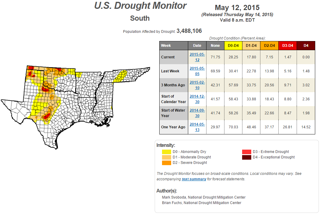
Southern Drought
Well, here's some good news! Thanks to all the recent moisture, drought conditions continue to improve across the South-Central U.S.. Get this, for the first time since July 2012, Texas is finally without EXCEPTIONAL drought conditions! Last week, nearly 2% of Texas was considered to be in an exceptional drought, now 0%
_____________________________________________
Increasing Instability: 4pm Saturday
Instability across the central part of the country looks fairly impressive by the afternoon hours Saturday. Note that there is a pretty decent amount as far north as the Upper Midwest, while the best instability looks to be across the Deep South.

Severe Threat Saturday
...SUMMARY... AT LEAST ISOLATED TO SCATTERED SEVERE STORMS ARE ANTICIPATED OVER A LARGE PORTION OF THE GREAT PLAINS. TORNADOES...LARGE HAIL...AND DAMAGING WINDS WILL BE POSSIBLE. THE GREATEST POTENTIAL FOR INTENSE SEVERE STORMS MAY EXIST OVER KANSAS AND OKLAHOMA DURING LATE AFTERNOON TO EVENING ON SATURDAY. ...SYNOPSIS... BROAD MID-LEVEL TROUGH SHOULD EXTEND FROM THE NRN ROCKIES TO THE FOUR CORNERS AREA AT 12Z/SAT WITH A FEW EMBEDDED SHORTWAVE IMPULSES. THE MOST SUBSTANTIAL IMPULSE SHOULD PROGRESS FROM AZ/NM INTO KS/NEB BY SAT NIGHT WITH A VERY STRONG MID-LEVEL JET /70-80 KT AT 500 MB/ OVERSPREADING NW TX...WRN OK AND SWRN KS DURING THE LATE AFTERNOON/EVENING. A PAIR OF SURFACE CYCLONES SHOULD DIURNALLY DEEPEN ALONG THE CO/KS BORDER AND OVER THE NRN GREAT PLAINS. A WARM FRONT WILL EXTEND E FROM THE LATTER LOW ACROSS THE UPPER MIDWEST TO GREAT LAKES. THE DRYLINE WILL ARC S FROM THE CNTRL HIGH PLAINS CYCLONE AND SHOULD BE OVERTAKEN BY A PACIFIC COLD FRONT BY SAT NIGHT. ...CNTRL/SRN GREAT PLAINS... OVERALL SYNOPTIC PATTERN SUPPORTS SOME POTENTIAL FOR A REGIONAL SEVERE WEATHER OUTBREAK...BUT CONFIDENCE IN THE EVOLUTION OF EARLY DAY CONVECTION AND ITS POSSIBLE DELETERIOUS EFFECTS ON THE DEGREE OF WARM SECTOR INSTABILITY IN THE ABSENCE OF A STRONG EML RESULTS IN DEFERRAL ON A CATEGORICAL UPGRADE THIS OUTLOOK. GUIDANCE REMAINS CONSISTENT IN SUGGESTING SCATTERED ELEVATED TSTMS OVER PARTS OF THE WARM SECTOR AT 12Z/SAT. HOWEVER...SPREAD IS LARGE IN HOW THIS ACTIVITY EVOLVES DURING THE LATE MORNING WHICH WILL BE CRITICAL TO THE DEGREE OF DIURNAL DESTABILIZATION. WITHOUT A ROBUST EML...EVEN LIMITED DIABATIC HEATING AMIDST PERVASIVE 60S SURFACE DEW POINTS IN CONJUNCTION WITH MODEST MID-LEVEL HEIGHT FALLS SHOULD SUPPORT A CONTINUATION OF THIS CONVECTION EWD TOWARDS THE LOWER PLAINS...POTENTIALLY IN THE FORM OF ONE OR MORE MCS/S. SEVERE COVERAGE SHOULD REMAIN ISOLATED WITH ANY OF THIS ACTIVITY. IN THE WAKE OF MORNING CONVECTION...AIR MASS RECOVERY IS QUITE UNCERTAIN...WITH ANYWHERE FROM A MEAGER TO MODERATELY UNSTABLE AIR MASS POSSIBLE BY LATE AFTERNOON. AS THE VERY STRONG S/SWLY MID-LEVEL JET OVERSPREADS THE DRYLINE/PACIFIC FRONT AND DCVA APPROACHES WITH THE SHORTWAVE IMPULSE CROSSING THE SRN HIGH PLAINS...DEEP ASCENT WILL BECOME LARGE. BOTH LOW-LEVEL AND DEEP SHEAR PROFILES WILL INCREASE AND BE FAVORABLE FOR SUPERCELLS...ALTHOUGH STORMS WOULD PROBABLY EVOLVE INTO LINE SEGMENTS/CLUSTERS OVER THE CNTRL PLAINS. TORNADOES AND LARGE HAIL /SOME OF WHICH MAY BE SIGNIFICANT/...AND SEVERE WIND GUSTS WILL ALL BE POSSIBLE. ...NRN GREAT PLAINS/UPPER MIDWEST... SCATTERED ELEVATED TSTMS SHOULD BE ONGOING ALONG/N OF THE ADVANCING WARM FRONT. MODERATE DESTABILIZATION IS EXPECTED IN THE WAKE OF THIS ACTIVITY AMIDST PREDOMINATELY MID 50S TO LOWER 60S SURFACE DEW POINTS. LATE DAY TSTMS SHOULD BECOME MORE NUMEROUS DURING THE EVENING AS MID-LEVEL HEIGHT FALLS/DCVA INCREASE. WIND PROFILES SHOULD LARGELY BE UNIDIRECTIONAL SUPPORTING A CLUSTER MODE WITH A MIX OF SEVERE HAIL/WIND. A CONDITIONAL RISK FOR A COUPLE TORNADIC SUPERCELLS MAY DEVELOP NEAR THE WARM FRONT WHERE 0-1 KM WINDS ARE BACKED MAINLY FROM CNTRL ND TO THE RED RIVER VALLEY.

Increasing Instability: 4pm Sunday
Instability on Sunday doesn't look quite as far north or as impressive as it does on Saturday, but there's still plenty for a few strong to severe storms across parts of the Midwest.

Severe Threat Sunday
...SYNOPSIS... A VIGOROUS SHORTWAVE IMPULSE EXPECTED TO BE NEAR THE MID-MO VALLEY AT 12Z/SUN SHOULD PROGRESS N/NE INTO THE UPPER MS VALLEY SUN AFTERNOON/EVENING AND THEN SLOWLY DRIFT E. AS THIS OCCURS...OCCLUDING SURFACE CYCLONE OVER THE UPPER MIDWEST WILL UNDERGO CYCLOLYSIS SUN NIGHT. COMPOSITE DRYLINE/PACIFIC FRONT SHOULD ADVANCE INTO IA TO THE SRN GREAT PLAINS BEFORE STALLING...AS A MORE ROBUST COLD FRONT SURGES SE AND REACHES THE LOWER MO VALLEY TO SRN HIGH PLAINS BY 12Z/MON. ...MID/UPPER MS VALLEY... ALTHOUGH AN INITIALLY INTENSE MID-LEVEL JET SHOULD BE IN THE PROCESS OF WEAKENING DURING THE PERIOD...STRONG EFFECTIVE SHEAR SHOULD BE MAINTAINED THROUGH THE DIURNAL HEATING CYCLE. UNCERTAINTY EXISTS OVER THE DEGREE OF DESTABILIZATION IN THE WAKE OF LIKELY EARLY-DAY STORMS AND EXTENSIVE UPSTREAM CONVECTION ON D2. IN ADDITION...FORECAST SOUNDINGS DEPICT PERVASIVE VEER-BACK WIND PROFILES SIGNATURES IN THE MID/UPPER-LEVELS GIVEN THE OCCLUDING NATURE OF THE DEEP CYCLONE. GUIDANCE DIFFERS IN TIMING THE ASCENT ASSOCIATED WITH THE SHORTWAVE IMPULSE...SUGGESTING THAT AFTERNOON CONVECTIVE COVERAGE MIGHT REMAIN SPARSE S OF THE UPPER MS VALLEY. AS SUCH...WILL MAINTAIN SLIGHT RISK THIS OUTLOOK. ...MID-SOUTH TO SRN GREAT PLAINS... LESS ORGANIZED MULTICELL TSTMS SHOULD DEVELOP ALONG REMNANT CONVECTIVE OUTFLOW FROM D2 CONVECTION AND PERHAPS ALONG THE DRYLINE. LACK OF GREATER FORCED ASCENT AND WEAKENING FLOW FIELDS DURING THE DAY SUGGEST THE RISK FOR SEVERE STORMS WILL BE COMPARATIVELY MARGINAL TO FARTHER N.

______________________________________
Snow in Arizona?
This was the view from Flagstaff, AZ Friday morning as a storm system was moving through the Western U.S.. Interestingly, this storm system is the same one that will bring us warm, somewhat muggy and unsettled weather this weekend.

______________________________________
Meet Lily
Now this is pretty slick! If you're in to taking selfies, this might be the ultimate selfie! A drone video camera that will follow you!
"Lily is a self-flying drone that is always following you, following a certain set of commands. It follows a small circular tracker, which you can have in your pocket or on your boat. With one tap of the tracker, Lily can execute some nifty camera moves, all while staying focused on you. The camera inside, Bradlow says, is roughly equivalent to the GoPro Hero 3: It can shoot 1080p video, or 720p up to 120 frames per second—there’s some tech inside that will detect when you hit a jump while snowboarding and automatically kick the camera into slow-mo. It’ll also shoot 12-megapixel stills and it can make a cool 360-degree panorama. It can fly 25 miles per hour, is totally waterproof, lasts up to 20 minutes on a charge, and has range up to 100 feet. Bradlow says it could move faster and have more range, but the point isn’t to map agricultural landscapes—it’s to take pictures, or have the Lily chase you down the slopes while you carve some powder."

_____________________________________________
Thanks for checking in and have a great weekend ahead! Don't forget to follow me on Twitter @TNelsonWX

No comments:
Post a Comment