
Filling Up
By Todd Nelson
As I get older, I am finding that there's not enough time. From accomplishing day to day tasks to finding open spots on an already full calendar, I sometimes wonder how it all gets done. While the key to success often means being a good time manager, I often find that tackling tasks with optimism and drive makes that mountain a little less hard to climb.
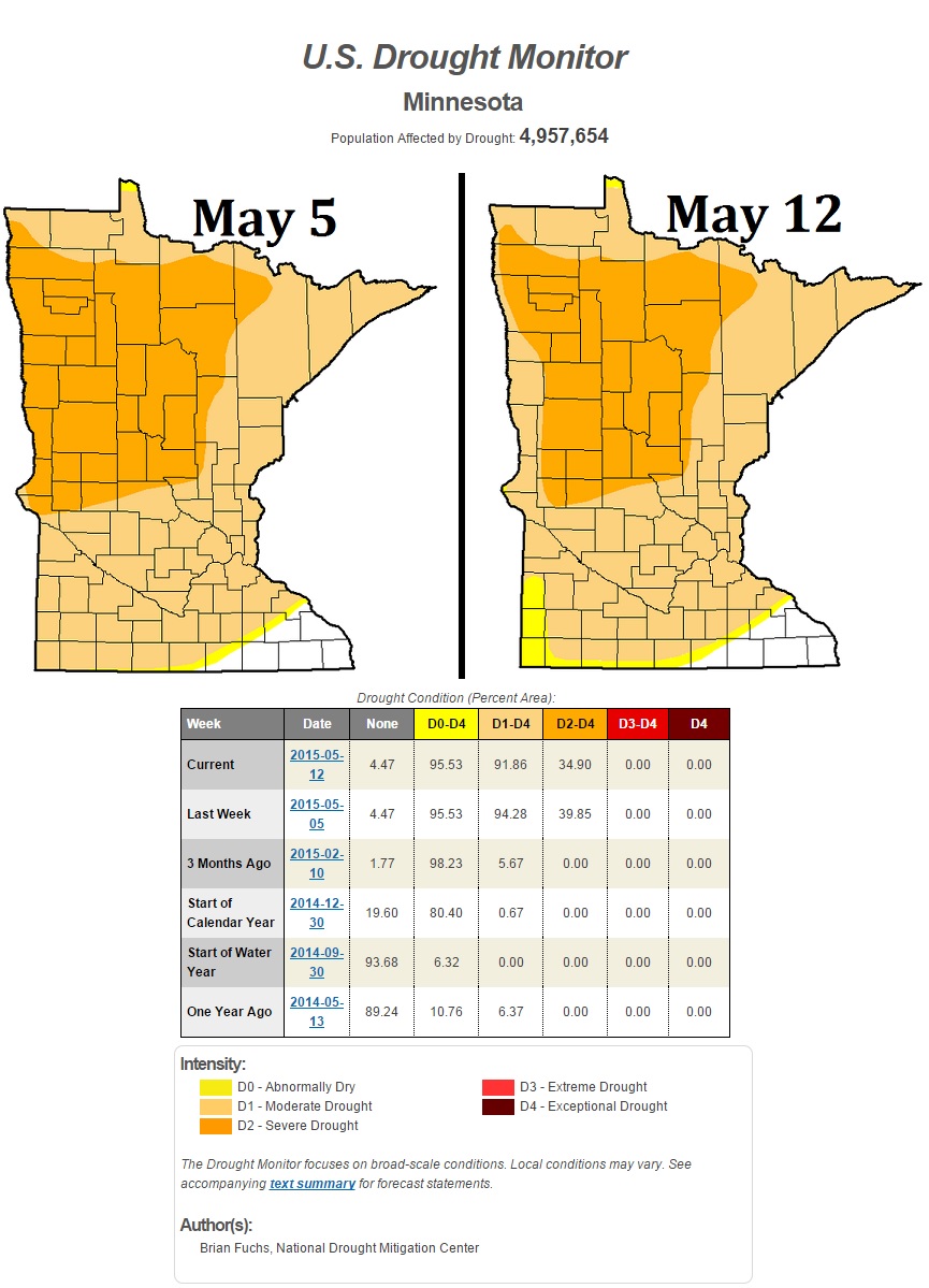
While our calendars are filling up, our rain gauges are doing the same. Radar estimates show that nearly 1 to 4 inches of rain has fallen across the state since the first of the month. However, the U.S. Drought Monitor showed minimal improvement in the state's drought since last week. We've gone from 94 to 92 percent moderate drought and from 40 to 35 percent severe drought. With additional heavy rainfall still possible into the upcoming weekend, I expect additional improvement in those numbers by next week.
After a soggy start today, weather conditions will be warmer and drier by the afternoon. Our next storm system blows into town this weekend with strong to severe thunderstorm chances late Saturday and again Sunday. Keep an eye on the forecast for potential watches and warnings near you.
_____________________
THURSDAY NIGHT: Rain early, then mostly cloudy. Low: 51. Winds: SE 5-10 turning W.
FRIDAY: Soggy start. Warmer and drier afternoon. High: 72.Wind: WNW 5, turning NNE
FRIDAY NIGHT: Increasing clouds, chance of a shower or storm by early morning. Low: 59. Wind: ESE 5.
SATURDAY: A few spotty showers/storms possible early. Otherwise, breezy and mild with strong storms developing late. High: near 80. Winds: SSE 10-20.
SUNDAY: Scattered showers and storms. A few heavy downpours. Wake-up: 64. High: 76.
MONDAY: Gradual clearing. Breezy and cooler. Wake-up: 48. High: 57.
TUESDAY: Bright sun, less wind. Wake-up: 42. High: 63.
WEDNESDAY: Spotty PM shower or storm south. Wake-up: 44. High: 63.
THURSDAY: Mix of sun and clouds. Wake-up: 47. High: 67.
_______________________
This Day in Weather History
May 15th
1998: Severe thunderstorms hit many areas of Minnesota. Baseball-sized hail caused damage at International Falls. A tornado hit a flea market in Albany, killing one person. 30 people were injured. 102 homes severely damaged in the northern Twin Cities due to another tornado.
1969: Storm in Synnes township dumps 8 inches of rain in three hours.
_______________________
Average High/Low for Minneapolis
May 15th
Average High: 69F (Record: 94F set in 2001)
Average Low: 49F (Record: 31F set in 1980)
_________________________
Sunrise/Sunset Times for Minneapolis
May 15th
Sunrise: 5:44am
Sunset: 8:35pm
__________________________
Moon Phase for May 15th at Midnight
1.9 Days Before New Moon

_________________________________
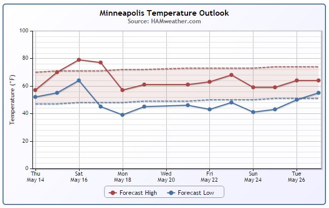
Minneapolis Temperature Trend
After a cool and soggy Thursday, weather conditions will improve Friday as warmer, drier weather moves in. We'll continue our warming trend as we head into the weekened with highs approaching 80F! The storm system responsible for our warming this weekend will also bring a chance of strong to severe storms with it. Post storm system, it appears we cool down again into next week. I am hoping we warm up and dry out by Memorial Weekend; I've got some grilling to do!
_________________________________
Friday Weather Outlook
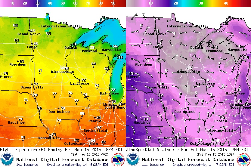
Temperatures will be feel quite a bit warmer on Friday after the cool, soggy Thursday we had. The best chance of highs reaching 70F or better will be across the southern half of the state, while highs in the northern part of the state look to still be stuck in the low/mid 60s.
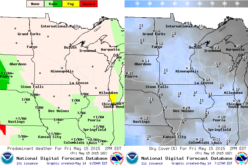
Friday Weather Outlook
Friday may start on a soggy/puddly note, but with a little clearing and some sunshine, we should be able to dry out a little through the day. Enjoy it because weather conditions look to turn unsettled into the weekend. Although it looks warmer, strong to severe storms may be rolling into town!
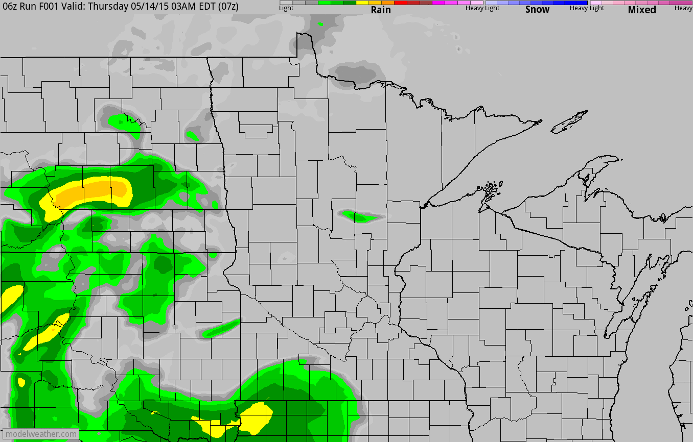
Simulated Radar
The simulated radar loop below from AM Thursday through PM Saturday shows the soggy weather Thursday giving way to drier weather Friday, then some unsettled weather developing later Saturday. Keep an eye on the forecast over the weekend and strong to severe storms could pop up close to home.
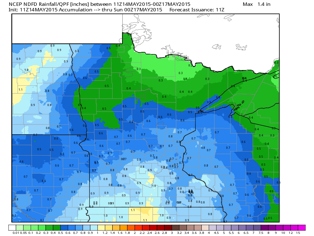
Rainfall Potential
The image below from suggests nearly 0.5" to 1.0" of rain possible from AM Thursday to PM Saturday.
_____________________________________________
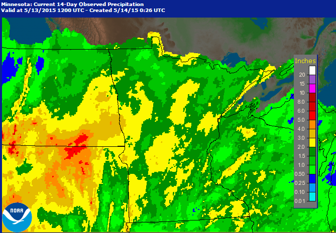
Rainfall Past 14 Days
Radar estimated rainfall through the first 14 days of the month suggest that we've seen nearly 2" to 4" of rain in parts of central Minnesota.
_____________________________________________
Minnesota Drought Update
The latest update from the U.S. Drought Monitor show a slight improvement since last week. The MODERATE drought area dropped from near 94% to 92% and the severe drought dropped from 40% to 35%
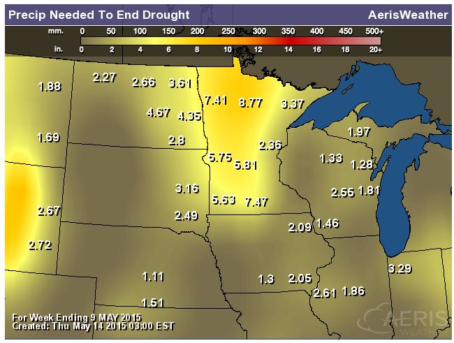
Rain Needed to End Drought
Interestingly, parts of the state still need nearly 5" to 7"+ to end the drought. The good news is that additional heavy rainfall amounts may still be on the way over the weekend.
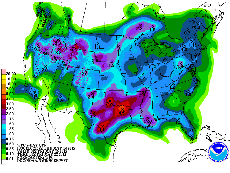
7 Day Precipitation Outlook
According to NOAA's HPC. the 7 day precipitation outlook still shows some impressive tallies across parts of the Central U.S. Through midweek next week, as much as 2" to 4" amounts can't be ruled out!
______________________________________________
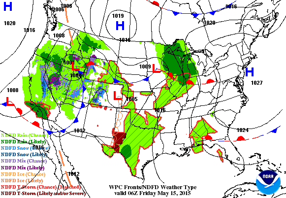
National Weather Outlook
Our next storm system across the Western U.S. will continue moving east through into the upcoming weekend. After a few quiet days, severe weather, heavy rain and flooding potential looks to ramp back up over the next few days.
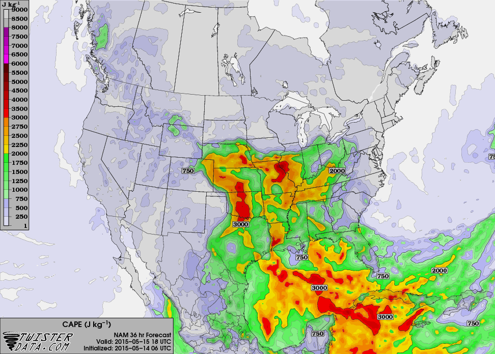
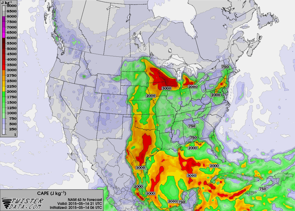
Increasing Instability: CAPE Friday 1pm
This is a look at the instability by early afternoon Friday. Note the oranges and reds across parts of the Plains and middle part of the country. This is where thunderstorms activity would have the best potential to become strong to severe if they do develop.
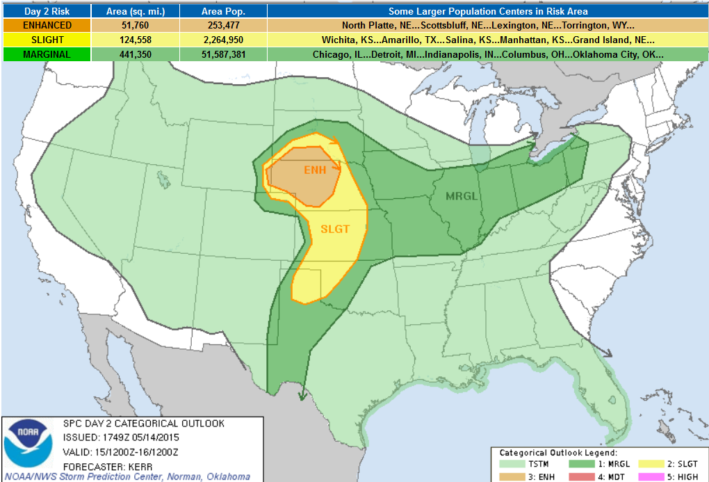
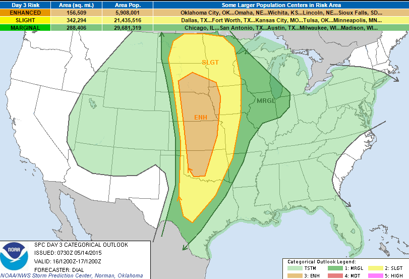
Severe Threat Friday
...SUMMARY... SEVERE THUNDERSTORMS ARE EXPECTED ACROSS PARTS OF THE NORTH CENTRAL HIGH PLAINS FRIDAY AFTERNOON AND EVENING. MORE ISOLATED SEVERE STORM DEVELOPMENT IS POSSIBLE SOUTHWARD INTO THE SOUTHERN HIGH PLAINS BY FRIDAY EVENING. OTHER SCATTERED STRONG TO SEVERE STORMS ARE POSSIBLE FRIDAY ACROSS PARTS OF THE MIDDLE MISSISSIPPI VALLEY INTO SOUTHERN PORTIONS OF THE GREAT LAKES REGION. ...SYNOPSIS... A SPLIT IN THE MID-LATITUDE WESTERLIES WILL PERSIST ACROSS THE NORTHEASTERN PACIFIC THROUGH THIS PERIOD...WITH MODELS SUGGESTING AN UPPER HIGH CENTER BECOMING INCREASINGLY PROMINENT OVER NORTHERN BRITISH COLUMBIA AND THE YUKON TERRITORY. WITHIN THE SOUTHERN STREAM...TO THE SOUTH OF THE RIDGE...CYCLONIC MID/UPPER FLOW MAY BROADEN ACROSS PARTS OF THE EASTERN PACIFIC THROUGH MUCH OF THE U.S. PLAINS BY 12Z SATURDAY. ONE OF THE MORE SIGNIFICANT EMBEDDED SHORT WAVE IMPULSES APPEARS LIKELY TO GRADUALLY PIVOT FROM THE EASTERN GREAT BASIN THROUGH THE NORTHERN HIGH PLAINS FRIDAY THROUGH FRIDAY NIGHT. AT THE SAME TIME...THE PRIMARY/STRONGER PERTURBATION...COMING INCREASINGLY IN PHASE WITH THE SUBTROPICAL STREAM...IS EXPECTED TO PROGRESS INLAND ACROSS SOUTHERN CALIFORNIA/NORTHERN BAJA DURING THE DAY...BEFORE CONTINUING EAST OF THE LOWER COLORADO VALLEY...TOWARD THE SOUTHERN ROCKIES...FRIDAY NIGHT. AROUND THE NORTHERN PERIPHERY OF DOWNSTREAM AMPLIFYING LARGE-SCALE RIDGING...ANOTHER SUBSTANTIVE SHORT WAVE TROUGH PROBABLY WILL TRACK FROM THE GREAT LAKES REGION THROUGH MUCH OF THE NORTHEAST. IN LOWER-LEVELS...A SURFACE FRONTAL ZONE APPEARS LIKELY TO TEND TO SHIFT NORTHWARD ACROSS THE NORTHERN TIER STATES...TO THE EAST OF THE ROCKIES...MORE RAPIDLY THROUGH THE NORTHERN PLAINS AND UPPER MIDWEST THAN THE LOWER GREAT LAKES REGION. SURFACE TROUGHING WILL PROBABLY CONTINUE TO DEEPEN TO THE LEE OF THE ROCKIES...WITH MODELS INDICATING A CONSOLIDATING/DEEPENING LOW CENTER OVER THE NORTHERN HIGH PLAINS BY THE END OF THE FORECAST PERIOD. EAST OF THE SURFACE TROUGH...AND ALONG/SOUTH OF THE FRONT...LOWER LEVELS ARE EXPECTED TO CONTINUE TO MOISTEN ON SOUTHERLY FLOW. BY LATE FRIDAY AFTERNOON...INSOLATION IS EXPECTED TO BE SUFFICIENT TO SUPPORT CORRIDORS OF MODEST BOUNDARY LAYER DESTABILIZATION /CHARACTERIZED BY CAPE OF 1000-2000 J PER KG/ ACROSS PARTS OF THE HIGH PLAINS...AND ACROSS PORTIONS OF THE MIDDLE MISSISSIPPI VALLEY THROUGH SOUTHERN PORTIONS OF THE GREAT LAKES REGION. MEANWHILE...STRONGEST VERTICAL SHEAR SHOULD BECOME FOCUSED ACROSS THE NORTH CENTRAL HIGH PLAINS. HOWEVER...MODEST WESTERLY DEEP LAYER FLOW/SHEAR MAY DEVELOP WITH THE UPPER IMPULSE...NEAR THE FRONT...ACROSS THE SOUTHERN GREAT LAKES REGION...PERHAPS ALSO WITH ANOTHER WEAK IMPULSE CROSSING THE MIDDLE MISSISSIPPI VALLEY. ...HIGH PLAINS... MOISTENING EASTERLY/SOUTHEASTERLY LOW-LEVEL UPSLOPE FLOW...TO THE NORTHEAST OF A DAYTIME SURFACE LOW CENTER OVER NORTHEAST COLORADO...IS EXPECTED TO HELP FOCUS PRIMARY STORM DEVELOPMENT ACROSS THE NORTH CENTRAL HIGH PLAINS FRIDAY AFTERNOON. THIS SHOULD BE AIDED BY MID/UPPER FORCING ASSOCIATED WITH THE LEAD IMPULSE MIGRATING OUT OF THE EASTERN GREAT BASIN...WHICH COULD CONTRIBUTE TO THE INITIATION OF VIGOROUS STORMS ACROSS PARTS OF NORTHEAST COLORADO/SOUTHEAST WYOMING AS EARLY AS MIDDAY. ACTIVITY SHOULD THEN DEVELOP/SPREAD NORTHWARD/NORTH NORTHEASTWARD THROUGH MUCH OF WESTERN AND CENTRAL NEBRASKA AND SOUTHERN SOUTH DAKOTA THROUGH THE REMAINDER OF THE AFTERNOON AND EVENING HOURS. IN THE PRESENCE OF STRONG DEEP LAYER SHEAR...AND SIZABLE CLOCKWISE CURVED LOW-LEVEL HODOGRAPHS...ORGANIZED CONVECTION...INCLUDING SUPERCELLS...WILL SUPPORT THE RISK FOR SEVERE HAIL AND A FEW TORNADOES INITIALLY...BEFORE THE RISK OF DAMAGING WIND GUSTS BECOMES MORE PROMINENT FRIDAY EVENING. ISOLATED SUPERCELLS MAY ALSO NOT BE OUT OF THE QUESTION ALONG THE DRYLINE SOUTHWARD THROUGH THE CENTRAL AND SOUTHERN HIGH PLAINS LATE FRIDAY AFTERNOON AND EVENING. BUT PRIMARY THUNDERSTORM DEVELOPMENT MAY AWAIT FORCING WITH THE STRONGER UPSTREAM IMPULSE...WHICH MAY NOT OCCUR UNTIL LATE FRIDAY NIGHT.
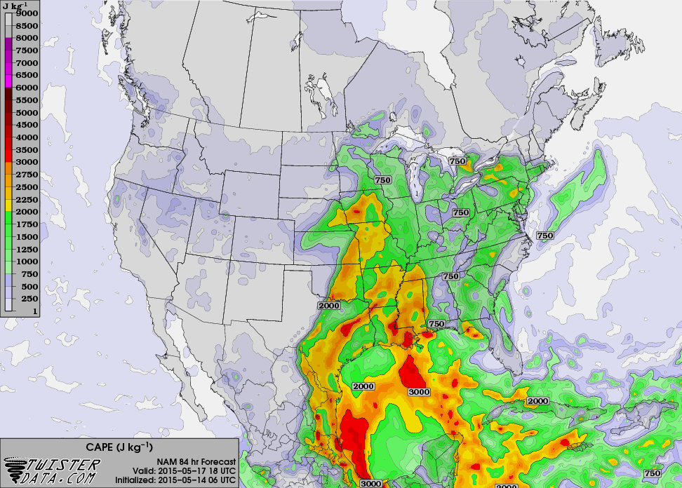
Increasing Instability: CAPE Saturday 4pm
Instability across middle part of the country really starts to increase by the afternoon/evening hours on Saturday. At this point, Saturday could be a fairly interesting day with several areas possibly seeing strong to severe thunderstorm development.
Severe Threat Saturday
...SUMMARY... POTENTIAL FOR NUMEROUS STRONG TO SEVERE STORMS WILL EXIST SATURDAY OVER A LARGE PART OF THE PLAINS INTO A PORTION OF THE MIDDLE AND UPPER MISSISSIPPI VALLEY REGIONS. LARGE HAIL...DAMAGING WIND AND A FEW TORNADOES WILL BE POSSIBLE. ...CNTRL THROUGH SRN PLAINS AREA... EARLY SATURDAY A WARM FRONT SHOULD EXTEND EWD FROM A SFC LOW OVER THE NRN HIGH PLAINS THROUGH SD...MN AND SRN WI. A DRYLINE/PACIFIC FRONT WILL EXTEND SWD FROM THIS LOW THROUGH THE HIGH PLAINS INTO WRN TX. MOIST WARM SECTOR WILL BE IN PLACE EAST OF DRYLINE/PACIFIC FRONT WITH DEWPOINTS FROM THE UPPER 60S OVER TX AND OK TO THE LOW 60S FARTHER NORTH INTO SD. POTENTIAL FOR EARLY CONVECTION AND AREAS OF WIDESPREAD CLOUDS REMAIN A COMPLICATING FACTOR THIS FORECAST. AN AREA OF MOSTLY ELEVATED THUNDERSTORMS MAY BE ONGOING SATURDAY OVER A PORTION OF THE CNTRL AND SRN PLAINS WARM SECTOR...AND THIS ACTIVITY WILL SHIFT EWD DURING THE MORNING. IN WAKE OF EARLY STORMS...A CORRIDOR OF MODERATE INSTABILITY SHOULD DEVELOP AHEAD OF THE PACIFIC FRONT...AND ADDITIONAL STORMS WILL LIKELY INITIATE ALONG AND AHEAD OF THIS BOUNDARY AS A STRONG UPPER JET SWINGS THROUGH BASE OF TROUGH...AUGMENTING DEEP ASCENT. BOTH LOW-LEVEL AND DEEP SHEAR PROFILES WILL INCREASE DURING THE DAY WITH THE APPROACH OF THE UPPER JET...BECOMING FAVORABLE FOR ORGANIZED STORMS INCLUDING SUPERCELLS BY AFTERNOON...THOUGH SOME STORMS MAY ALSO EVOLVE INTO LINE SEGMENTS AND CLUSTERS. LARGE HAIL...DAMAGING WIND AND A FEW TORNADOES WILL BE POSSIBLE WITH THIS ACTIVITY. ...NRN PLAINS THROUGH UPPER MS VALLEY... ELEVATED STORMS MAY BE ONGOING IN VICINITY OF WARM FRONT AS IT LIFTS NWD THROUGH THE DAKOTAS AND MN DURING THE DAY. THE ATMOSPHERE IS EXPECTED TO DESTABILIZE IN WAKE OF THIS ACTIVITY AND ADDITIONAL STORMS WILL LIKELY DEVELOP NEAR TRIPLE POINT OVER WRN/CNTRL ND AND SWWD ALONG PACIFIC FRONT/DRYLINE. STRONGEST LOW-LEVEL SHEAR WILL EXIST IN VICINITY OF WARM FRONT WHERE A CONDITIONAL RISK WILL EXIST FOR A FEW TORNADIC SUPERCELLS. OTHERWISE...PRIMARY THREAT WILL BE DAMAGING WIND AND HAIL FROM MID AFTERNOON INTO THE EARLY EVENING.
Increasing Instability: CAPE Sunday 1pm
While not quite as impressive as Friday and Saturday, the instability by midday Sunday still looks fairly impressive across the middle part of the country once again.
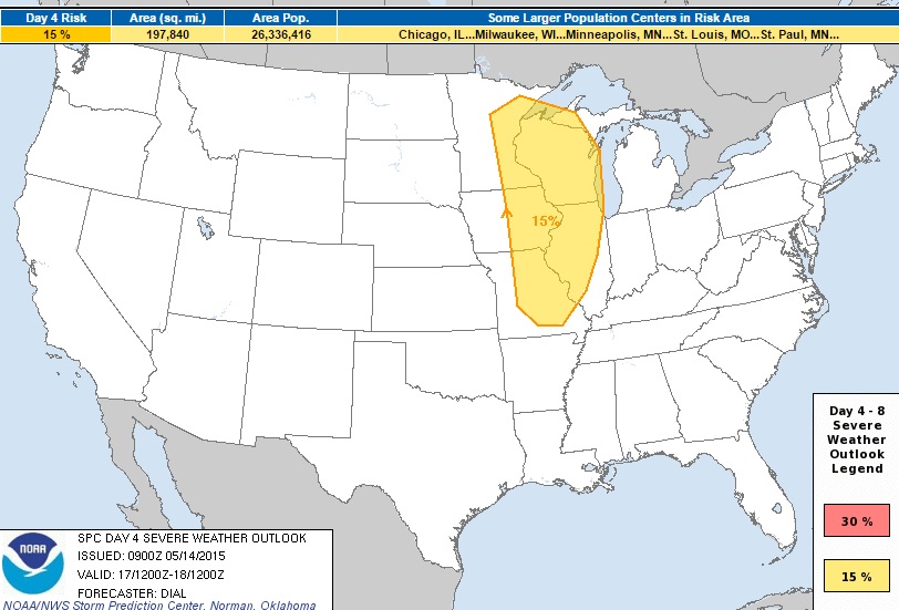
Severe Threat Sunday
SUNDAY: SEVERE THREAT WILL SHIFT INTO THE MIDDLE AND UPPER MS VALLEY AND GREAT LAKES REGION IN ASSOCIATION WITH A PROGRESSIVE UPPER TROUGH AND ITS ATTENDANT STRONG DEEP-LAYER WIND PROFILES. THE LIKELIHOOD OF ONGOING STORMS RAISES UNCERTAINTY REGARDING WHERE THE HIGHER SEVERE POTENTIAL WILL EVOLVE...SO WILL MAINTAIN GENERIC 15% SEVERE PROBABILITY THIS UPDATE. FARTHER SOUTH...LESS ORGANIZED MULTICELL STORMS WILL DEVELOP THROUGH ERN TX WARM SECTOR WHERE THE THERMODYNAMIC ENVIRONMENT MAY SUPPORT AT LEAST A MODEST RISK FOR SEVERE STORMS.
_______________________________________
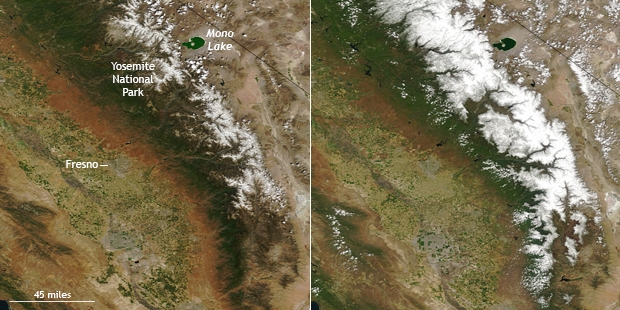
Sierra Nevada Snow Deficit
"Few things are more important to California’s water supply than the water content of the mountain snowpack at the start of the state’s warm season. Winter-type storms and snowfall tend to taper off in April and May. Temperatures become warmer and days become longer, causing the snowpack to melt. As spring turns to summer, this melting snow keeps the state’s rivers and streams—and people’s farms, fields, and taps—from running dry."
"The snowpack this spring is incredibly small. These photo-like NASA satellite images contrast the snow extent in the Southern Sierra Nevada Range Mountains on May 2, 2015, and May 10, 2003, a year when snow conditions were close to the long-term average. (The large versions of the images show the entire state.) Instead of gleaming white snow tracing ridges and valleys, large areas of bare brown rock appear on the mountain summits in the 2015 image."
See more from Climate.gov HERE:
_________________________________________
"Climate Denialists In Congress Acting As NASA's Kryptonite"
"Quick: List the first four words that pop into your mind when you hear NASA.
If you are like most folks, you hit some mix of astronauts, moon landings, space telescopes and Mars probes. Those are pretty positive images representing accomplishments we can all feel proud about.
Astronauts are, after all, great American heroes. And space telescopes are reminders of just how smart — and insanely capable — Americans can be. Put it all together and you can see why NASA does superhero stuff in the eyes of most people.
It's also stuff that's universally recognized to be the kind where you absolutely, positively can't afford to be wrong. And that is why NASA is a real problem for climate denialism.
If you are intent on convincing people there is no climate change, then the last thing you want is NASA — with all its heroism and accuracy — telling folks climate change is real. So, faced with this dilemma, climate denialist's have come up with a clever solution: Get NASA out of climate change science."
See more from NPR.org HERE:
(Image credit: NASA)
_____________________________________________
Thanks for checking in and have a great rest of your week and weekend ahead. Don't forget to follow me on Twitter @TNelsonWX

No comments:
Post a Comment