___________________________________________________________________
Dueling Warnings
By Paul Douglas
Competitive pressures in the media world may still lead to a scenario where local TV stations issue their own storm warnings, which would be an unmitigated mess. It almost happened in the 90s, when live Doppler radar was coming on the scene.
Who cares? Research shows that when the public receives conflicting information they are more likely to do nothing. They don't seek shelter. But when the media speaks with one voice, when everyone's on the same page, the potential for confusion goes down.
Next Wednesday is the 50th anniversary of the 1965 tornado super-outbreak. There were four EF-4 tornadoes in the metro area; something that hasn't happened since - a blunt reminder that Minnesota can experience large, violent, Texas-size twisters. Make sure you have a NOAA Weather Radio; still the cheapest life insurance you can buy.
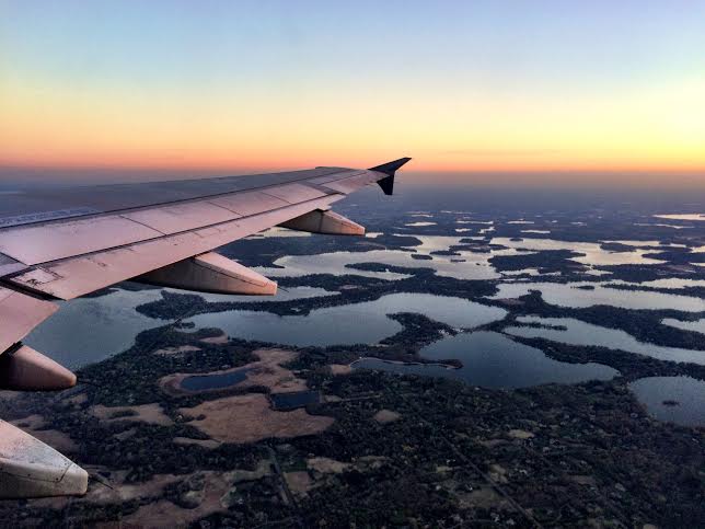
Today will be the better day of the weekend to putter around in the yard (it's good to wait until Mother's Day to plant annuals, but the risk of another killing freeze is very low). We should hit 80F today; a few strong T-storms late Sunday, then a soaking rain (1-2 inches) by the middle of next week.
I'm expecting a long, hot summer. Let it rain.
_________________________________________________________
FRIDAY NIGHT: Partial clearing. Low: 53
SATURDAY: Sunnier, drier day of the weekend, mild breeze. Winds: South 5-15. High: 81
SATURDAY NIGHT: Mostly clear, mild and quiet. Low: 60.
SUNDAY: PM T-storms, strong to severe? High: 74
MONDAY: Partly sunny, drying out. Wake-up: 50. High: 70
TUESDAY: Clouding up, showers arrive late. Wake-up: 49. High: 72
WEDNESDAY: Heavier showers, few T-storms. Wake-up: 55. High: 74
THURSDAY: Showers and storms, locally heavy rain. Wake-up: 60. High: 75
FRIDAY: Clearing skies, pleasant. Wake-up: 50. High: 68.
_________________________________________________________
This Day in Weather History
May 2nd
1954: Late season snowstorm dumps over half a foot of snow at International Falls.
_________________________________________________________
Average High/Low for Minneapolis
May 2nd
Average High: 65F (Record: 91F set in 1959)
Average Low: 44F (Record: 24F set in 1961)
_________________________________________________________
Sunrise/Sunset Times for Minneapolis
May 2nd
Sunrise: 6:01am
Sunset: 8:20pm
_________________________________________________________
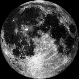
Moon Phase for May 2nd at Midnight
0.9 Days Before Full (Flower) Moon
_________________________________________________________
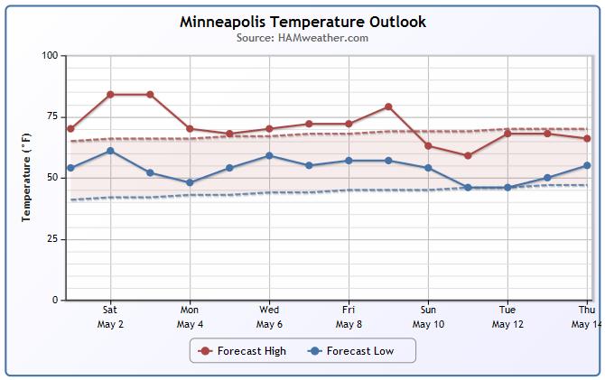
Minneapolis Temperature Trend
June-like temperatures will be with us this weekend with highs around 80F. We take a little tumble into the 70s early next week, but it appears that temperatures will still be slightly above average through the first part of May. By the way, April finished 2.2 degrees above average and May is already off to a very warm start!
_________________________________________________________
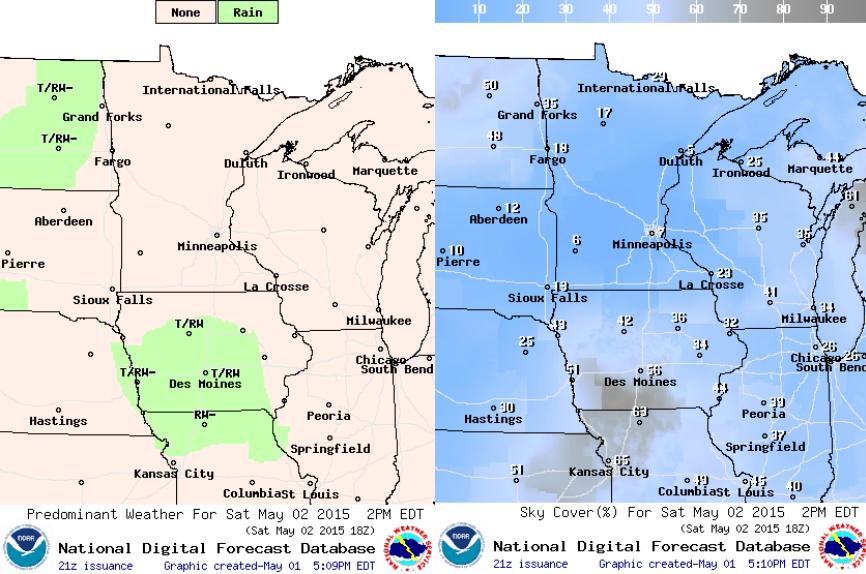
Saturday Outlook
Weather conditions on Saturday will be quite mild across much of the state and region! Widespread 70s and 80s will make it feel a little more like early June than early May. A south wind will pick a up a little later in the day with the strongest winds likely to occur across the Red River Valley with wind gusts up to 30mph.
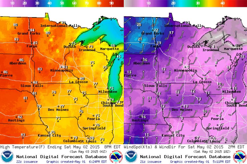
Saturday Weather Outlook
It'll be an incredibly springy Saturday across the state and region with early June-like temperatures and mostly sunny skies! There may be a few late day showers or thundershowers across parts of Iowa and North Dakota, but much of Minnesota will stay quiet.
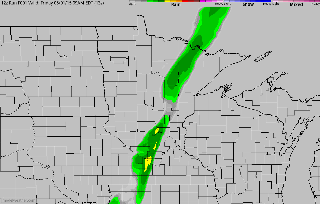
Increasing Late Day Thunder Chances Sunday
The simulated radar below from AM Friday through PM Sunday shows our brief rain that we had on Friday. Unfortunately, we only picked up 0.01" of rain (officially at MSP), which puts us nearly 2.5" below average precipitation since January 1st. Hopefully we pick up some decent downpours on Sunday afternoon/evening as our cool front pushes through.
________________________________________________________________
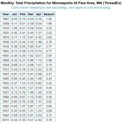
23rd Driest Start to the Year in Minneapolis
January - April at Minneapolis only saw 3.78" of precipitation. Interestingly, this is the 23rd driest start to the year on record!
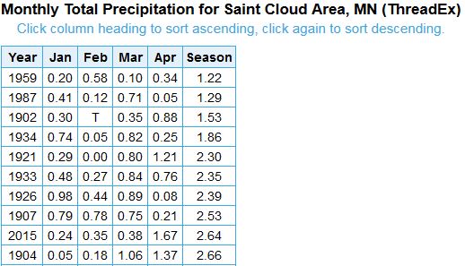
9th Driest Start to the Year in St. Cloud
January - April at St. Cloud only saw 2.64" of precipitation, which makes it the 9th driest start to the year in St. Cloud on record.
________________________________________________________________
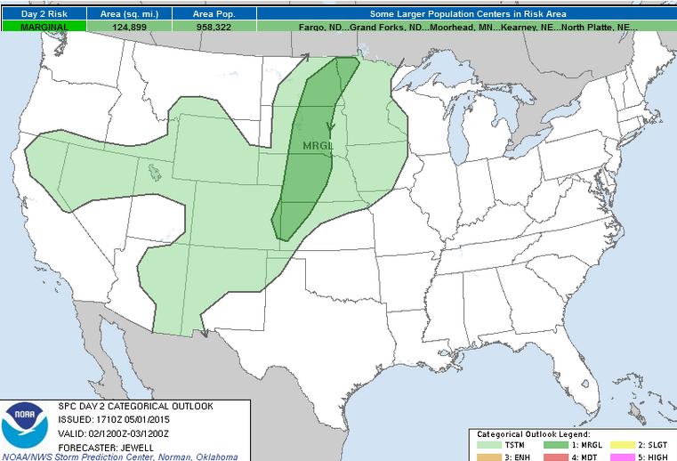
Severe Threat Saturday
...SUMMARY...
ISOLATED STRONG STORMS ARE EXPECTED SATURDAY ACROSS PARTS OF THE
NORTHERN AND CENTRAL PLAINS. MARGINALLY SEVERE HAIL AND WIND WILL BE
POSSIBLE.
...SYNOPSIS AND DISCUSSION...
INCREASING WLY FLOW ALOFT WILL SPREAD ACROSS THE NRN PLAINS NEAR THE
BASE OF A BROAD...LOW-AMPLITUDE TROUGH OVER SRN CANADA. AT THE
SURFACE...A LOW PRESSURE TROUGH IS FORECAST TO EXTEND FROM THE CNTRL
DAKOTAS INTO WRN NEB/ERN CO BY LATE AFTERNOON. A LARGE SURFACE HIGH
OVER THE SERN U.S. WILL RESULT IN WEAK MOISTURE RETURN ACROSS THE
PLAINS WITH ONLY 40S F DEWPOINTS EXPECTED NEAR THE SFC TROUGH.
A FEW STORMS ON THE NOSE OF THE NOCTURNAL LOW-LEVEL JET ARE EXPECTED
TO BE ONGOING EARLY IN THE DAY FROM ERN NEB INTO IA AND COULD POSE A
MARGINAL HAIL THREAT INTO THE MORNING HOURS. HOWEVER...THE GREATEST
THREAT FOR SEVERE HAIL AND WIND WILL BE WITH THE DIURNAL STORMS
ALONG THE TROUGH FROM ERN ND INTO WRN KS/ERN CO. STRONG HEATING WILL
LEAD TO STEEP LAPSE RATES THROUGH A DEEP LAYER...WITH SUFFICIENT
SHEAR FOR A FEW ORGANIZED STORMS ESPECIALLY OVER THE ERN DAKOTAS
INTO NWRN MN WHERE FORCING FOR ASCENT AND SHEAR WILL BE STRONGEST.
THE LIMITING FACTOR FOR A GREATER SEVERE RISK WILL BE MOISTURE AND
INSTABILITY.
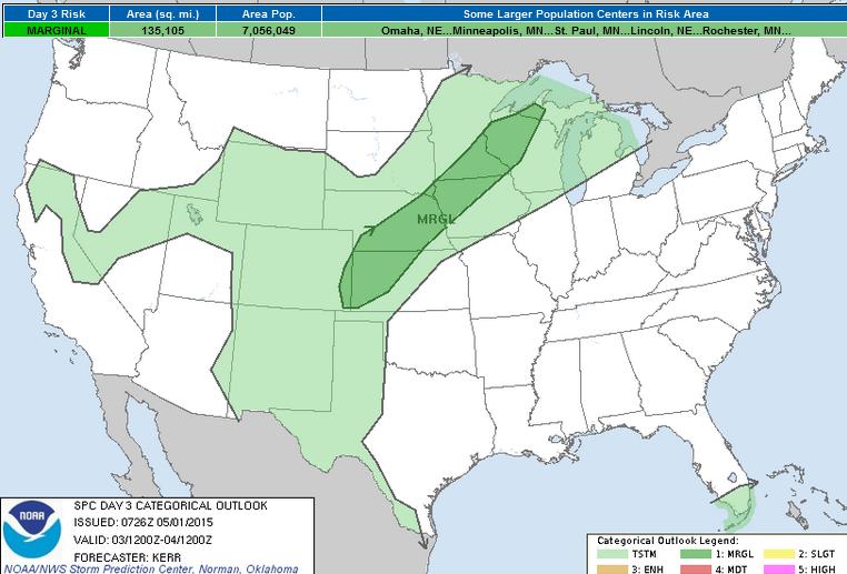
Severe Threat Sunday
...SUMMARY...
ISOLATED TO WIDELY SCATTERED STRONG STORMS ARE EXPECTED SUNDAY
WITHIN A CORRIDOR FROM THE UPPER MIDWEST INTO THE MIDDLE MISSOURI
VALLEY AND CENTRAL PLAINS. SOME OF THESE COULD BECOME CAPABLE OF
PRODUCING MARGINALLY SEVERE HAIL AND LOCALIZED STRONG WIND GUSTS.
...SYNOPSIS...
LITTLE CHANGE IN THE LARGE-SCALE UPPER PATTERN IS ANTICIPATED FROM
SATURDAY INTO SUNDAY. THE STRONGEST BRANCH OF SPLIT WESTERLIES
EMANATING FROM THE MID-LATITUDE PACIFIC WILL REMAIN LARGELY
ZONAL...AND GENERALLY CONFINED TO LATITUDES NEAR THE CANADIAN/U.S.
BORDER. AT THE SAME TIME...SEASONABLY STRONG MID/UPPER FLOW
ASSOCIATED WITH THE SUBTROPICAL WESTERLIES IS EXPECTED TO REMAIN
CONFINED TO AN ANTICYCLONIC BAND ACROSS BAJA AND NORTHERN
MEXICO...PERHAPS EDGING EASTWARD INTO THE RIO GRANDE VALLEY.
MODEL OUTPUT CONTINUES TO EXHIBIT DIFFERENCES CONCERNING THE PRIMARY
CYCLONE ASSOCIATED WITH THE MID-LATITUDE WESTERLIES...WHICH MAY
CONTINUE TO TRACK NORTHEASTWARD ACROSS SOUTHERN HUDSON BAY DURING
THIS PERIOD. THE SPREAD ALSO APPEARS TO INCREASE CONCERNING
SUBSEQUENT DEVELOPMENT OF THE SECONDARY SURFACE LOW THAT IS EXPECTED
TO FORM WITHIN LEE SURFACE TROUGHING ACROSS WESTERN SOUTH DAKOTA ON
SATURDAY. HOWEVER...IN GENERAL...THE COLD FRONT TRAILING FROM THE
PRIMARY CYCLONE IS EXPECTED TO CONTINUE ADVANCING SOUTHEAST OF THE
NORTHERN U.S. PLAINS...THROUGH THE UPPER MIDWEST/GREAT LAKES AND
PARTS OF THE CENTRAL PLAINS BY 12Z MONDAY.
MEANWHILE...SURFACE RIDGING...EXTENDING WEST SOUTHWESTWARD FROM A
SURFACE HIGH CENTER SHIFTING EAST OF THE ATLANTIC COAST...IS
EXPECTED TO REMAIN PROMINENT INLAND OF THE WESTERN AND CENTRAL GULF
COAST. AS THIS MAINTAINS ITS PRESENCE...ANY SUBSTANTIVE RETURN FLOW
OF GULF MOISTURE APPEARS LIKELY TO BE CONFINED TO AREAS ACROSS THE
LOWER RIO GRANDE VALLEY INTO THE ADJACENT HIGHER TERRAIN OF MEXICO.
...UPPER MIDWEST INTO CENTRAL PLAINS...
DESPITE THE LACK OF RETURN FLOW OF MOISTURE FROM THE GULF OF
MEXICO...VARIOUS MODEL OUTPUT DOES SUGGEST EVAPOTRANSPIRATION
ENHANCED MOISTENING WILL CONTINUE WITHIN A CORRIDOR JUST AHEAD OF
THE SOUTHEASTWARD ADVANCING COLD FRONT. SURFACE DEW POINTS IN THE
MID 50S TO NEAR 60F APPEAR POSSIBLE...BECOMING COINCIDENT WITH A
NARROW CORRIDOR OF STRONG PRE-FRONTAL HEATING...BENEATH
NORTHEASTWARD/EASTWARD ADVECTING ELEVATED MIXED LAYER AIR. MIXED
LAYER CAPE PROBABLY WILL EXCEED 1000 J/KG BY PEAK AFTERNOON
HEATING...WHICH SHOULD CONTRIBUTE TO AN ENVIRONMENT CONDUCIVE TO
VIGOROUS THUNDERSTORM DEVELOPMENT ACCOMPANIED BY THE RISK FOR AT
LEAST MARGINALLY SEVERE HAIL AND LOCALIZED STRONG WIND GUSTS.
________________________________________________________________
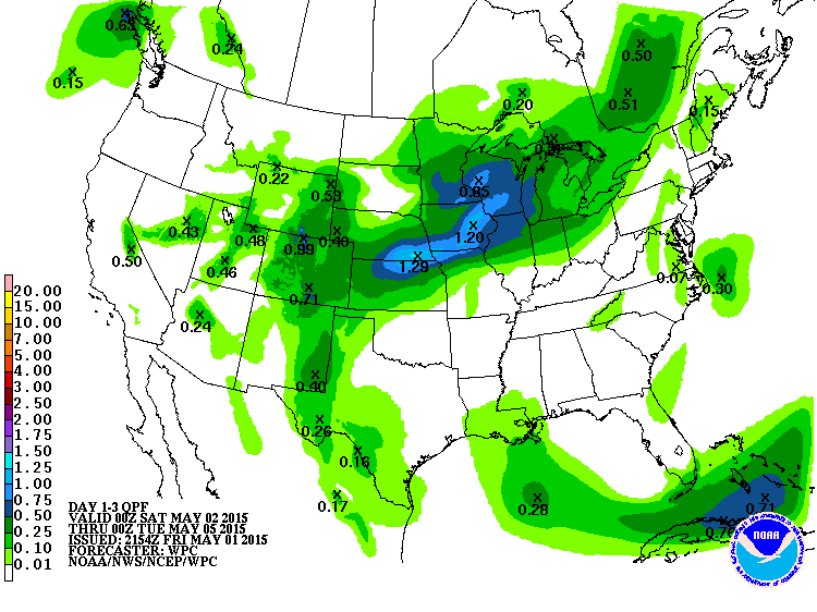
3 Day Precipitation Outlook
According to NOAA's HPC, the 3 day precipitation outlook shows a decent swath of heavier moisture across parts of the Midwest through PM Monday. Thanks to a few heavier showers and thunderstorms, up to 1" or more rainfall may be possible.
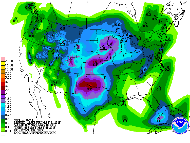
7 Day Precipitation Outlook
An extended precipitation outlook through late next week shows heavier moisture potential across the middle part of the country. While it's tough to nail down specifics this far in advance, it's nice to see some much needed precipitation potential return to parts of the area.
____________________________________________________________________
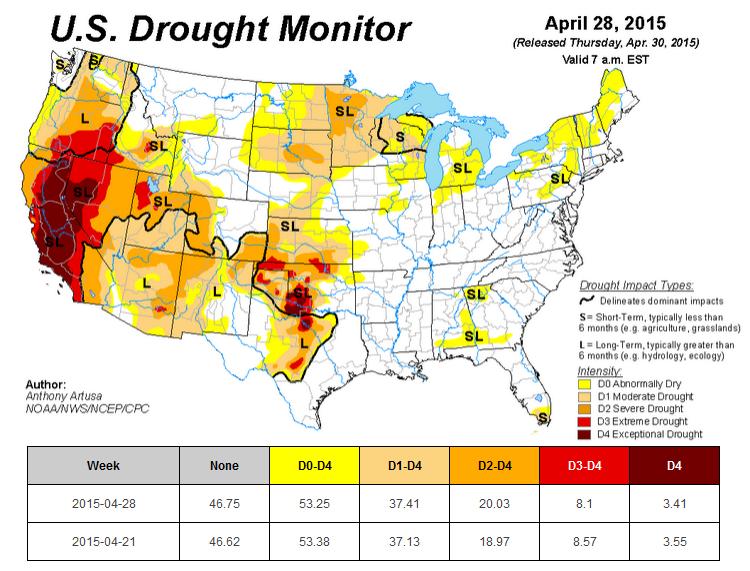
U.S. Drought Monitor
According to the U.S. Drought monitor, there is still about 3.5% EXCEPTIONAL DROUGHT across the country, it has improved some since last week, but not in California. Drought conditions in California remain the same and there are still nearly 37 million people in the state affected by drought.
Minnesota drought conditions worsened across the northwestern part of Minnesota to SEVERE DROUGHT. Last week, 92.32% of Minnesota was under a MODERATE DROUGHT and 0% was under a severe drought, now 92.45% of Minnesota is under moderate drought and 31.88% is under severe drought.
_________________________________________________________________________________
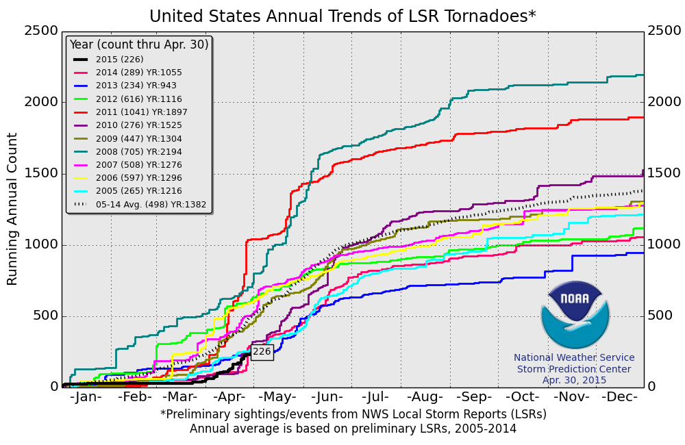
2015 PRELIMINARY Tornado Reports
According to NOAA's SPC, the preliminary 2015 tornado country (through April 30th) is only 226. Interestingly, the 2005-2014 average is nearly 500 through that date. This is the lowest number of preliminary tornado reports since 2005.
_______________________________________________________________________________
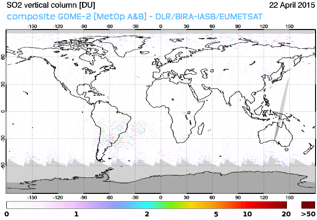
Volcanic Plume Crosses Atlantic
"European MetOp satellites have been monitoring aerosols blasted into the atmosphere by Chile's Calbuco volcano on April 22nd. A new 8-day movie shows a plume of sulfur dioxide (SO2) crossing the Atlantic from South America to Africa:"
See more from www.SpaceWeather.com HERE:
__________________________________________________________________
Thanks for checking in and have a great weekend ahead! Don't forget to follow me on Twitter @TNelsonWX

No comments:
Post a Comment