
Memories of June
By Todd Nelson
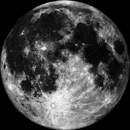
I am happy to report that spring fever has officially set in. Blooming flowers, green grass and yard chores; I could get used to this for a while. In fact, the full moon Sunday night is appropriately named the flower moon!
Keep in mind that two years ago today, we had a half an inch of snow. Today, we have a chance of afternoon showers and thunderstorms, some of which could be a little on the strong side across southeastern Minnesota. May is typically the fourth stormiest month out of the year, averaging 5 thunderstorm days. It appears that we could nearly fill our quota by the end of the week as a fairly unsettled weather pattern looks to set up. Some of the extended weather models are suggesting nearly 1 inch or more of rain by the end of the week, so it might be a good time to get a little weed and feed down on your lawn.
June-like temperatures will continue through much of the week with highs warming into the 70s to near 80 degrees. The average high for this time of the year is still in the mid 60s, so enjoy the warmth while it’s here!
Even though the traditional start to barbeque season is Memorial weekend, I think it is already underway after this weekend!
__________________________________________________________
SATURDAY NIGHT: Mostly clear, mild and quiet. Low: 59. Winds: SSW 5-10
SUNDAY: PM T-storms, strong to severe in southeastern MN? High: 81. Winds: S 5-15, turning NNW 10-20 late.
SUNDAY NIGHT: Partly cloudy and mild. Low: 51. Winds: NNW 5-15
MONDAY: Partly sunny. Not as warm, but still very mild. High: 70
TUESDAY: Clouding up, showers and storms arrive late, mainly in southern MN. Wake-up: 50. High: 65
WEDNESDAY: Mild. Spotty showers and storms. Wake-up: 55. High: 78
THURSDAY: Breezy. Heavy afternoon downpours. Wake-up: 62. High: 75
FRIDAY: Spotty afternoon shower or storm possible. Wake-up: 58. High: 75.
SATURDAY: Still unsettled. Spits of PM rain. Wake-up: 58. High: 75.
_________________________________________________________
This Day in Weather History
May 3rd
1905: "Mixed bag of weather." Western Minnesota was pelted with hail, while snow fell over the Arrowhead.
________________________________________________________
Average High/Low for Minneapolis
May 3rd
Average High: 66F (Record: 93F set in 1949)
Average Low: 45F (Record: 18F set in 1967)
_________________________________________________________
Sunrise/Sunset Times for Minneapolis
May 3rd
Sunrise: 6:00am
Sunset: 8:20pm
_________________________________________________________
Moon Phase for May 3rd
Full Flower Moon 10:42pm
_________________________________________________________
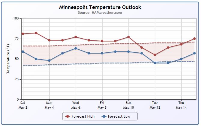
Minneapolis Temperature Trend
June-like temperatures continue through the week ahead with temperatures warming into the 70s to near 80 degrees. In fact, it doesn't look like there will be any substantial cool downs any time soon until maybe mid month.
____________________________________________________________
Sunday Weather Outlook
It'll be another mild day out ahead of a front pushing through the region. In fact, temperatures will once again warm into the 80s across the far southern part of Minnesota. Winds post front will begin switching out of the northwest and increase in intensity.
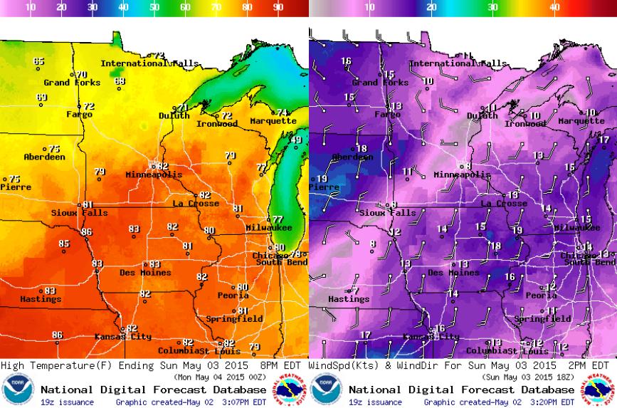
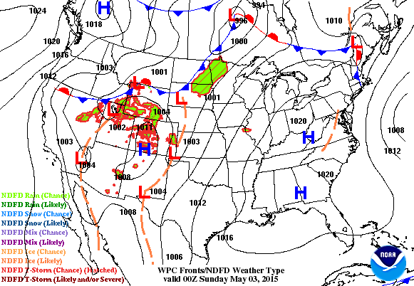
Sunday Weather Outlook
A cool front will sweep through the area on Sunday and kick out a few showers and storms through the afternoon and evening. The best potential for stronger PM storms will be across the southeastern part of the state and into parts of Wisconsin.
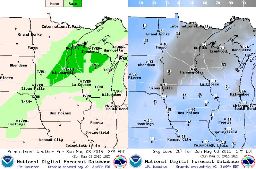
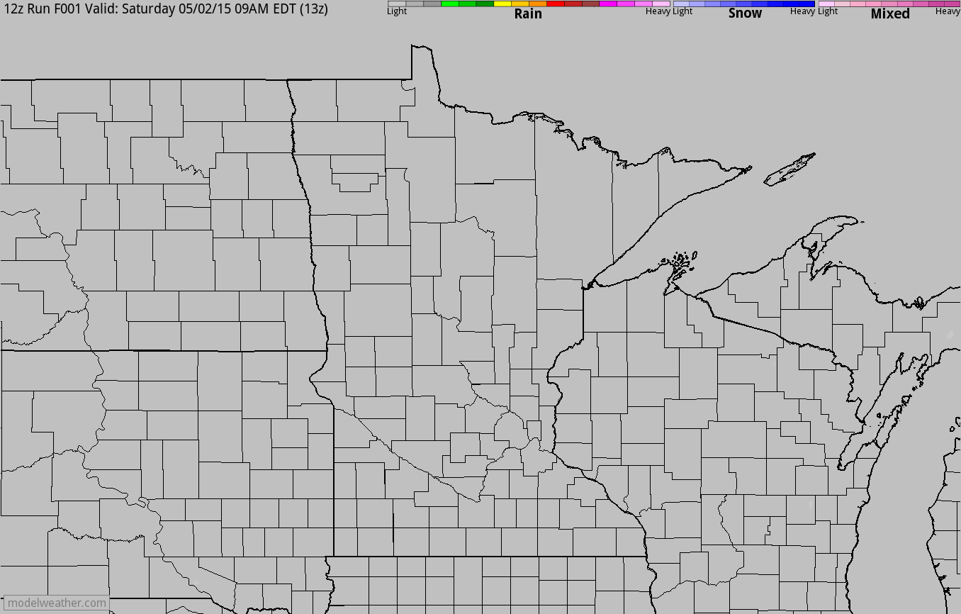
Simulated Radar
The simulated radar from AM Saturday through PM Monday shows a line of spotty showers and storms sliding through parts of northwest Minnesota late Saturday, then diminishing before redeveloping later Sunday across parts of Wisconsin and southeast Minnesota. Some of the storms later Sunday could be a little on the strong side.
National Weather Outlook
The front that will kick out showers and storms across parts of the Upper Midwest PM Sunday will eventually stall across the middle part of the country and keep ongoing rain chances going there. It appears that parts of the Central U.S. may be in for a fairly soggy next several days.
________________________________________________________________
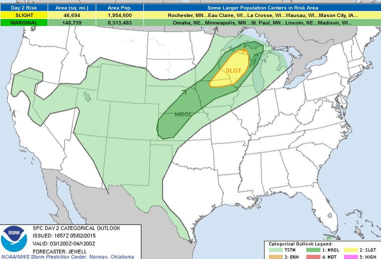
Severe Threat Sunday
...SUMMARY...
A FEW SEVERE STORMS WITH HAIL AND WIND ARE EXPECTED BY AFTERNOON
FROM WISCONSIN INTO NORTHEASTERN IOWA. A MORE ISOLATED AND MARGINAL
THREAT WILL EXIST FROM EASTERN NEBRASKA INTO WESTERN KANSAS.
...SYNOPSIS...
A BROAD UPPER TROUGH WILL SKIRT THE U.S./CANADIAN BORDER FROM THE
NRN PLAINS TOWARD THE GREAT LAKES WITH INCREASING WIND PROFILES FROM
MN INTO MI. A SURFACE TROUGH WILL EXTEND FROM LAKE SUPERIOR SWWD
ACROSS WI...NEB...AND INTO WRN KS BY AFTERNOON WITH DEWPOINTS
INCREASING INTO THE MID 50S F DUE TO SLY FLOW ACROSS THE PLAINS. THE
BEST COMBINATION OF INSTABILITY...SHEAR AND LIFT WILL EXIST ACROSS
THE UPPER MS VALLEY WITH A FEW SEVERE STORMS LIKELY.
OTHER ISOLATED STRONG STORMS ARE POSSIBLE FARTHER S ALONG THE TROUGH
ACROSS NEB...KS...AND THE TX PANHANDLE.
...WI..UPPER MI...SERN MN AND NERN IA...
LIFT ALONG THE FRONT AND A GRADUALLY DEEPENING OF THE MOIST BOUNDARY
LAYER WILL LEAD TO A BREAKING OF THE CAPPING INVERSION BY LATE
AFTERNOON WITH SCATTERED STORMS LIKELY. DEWPOINTS INTO THE 50S F
WILL BE MORE THAN SUFFICIENT TO SUPPORT STRONG UPDRAFTS GIVEN COLD
TEMPERATURES ALOFT. DEEP-LAYER SHEAR LOOKS TO BE FAVORABLE FOR
ORGANIZED SEVERE STORMS ACROSS THE REGION...BUT THE LINEAR FORCING
MECHANISM WILL LIKELY LEAD TO MIXED STORM MODES. LARGE HAIL AND
LOCALLY DAMAGING WIND GUSTS WILL BE POSSIBLE.
...ERN NEB INTO WRN KS...
STRONG HEATING AND STEEPENING LAPSE RATES WILL LEAD TO ZERO
INHIBITION BY AFTERNOON WITH THUNDERSTORMS LIKELY TO DEVELOP WITHIN
THE SFC TROUGH. SHEAR WILL BE WEAK BUT DEWPOINTS NEAR 50 F ALONG
WITH COLD PROFILES ALOFT WILL CREATE SUFFICIENT INSTABILITY FOR
PULSING UPDRAFTS CAPABLE OF MARGINALLY SEVERE HAIL AND/OR WIND. IN
ADDITION...A SLY LOW-LEVEL JET MAY AID IN STORM CLUSTER LONGEVITY
INTO THE EVENING FOR THE FEW THAT REMAIN.
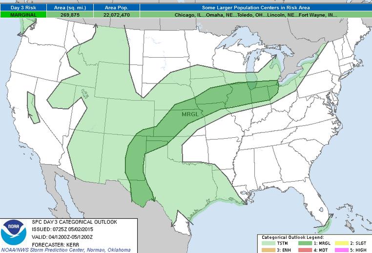
Severe Threat Monday
...SUMMARY...
ISOLATED TO WIDELY SCATTERED STRONG STORMS ARE EXPECTED MONDAY
WITHIN A CORRIDOR FROM THE SOUTHERN HIGH PLAINS...THROUGH THE
CENTRAL PLAINS...INTO PARTS OF THE MIDDLE MISSISSIPPI VALLEY AND
SOUTHERN PORTIONS OF THE GREAT LAKES REGION. SOME OF THESE COULD
BECOME CAPABLE OF PRODUCING MARGINALLY SEVERE HAIL AND LOCALIZED
STRONG WIND GUSTS.
...SYNOPSIS...
WITHIN THE STRONGEST BRANCH OF WESTERLIES EMANATING FROM THE
MID-LATITUDE PACIFIC...A LEAD SHORT WAVE IMPULSE APPEARS LIKELY TO
PROGRESS RAPIDLY EASTWARD THROUGH THE REMAINDER OF THE EASTERN
CANADIAN PROVINCES DURING THIS PERIOD...AS THE CENTER OF A BROADER
SCALE VORTEX REDEVELOPS EAST OF HUDSON BAY. UPSTREAM...A COUPLE OF
SIGNIFICANT PERTURBATIONS ARE FORECAST TO REMAIN PROGRESSIVE ACROSS
THE NORTHERN PACIFIC...INCLUDING ONE LIKELY TO REACH THE PACIFIC
NORTHWEST COAST BY MONDAY NIGHT...BUT THE LARGER-SCALE PATTERN MAY
BEGIN TO UNDERGO AMPLIFICATION. IN RESPONSE TO THESE LATTER
DEVELOPMENTS...MODELS INDICATE THAT A MID-LEVEL CLOSED
LOW/TROUGH...WITHIN A WEAKER SOUTHERN BRANCH OF MID-LATITUDE
WESTERLIES...WILL CONTINUE INLAND ACROSS THE SOUTHWESTERN U.S. AND
ADJACENT NORTHERN MEXICO...IN PHASE WITH THE SUBTROPICAL
STREAM...LIKELY APPROACHING THE SOUTHERN ROCKIES BY 12Z TUESDAY.
DOWNSTREAM...FURTHER AMPLIFICATION OF HIGH-LEVEL TROUGHING MAY OCCUR
ACROSS THE CARIBBEAN AND ADJACENT SOUTHEASTERN GULF OF MEXICO.
IN LOWER LEVELS...THE COLD FRONT ASSOCIATED WITH THE EASTERN
CANADIAN IMPULSE IS FORECAST TO ADVANCE EAST OF THE LOWER GREAT
LAKES...THROUGH MUCH OF THE NORTHEAST...WHILE STALLING...OR PERHAPS
BEGINNING TO SHIFT NORTHWARD...ACROSS PARTS OF THE SOUTHERN GREAT
LAKES...MIDDLE MISSISSIPPI VALLEY AND CENTRAL PLAINS. AS SURFACE
RIDGING REMAINS PROMINENT ACROSS MUCH OF THE NORTHERN GULF OF MEXICO
AND GULF COAST REGION...A RETURN FLOW OF RICH MOISTURE FROM THE GULF
OF MEXICO WILL CONTINUE TO BE INHIBITED. HOWEVER...SEASONABLY
MODEST MOISTENING /CHARACTERIZED BY SURFACE DEW POINTS AROUND 60F/
PROBABLY WILL PROCEED ON SOUTHEASTERLY UPSLOPE FLOW INTO THE
SOUTHERN HIGH PLAINS...AS WELL AS WITHIN A CORRIDOR ALONG THE
FRONTAL ZONE.
...SRN PLAINS INTO CNTRL PLAINS/MID MS VALLEY/SRN GREAT LAKES...
A NARROW CORRIDOR OF STRONGER DAYTIME HEATING AND DESTABILIZATION IS
EXPECTED TO BECOME FOCUSED BY LATE MONDAY AFTERNOON JUST SOUTH OF
THE SURFACE FRONT...AND TO THE IMMEDIATE LEE OF THE HIGHER TERRAIN
OF EASTERN NEW MEXICO AND SOUTHWEST TEXAS. THIS SEEMS LIKELY TO
OCCUR BENEATH LINGERING STEEP MID-LEVEL LAPSE RATES ASSOCIATED WITH
RESIDUAL ELEVATED MIXED LAYER AIR...WHICH PROBABLY WILL CONTRIBUTE
TO CONDITIONS CONDUCIVE TO VIGOROUS CONVECTIVE DEVELOPMENT.
ALTHOUGH DEEP LAYER FLOW AND SHEAR MAY REMAIN GENERALLY WEAK ACROSS
MOST AREAS...ISOLATED TO WIDELY SCATTERED STORMS CAPABLE OF
PRODUCING AT LEAST MARGINALLY SEVERE HAIL AND LOCALLY STRONG WIND
GUSTS APPEARS POSSIBLE...MAINLY DURING THE AFTERNOON AND EVENING.
____________________________________________________
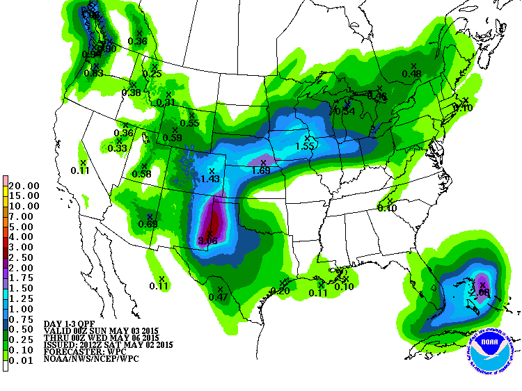
3 Day Precipitation Outlook
According to NOAA's HPC, the 5 day precipitation forecast suggests pockets of heavy rainfall across parts of the Central U.S.. The heaviest of which looks to be across the Panhandle of Texas and Oklahoma and far eastern New Mexico. Note that there also appears to be a fairly decent swath across parts of the Midwest as the front slowly slides south and stalls.
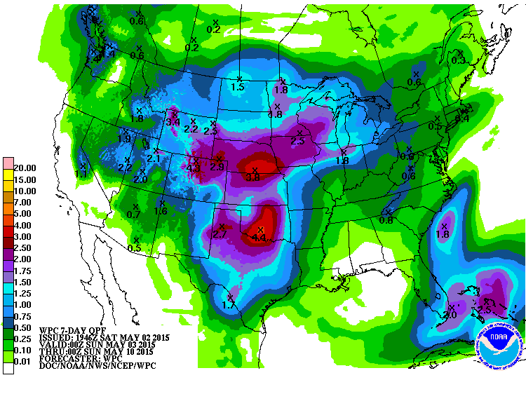
7 Day Precipitation Outlook
The 7 day precipitation outlook shows even heavy pockets of heavier rainfall potential across the Central U.S. According to NOAA's HPC, up to 2" to 4" of rain may be possible through PM Saturday.
___________________________________________________________
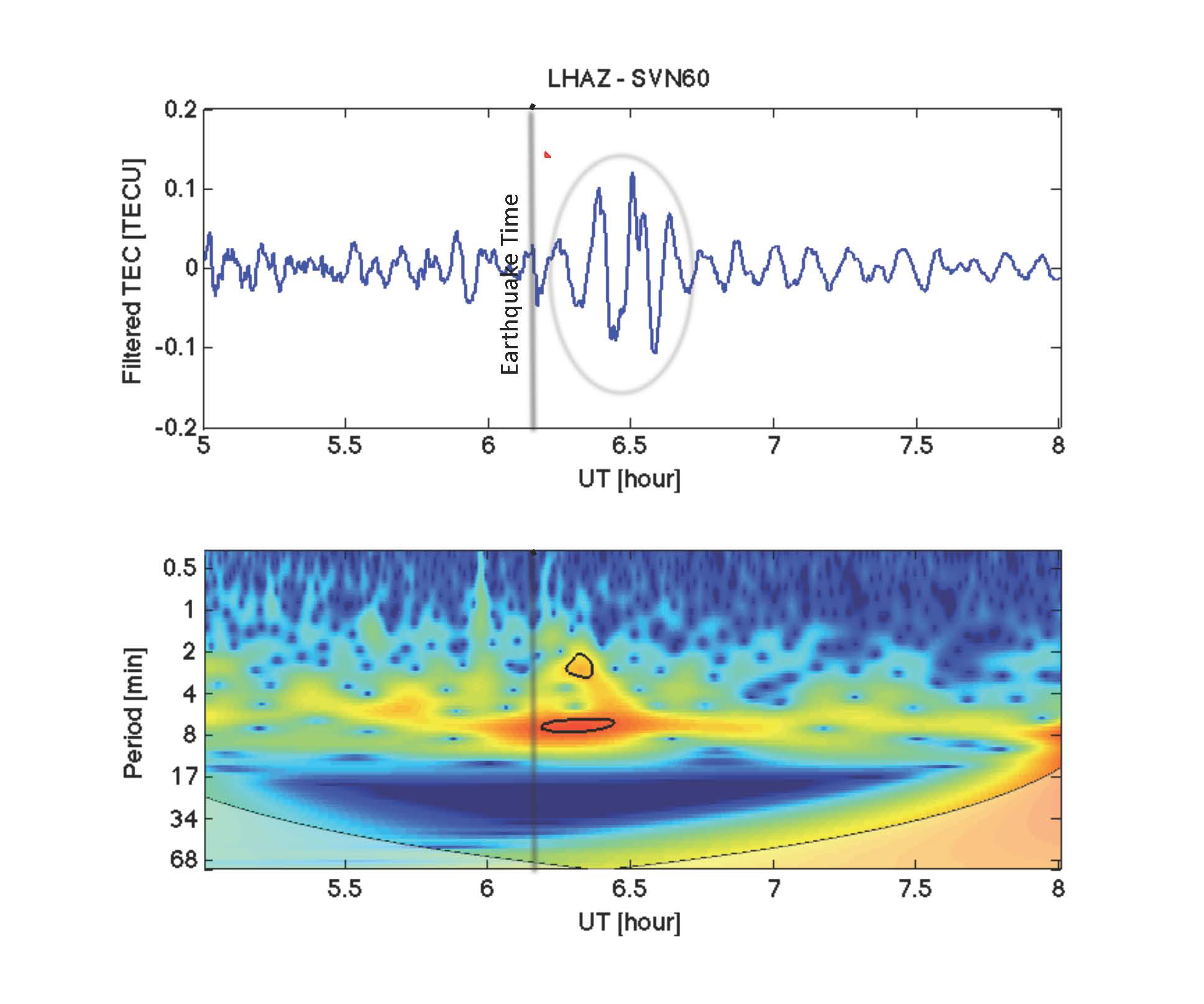
The Nepal Earthquake and Space Weather
"High above Earth, more than 60 km above sea level, there is a layer of our planet's atmosphere called "the ionosphere." It is where UV radiation from the sun strips electrons away from the atoms of normal air, creating a zone of charged gas that envelopes the globe.
The ionosphere is very sensitive to solar storms. Turns out, it can be sensitive to earthquakes, too. NASA is reporting that the magnitude 7.8 earthquake in Nepal on April 25th created waves of energy that penetrated the ionosphere and disturbed the distribution of electrons. Note the wave pattern, circled, in the upper panel of this ionospheric electron density plot:"
Read more from SpaceWeather.com HERE:
AND from NASA.gov HERE:
Thanks for checking in and have a great rest of your weekend. Don't forget to follow me on Twitter @TNelsonWX

No comments:
Post a Comment