Height of Summer
By Todd Nelson
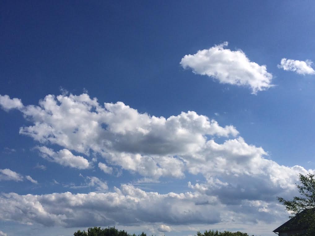
There's something about a summer sky that I just can't get enough of. Puffy, bloated cumulus clouds floating by with hints of blue would be a perfect meteorological canvas any day of the year for me. This is by far my favorite part of summer. I feel as if we decend down a summer slide after the 4th of July. Daylight hours become noticeably less and mid summer night dreams become a little more hot and humid. This will be a classic week of summer weather in Minnesota, soak it in!
A fairly vigorous area of low pressure will scoot through the region today with morning rumbles and possibly some late day severe storms across parts of Wisconsin. A breezy northwest wind this afternoon will help to usher in drier, sunnier weather through Tuesday. Our weather pattern remains somewhat unsettled this week with spotty thundershowers bubbling up during the PM hours a few times this week. Though no day looks like a washout, a few pockets of heavy rainfall can't be ruled out. With that said, your lawns and gardens will likely be a little more needy as the summer sun and warmth continues.
I am happy to report that no major heat waves are in sight just yet. Happy Summer!
___________________________________
SUNDAY NIGHT: Clouds increase, showers and storms possible by early morning. Low: 67
MONDAY: Few showers and T-showers early, turning breezy with some strong/severe PM storms developing across Wisconsin. High: 82. Winds: Turning NW 15-25.
MONDAY NIGHT: Mostly clear, not as breezy. Low: 61. Winds: NW 5-15.
TUESDAY: Plenty of sunshine, pleasant with a slight dip in humidity. High: 81
WEDNESDAY: Less sun, stray T-storms pop up. Wake-up: 64. High: 82
THURSDAY: Sunny, just about perfect. Wake-up: 65. High: 80
FRIDAY: Spotty PM T-showers. Wake-up: 63. High: 81
SATURDAY: More sun, late-day T-shower risk. Wake-up: 63. High: 82
SUNDAY: PM rumbles, not a washout. Wake-up: 62. High: 82.
____________________________________
This Day in Weather History
June 22nd
1988: The sky was smoky across much of Minnesota due to wild fires during the '88 drought.
1919: 2nd most deadly tornado in Minnesota history hits Fergus Falls. 59 people died. Like the #1 killer tornado for Minnesota (St. Cloud), it struck on a weekend.
1917: Downpour at Grand Meadow. 4.98 inches fell in just less than a day. Corn crops were badly damaged by the water.
This "Day in Weather History" contains come memorable weather events and trivia from 1805 to the present day for much of Minnesota and west central Wisconsin. Many sources were used to research and compile the data. The Twin Cities/Chanhassen National Weather Service would especially like to thank the Minnesota State Climatology Office and its contributors for their input into this database.
_____________________________________
Average High/Low for Minneapolis
June 22nd
Average High: 81
Average Low: 61
_____________________________________
Sunrise/Sunset Times for Minneapolis
June 22nd
Sunrise: 5:27am
Sunset: 9:03pm
____________________________________
Moon Phase for June 22nd at Midnight
2.2 Day Before First Quarter
______________________________________
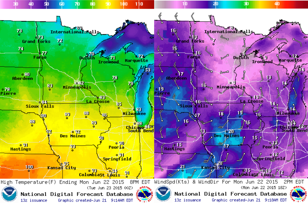
Weather Outlook for Monday, June 22nd
Monday is the first FULL day of summer and temperatures will be pretty close to average for mid/late June. Highs across southern MN will be in the lower 80s, while temperatures temperatures in the northern part of the state will be in the 70s. Note that the summer heat isn't far away with highs in the 90s/100s across parts of the central U.S.. Winds will also be picking up late in the day across the Dakotas and far western MN.
Weather Outlook for Monday June, 22nd
Strong thunderstorms with gusty winds and heavy rainfall will be possible early in the day with lingering shower and thunderstorm activity will linger through the first part of the day. The second half of the day will feature some clearing, but any additional thunderstorm activity that develops through the afternoon/evening (mainly in Wisconsin) could be strong to severe.

_________________________________
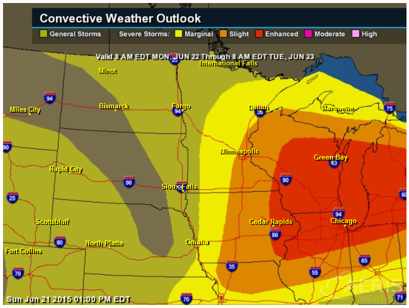
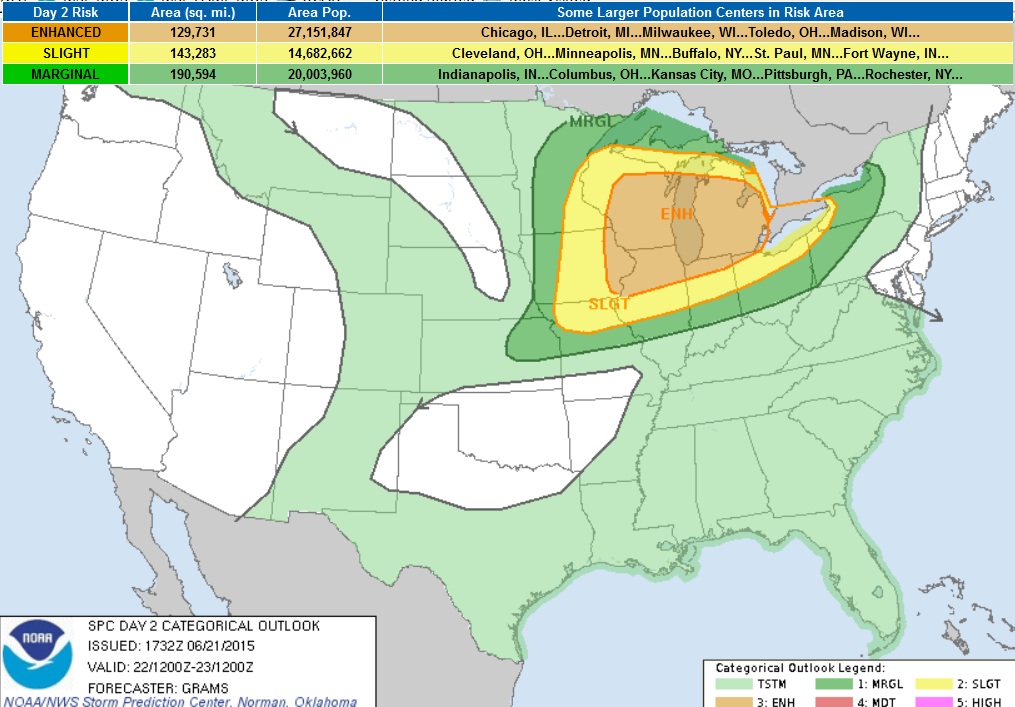
Severe Threat Monday
The Storm Prediction Center has issued a SLIGHT RISK of severe weather across parts of MN and an ENHANCED RISK for parts of WI Monday. Afternoon/evening thunderstorm activity could initially feature large hail and tornadoes with more of a damaging wind and heavy rain threat taking over late in the day as the storm system slides into the Great Lakes Region overnight.
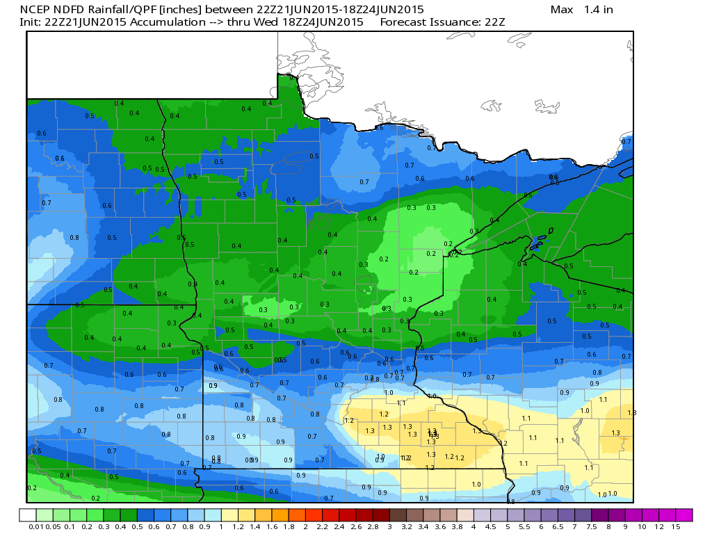
Rainfall Potential Through PM Tuesday
Thunderstorm moving through the region will produce heavy rainfall across parts of the state. At this point, the best chance for nearly 1" or more will be across the southern part of the state into central and southern WI.
__________________________________________
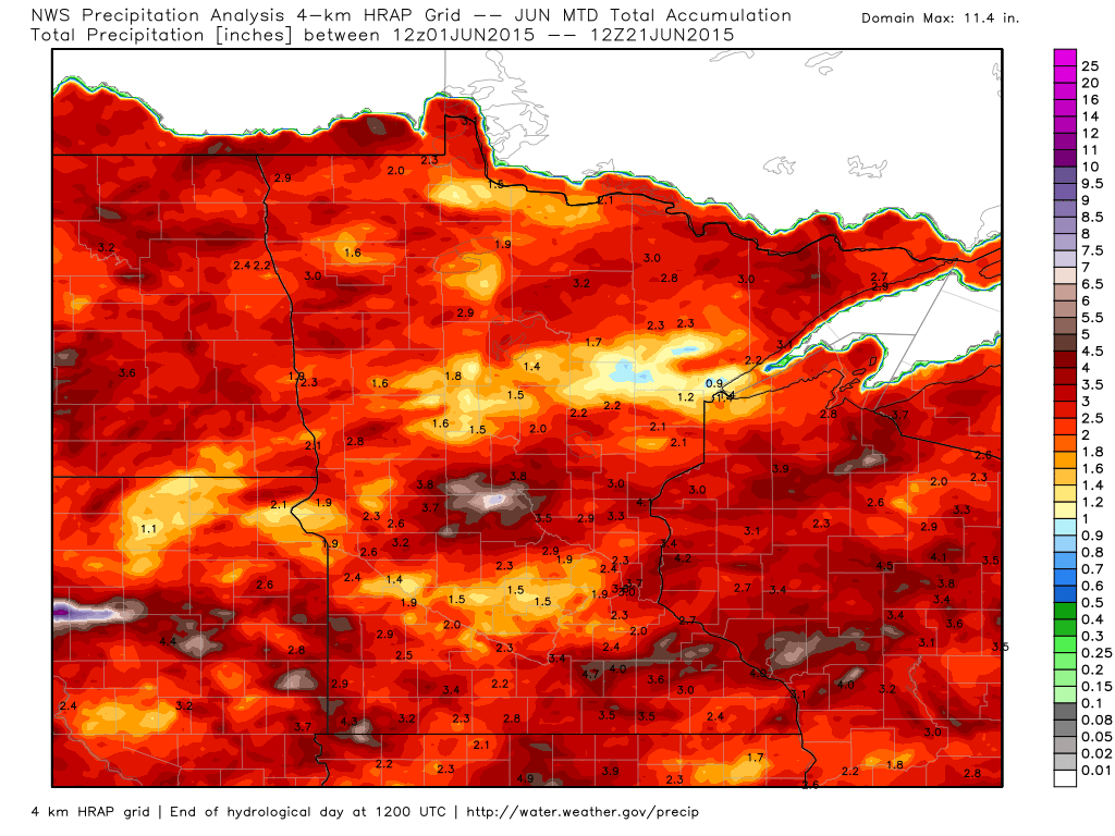
June Rainfall
Here's a look at our rainfall so far this month across the state. Note that there have been some pockets of heavy rainfall across central and southern MN, but a majority of the state has seen 1" to nearly 3".
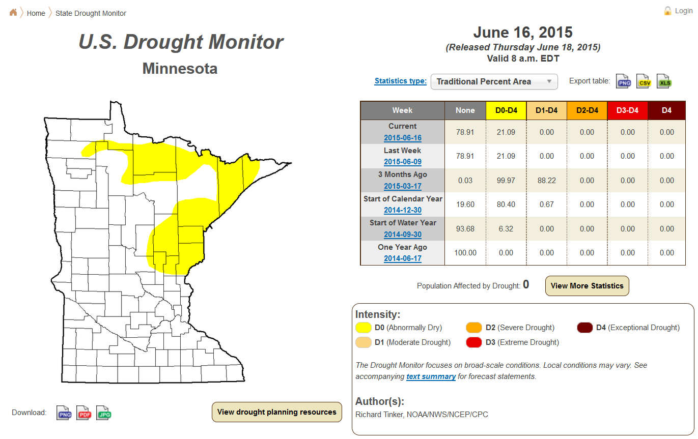
Minnesota Drought Update
Thanks to some of the recent rainfall over the last several weeks, we've had a pretty decent drop in the drought that was earlier this spring. According to the U.S. Drought Monitor, only 21% of the state is considered to be abnormally dry compared to 3 months ago when nearly 88% of the state was in a moderate drought.
_________________________________________
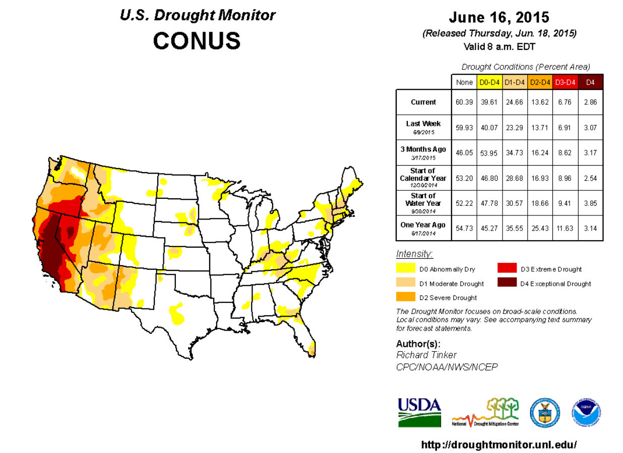
National Drought Update
The heavy rainfall across the south central part of the U.S. over the last several weeks has completely obliterated the drought that was so widespread earlier in 2015 and through 2014. Unfortunately, rainfall across parts of Texas and Oklahoma was so intense that flooding was a major issue. Meanwhile, drought conditions in the western U.S. continue and is still a major issue there, especially in California where nearly 47% of the state is considered to be in an exceptional drought.
National Precipitation Outlook
According to NOAA's HPC, the 5 day precipitation suggests that much of the western U.S. stays dry through next weekend! Meanwhile, shower and thunderstorm activity across the Midwest, Ohio Valley, Great Lakes and Northeast will produce pockets of heavy rainfall of 1" to nearly 3" or more through next weekend. Spotty shower and thunderstorm activity across the southern tier of the nation will produce pockets of heavy rainfall, but it shouldn't be very widespread.
National Weather Outlook
Here's the national weather outlook through Tuesday. Note the impulse of energy that slides across the northern tier of the nation from Sunday to Tuesday. This will be responsible for areas of strong to severe thunderstorms with damaging winds and heavy rainfall the primary concerns.
Severe Threat Monday
...SUMMARY... SCATTERED SEVERE STORMS ARE LIKELY ACROSS PARTS OF THE UPPER MISSISSIPPI VALLEY AND GREAT LAKES REGIONS...SOME OF WHICH SHOULD BE INTENSE...MAINLY FROM MIDDAY THROUGH THE EVENING ON MONDAY.
...UPPER MS VALLEY/GREAT LAKES... STRONGLY CONSIDERED AN UPGRADE TO MODERATE RISK WITH POTENTIAL FOR CLUSTERS OF INTENSE SEVERE STORMS WITH ALL SIGNIFICANT SEVERE HAZARDS POSSIBLE. BUT WILL DEFER GIVEN ENOUGH UNCERTAINTY WITH REGARD TO EVOLUTION OF LATE D1 CONVECTION WITH ITS SUBSEQUENT EFFECT ON THE DEGREE OF DOWNSTREAM DIURNAL DESTABILIZATION...ALONG WITH TIMING OF THE PAIR OF MID-LEVEL SHORTWAVE IMPULSES WITH RESPECT TO PEAK HEATING. GUIDANCE IS CONSISTENT IN DEPICTING STRENGTHENING LOW/MID-TROPOSPHERIC FLOW IN RESPONSE TO A CONVECTIVELY-GENERATED MCV FROM LATE D1/EARLY D2 AND APPROACH OF AN UPSTREAM SHORTWAVE TROUGH CURRENTLY OVER THE SRN CANADIAN ROCKIES. THESE FEATURES WOULD ENHANCE LOW-LEVEL WAA OF THE RICHLY BUOYANT AIR MASS CURRENTLY PRESENT OVER THE LOWER MO VALLEY. AVAILABLE CAMS VARY MARKEDLY WITH THE DAYTIME EVOLUTION OF AN MCS EXPECTED TO BE ONGOING ACROSS PARTS OF SRN MN/NRN IA. IT SEEMS PLAUSIBLE THAT THIS ACTIVITY SHOULD PERSIST THROUGH THE DAY WITH AN ORGANIZED SEVERE RISK ON THE EDGE OF A ROBUST PLAINS EML. THIS TYPE OF SCENARIO MAY RESULT IN LEAD CONVECTION OUTPACING THE MORE FAVORABLE THERMODYNAMIC ENVIRONMENT CHARACTERIZED BY RATHER STEEP MID-LEVEL LAPSE RATES AND VERY LARGE BUOYANCY. AT LEAST SCATTERED UPSTREAM TSTM DEVELOPMENT SHOULD OCCUR BY LATE AFTERNOON ALONG THE COLD FRONT FROM CNTRL/ERN WI SW TO THE IA/IL BORDER AREA AS CONVERGENCE ALONG THE FRONT AND DIABATIC HEATING OVERCOME INHIBITION DUE TO THE INITIALLY STOUT EML. SUPERCELLS ARE EXPECTED IN INITIAL STAGES OF DEVELOPMENT...WITH SOME OF THIS CONVECTION GROWING UPSCALE DURING THE EVENING. WITH LOW-LEVEL FLOW BECOMING INCREASINGLY VEERED IN THE WAKE OF THE LEAD MID-LEVEL IMPULSE...MAIN HAZARDS WITH SW EXTENT SHOULD BE VERY LARGE HAIL TRANSITIONING TO PREDOMINATELY SEVERE WIND. WHERE 850 MB WINDS CAN REMAIN QUITE STRONG WITH ENLARGED LOW-LEVEL HODOGRAPHS /MOST LIKELY IN ERN WI TO LOWER MI/...A RISK FOR STRONG TORNADOES AND/OR SIGNIFICANT SEVERE WIND GUSTS MAY DEVELOP.
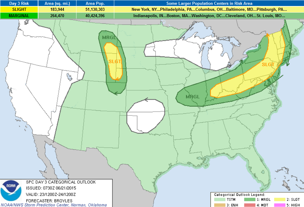
Severe Threat Tuesday
...SUMMARY... SEVERE THUNDERSTORMS WITH HAIL AND ISOLATED DAMAGING WIND GUSTS WILL BE POSSIBLE FROM THE OHIO VALLEY NORTHEASTWARD INTO THE CENTRAL AND NORTHERN APPALACHIAN MOUNTAINS ON TUESDAY. SEVERE THUNDERSTORMS WITH ISOLATED LARGE HAIL AND WIND DAMAGE WILL ALSO BE POSSIBLE IN THE CENTRAL AND NORTHERN HIGH PLAINS.
...OH VALLEY/CNTRL APPALACHIAN MTNS... AN UPPER-LEVEL TROUGH IS FORECAST TO MOVE INTO THE NERN STATES ON TUESDAY AS A COLD FRONT ADVANCES QUICKLY SEWD INTO THE CNTRL APPALACHIANS EXTENDING WWD INTO THE OH VALLEY. ALONG AND SOUTH OF THE BOUNDARY...SFC DEWPOINTS IN THE LOWER TO MID 70S F SHOULD RESULT IN A STRONGLY UNSTABLE AIRMASS BY AFTERNOON FROM PARTS OF THE MID-MS VALLEY EWD INTO THE UPPER OH VALLEY. ALTHOUGH LARGE-SCALE ASCENT IS FORECAST TO REMAIN WEAK ACROSS THIS CORRIDOR...THUNDERSTORMS COULD INITIATE ALONG THE BOUNDARY AS SFC TEMPS WARM DURING THE DAY AND LOW-LEVEL CONVERGENCE INCREASES ALONG THE BOUNDARY. IN ADDITION TO STRONG INSTABILITY...NAM FORECAST SOUNDINGS ACROSS THE OH VALLEY AT 21Z ON TUESDAY SHOW UNIDIRECTIONAL WIND PROFILES WITH 30 TO 40 KT OF FLOW FROM 700 TO 500 MB. THIS MAY CREATE AN ENVIRONMENT SUPPORTIVE OF DAMAGING WIND GUSTS WITH MULTICELL LINE-SEGMENTS THAT ORGANIZE DURING THE LATE AFTERNOON AND EARLY EVENING. DUE TO WEAK LARGE-SCALE ASCENT...CONVECTION IS EXPECTED TO REMAIN SOMEWHAT ISOLATED ACROSS THE REGION.
...NRN APPALACHIAN MTNS/MID-ATLANTIC/NEW ENGLAND... AN UPPER-LEVEL TROUGH IS FORECAST TO MOVE EWD INTO NERN STATES ON TUESDAY AS A COLD FRONT ADVANCES EWD FROM THE LOWER GREAT LAKES INTO THE NRN APPALACHIAN MTNS. THE EXIT REGION OF A 60 TO 80 KT MID-LEVEL JET IS FORECAST TO OVERSPREAD NY AND NEW ENGLAND DURING THE EARLY AFTERNOON. THIS WILL CREATE STRONG DEEP-LAYER SHEAR PROFILES THAT COULD BE FAVORABLE FOR SEVERE STORMS AS SFC TEMPS WARM UP DURING THE DAY. THE MODELS SUGGEST THAT CONVECTION MAY BE ONGOING ALONG THE FRONT AT THE START OF THE PERIOD WITH AN MCS MOVING QUICKLY EWD ACROSS THE REGION DURING THE LATE MORNING AND EARLY AFTERNOON. AHEAD OF THE FRONT...A MOIST AIRMASS SHOULD BE IN PLACE WITH MODERATE INSTABILITY DEVELOPING BY MIDDAY. THIS COMBINED WITH FOCUSED LARGE-SCALE ASCENT AND STRONG DEEP-LAYER SHEAR MAY ENABLE THUNDERSTORMS THAT DEVELOP ALONG THE FRONT TO HAVE A WIND DAMAGE THREAT DURING THE EARLY TO MID AFTERNOON.
...CNTRL AND NRN HIGH PLAINS... ZONAL FLOW IS FORECAST ACROSS THE NCNTRL STATES ON TUESDAY AS A LEE TROUGH DEVELOPS FROM ERN MT SWD INTO ERN WY AND NERN CO. UPSLOPE FLOW AND SFC DEWPOINTS IN THE 50S AND LOW 60S F SHOULD RESULT IN AN AXIS OF MODERATE INSTABILITY ALONG THE LEE TROUGH BY AFTERNOON. IN SPITE OF LIMITED LARGE-SCALE ASCENT...THUNDERSTORMS MAY INITIATE IN THE HIGHER TERRAIN AS SFC TEMPS WARM AND THEN MOVE EWD ACROSS THE CNTRL AND NRN HIGH PLAINS DURING THE LATE AFTERNOON AND EARLY EVENING. FORECAST SOUNDINGS IN ERN WY AT 00Z/FRIDAY SHOW MLCAPE NEAR 2000 J/KG WITH 45-50 KT OF 0-6 KM SHEAR. THIS SHOULD BE ENOUGH FOR AN ISOLATED SEVERE THREAT WITH SUPERCELL DEVELOPMENT POSSIBLE. SUPERCELLS MAY BE ACCOMPANIED WITH ISOLATED LARGE HAIL AND SEVERE WIND GUSTS.
_________________________________
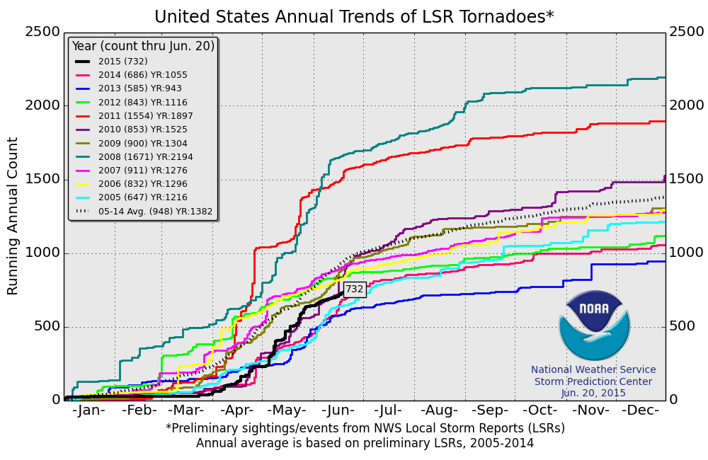
2015 Tornado Report
According to NOAA's SPC, the 2015 preliminary tornado report suggests that there have been 732 tornadoes through June 20th. This is nearly 200 below the 2005-2014 average of 948, however this is more than what we've seen through this date over the past couple of years.
2015 Tornado Report Map
The map below shows all the preliminary tornado reports so far this year across the nation. Texas and Oklahoma have seen nearly 150 preliminary tornado reports this year, while Minnesota has only seen 9 preliminary tornado reports. Interestingly, Minnesota averages nearly 25 tornado reports through the end of June and averages 45 annually.
Thanks for checking in and have a great week ahead! Don't forget to follow me on Twitter @TNelsonWX

No comments:
Post a Comment