Atmospheric Lag
By Todd Nelson
The
longest day of the year occurred 2 days ago on the Summer Solstice when
the sun's most direct rays were shining over the Tropic of Cancer.
Since then, we've actually lost 10 seconds of daylight! The good news is
that we still have nearly 15 and 1/2 hours of daylight in Minneapolis
through early July.
Even though we are losing daylight, our average temperature continues to rise through mid July thanks to the atmospheric or seasonal lag. Because our atmosphere is largely made up of water, it takes a while for it to warm up or cool down even after maximum or minimum times of solar insolation.
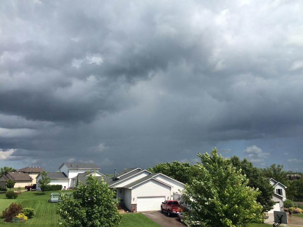
Temperatures today will be near average for late June with highs near 80 degrees. A light breeze and mostly sunny skies will make for a nearly perfect early summer day. Another impulse of energy arrives tomorrow with spotty showers and storms, mainly across southern Minnesota. Weather conditions stay a little on the unsettled side much of the rest of the week as isolated rumbles may be possible each afternoon through the weekend. Keep in mind that no day looks like a washout.
I still don't see any heat waves brewing. Until then, enjoy the summer breeze!
________________________
MONDAY NIGHT: Mostly clear, not as breezy. Low: 61. Winds: NW 5-15.
TUESDAY: Plenty of sunshine, pleasant with a slight dip in humidity. High: 81
TUESDAY: Plenty of sunshine, pleasant with a slight dip in humidity. High: 81
TUESDAY NIGHT: Partly cloudy, nothing rough. Low: 63.
WEDNESDAY: More clouds, thunder develops late. High: 81
THURSDAY: Spotty afternoon rumbles. Wake-up: 64. High: 78
FRIDAY: Isolated PM T-shower possible. Wake-up: 63. High: 80
SATURDAY: Dry start, late day rumble. Wake-up: 62. High: 81
WEDNESDAY: More clouds, thunder develops late. High: 81
THURSDAY: Spotty afternoon rumbles. Wake-up: 64. High: 78
FRIDAY: Isolated PM T-shower possible. Wake-up: 63. High: 80
SATURDAY: Dry start, late day rumble. Wake-up: 62. High: 81
SUNDAY: More humid, scattered PM storms. Wake-up: 63. High: 81.
MONDAY: Sun returns, still mild. Wake-up: 65. High: 82.
________________________
________________________
This Day in Weather History
June 23rd
June 23rd
2002:
Just a few weeks after torrential rains hit the area, another round of
heavy rain hit northern Minnesota. This time up to eight inches fell in a
two-day period in small parts of Mahnomen and St. Louis Counties.
1992: Chilly air across Minnesota with a high of 48 at the Duluth Harbor and 52 at Grand Marais.
_________________________
_________________________
Average High/Low for Minneapolis
June 23rd
June 23rd
Average High: 81 (Record: 99 set in 1937)
Average Low: 61 (Record: 44 set in 1972)
__________________________
Average Low: 61 (Record: 44 set in 1972)
__________________________
Sunrise/Sunset Times for Minneapolis
June 23rd
June 23rd
Sunrise: 5:27am
Sunset: 9:03pm
_________________________
Sunset: 9:03pm
_________________________
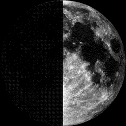
Moon Phase for June 23rd at Midnight
0.2 Days Before First Quarter
0.2 Days Before First Quarter
______________________________
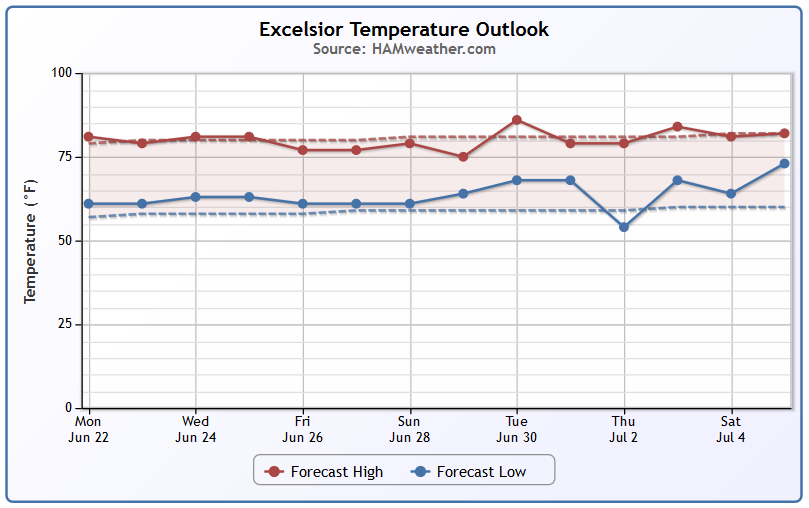
Minneapolis Temperature Trend
Temperatures
look to stay near average over the next several days (near 80F) with
lows staying close to near average as well (near 60F). At this point, I
don't see any major cool downs or heat waves in the near future.
_______________________________
Tuesday Weather Outlook
Tuesday
looks like a very comfortable day with highs near 80F, light winds and
plenty of blue sky. Tuesday will be an almost perfect early summer day!
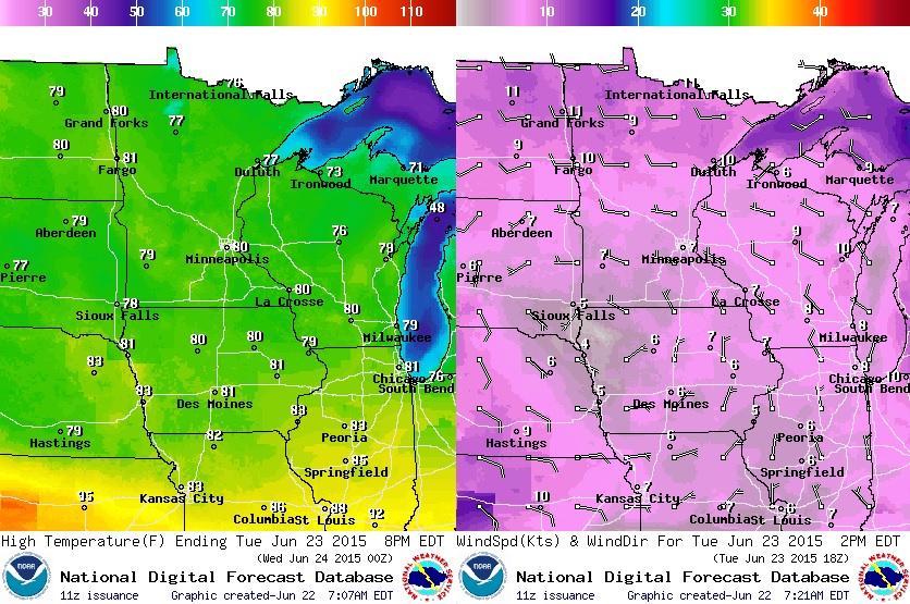
Tuesday Weather Outlook
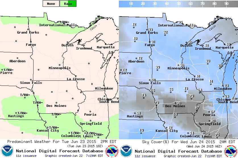
Much
of the region will be dry and sunny with the exception being along the
international border where a few spotty showers may be possible.
Minnesota Rainfall Potential
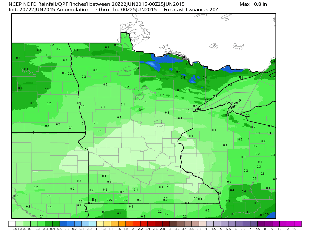
Rainfall
potential through doesn't look all that impressive across Minnesota.
Some of the heaviest looks to stay along the international border with
pockets of near 0.5" possible through 7pm Wednesday.
______________________________________
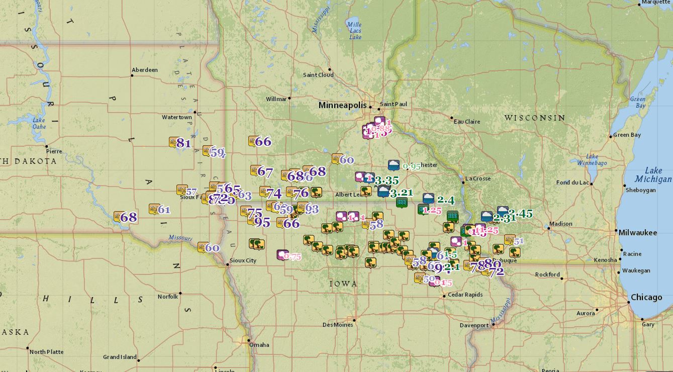
Monday Morning Recap:
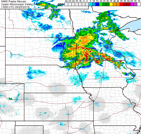
Tis
the season for overnight thunderstorm activity with damaging winds
being the primary threat. Sunday night/early Monday morning featured a
complex of thunderstorms that was responsible for several damaging wind
reports with wind speeds reaching 95mph in Sheldon, IA. Take a look at
what the radar looked like early Monday morning.
Thunderstorm
wind gusts were responsible for this overturned semi near Canton, SD
early this morning. Sioux Falls, SD had wind gusts topping 80mph!

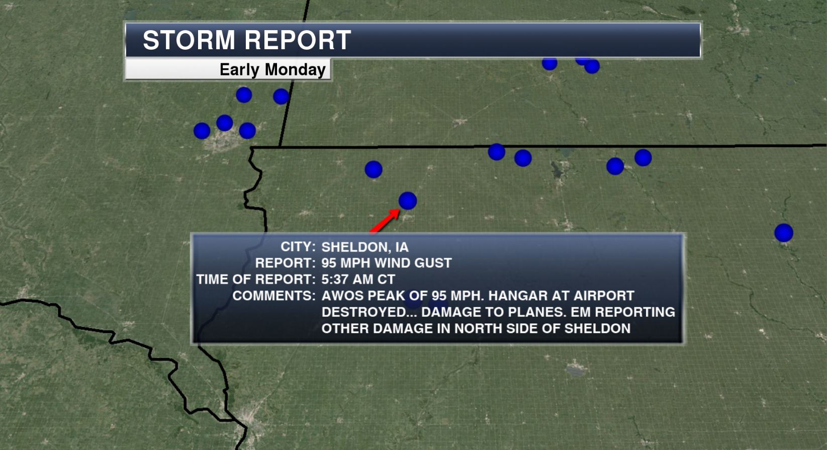
Here
is the 95mph wind report from Sheldon, IA located in the northwest part
of the state. Note the report states an airplane hangar was destroyed
with damage occurring to planes.
Hail,
high wind and damaging wind reports stretched from eastern South Dakota
through Minnesota, Iowa and eventually into Wisconsin and Illinois.
Note the 95mph wind gust report in northwest IA.
_____________________________________
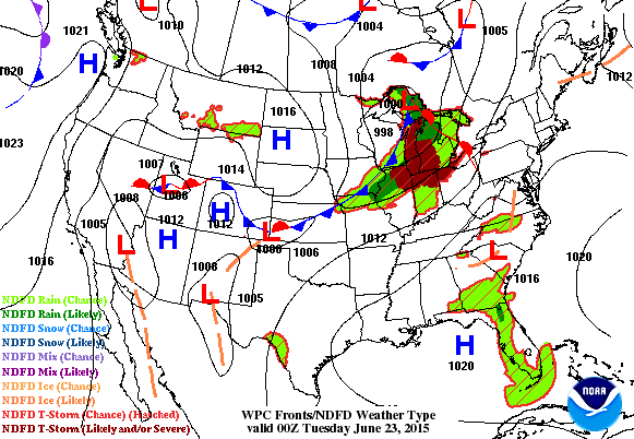
National Weather Outlook
The
storm system that pushed through the Upper Midwest earlier this week
will be responsible for scattered thunderstorms across parts of the
Northeast and Ohio Valley on Tuesday, some of which could be on the
strong to severe side. Meanwhile, an area of high pressure move in to
the Midwest on Tuesday making for a beautiful day. However, another
impulse of energy pushes into the region by midweek.
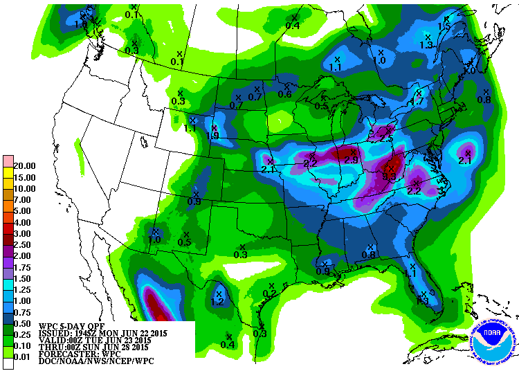
5 Day Precipitation Outlook
According
to NOAA's HPC, the heaviest rainfall over the next 5 days looks to fall
over parts of the Ohio and Tennessee Valley through the Mid-Atlantic
States. Meanwhile, areas in the Western U.S. look to stay mostly dry
through Saturday.
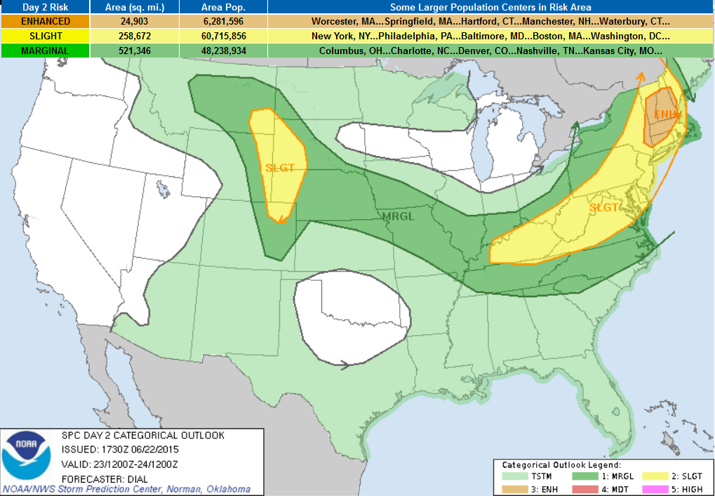
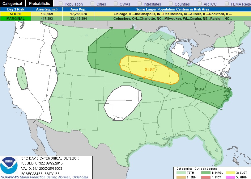
Severe Threat Tuesday
...SUMMARY...
SEVERE THUNDERSTORMS WITH LARGE HAIL AND DAMAGING WIND GUSTS ARE
EXPECTED FROM PORTIONS OF NEW ENGLAND INTO THE CENTRAL APPALACHIANS AND
OHIO VALLEY. FARTHER WEST...OTHER SEVERE STORMS WITH LARGE HAIL AND
ISOLATED WIND DAMAGE WILL ALSO BE POSSIBLE IN THE CENTRAL AND NORTHERN
HIGH PLAINS FROM LATE TUESDAY AFTERNOON THROUGH THE EVENING.
...NORTHEAST STATES... MCS WILL BE ONGOING EARLY TUESDAY MOST LIKELY
OVER PORTIONS OF NEW ENGLAND GENERALLY ALONG AND NORTH OF A WARM FRONT
THAT IS EXPECTED TO EXTEND FROM SRN NH AND VT NWWD INTO SRN QUEBEC. THE
ATMOSPHERE IS EXPECTED TO DESTABILIZE IN WAKE OF AND UPSTREAM OF THE MCS
AS RICHER LOW-LEVEL MOISTURE IS ADVECTED NEWD THROUGH WARM SECTOR IN
ADVANCE OF A SEWD ADVANCING COLD FRONT. SOME BREAKS IN RESIDUAL LOW
CLOUDS ARE EXPECTED WITH MLCAPE UP TO 1500 J/KG POSSIBLE IN THIS REGION.
STORMS ARE EXPECTED TO REDEVELOP ALONG AND JUST AHEAD OF THE COLD FRONT
FROM NEWD ENGLAND SWWD INTO THE NERN U.S. AND MID ATLANTIC. IMPRESSIVE
DEEP LAYER WINDS ASSOCIATED WITH A PROGRESSIVE SHORTWAVE TROUGH WILL
SPREAD ACROSS THE NRN PORTIONS OF THE WARM SECTOR WITH 40-50 KT 0-6 KM
SHEAR SUPPORTIVE OF ORGANIZED STORMS INCLUDING SUPERCELLS AND BOWING
SEGMENTS. WIND PROFILES WILL BECOME WLY UNIDIRECTIONAL SOUTH OF WARM
FRONT SUGGESTING PRIMARY THREAT WILL BE LARGE HAIL AND DAMAGING WIND.
HOWEVER...AN EXCEPTION WILL BE OVER NEW ENGLAND WHERE A THREAT FOR A FEW
TORNADOES WILL BE CONDITIONAL UPON SUFFICIENT DESTABILIZATION IN
VICINITY OF THE CONVECTIVELY ENHANCED WARM FRONT. ...MID ATLANTIC
THROUGH SRN OH VALLEY TN VALLEY AND NC... MUCH OF THIS REGION WILL
RESIDE ON SRN PERIPHERY OF STRONGER WINDS ALOFT WHERE VERTICAL SHEAR
WILL SUPPORT PRIMARILY MULTICELL MODES. STRONG DIABATIC WARMING AND
DESTABILIZATION OF THE BOUNDARY LAYER WILL LIKELY PROMOTE REDEVELOPMENT
OF STORMS ALONG THE CNTRL/SRN APPALACHIANS AND ALONG/AHEAD OF THE SEWD
ADVANCING COLD FRONT. ISOLATED DAMAGING WIND AND HAIL WILL BE THE MAIN
THREATS FROM AFTERNOON THROUGH EARLY EVENING. ...CNTRL AND NRN HIGH
PLAINS... MODIFIED CP AIR WITH DEWPOINTS IN THE 50S WILL RETURN NWD
THROUGH THE HIGH PLAINS BENEATH STEEP LAPSE RATES IN WAKE OF RETREATING
SFC RIDGE. THIS WILL CONTRIBUTE TO AN AXIS OF 500-1500 J/KG MLCAPE. MUCH
OF THIS REGION WILL RESIDE BENEATH ZONE OF FASTER WLY ALOFT RESULTING
IN 40-50 KT EFFECTIVE SHEAR. ISOLATED TO WIDELY SCATTERED STORMS ARE
EXPECTED TO DEVELOP OVER THE HIGHER TERRAIN AND SPREAD EWD INTO THE HIGH
PLAINS. SUPERCELLS WITH LARGE HAIL AND DAMAGING WIND APPEAR TO BE THE
MAIN THREATS. MORE NUMEROUS STORMS ARE EXPECTED OVERNIGHT OVER THE CNTRL
PLAINS WHERE A STRENGTHENING LLJ WILL AUGMENT ASCENT NORTH OF A STALLED
FRONT. POTENTIAL WILL EXIST FOR SOME OF THIS ACTIVITY TO GROW UPSCALE
POSING A RISK FOR LARGE HAIL AND DAMAGING WIND.
Severe Threat Wednesday
...SUMMARY...
A SEVERE THREAT IS EXPECTED TO DEVELOP FROM PARTS OF THE NORTHERN
PLAINS EAST SOUTHEASTWARD INTO THE UPPER MIDWEST ON WEDNESDAY. A TORNADO
THREAT ALONG WITH LARGE HAIL AND DAMAGING WIND GUSTS WILL BE POSSIBLE
DURING THE AFTERNOON AND EVENING WITH THE GREATEST POTENTIAL FOR SEVERE
STORMS LOCATED OVER PARTS OF THE UPPER MIDWEST. ...MID-MO VALLEY/UPPER
MIDWEST... AN UPPER-LEVEL TROUGH IS FORECAST TO MOVE INTO THE NRN PLAINS
ON WEDNESDAY. AT THE SFC...A LOW IS FORECAST TO MOVE INTO THE MID MO
VALLEY WITH A WARM FRONT LOCATED FROM NRN IA SEWD INTO NRN IL. A VERY
MOIST AIRMASS SHOULD BE IN PLACE FROM THE SFC LOW SEWD ACROSS THE MID MS
VALLEY WITH SFC DEWPOINTS IN THE LOWER 70S F. AS SFC TEMPS WARM ALONG
THIS CORRIDOR...MODERATE TO STRONG INSTABILITY SHOULD BE IN PLACE BY
MIDDAY. ALTHOUGH CELL INITIATION SEEMS POSSIBLE NEAR THE SFC LOW DURING
THE EARLY AFTERNOON...WARM TEMPERATURES AT MID-LEVELS MAY INHIBIT DEEP
CONVECTION FROM DEVELOPING UNTIL LATE AFTERNOON OR EARLY EVENING.
CONVECTIVE COVERAGE WILL PROBABLY BE GREATEST ALONG THE WARM FRONT WITH
THE ACTIVITY MOVING TO THE COOL SIDE OF THE BOUNDARY. DISCRETE CELL
FORMATION WILL ALSO BE POSSIBLE AS THE CAP BECOMES WEAKER DURING THE
LATE AFTERNOON TO THE SOUTH OF THE SFC LOW ACROSS PARTS OF IA WHERE
INSTABILITY AND LOW-LEVEL CONVERGENCE IS FORECAST TO BE MAXIMIZED. NAM
FORECAST SOUNDINGS FOR DES MOINES IA SEWD TO NEAR SPRINGFIELD IL AT
00Z/THURSDAY SHOW IMPRESSIVE THERMODYNAMIC PROFILES WITH MLCAPE IN THE
3000 TO 4000 J/KG RANGE AND 0-6 KM SHEAR OF 35 TO 40 KT. THIS SHOULD
SUPPORT SUPERCELLS AND LARGE HAIL WITH CELLS THAT REMAIN DISCRETE AND
HAVE ACCESS TO THE STRONGEST INSTABILITY. A TORNADO THREAT WILL BE
POSSIBLE WITH SUPERCELLS THAT INTERACT WITH THE WARM FRONT. A WIND
DAMAGE THREAT MAY ALSO DEVELOP WITH SUPERCELLS AND/OR BOWING LINE
SEGMENTS. ...NRN PLAINS... AN UPPER-LEVEL TROUGH IS FORECAST TO MOVE EWD
INTO THE NRN PLAINS ON WEDNESDAY AS A COLD FRONT ADVANCES SEWD ACROSS
ERN SD AND NRN NEB. THE POST-FRONTAL AIRMASS SHOULD BE MOIST WITH SFC
DEWPOINTS REMAINING IN THE 60S F. THIS SHOULD RESULT IN MODERATE
INSTABILITY ACROSS THE PARTS OF THE NRN PLAINS BY AFTERNOON. ISOLATED
CELL INITIATION WILL BE POSSIBLE DURING THE LATE AFTERNOON IN THE
POST-FRONTAL AIRMASS AS THE SHORTWAVE TROUGH MOVES ACROSS THE REGION.
FORECAST SOUNDINGS AT 21Z IN CNTRL SD SHOW SBCAPE AROUND 1500 J/KG WITH
50 KT OF 0-6 KM SHEAR BUT HAVE POOR LAPSE RATES. THIS ENVIRONMENT COULD
BE ENOUGH FOR MARGINALLY SEVERE STORMS WITH POTENTIAL FOR HAIL AND
STRONG WIND GUSTS. ...CNTRL APPALCHIANS/NORTH CAROLINA... A
QUASI-STATIONARY FRONT IS FORECAST TO BE IN PLACE FROM THE OH VALLEY
SEWD INTO THE CAROLINAS ON WEDNESDAY WITH SFC DEWPOINTS NEAR AND TO THE
SOUTH OF THE BOUNDARY IN THE UPPER 60S AND LOWER 70S F. THIS SHOULD
RESULT IN THE DEVELOPMENT OF MODERATE TO STRONG INSTABILITY WITH THE
INITIATION OF ISOLATED THUNDERSTORMS POSSIBLE ALONG THE FRONT DURING THE
AFTERNOON. ALTHOUGH LARGE-SCALE ASCENT IS FORECAST TO BE WEAK...THE
MAGNITUDE OF INSTABILITY COMBINED WITH ADEQUATE DEEP-LAYER SHEAR MAY BE
ENOUGH FOR MARGINALLY SEVERE WIND GUSTS.
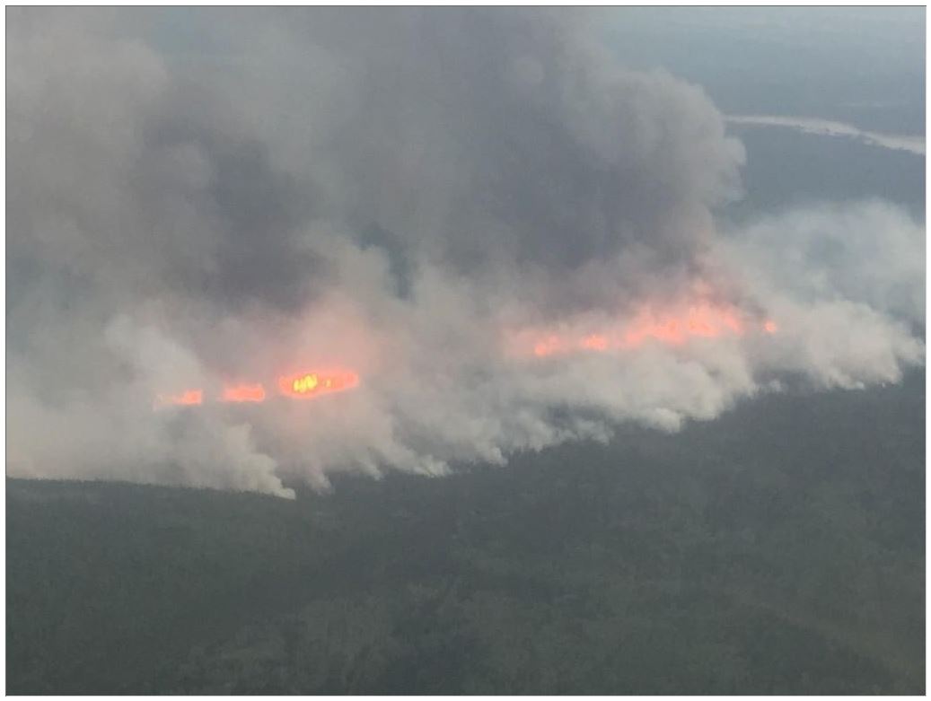
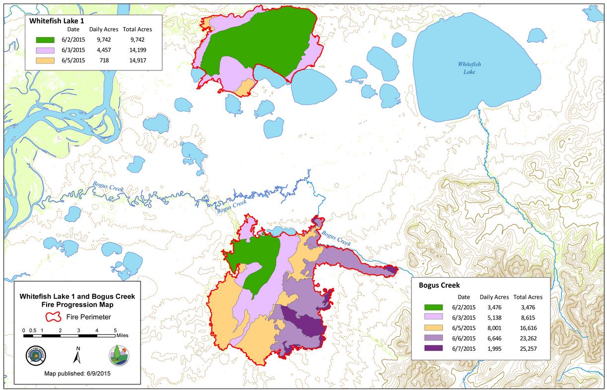
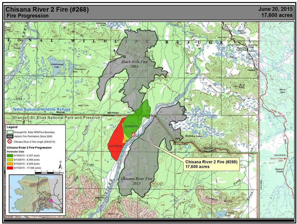
Large Wildfires in Alaska
Several
large wildfires continue in Alaska as warm and dry weather conditions
have prevailed. There are currently 4 wildfires that have consumed
10,000 to 20,000 plus acres, the biggest of which is the Chisana River 2
Fire that has consumed nearly 30,000 acres as of late Sunday.
(Images courtesy Inciweb)
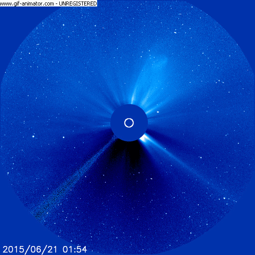
Northern Lights Potential
"A
coronal mass ejection (CME) is heading directly for Earth. It left the
sun during the early hours of June 21st, and is expected to sweep up one
or two lesser CMEs already en route, before it reaches Earth sometime
on June 22nd."
"NOAA
forecasters estimate a 90% chance of polar geomagnetic storms when the
CME arrives. This doesn't mean that a major space weather event is in
the offing. The storm could be mild. It all depends on how the magnetic
field of the CME connects to the magnetic field of Earth at the time of
impact. According to NOAA, there's only a 10% chance
of nothing happening, so stay tuned."
Thanks for checking in and have a great rest of your week! Don't forget to follow me on Twitter @TNelsonWX

No comments:
Post a Comment