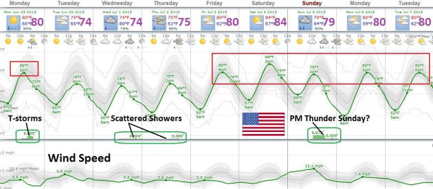
82 F. high in the Twin Cities Sunday.
82 F. average high on June 28.
83 F. high on June 28, 2014.
.10" rain fell at MSP International Airport yesterday.
4.3" rain so far in June, that's
.33" wetter than average for MSP, to date.
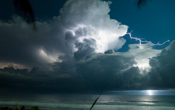
Summer Storm AngstWe
jam much of our outdoor plans into 4-5 months; a much-needed surge of
warmth also brings wild thunderstorms, especially the first half of
summer. I've had my fair share of harrowing weddings and grad parties in
June - the wettest - most severe month of the year.
"Paul, can't you make the rain stop?" No. I can't.
Lately
I've heard from soccer parents worried about coaches violating
lightning rules and one frantic sister in law, complaining about
"clueless teens" not keeping tabs on severe weather moving in.
What
can you do? Have a Doppler app on your phone. Alerts for warnings, too.
Try to schedule events for the morning or midday hours. The atmosphere
is most unstable around the dinner hour. That's when T-storms are most
likely to sprout.
Wait 30 minutes after the last thunderclap
before resuming your game or outdoor event. And don't be afraid to
postpone or cancel an event. Nothing is worth risking life and limb.
More
storms mushroom this afternoon in response to a cool pool of air
rotating overhead. The maps look more like early September than late
June; highs in the 70s to low 80s. Not a hot front in sight.
Plan on
sunny 80s on the 4th; a better chance of storms
Sunday.
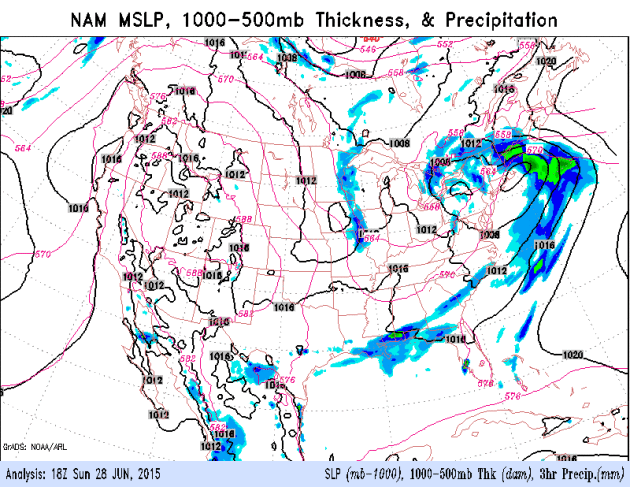
Whirlpool of Instability.
You can almost see the outline of a relatively cold pocket of air
swirling over eastern Minnesota and Wisconsin. Strong heating of the
ground created thermals, popcorn cumulus which mutated into cumulonimbus
Sunday afternoon and evening, packing heavy rain, half inch hail and
lightning. Typical for June. Sunday afternoon visible imagery loop: NOAA
and AerisWeather.
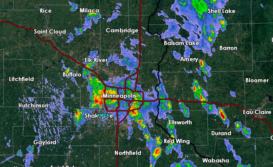 Definition of "Scattered T-storms".
Scattered storms implies about 10-35% coverage of precipitation, which
was the case late afternoon yesterday as strong storms bubbled up around
the metro. The NWS Doppler image above was saved at 4:17 PM Sunday.
Persistent Northwest Flow Aloft Keeps a Lid on Minnesota Temperatures.
More instability T-showers are likely again this afternoon and eveing,
but we may salvage dry weather Tuesday before another round of showers
and storms arrive midweek. Continuous puffs of cooler, drier, Canadian
air pushing into the northern USA will set up a persistent boundary, a
magnet for more showers and T-storms looking out the next 2 weeks. NAM
guidance: NOAA.
Downright Reasonable.
Considering we could easily be in the 90s now with dew point near 70
and neighbors whining about the humidity, this weather isn't too hard to
take. If you can dodge the late afternoon instability T-storms it
should be downright pleasant into next week. Dry weather is expected
Tuesday, again Friday and Saturday. The next frontal boundary pushes
more T-storms into Minnesota Sunday, but right now the 4th of July looks
very nice with warm sun and low to mid 80s. Can we really be that
lucky. Don't celebrate just yet.
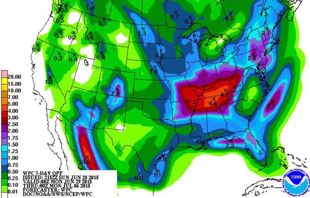 Wettest Zone Shifts into Ohio Valley.
A steady supply of cooler fronts of Canadia origin will push the main
frontal boundary capable of heaviest showers and T-storms into the
Middle Mississippi Valley and Ohio Valley. NOAA guidance shows some 4-6"
amounts possible there over the next week.
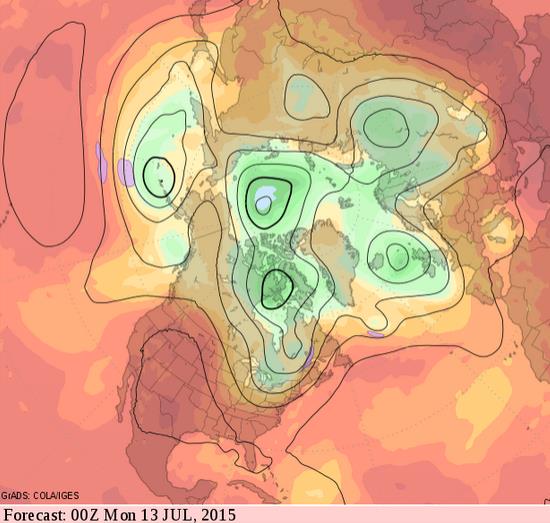
Canadian A/C.
Long range guidance valid Sunday evening, July 12 shows predicted winds
at 500 mb, courtesy of NOAA's GFS model. A persistent northwest flow
aloft keeps temperatures average to below average from the Upper
Mississippi Valley into the Great Lakes and New England. While the west,
Rockies and southwest continues to bake.
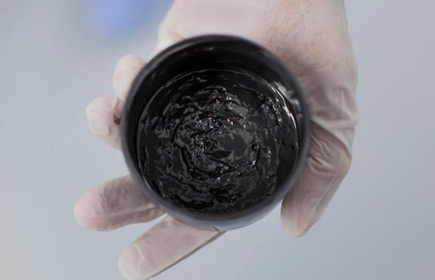
The Story Of The Invention That Could Revolutionize Batteries - And Maybe American Manufacturing As Well. Quartz has a
remarkable story
about a remarkable inventor in the Boston area and how he's trying to
disrupt the battery storage market. It's innovations like this that will
ultimately lead us to a cleaner-energy future. Here's an excerpt: "...
When
it starts commercial sales in about two years, Chiang says, his company
will slash the cost of an entry-level battery plant 10-fold, as well as
cut around 30% off the price of the batteries themselves. That’s thanks
to a new manufacturing process along with a powerful new cell that adds
energy while stripping away cost. Together, he says, they will allow
lithium-ion batteries to begin to compete with fossil fuels..."
Photo credit above: "
This black goop is what will be at the heart of the next generation of batteries."
(Kieran Kesner for Quartz).
TODAY: AM sunshine. PM T-storms pop up again. Winds: NW 10. High: 83
MONDAY NIGHT: Evening thunder, then clearing. Low: 63
TUESDAY: More sun, probably dry. Cooler. High: 78
WEDNESDAY: More showers and T-storms likely. Wake-up: 62. High: 76
THURSDAY: Shocker: more PM T-storms pop up. Wake-up: 60. High: 75
FRIDAY: Drier, Sticky sunshine. Dew point: 63. Wake-up: 59. High: 80
4th OF JULY: Cautiously optimistic. Warm sunshine. Wake-up: 66. High: 84
SUNDAY: Another round of T-storms arrives. Wake-up: 68. High: 81
Climate Stories...
The Pope's Ecological Vow. Here's an excerpt of an Op-Ed at
The New York Times that got my attention: "...
The
real problem, he insists, is the myopic mentality that has failed to
address climate change to date. The rich world’s indifference to the
despoliation of the environment in pursuit of short-term economic gain
is rooted in a wider problem. Market economics has taught us that the
world is a resource to be manipulated for our gain. This has led us into
unjust and exploitative economic systems that support what Francis
calls “a throwaway culture,” one that treats not just unwanted things
but also unwanted people — the poor, the elderly and the unborn — as
waste..."
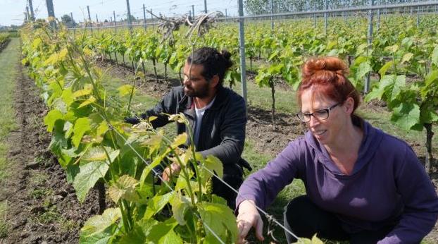
Sweden's Wine Industry is Maturing Nicely, Thanks to Climate Change. A fine Swedish wine? Don't laugh - it's coming, and soon. Here's an excerpt from
NDTV Food: "...
The
rise in temperatures in the country has been roughly twice the global
average change since the late 1800s, leading to summer heatwaves and
winters milder by almost 2C, according to Sweden’s Rossby Centre
for climate research. The change is helping to turn Nordic viniculture
from a retirement hobby into a small but resilient commercial reality –
there are more than a dozen vineyards selling to the country’s alcohol
stores, while many more have created businesses around their wine..."
Photo credit above: "
Murat Sofrakis and Lena Jorgensen in the Klagshamn vineyard." Photo: David Crouch.
Climate Marchers Gather To Show Rousing Support for Pope. Here's an excerpt from
The New York Times: "...
This
pope is giving voice to a sentiment that is growing in all faiths
around the world,” Father Harper said. “We need all people in leadership
positions to go decisively on the record about the need for deep
change.” The encyclical is by far the most forceful contribution on the
topic by a pope, who has the ear of more than one billion Roman
Catholics, and whose personal warmth has endeared him to many outside
his faith..." (File photo: AP).
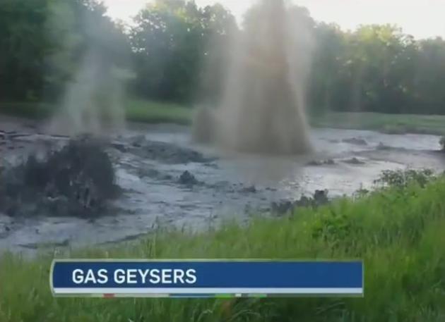
Ontario, We Have a (Methane) Problem. Not exactly what you want to see when you hit the local golf course in Lambton Shores, Ontario. Check out the amazing
YouTube video: "
Natural gas geysers are bubbling up at a golf course in Lambton Shores. The town has called a state of emergency."
UNM Researchers Study Global Warming Causes. Portions of Central America have been drying over the last few centuries, but why? Here's an excerpt from
KRQE News 13: "
For
decades, it has been getting drier in some parts of Central America
that have traditionally enjoyed plentiful tropical rains. Some
University of New Mexico researchers say that is because of air
pollution during the industrial age causing uneven warming of the
northern and southern hemispheres. They and their colleagues on an
international science team say the uneven heating of the northern and
southern hemispheres is nudging the inter-tropical convergence zone,
where tropical rains form, to the south. “What we’ve noticed basically
over the last 500 years, especially since the advent of the industrial
age, is that the region has been getting drier and drier, relatively,”
said Professor Yemane Asmerom of UNM’s Earth and Planetary Sciences..."


No comments:
Post a Comment