78 F. high in the Twin Cities Monday.
79 F. average high on June 15.
76 F. high on June 15, 2014.
June 15, 1989: Scattered frost across Minnesota with the cold spot at Isabella with 29.
June 15, 1892:
An estimated F5 tornado struck just north of the MN/IA border, killing
9. Large house timbers were found embedded in the ground three miles
away from their foundations.
In Search of "Perfect""Have
no fear of perfection - you'll never reach it" said Salvador Dali.
Where is the perfect place to visit or retire, a 21st century Garden of
Eden with no weather drama? Good luck finding it.
California
comes close, but it's running out of water - in the midst of historic
drought. Arizona is sunny, but to paraphrase Sam Kinnison "You're living
in a DESERT!" Florida? Too many storms with names. Hawaii comes very
close, in spite of island fever and high prices. Seattle? Perfect, for
drizzle-lovers.
It's probably human nature to want what you can't
have. I like the changing of the seasons and traditions that come with a
vibrant climate. Never a dull moment here.
Minnesota's weather
can be maddening, but be glad you're not stranded in Texas, for many
reasons. A tropical storm sweeping in off the Gulf of Mexico may drop
some 10 inch rainfall amounts from Houston and Dallas to Tulsa; severe
flooding possible hundreds of miles inland.
Comfortable sun fades by afternoon, half an inch or more of rain here
on Wednesday. A swarm of T-storms returns
Friday and
Saturday; a few may turn severe. ECMWF guidance prints out 2.3 inches of rain by
June 25.
Mostly-warm and partly-soggy. Yep, almost perfect.
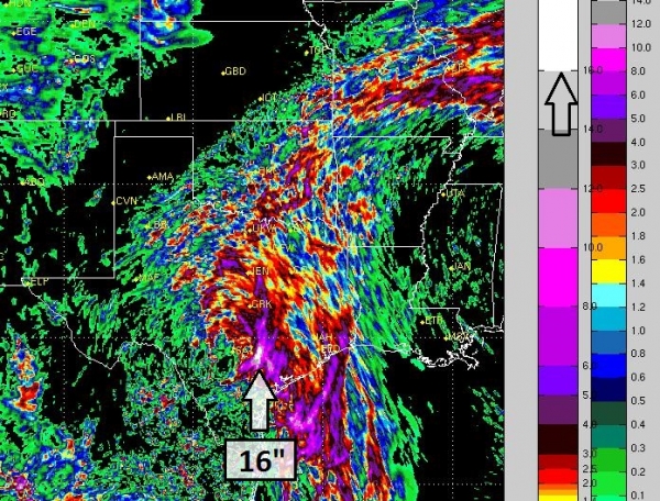
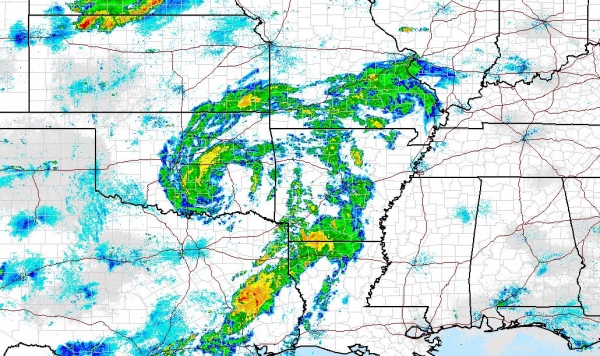
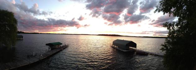
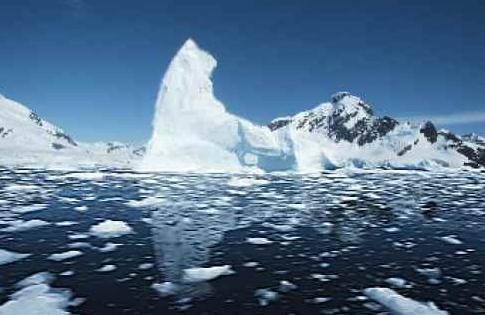
* photo credit above: Pete Kreshitour.
Alerts Broadcaster Update: Issued Monday evening, June 15, 2015.
*
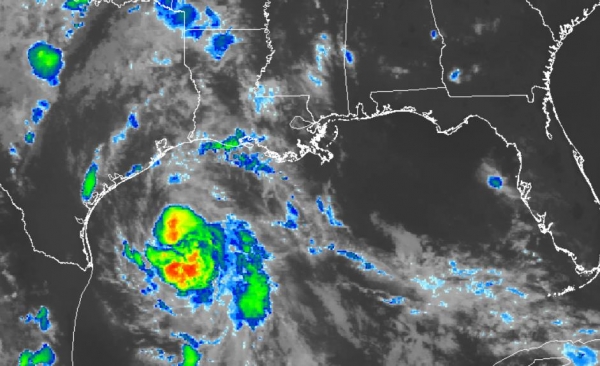
As expected, the tropical disturbance in the Gulf of Mexico has
strengthened into Tropical Storm Bill, with sustained winds of 50 mph.
*
The main threat is still excessive rainfall capable of more historic to
catastrophic flooding across Texas and Oklahoma Tuesday and Wednesday,
but
severe flooding will extend many hundreds of miles inland, days after landfall.
* Latest model guidance suggests eventual flooding impacts may be greatest inland, closer to San Antonio and Austin.
Tropical Storm Bill.
The storm in the Gulf of Mexico continues to gain strength and may hit
the coastline of Texas Tuesday with sustained winds of 60 mph. The odds
of Bill reaching hurricane status tless than 1 in 3. Latest statistics:
SUMMARY OF 1000 PM CDT...0300 UTC...INFORMATION
-----------------------------------------------
LOCATION...27.1N 94.2W
ABOUT 160 MI...260 KM ESE OF PORT OCONNOR TEXAS
ABOUT 155 MI...250 KM SSE OF GALVESTON TEXAS
MAXIMUM SUSTAINED WINDS...50 MPH...85 KM/H
PRESENT MOVEMENT...NW OR 320 DEGREES AT 12 MPH...19 KM/H
MINIMUM CENTRAL PRESSURE...1005 MB...29.68 INCHES
A Tropical Storm Warning is in effect for...
* Baffin Bay to High Island Texas
RAINFALL:  Bill is expected to produce total rain accumulations of 4
to 8 inches over eastern Texas and eastern Oklahoma and 2 to 4
inches over western Louisiana and western Arkansas, with possible
isolated maximum amounts of 12 inches in eastern Texas.

WIND:  Tropical storm conditions are expected to first reach the
coast within the warning area tonight.

STORM SURGE:  The combination of a storm surge and the tide will
cause normally dry areas near the coast to be flooded by rising
waters.  The water could reach the following heights above ground if
the peak surge occurs at the time of high tide...

Upper Texas coast...2 to 4 feet
Western Louisiana coast...1 to 2 feet
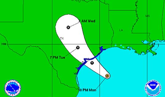
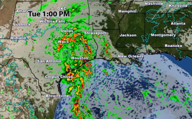
Projected Path.
The map above shows the latest National Hurricane Center estiminate of
where the storm center will track. Historically the heaviest rains fall
along and to the right (east) of the storm track. The relatively slow
forward motion of "Bill" will prolong heavy rain, with some isolated 12"
amounts possible, especially closer to San Antonio and Austin. Map:
NOAA NHC.
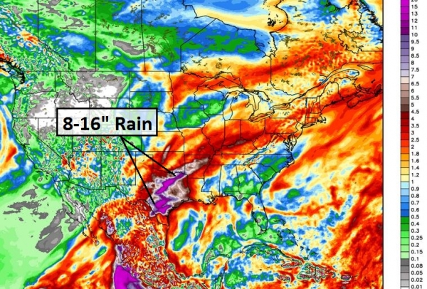
Tropical Storm's Worth of Rain for the Ohio Valley?
NOAA's HWRF hurricane model prints out some excessive 5-10" rains by
Thursday or Friday as far away as St. Louis, Champaign-Urbana,
Indianapolis, Dayton and Columbus. Facilities nearly 1,000 miles inland
may be impacted by severe flooding, days after landfall. Source:
WeatherBell.
GFS Model: 2-3 Month's Worth of Rain in 48-60 Hours.
GFS guidance confirms excessive rains, hinting that Oklahoma City and
Tulsa may pick up as much, or even more rain than portions of central
and eastern Texas. Other major metro areas that may be impacted by
severe flooding later this week include St. Louis, Evansville and
Louisville.
Greater Flood Risk for San Antonio and Austin than Houston?
This is still very speculative, but late evening runs of
high-resolution weather models show some 12-16" rainfall amounts over
the next 40 hours near San Antonio. If this verifies (still a big if)
subsequent flooding could be catastrophic. The reality: it's still
terribly difficult isolating exactly where thunderstorms will stall and
"train", new storms popping up replacing old storms, tracking repeatedly
over the same counties. Metro Houston will experience at least 3-6" of
rain, which will spark moderate to major flooding, possibly rivaling the
problems of 3 weeks ago. But I'm starting to believe that the most
extreme rains and floods will come farther inland, from San Antonio and
Austin northward to Abilene, Wichita Falls and the Dallas-Fort Worth
Metroplex. Severe flooding will probably extend into Oklahoma City and
Tulsa by Tuesday Wednesday. RPM guidance: WSI
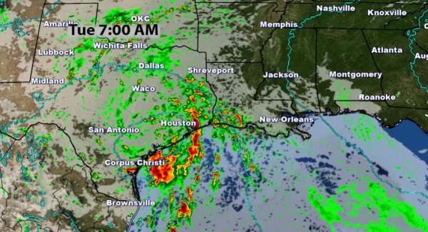
Timing The Next Wave of Flooding.
NOAA's NAM model brings the first surge of heavy showers and T-storms
into Texas as early as this evening. the heaviest rains may fall from
Houston to Dallas and Oklahoma City Tuesday into Wednesday morning.
Forecast model maps: AerisWeather.
Battening Down The Hatches.
NWS Doppler radar at 10 PM Central shows a few initial spiral bands of
heavy showers and T-storms approaching the coast, but the core of the
storm, and some of the heaviest rains, are still 12-18 hours away. Texas
state officials released
weather safety tips for Texas residents:
- Assemble
an emergency kit that includes essential documents, supplies and
provisions; plan how all family members and pets will respond in case of
evacuation.
- Consider any special needs for individuals with disabilities or the elderly.
- When severe storms threaten, the safest place to be is indoors. If you are outdoors, seek shelter in a home or large building.
- Avoid
areas already flooded and avoid any fast-flowing water; keep in mind
that flood dangers are even harder to recognize at night.
- Be
extremely cautious of any water on roads or in creeks, streams, storm
drains or other areas – never attempt to cross flowing streams or drive
across flooded roadways – and always observe road barricades placed for
your protection.
- Remember that dangerous waters can seem deceptively calm, and if you encounter flooding, move to higher ground.
- Monitor weather radios and news broadcasts for updated information on current and anticipated severe weather.
- Always heed warnings and instructions provided by local officials and emergency management personnel.
Summary:
We are closely monitoring the evolution of Tropical Storm Bill. Major
to historic, even catastrophic flooding is possible for portions of
Texas and Oklahoma. The recent I'm mentioning catastrophic is due to the
obvious: May was the wettest on record for Texas and Oklahoma. Soil is
waterlogged, saturated. Any additional heavy rain will quickly result in
run-off and urban and river flooding. Although the short-term threat is
greatest for Texas and Oklahoma facilities from Joplin and St. Louis to
Louisville, Indianapolis and Columbus should track the movement of
Bill's soggy remains. I expect very significant flooding well inland,
days after landfall.
Paul Douglas, AerisWeather Senior Meteorologist
Hurricane Forecasters Struggle To Make Sense of Social Media.
There is so much clutter, noise and nonsense on Twitter, FB, Instagram,
Snapchat - people commenting on comments. Which is all good fun until a
deadly storm is approaching. And then who are you going to believe, a
spokesman for The National Hurricane Center, or some (idiot)
second-guessing the official track of the storm? It's a free country,
you can say what you want, believe what you want. Even if it gets you
killed. Here's an excerpt of an interesting article at
PalmBeachPost.com: "
Social
media is an effective way to keep tabs on Katy Perry or stalk your ex,
but how does it fare when a life-threatening emergency arises? Hurricane
forecasters don’t seem keen on Twitter, Facebook and Instagram as
emergency-management tools, the Post’s Eliot Kleinberg reports from the National Hurricane Conference.
They fret about the dilution of the old media model of news delivered
straight from the experts’ mouths to your eyes and ears..."
Wet, But Not "Texas Wet".
And to think just a few months ago the state of Texas was experiencing
severe to exceptional drought. Expect some sun today but clouds increase
by afternoon, another round of showers later tonight into Wednesday. We
warm up a bit late in the week with strong to potentially severe
T-storms Friday into Saturday.
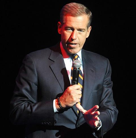
Here's What NBC Can And Can't Do With Brian Williams.
Vanity Fair has an update; here's an excerpt: "...
After
a flurry of media leaks, it appears Williams will not be returning to
his old job at NBC Nightly News. The burning question now becomes if, as
multiple media reports indicate, NBC really does want to keep Williams
at the network in some other capacity, what on earth should they do with
him? It’s a daunting problem, and one that the news division’s new
chief, longtime Williams friend Andrew Lack, has, by most accounts, had
his people studying for weeks. Lack’s directive, according to a report
by CNN’s Brian Stelter, has been to “think creatively,” suggesting that
almost any role other than the anchorman at Nightly News is on the
table..." (File photo: Brad Barket/Invision/AP, File).
Music Is Free Now - And The Industry Only Has Itself To Blame.
NewStatesman takes a look at something that would have seemed unthinkable as recently as the 1990s - here's a clip: "...
Stephen
Witt’s How Music Got Free details decades of foolishness in the
industry and its decline in the 21st century by focusing on three
simultaneous developments: the construction and massive growth of the
Universal label, Brandenburg’s efforts to get the MP3 taken seriously
and the contemporaneous development of the internet, on which a tiny
group of hip-hop fans and computer geeks slowly dismantled a
multimillion-pound industry..."
Image credit above: "
Sound investment: the history of the record industry is a tale of technology, stars and shady deals." Photo Montage by Dan Murrell.
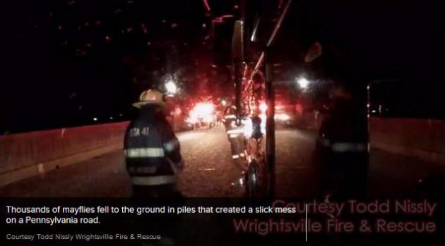
"Blizzard" of Mayflies Closes Bridge in Pennsylvania. ABC News has the gag-worthy details: "
It
was a scene straight from a nightmare. A town in Pennsylvania was
invaded by swarming mayflies on Saturday night, causing three separate
motorcycle accidents and closing a bridge for several hours, fire chief
Douglas Kemmerly told ABC News today. The Wrightsville Fire Department
responded to a motorcycle crash along the Veterans Memorial Bridge
between the towns of Columbia and Wrightsville. Firefighters and police
were bombarded by nickel-sized mayflies that turned the sky into a “blizzard,” Kemmerly said..." ) Photo credit: Todd Nissly, Wrightsville Fire & Rescue).
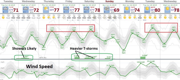
TODAY: Fading sun, quite comfortable for June. Dew point: 49. Winds: E 5-10. High: 73
TUESDAY NIGHT: Cloudy with showers developing late. Low: 61
WEDNESDAY: Cool with showers likely, locally heavy rain possible. High: near 70
THURSDAY: Plenty of sun, very pleasant. Wake-up: 60. High: 78
FRIDAY: T-storms likely, a few may be severe. Wake-up: 62. High: 81
SATURDAY: Still unsettled - showers and T-storms, sticky. Wake-up: 64. High: 80
SUNDAY: Unsettled, a few PM showers. Wake-up: 61. High: 75
MONDAY: Warm sunshine, late night thunder? Wake-up: 59. High: 78
Climate Stories...
Confronting Climate Change: Science, Education and Solutions. Climate
Generation; a Will Steger Legacy is putting on a free presentation at
the Science Museum in St. Paul this evening, featuring noted climate
scientist and IPCC contributor Ben Santer. If you're interested in the
topic and you have some time this evening the program runs from 7 PM to 9
PM.
Details here: "
Keynote
speaker Ben Santer is a climate researcher at Lawrence Livermore
National Laboratory, specializing in the statistical analysis of climate
data sets and the identification of human factors in climate variables.
Santer received a Bachelor of Science in Environmental Sciences at the
University of East Anglia, where he also holds a Ph.D in Climatology
from its Climatic Research Unit. He served as convening lead author of
the climate-change detection and attribution chapter of the 1995 IPCC
report..."
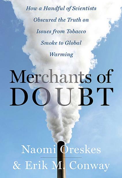
Naomi Oreskes, a Lightning Rod in a Changing Climate. Justin Gillis has the story at
The New York Times; here's a snippet: "...
Her core discovery, made with a co-author, Erik M. Conway,
was twofold. They reported that dubious tactics had been used over
decades to cast doubt on scientific findings relating to subjects like
acid rain, the ozone shield, tobacco smoke and climate change. And most
surprisingly, in each case, the tactics were employed by the same group
of people. The central players were serious scientists who had major
career triumphs during the Cold War, but in subsequent years apparently
came to equate environmentalism with socialism, and government
regulation with tyranny..."
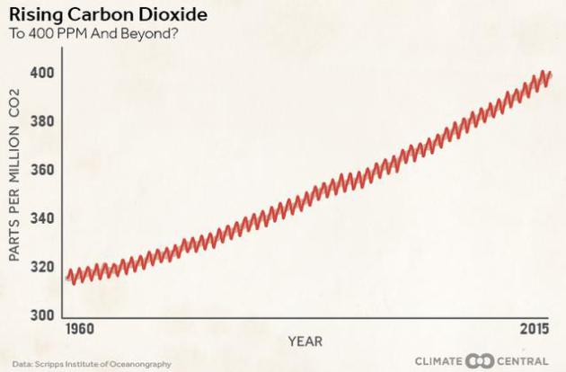
Iconic Keeling Curve Designated a Landmark. Here's more background from
Climate Central: "
The American Chemical Society has named the graph that charts that rise — called the Keeling Curve, so named after the scientist who began the CO2 measurements — as a National Historic Chemical Landmark. “The Keeling Curve is an icon of modern climate science,” Thomas J. Barton, the most recent past president of the ACS, said in a statement.
The recognition that CO2 levels were building in the atmosphere thanks
to human activities underpins the science of global warming..."
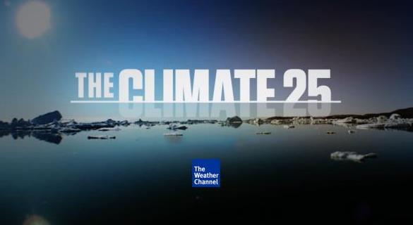
The Weather Channel Confronts Republicans on Climate Change. Eric Holthaus at
Slate takes a look at an ambitious new campaign to raise awareness - focused at conservatives; here's an excerpt: "...
The
series of short videos, called Climate 25, is surprisingly political
for a venue like the Weather Channel, and most are aimed at making the
case for urgent action from a conservative, Republican angle. Among the featured speakers
are U.S. Army Gen. Charles H. Jacoby (Ret.); Henry Paulson, a former
CEO of Goldman Sachs who served as secretary of the treasury under
President George W. Bush from 2006 to 2009; and Paul Polman, the CEO of
Unilever. At one point, Christine Todd Whitman, the EPA administrator
under George W. Bush, addresses Republicans directly, saying, “It’s our
issue...”
Climate Engineering Would Cool Down The Climate - But It May Not Save West Antarctica. Chris Mooney at
The Washington Post
takes a look at geoengineering our way out of a warming climate, and
the potential impact on West Antarctica; here's a clip: "...
But it’s
also very risky — there are many possible unintended consequences of
geoengineering. Thus, the only reason to really consider it is if you’re
on the verge of climate impacts so severe — impacts like, say, the
potential collapse of the West Antarctic ice sheet, leading to 10 or more feet of global sea level rise — that it becomes the lesser evil. That’s why a new study
recently accepted in Geophysical Research Letters could be so
significant. For it calls into question whether geoengineering — at
least using sulfate aerosols — can actually save this ice sheet, which
is already beginning to be destabilized in our warming world..."
* the research abstract referenced above is
here.
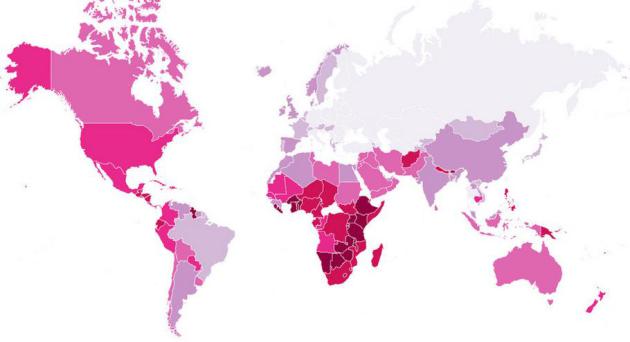
These Are The Countries Most and Least Interested in Climate Change.
Mashable takes a look; here's an excerpt: "...
The countries with the lowest climate change-related search volume are Syria, Yemen, Ukraine, Russia and Iraq. Syria, where drought played a role
in leading to the country's current civil war, may rank low partly
because ongoing fighting has led to intermittent power outages in
Damascus and elsewhere. The two highest-ranked cities for climate-based
searches are both in the Philippines, which is currently the world's
most disaster-prone country. With frequent flooding in Manila, massive
typhoons and volcanoes, the Philippines is becoming an emerging player
in global climate talks..."
Paris
2015: The Harvests Are Coming Earlier, The Snow-Line Is Retreating,
French Nonchalance Is Being Tested By A Warming Climate. Here's an excerpt from
The Sydney Morning Herald: "...
But
in the meantime, signs of change are becoming ever more evident. In the
Bordeaux region of south-west France, grape vines – long known to be a
useful biological gauge of climate – are being harvested about two weeks
earlier than 20 years ago, Planton says. Other regions are seeing
similar shifts in the grape season, such as In the Champagne
industry around Reims, about 150km north-east of Paris. There, the
important flowering of vines has started 10 days earlier over recent
decades..."
The World Is Off Course To Prevent 2 Degrees C of Warming, Says Energy Agency. Chris Mooney reports at
The Washington Post; here's the intro: "
In
a major report to be released Monday, the Paris-based International
Energy Agency — which provides independent energy analysis and has 29
member countries, including the United States — will state that current
national commitments to cut greenhouse gases are ambitious but still
insufficient to keep the world below two degrees Celsius of warming
above preindustrial levels. At the same time, the agency will also offer
a path forward, showing how the world, with a bit more ambition, could
peak its emissions by the year 2020 and get onto a safer path..." (File image: NASA).
Collapse of Ancient Ice Sheet Triggered Global Climate Change Events. Not all ice ages are created equal. Here's a clip from a story at
Design & Trend: "...
To
our surprise, the sequence of climate events 135,000 years ago looks
very different from what happened at the end of the last ice age, about
20,000 to 10,000 years ago," study lead author Dr. Gianluca Marino, of
The Australian National University, said in a statement.
"Ice-ages may superficially look similar to one another, but there are
important differences in the relationships between the melting of
continental ice sheets and global climate changes..."


No comments:
Post a Comment