85 F. high in the Twin Cities Sunday.
79 F. average high on June 14.
66 F. high on June 14, 2014.
June 14, 1981: Tornado hits Roseville, destroying homes and damages Har Mar Mall.
June 14, 1956: 8 inches of rain fell in the Ivanhoe area in 3 and a half hours. 100 thousand dollars in damage to crops.
June 14, 1943: Torrential downpours cause flooding in the Twin Cities and east central Minnesota. 2.5 inches of rain fell in St. Paul in two hours. In addition, four streetcars were hit by lightning.
Energized
This is my favorite time of year, just before the dog days, wilting humidity and kamikaze-mosquitoes. I have a lot more energy in June, which may have something to do with 15 hours and 35 minutes of daylight.
Almost 2 hours more than Miami. A far cry from December 21, when a reluctant sun sneaks above the horizon for a meager 8 hours and 46 minutes.
Staring at the morning weather map I am struck by 2 things: a real summer (defined as an extended streak of 80s and 90s with gasp-worthy humidity levels) is nowhere to be found, looking out through the first week of July. A series of cool fronts dribbling out of Canada keep any sauna-like heat and humidity well south of Minnesota for at least 2, maybe 3 weeks. These transfusions of almost September-like air set up persistent frontal zones capable of frequent showers and T-storms. I see a wet, cooler-than-average bias through the 4th of July.
The other gob-smacking trend: flood-plagued Texas and Oklahoma are about to get a visit from "Bill". As of Sunday evening NOAA NHC had raised the risk of cyclone formation to 70 percent. A plume of tropical moisture arrives by Tuesday with some 5-10 inch rains and more extreme flooding.
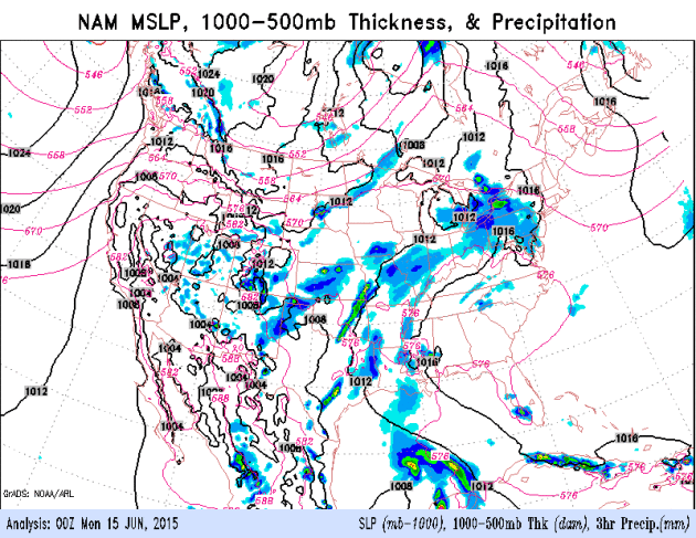

* Growing risk of tropical storm formation in the Gulf of Mexico, with heavy rain and flash flooding (and river flooding) impacting Texas and Oklahoma the first half of this week.
* National Hurricane Center: 60% probability of Tropical Storm Bill within 48 hours.
* Inland flooding potential from southern Plains into Corn Belt later this week - impacts possible as far away as St. Louis and Indianapolis.
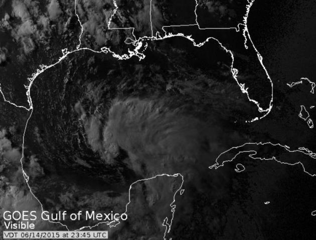
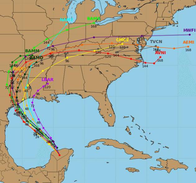
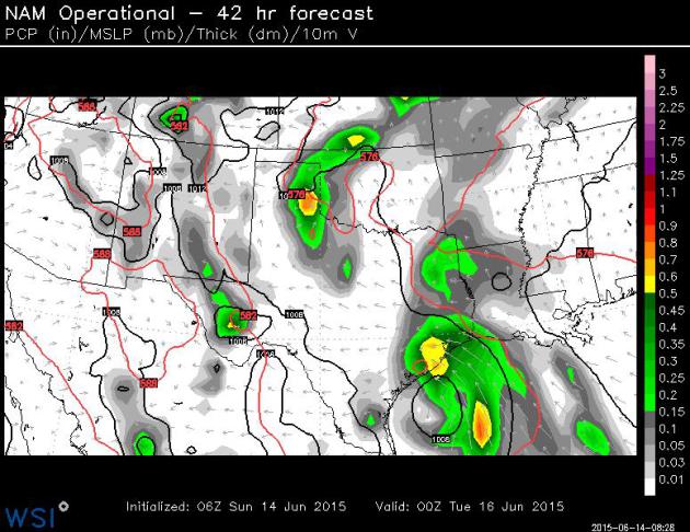
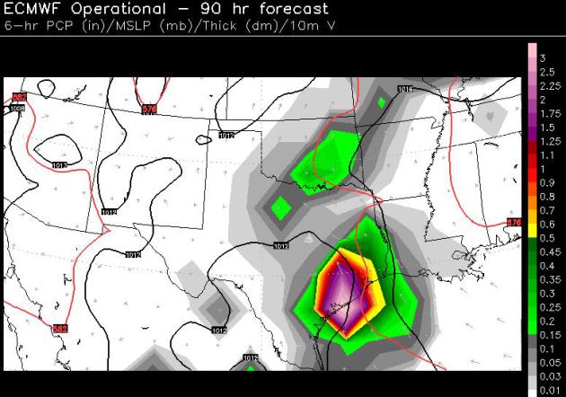
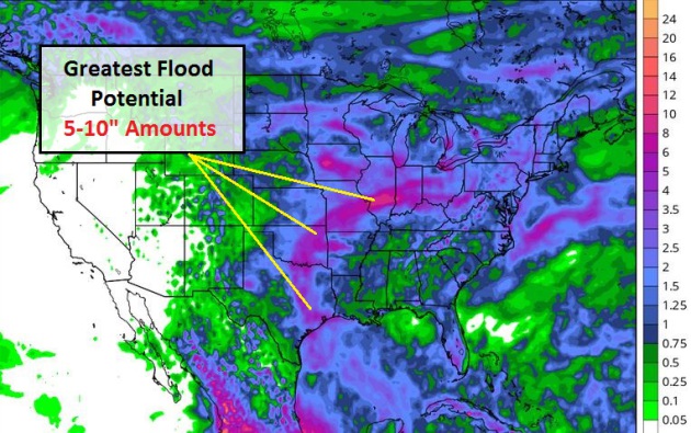
Summary: It's that time of year again. A high sun angle has heated up the Gulf of Mexico, and in spite of El Nino (which tends to hamper tropical development by creating consistently stronger winds high above the tropics) it appears that conditions favor tropical development in the Gulf of Mexico. Factoring in recent (extreme) rains across much of Texas and Oklahoma we are sending out this briefing, raising the very real scenario of more extensive flooding as (Bill) comes ashore sometime Tuesday or Wednesday. Areas that were flooded a few weeks ago may flood again, with rainfall amounts reaching 5-10" in some areas along and east of the tropical track. We'll keep you posted.
Paul Douglas. Senior Meteorologist, AerisWeather
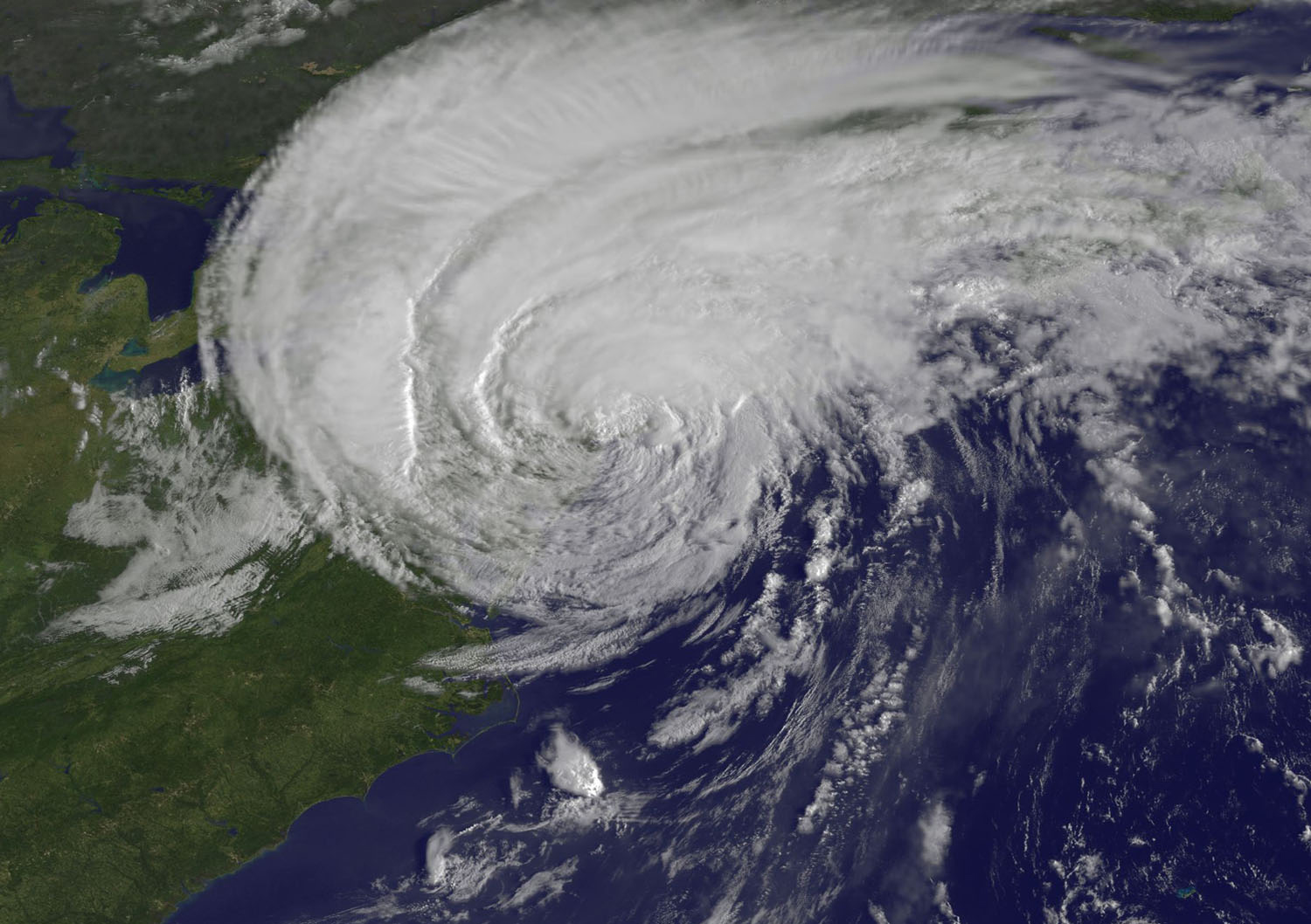
Hurricane Forecasters Struggle To Make Sense of Social Media. There is so much clutter, noise and nonsense on Twitter, FB, Instagram, Snapchat - people commenting on comments. Which is all good fun until a deadly storm is approaching. And then who are you going to believe, a spokesman for The National Hurricane Center, or some (idiot) second-guessing the official track of the storm? It's a free country, you can say what you want, believe what you want. Even if it gets you killed. Here's an excerpt of an interesting article at PalmBeachPost.com: "Social media is an effective way to keep tabs on Katy Perry or stalk your ex, but how does it fare when a life-threatening emergency arises? Hurricane forecasters don’t seem keen on Twitter, Facebook and Instagram as emergency-management tools, the Post’s Eliot Kleinberg reports from the National Hurricane Conference. They fret about the dilution of the old media model of news delivered straight from the experts’ mouths to your eyes and ears..." (Hurricane Irene image: NASA).
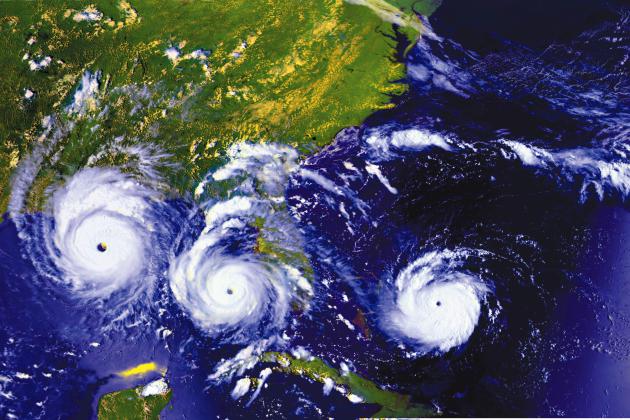
Blown Away: Wind Tunnel Highlights Hurricane Dangers. A story at USA TODAY
about recreating the effects of hurricane winds has a good reminder:
1992 was an El Nino year, but it produced Category 5 Hurricane Andrew,
which ravaged south Florida. All it takes is one. Here's an excerpt: "...However,
if we look back to 1992, that was the hurricane season of Hurricane
Andrew, and that was also another El Niño year," he said. "All it takes
is one hurricane to come ashore and do devastation."
Another catastrophic storm was Hurricane Katrina, which will mark its
10th anniversary this year. That massive system killed more than 1,800
people and caused more than $100 billion in damage..." (1992 Hurricane Time Lapse: NOAA).
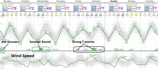
TODAY: Morning showers, then clearing. Winds: N 10-15. High: 79
MONDAY NIGHT: Clear and more comfortable. Low: 57
TUESDAY: Comfortable with fading sun. T-showers may arrive Tuesday night. High: 74
WEDNESDAY: Showers and T-storms likely. Wake-up: 59. High: 71
THURSDAY: A risk of sunshine. Soak it up. Wake-up: 61. High: near 80
FRIDAY: A few strong T-storms? Dew point: 62. Wake-up: 63. High: 81
SATURDAY: Heavy showers and T-storms. Wake-up: 66. High: 82
SUNDAY: Morning sun, PM T-showers. Wake-up: 64. High: 77
Climate Stories...


Pope Francis To Explore Climate's Effect on World's Poor. The New York Times reports; here's an excerpt: "...By
wading into the environment debate, Francis is seeking to redefine a
secular topic, one usually framed by scientific data, using theology and
faith. And based on Francis’ prior comments, and those of influential
cardinals, the encyclical is also likely to include an economic critique
of how global capitalism, while helping lift millions out of poverty,
has also exploited nature and created vast inequities. “We clearly need a
fundamental change of course, to protect the earth and its people —
which in turn will allow us to dignify humanity,” Cardinal Peter Turkson
of Ghana, who oversaw the drafting of the encyclical, said at a conference on climate change this spring at the Vatican..."

No comments:
Post a Comment