Road Trip
By Paul Douglas
"Peculiar travel suggestions are dancing lessons from God" wrote Kurt Vonnegut. We're all in our bubbles; most days scripted, rehearsed - morbidly predictable. True spontaneity is a luxury, it seems.
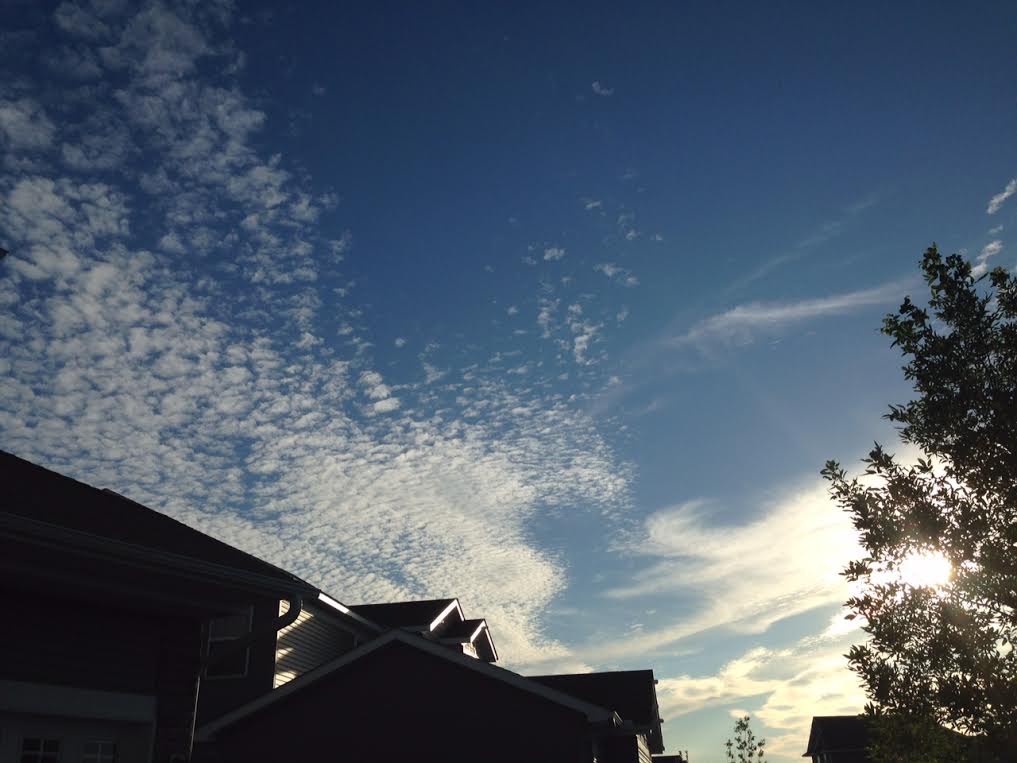
My oldest son and I just drove a moving van to Seattle - a straight shot down I-94 and I-90. We drove into a derecho in North Dakota; it rained so hard water was coming INSIDE the cab! You haven't lived until you've visited The Burger Dive in Billings, Montana, or seen the Northern Lights from Coeur d'Alene, Idaho, or coaxed an overheating truck up Snoqualmie Pass, Washington. That said - it's always good coming home.
How does it feel to be average? That's a compliment, by the way. The Pacific Northwest is sizzling through a heat wave while the Northeast endures flooding rains into the weekend. While we enjoy warm sunshine, low to mid 80s, reasonable humidity, a risk of bumping into few a thunderstorms Saturday night and early Sunday.
BTW, Minnesota has seen 10 tornadoes so far in 2015, according to SPC - fewer than average, to date.
Long range models hint at sizzling 90s the second week of July. Until then occasional burps of fresh Canadian air will provide some free A/C.
__________________________
THURSDAY NIGHT: Partly to mostly cloudy and quiet. Low: 62. Winds: N 5.
FRIDAY: Luke-warm. Late day T-storm possible. High: 79. Winds: ENE 5-10.
FRIDAY NIGHT: Partly cloudy and quiet. Low: 63. Winds: N 5.
SATURDAY: Warm sun, nighttime T-storms. High: 84.
SUNDAY: Morning storms, some PM sun. Wake-up: 65. High: 80.
MONDAY: Still unstable, a few PM T-storms. Wake-up: 64. High: 82.
TUESDAY: Warm sunshine, pool-worthy. Wake-up: 63. High: 83.
WEDNESDAY: Showers and T-storms, some heavy. Wake-up: 65. High: 78.
THURSDAY: Sunny and comfortable. Wake-up: 66. High: 77.
___________________________
This Day in Weather History
June 26th
1982: Cold spell. Kulger Township dips to 31 degrees. Duluth registers 36.
____________________________
Average High/Low for Minneapolis
June 26th
Average High: 82F (Record: 99F set in 1931)
Average Low: 62F (Record: 46F set in 1926)
______________________________
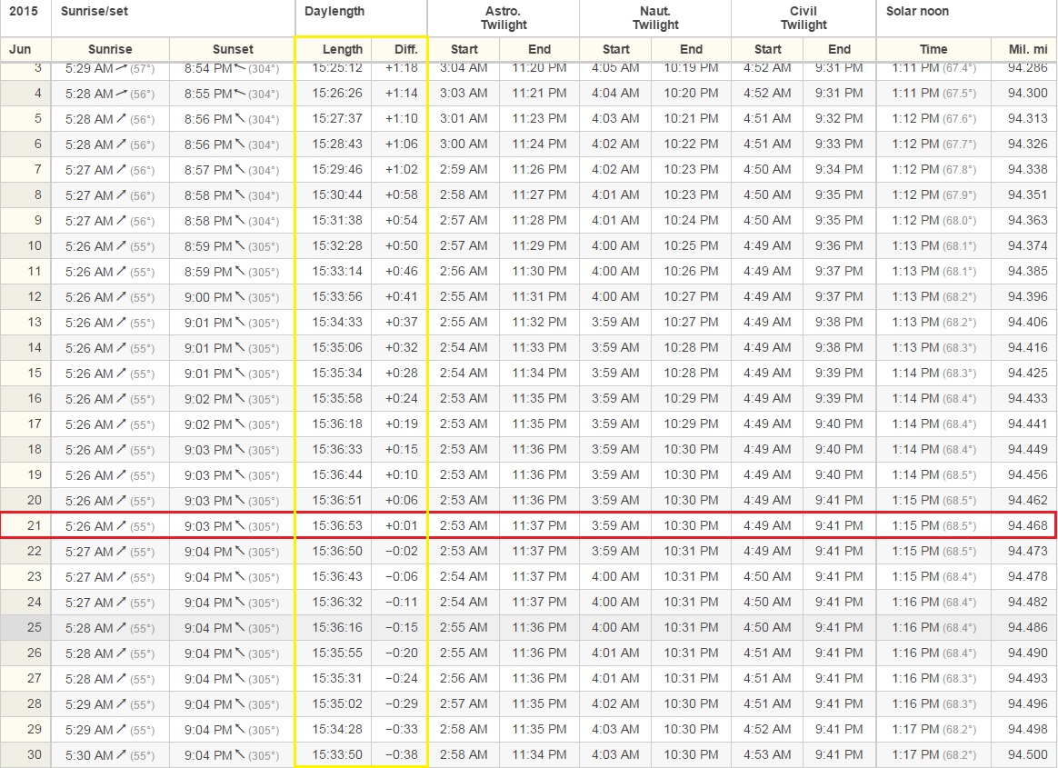
Sunrise/Sunset Times for Minneapolis
June 26th
Sunrise: 5:28am
Sunset: 9:03pm
By June 26th, we will have lost nearly a full minute of daylight since the Summer Solstice on Sunday, June 21st. The table below is courtesy Timeanddate.com
______________________________
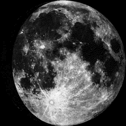
Moon Phase for June 26th at Midnight
2.8 Days Since First Quarter
_______________________________
Minneapolis Temperature Trend
The forecast calls for continued mild, but near average temperatures through much of the rest of the month and perhaps into early July. Heading closer to the 4th of July weekend, a slightly bigger cool down may be in store with highs dipping to below average levels. Stay tuned.

_______________________________
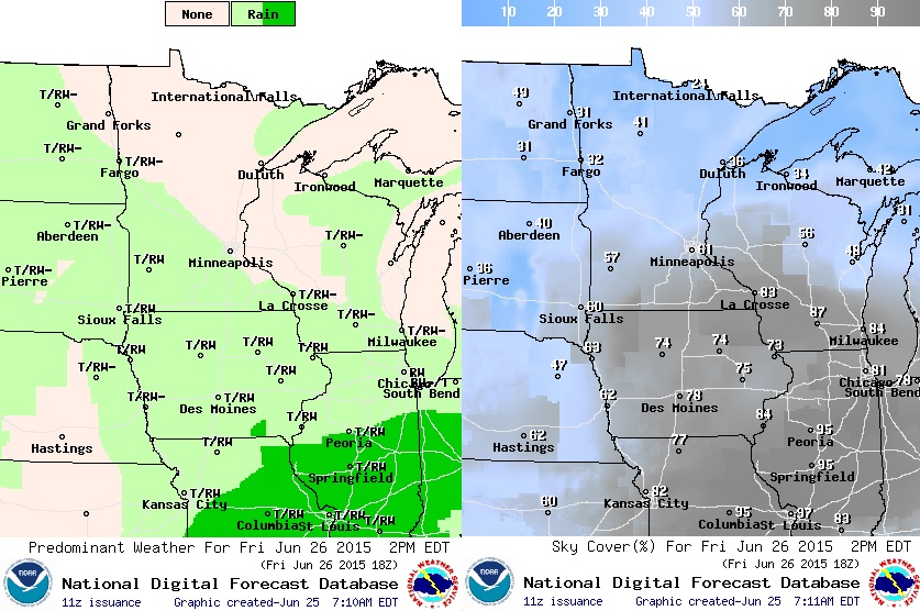
Friday Weather Outlook
I'm sure the complaint department is at near record low volume about now. With several days of quiet, near average temperatures in early summer, it's hard to complain about anything the way the weather is now.
Friday Weather Outlook
There's a slight chance a few spotty showers and storms could pop up late Friday across the southwestern part of the state, but it won't be a washout by any means. Much of the state will be precipitation free once again.
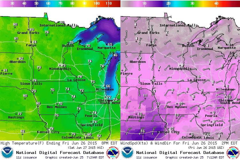
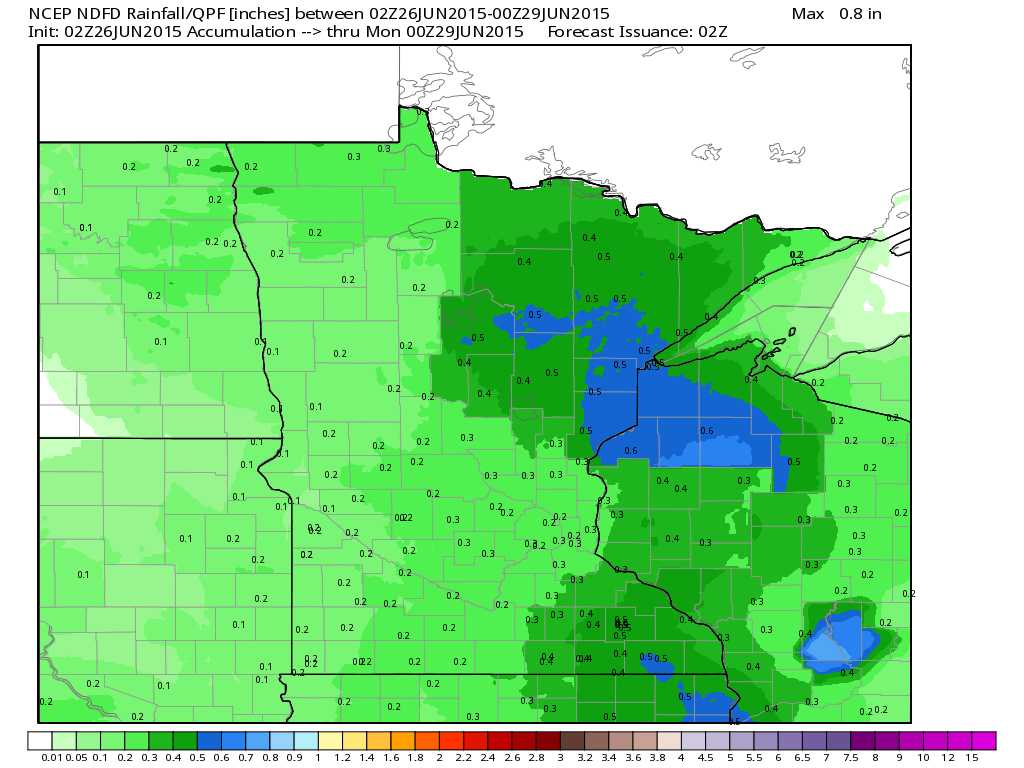
Rainfall Outlook
Much of Minnesota looks to stay dry until the second half of the weekend. An impulse of energy will help to produce pockets of heavier rainfall potential across parts of the region.
_________________________________
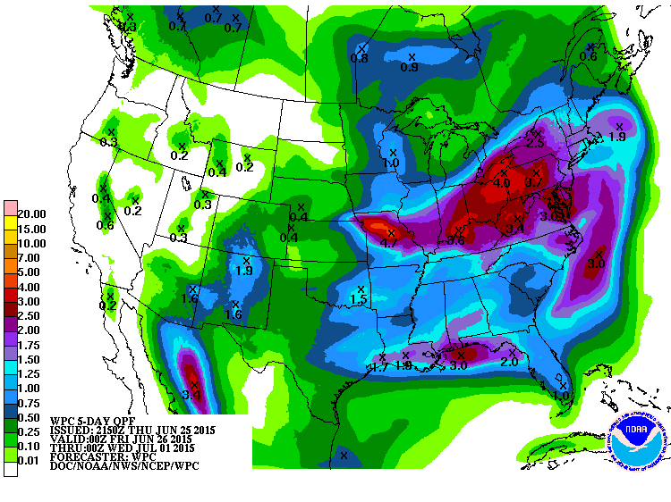
National Weather Outlook
The next impulse of energy working through the eastern part of the country will continue a severe weather and flooding rain threat through the first part of the weekend.

5 Day Precipitation
According to NOAA's HPC, the 5 day precipitation forecast suggests several inches of rainfall across the eastern U.S. through early next week. Parts of the Ohio Valley and Northeast could potentially see 2" to nearly 4" of rain.
____________________________
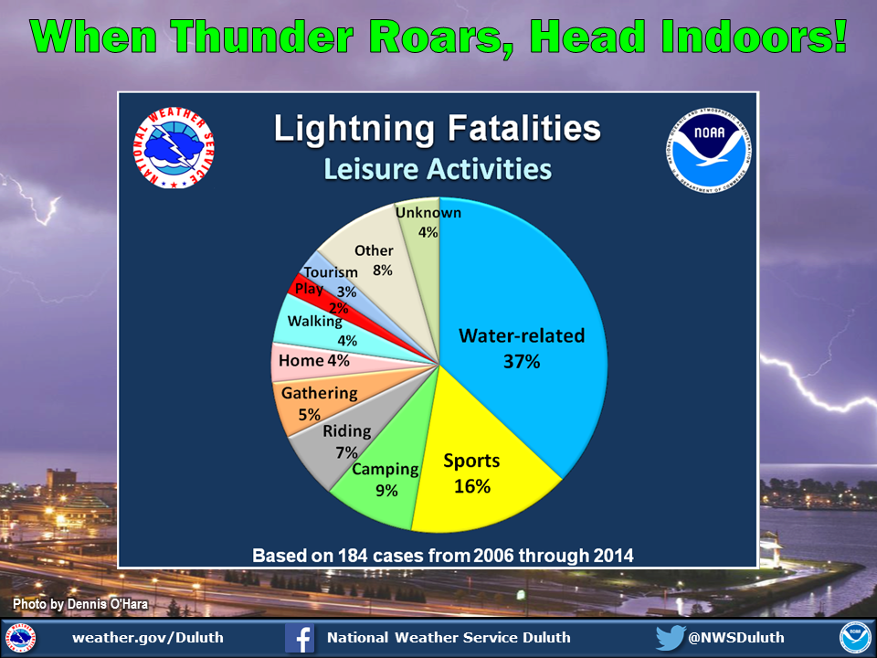
Lightning Safety Awareness Week Continues
"64% of all lightning related deaths occur when people are having fun outside. The number one recreational activity that people are taking part in when they are struck by lightning is fishing. How can you stay safe? It's simple: when thunder roars, head indoors!weather.gov/lightning/ #LightningSafety"
See more from the National Weather Service Duluth, MN HERE:
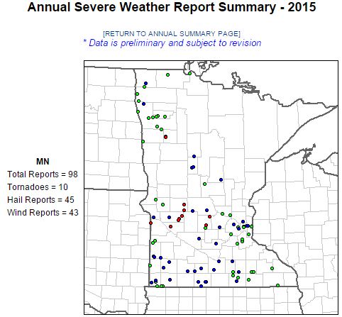
2015 Severe Storm Reports
According to NOAA's SPC, there have been 98 severe storm reports so far this year in Minnesota, 10
of which have been tornadoes.
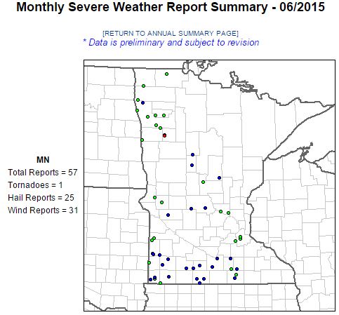
Severe Reports This June
According to NOAA's SPC, there have been 57 severe weather reports across the state of Minnesota this month, one of which was a tornado that occurred at 2:26am Monday, June 22nd.
PUBLIC INFORMATION STATEMENT NATIONAL WEATHER SERVICE GRAND FORKS ND 1258 PM CDT MON JUN 22 2015...
PRELIMINARY NWS DAMAGE SURVEY FOR MAHNOMEN COUNTY TORNADO EVENT...
RATING: EF-1 ESTIMATED PEAK WIND: 90-95 MPH
PATH LENGTH /STATUTE/: 400 YARDS
PATH WIDTH /MAXIMUM/: 30 YARDS
START DATE: 06/22/2015
START TIME: 226 AM CDT (ESTIMATED)
SURVEY SUMMARY: VERY PRELIMINARY RESULTS FROM THE NWS DAMAGE ASSESSMENT INDICATED A BRIEF TORNADO OCCURRED NEAR THE SHOOTING STAR CASINO IN MAHNOMEN...MINNESOTA.
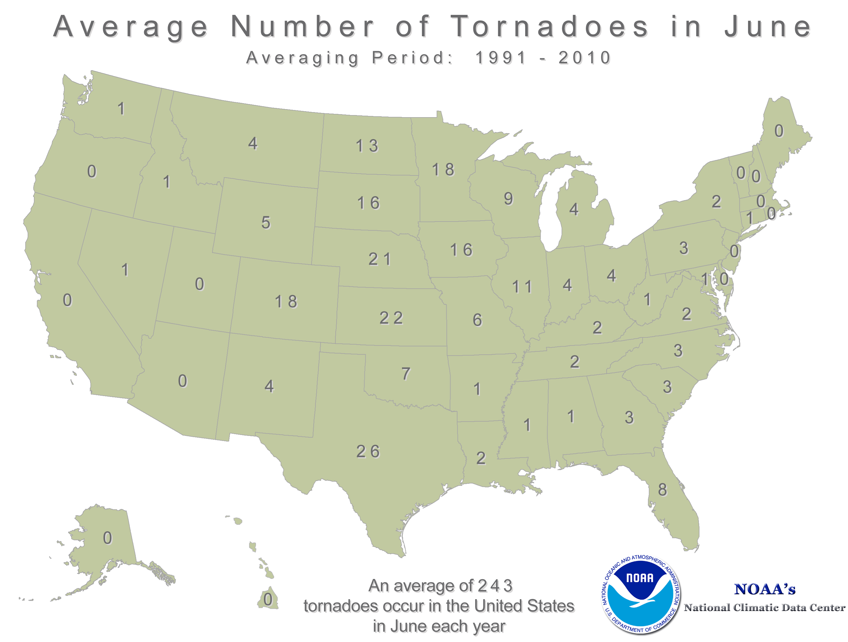
Average June Tornadoes
According to NOAA's NCDC, the average number of tornadoes in the state of Minnesota is greatest during the month of June with an average of 18 (Average: 1991-2010).
______________________________________________
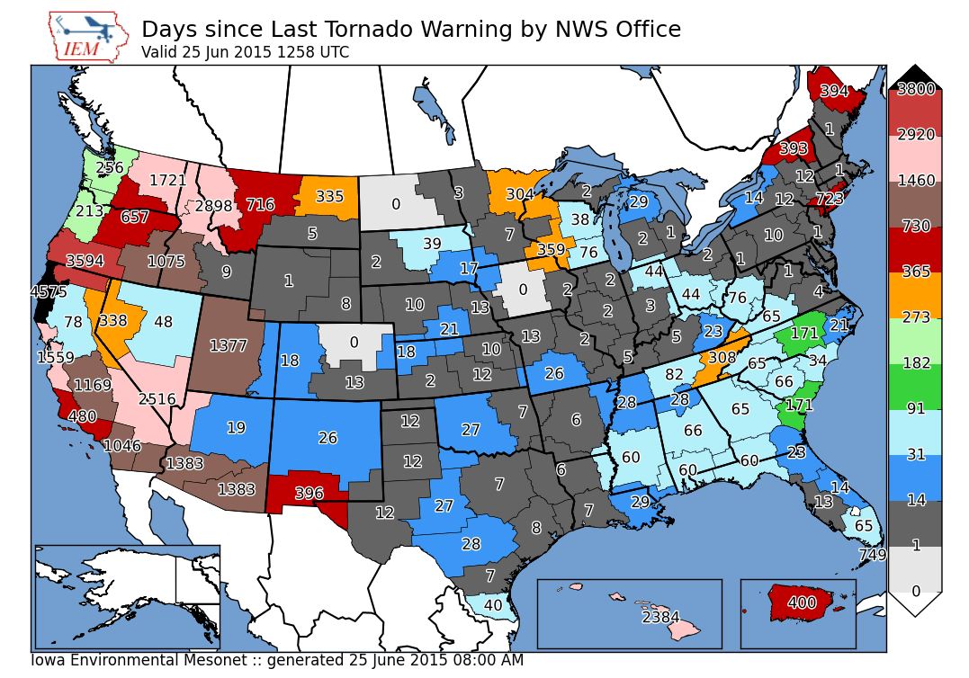
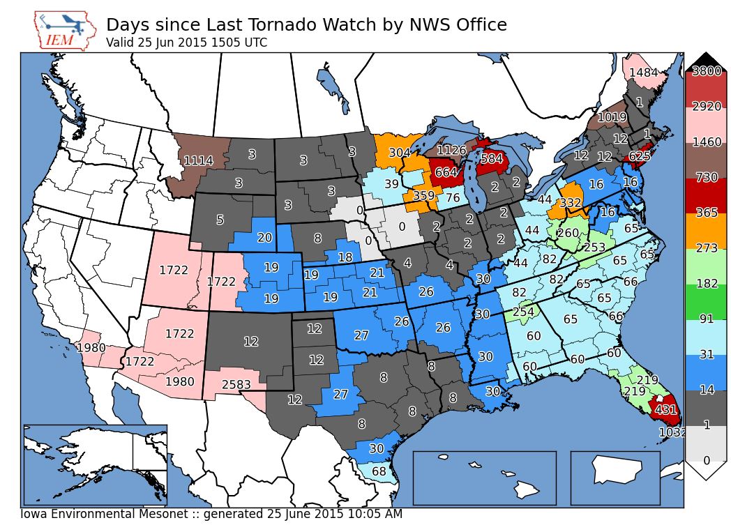
Days Since Last Tornado Warning/Watch
The images below from Iowa Environmental Mesonet show the last time tornado watches and warnings were issued for any specific National Weather Service county warning area.
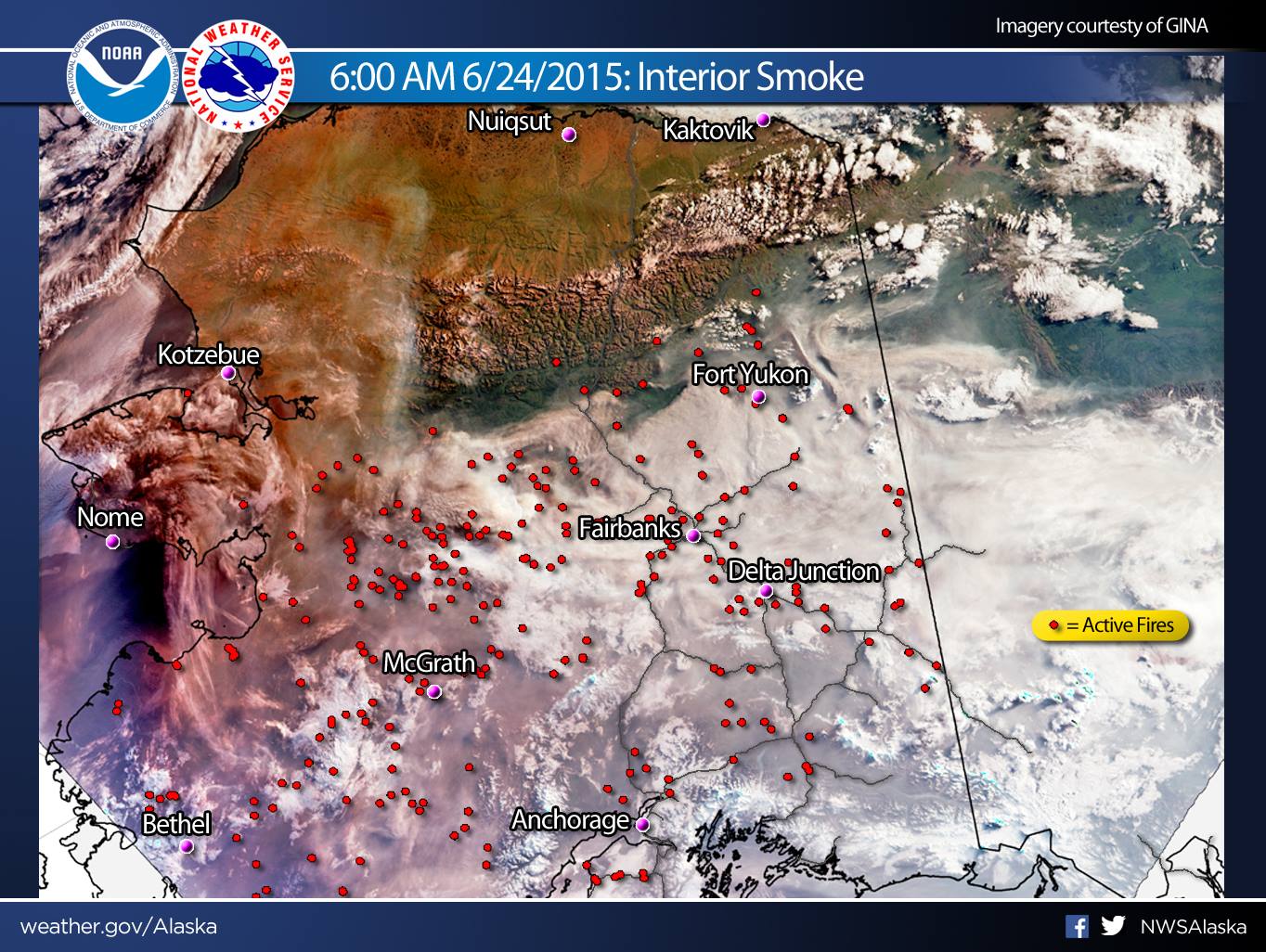
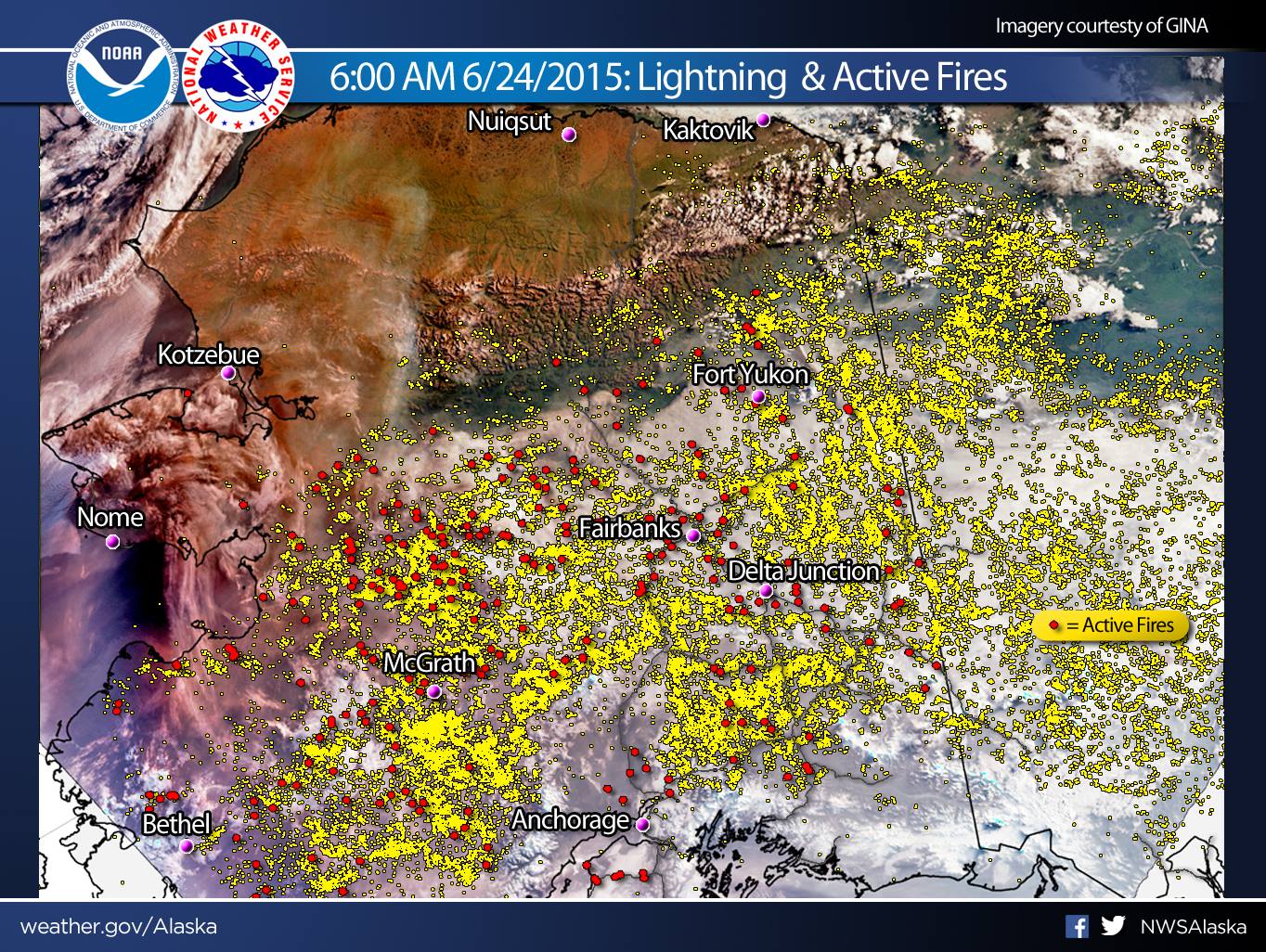
Alaska Wildfires Continue
Here's the latest information about the Alaskan wildfires from the National Weather Service out of Alaska
"Alaska continues to burn and smoke fills the skies. The first image was obtained from the VIIRS Polar Orbiter this morning. Each individual red circle is an active fire as denoted by the Alaska Interagency Coordination Center as of 6/24/2015. The opaque sky can be seen from Bristol Bay to the Brooks Range and well east into Canada. The second image overlays lightning data since 6/18/2015. There have been over 71,000 strikes that have occurred across the region since that time, though many are in Canada. One big caveat with the depiction of lightning imagery is that a recent change to sensors across the region means that we cannot make a direct one to one comparison with previous years. Regardless, lightning activity has been high. #akwx"
Keep abreast of the latest information at the following links:
Weather: weather.gov/Alaska
Fire: http://fire.ak.blm.gov/
DEC and Air Quality: www.facebook.com/AlaskaDEC
 |
|____________________________
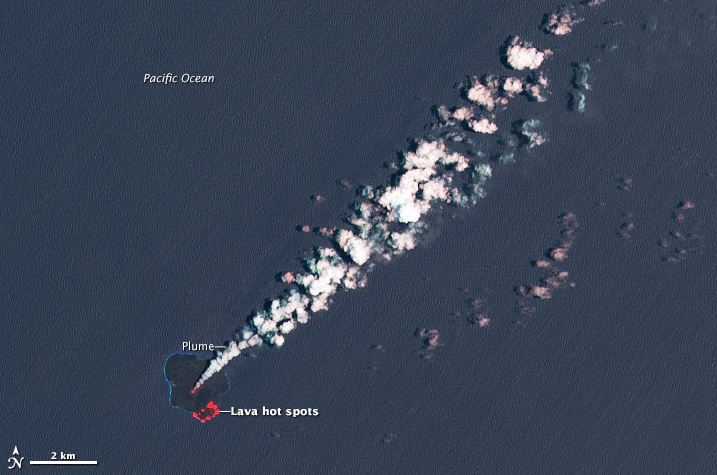
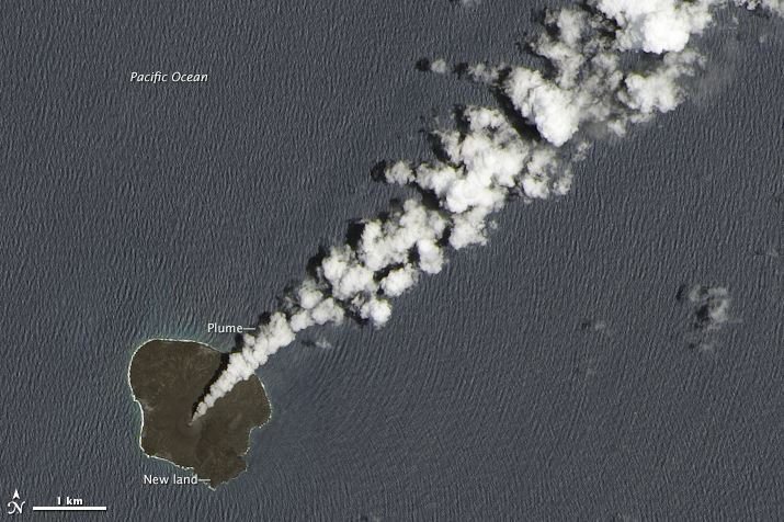
Growing Island in the Pacific Ocean
WOW! Here's a cool story from NASA's Earth Observatory about a tiny new island in the Pacific Ocean that continues to grow!
Volcanic activity along the western edge of the Pacific “Ring of Fire” gave rise to a tiny island in late November 2013. Since then, the new island has fused with nearby Nishinoshima and continued to grow. The plume of steam and sulfur dioxide drifting northeast appears white. Sea water is navy blue, and hot spots of lava are red. The lava is flowing toward the southeast part of the island but through tubes that prevent OLI from detecting it until it emerges in a lava delta at the edge of the island
See more HERE:
Thanks for checking in and have a great rest of your week and weekend ahead! Don't forget to follow me on Twitter @TNelsonWX

No comments:
Post a Comment