This is what northern lights look like from the International Space Station!! WOW!!
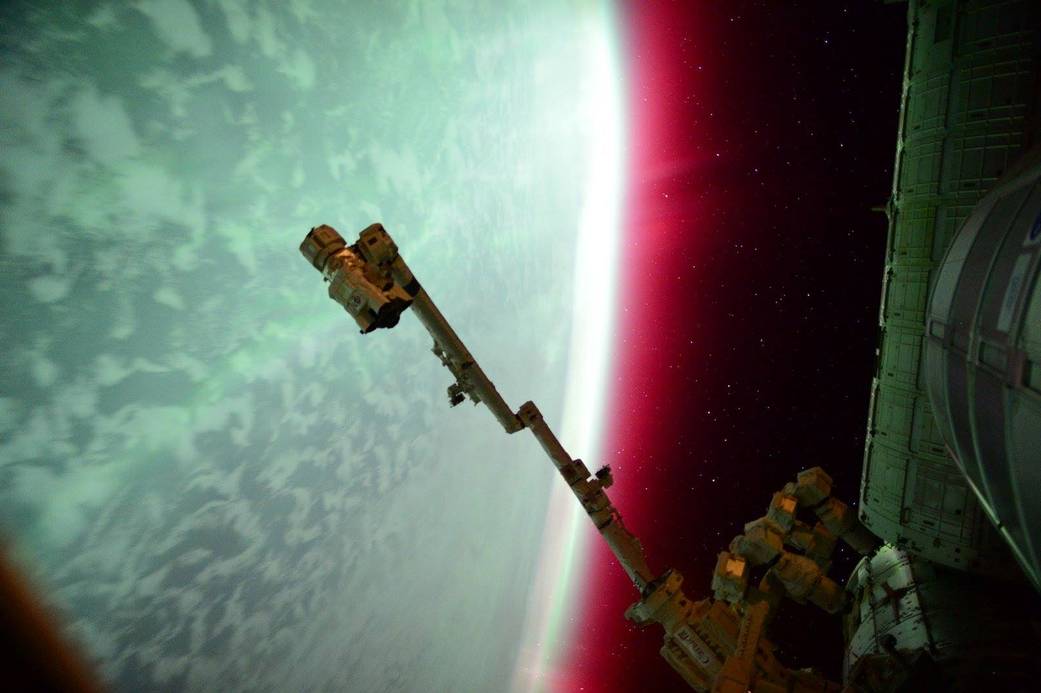
"NASA Astronaut Scott Kelly captured this photo of an aurora from the International Space Station on June 23, 2015. The dancing lights of the aurora provide spectacular views on the ground, but also capture the imagination of scientists who study incoming energy and particles from the sun. Aurora are one effect of such energetic particles, which can speed out from the sun both in a steady stream called the solar wind and due to giant eruptions known as coronal mass ejections or CMEs."
See more from NASA HERE:
(Image Credit: NASA)
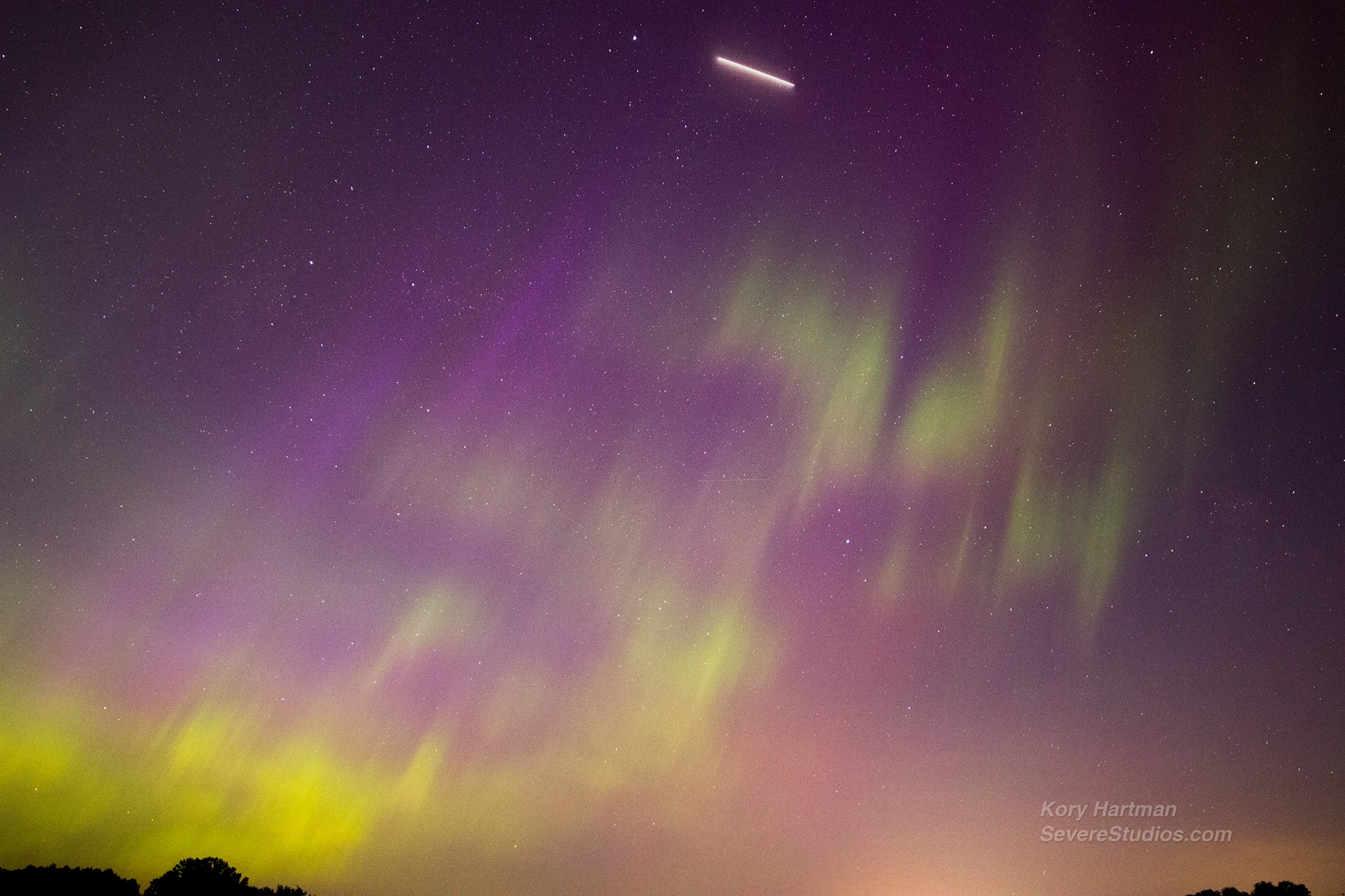
Thanks to my good friend and colleague for the picture (below) taken earlier this week near Hugo, MN. Not only did Kory Hartman (SevereStudios.com) capture the brilliant northern lights display, but he caught a space craft as well!
"AVUM (Attitude Vernier Upper Module) Stage" of a Vega rocket carrying the Sentinel-2A satellite. Launched from Kourou, French Guyana.
Read more about the Vega rocket HERE:
MORE Northern Lights Possible!!
Here's the latest from NOAA's Space Weather Prediction Center:
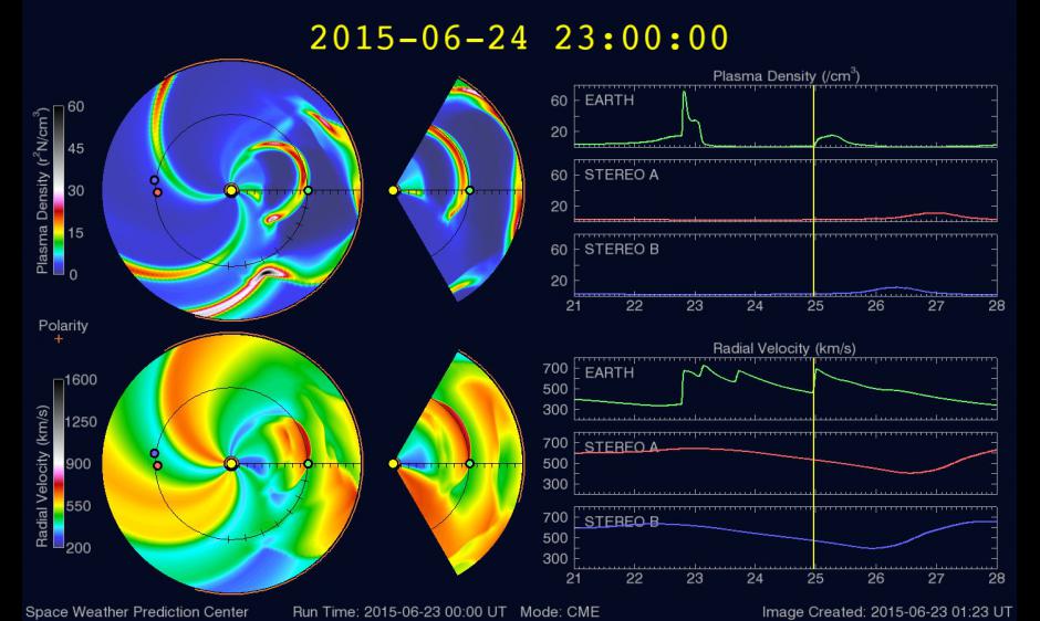
The coronal mass ejection that erupted June 22 in conjunction with the R2 solar flare has been modeled and arrival is expected June 24 at 2300 UT (7 pm EDT). This timing bodes well for aurora watchers in North America. As for the expected intensity, SWPC is continuing to analyze the event and will update the forecast when this analysis is complete.
See more from NOAA's SWPC HERE:
Here's another great northern lights monitoring site: SoftServeNews.com
__________________________________________
Lightning Safety
By Todd Nelson
Thunder could quite possibly be one of my favorite sounds ever! A long low rumble when you're trying to sleep or a loud crack to let you know that Mother Nature is in charge, I like them all! Whether or not you like the sound, you should respect it.
According to NOAA, 49 people die from lightning each year in the United States. So far this year, 9 people have died while outdoors during a thunderstorm. The National Weather Service states that NO PLACE outside during a thunderstorm is safe. If you hear thunder, lightning is close enough to strike you. Simple rule of thumb, "When thunder roars, go indoors." and wait at least 30 minutes until after the last rumble of thunder to go back outside.
Weather conditions for us remain 'mostly' quiet over the next few days with just a few spotty thunderstorm chances during the afternoon and evening hours. Rainfall potential over the next 3 to 5 days remains quite low across much of the region as the main storm track settles farther south.
NOAA's Climate Prediction Center released a July, August, September temperature outlook, which suggests near or slightly below average temps over the next 3 months. -Todd Nelson
________________________________
WEDNESDAY NIGHT: Slight chance of a passing thundershower. Low: 64. Winds: S 5.
THURSDAY: Spotty afternoon rumbles. High: 80. Winds: NNE 5-10.
THURSDAY NIGHT: Partly cloudy and quiet. Low: 62.
FRIDAY: Isolated PM T-shower possible, mainly southern MN. Wake-up: 62. High: 78
SATURDAY: Mostly dry. Puffy afternoon clouds. Wake-up: 60. High: 81
SUNDAY: Scattered PM storms. Wake-up: 62. High: 80.
MONDAY: Sun returns, still mild and a little more humid. Wake-up: 64. High: 82.
TUESDAY: Warmer, slight chance of thunder. Wake-up: 64. High: 87.
WEDNESDAY:
________________________
________________________
This Day in Weather History
June 25th
2003:
Heavy rains across central Minnesota. Elk River picked up 8.19 inches.
4.36 inches in 4 hours in Maplewood with reports of street flooding in
St. Paul. Strong winds toppled trees in Richfield.June 25th
1950: Flood at Warroad. Strong winds accompanied waters that rose 4 feet in 10 minutes.
_________________________________
Average High/Low for Minneapolis
June 25th
Average High: 82F (Record: 98F set in 1934)
Average Low: 62F (Record: 46 set in 1972)
__________________________________
Sunrise/Sunset Times for Minneapolis
June 25th
Sunrise: 5:28am
Sunset: 9:03pm
__________________________________
Moon Phase for June 25th at Midnight
1.8 Days Since First Quarter
__________________________________
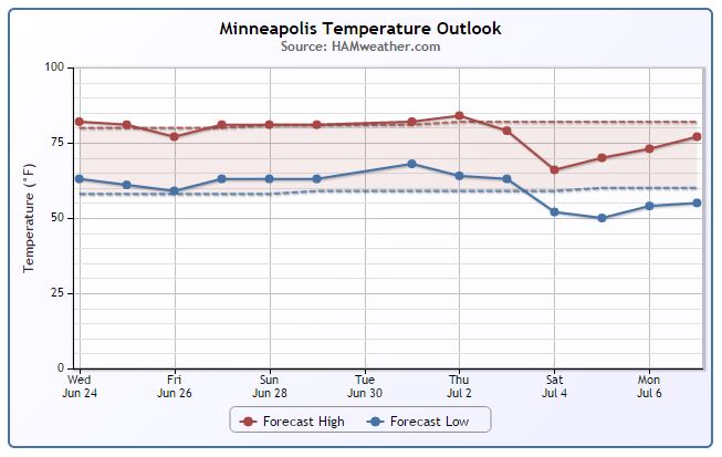
Minneapolis Temperature Trend
Mild and near average temperatures look to continue over the next several days. Looking at the extended forecast towards the 4th of July weekend, there may be a bit of a cool down by then, but it's too early to bet the farm.
__________________________________
Thursday Weather Outlook
Thursday won't be a bad day either as most of us stay dry with highs near average and light winds. There may be a late day rumble of thunder again, but it won't be a washout.
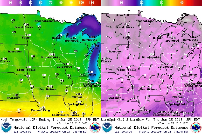
Thursday Weather Outlook
Partly sunny skies with a few afternoon rumbles of thunder is all that is expected for Thursday. Most of the active/severe weather will be found farther south again today.
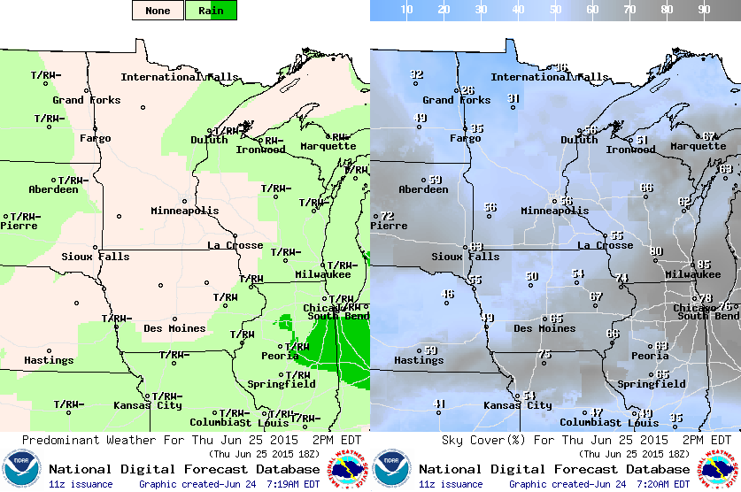
Rainfall Potential
We should still be void of any significant rainfall potential through the end of the week/early weekend. There's a chance of a pocket of heavy rain or two where some of the isolated afternoon/evening thundershowers develop, but nothing will be widespread.
_______________________________________
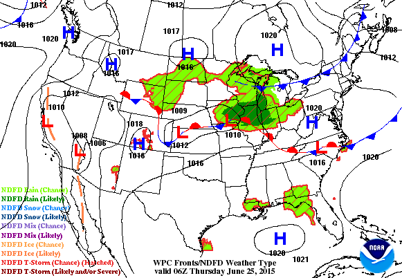
National Weather Outlook
An impulse of energy working through the mid-section of the nation Wednesday and Thursday will help to pull down cooler air from Canada and set up over the Great Lakes Region/Ohio Valley by the weekend. This will actually help to push the heavier rain and severe weather threat a little farther south as well. In the meantime, areas in the Upper Mississippi Valley may see a few spotty afternoon/evening thundershowers, but nothing major.
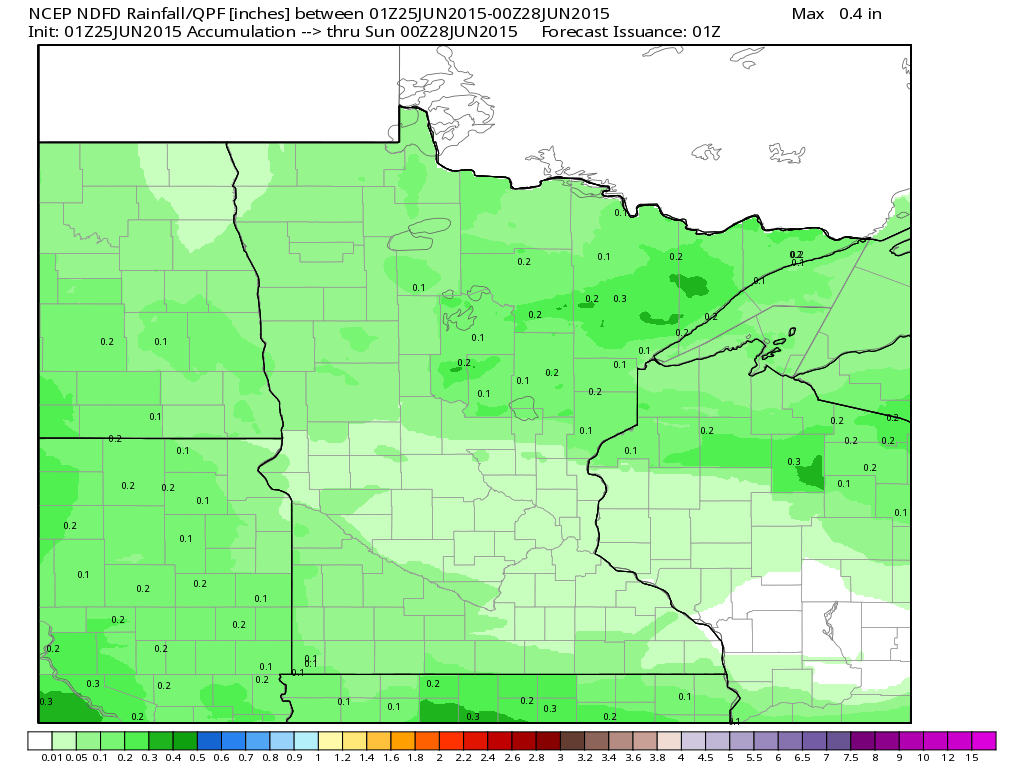
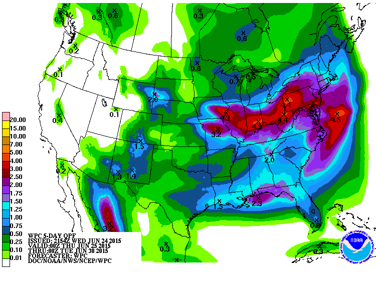
5 Day Precipitation Outlook
According to NOAA's HPC, the 5 day rainfall potential keep much of the heavy moisture 1" to 3"+ across parts of the Ohio/Tennessee Valley and Mid-Atlantic Region through early next week. Note the Western U.S. looks to remain mostly dry.
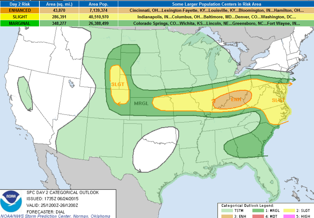
Severe Threat Thursday
...SUMMARY... STRONG TO SEVERE THUNDERSTORMS WITH POTENTIAL FOR DAMAGING WIND GUSTS AND HAIL WILL BE POSSIBLE THURSDAY AFTERNOON FROM THE CENTRAL PLAINS EAST INTO THE OHIO VALLEY AND MIDDLE ATLANTIC AREA. A SEVERE THREAT IS ALSO EXPECTED LATE THURSDAY AFTERNOON ACROSS PARTS OF THE CENTRAL HIGH PLAINS WHERE LARGE HAIL AND ISOLATED DAMAGING WIND GUSTS MAY OCCUR. ...OH VALLEY REGION... BY 12Z THURSDAY A WARM FRONT SHOULD EXTEND FROM NC NWWD TO A WEAK SFC LOW OVER THE MIDDLE MISSOURI RIVER VALLEY AREA. A COLD FRONT WILL EXTEND SWWD FROM THE LOW INTO THE CNTRL PLAINS. IT IS LIKELY THAT THUNDERSTORMS WILL BE ONGOING WITHIN ZONE OF ISENTROPIC ASCENT NORTH OF THE WARM FRONT FROM NRN IL THROUGH NRN OH EARLY THURSDAY. THIS ACTIVITY IS EXPECTED TO SHIFT ESEWD DURING THE MORNING HOURS. A MOIST WARM SECTOR WITH NEAR 70F DEWPOINTS WILL ADVECT ENEWD THROUGH THE OH VALLEY IN WAKE OF EWD MOVING WARM FRONT. DIABATIC WARMING OF THE MOISTENING BOUNDARY LAYER WILL RESULT IN MODERATE INSTABILITY WITH 1500-2000 J/KG MLCAPE LIKELY. CURRENT INDICATIONS ARE THAT THE SHORTWAVE TROUGH NOW MOVING INTO ND WILL CONTINUE ESEWD INTO THE GREAT LAKES AND NRN PORTION OF THE OH VALLEY IN ADDITION TO A POSSIBLE MCV ASSOCIATED WITH EARLY CONVECTION. STORMS ARE EXPECTED TO REDEVELOP ALONG AND SOUTH OF A COLD FRONT AND POSSIBLY ALONG RESIDUAL OUTFLOW BOUNDARIES THAT WILL PUSH SWD THROUGH THIS REGION DURING THE AFTERNOON. A BELT OF STRONGER WINDS ALOFT ACCOMPANYING THE SHORTWAVE TROUGH EMBEDDED WITHIN NWLY FLOW WILL SUPPORT 40+ KT EFFECTIVE SHEAR. SUPERCELLS MAY BE THE INITIAL THREAT AS STORMS REDEVELOP...BUT TENDENCY MAY BE FOR SOME OF THE STORMS TO GROW UPSCALE INTO LINE/BOWING SEGMENTS. LARGE HAIL AND DAMAGING WIND WILL BE THE MAIN THREATS...BUT A FEW TORNADOES WILL BE POSSIBLE ESPECIALLY IN VICINITY OF THE WARM FRONT FROM OH INTO WV. ...MID ATLANTIC AREA... A MOIST WARM SECTOR WILL RETURN NWD THROUGH THIS AREA IN WAKE OF NWD ADVANCING WARM FRONT. WIDELY SCATTERED THUNDERSTORMS ARE EXPECTED TO DEVELOP AS THE BOUNDARY LAYER DESTABILIZES. THIS REGION WILL RESIDE WITHIN BELT OF MODERATE-STRONG FLOW ALOFT SUPPORTING A THREAT FOR SUPERCELLS WITH LARGE HAIL AND DAMAGING WIND. A FEW TORNADOES WILL ALSO BE POSSIBLE ESPECIALLY IN VICINITY OF THE WARM FRONT ACROSS A PORTION OF VA/MD WHERE LARGER HODOGRAPHS WILL EXIST. ...CNTRL HIGH PLAINS... NORTHWESTERLY MID-LEVEL FLOW WILL BE IN PLACE ACROSS THE NCNTRL STATES AS AN UPPER-LEVEL RIDGE BUILDS ACROSS THE PACIFIC NORTHWEST. AT THE SFC...A COLD FRONT IS FORECAST TO MOVE SWD ACROSS THE CNTRL PLAINS AS AN UPSLOPE FLOW REGIME DEVELOPS ACROSS THE HIGH PLAINS. AN AXIS OF MODERATE INSTABILITY IS FORECAST BY AFTERNOON FROM ERN CO NWD INTO ERN WY AND WRN NEB. THUNDERSTORMS SHOULD INITIATE IN THE HIGHER TERRAIN AND MOVE EWD INTO THE LOWER ELEVATIONS OF THE CNTRL HIGH PLAINS BY LATE AFTERNOON. FORECAST SOUNDINGS NEAR SCOTTSBLUFF NEB AT 00Z/FRIDAY SHOW MLCAPE NEAR 2000 J/KG WITH 0-6 KM SHEAR OF 45-50 KT AND STEEP 850 TO 500 MB LAPSE RATES. THIS ENVIRONMENT SHOULD SUPPORT A SUPERCELL THREAT AS CELLS INCREASE IN COVERAGE DURING THE LATE AFTERNOON. SUPERCELLS SHOULD BE CAPABLE OF PRODUCING LARGE HAIL AND ISOLATED WIND DAMAGE. THE WIND DAMAGE THREAT MAY BECOME GREATER DURING THE EARLY EVENING AS CELL COVERAGE INCREASES AND DOWNDRAFTS BECOME MORE MATURE.
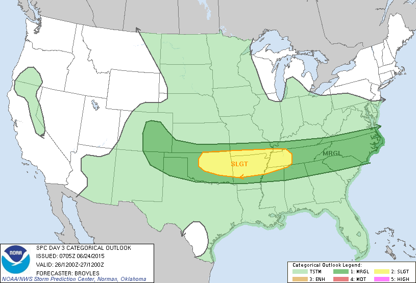
Severe Threat Friday
...SUMMARY... STRONG TO SEVERE THUNDERSTORMS WILL BE POSSIBLE ACROSS THE SOUTHERN PLAINS...SOUTHERN OZARK MOUNTAINS...OUACHITA MOUNTAINS AND WESTERN PARTS OF THE TENNESSEE VALLEY. ...OZARKS/OUCHITAS/SRN AND CNTRL PLAINS/WRN TN VALLEY... AN UPPER-LEVEL TROUGH IS FORECAST TO MOVE SEWD ACROSS THE CNTRL PLAINS ON FRIDAY AS A COLD FRONT ADVANCES SWD ACROSS THE SRN PLAINS...SRN OZARKS AND TN VALLEY. AS SFC HEATING TAKES PLACE AND LOW-LEVEL CONVERGENCE INCREASES ALONG THE BOUNDARY...THUNDERSTORMS SHOULD INITIATE AND MOVE ESEWD INTO MODERATE TO STRONG INSTABILITY. SEVERAL THUNDERSTORM CLUSTERS COULD ORGANIZE ACROSS THE REGION FROM MID AFTERNOON INTO EARLY EVENING. NAM FORECAST SOUNDINGS AT 21Z FROM ERN OK EWD INTO WRN TN SHOW SFC DEWPOINTS IN THE LOWER 70S F...MLCAPE OF 2000 TO 3000 J/KG AND 0-6 K SHEAR OF 25 TO 30 KT. THIS SHOULD SUPPORT SEVERE THUNDERSTORM DEVELOPMENT AS MULTICELLS INCREASE IN COVERAGE DURING THE LATE AFTERNOON. ALTHOUGH DEEP-LAYER SHEAR MAY BE A BIT WEAK FOR SUPERCELLS...THE ENVIRONMENT SHOULD STILL SUPPORT ORGANIZED MULTICELL LINE SEGMENTS WITH WIND DAMAGE POTENTIAL. THE DEVELOPMENT OF A COLD POOL WITH A LOCALLY GREATER WIND DAMAGE THREAT SEEMS POSSIBLE IN AREAS WHERE THE AIRMASS DESTABILIZES THE MOST. A MARGINAL SEVERE THREAT COULD ALSO DEVELOP FRIDAY AFTERNOON FROM ERN CO SEWD INTO THE TX PANHANDLE WHERE CONVECTION SHOULD BE ISOLATED BUT INSTABILITY AND SHEAR SHOULD BE SUFFICIENT FOR STRONG UPDRAFTS. ...SRN APPALACHIANS/CAROLINAS... A COLD FRONT IS FORECAST TO MOVE SWD ACROSS THE SRN APPALACHIANS AND NORTH CAROLINA FRIDAY AFTERNOON. THUNDERSTORM DEVELOPMENT WILL BE POSSIBLE ALONG THE FRONT AS SFC TEMPS WARM AND LOW-LEVEL CONVERGENCE INCREASES. SFC DEWPOINTS IN THE 60S F ACROSS THE SRN APPALACHIANS AND IN THE LOWER 70S F IN THE CAROLINAS SHOULD RESULT IN MODERATE INSTABILITY BY AFTERNOON. ALTHOUGH MID-LEVEL LAPSE RATES ARE FORECAST TO BE POOR ALONG THIS CORRIDOR...ENOUGH DEEP-LAYER SHEAR SHOULD BE PRESENT FOR A MARGINAL WIND DAMAGE THREAT NEAR OR JUST AFTER PEAK HEATING.
____________________________________________
Lightning Safety Awareness Week (June 21-27)
"Lightning strikes the United States about 25 million times a year. Although most lightning occurs in the summer, people can be struck at any time of year. Lightning kills an average of 49 people in the United States each year, and hundreds more are severely injured."
The information below is from NOAA's Lightning Saftey Page HERE:
Lightning: What You Need to Know
NO PLACE outside is safe when thunderstorms are in the area!!
If you hear thunder, lightning is close enough to strike you.
When you hear thunder, immediately move to safe shelter: a substantial building with electricity or plumbing or an enclosed, metal-topped vehicle with windows up.
Stay in safe shelter at least 30 minutes after you hear the last sound of thunder.
Indoor Lightning Safety
Stay off corded phones, computers and other electrical equipment that put you in direct contact with electricity.
Avoid plumbing, including sinks, baths and faucets.
Stay away from windows and doors, and stay off porches.
Do not lie on concrete floors, and do not lean against concrete walls.
Last Resort Outdoor Risk Reduction Tips
If you are caught outside with no safe shelter anywhere nearby the following actions may reduce your risk:
Immediately get off elevated areas such as hills, mountain ridges or peaks
Never lie flat on the ground
Never shelter under an isolated tree
Never use a cliff or rocky overhang for shelter
Immediately get out and away from ponds, lakes and other bodies of water
Stay away from objects that conduct electricity (barbed wire fences, power lines, windmills, etc.)
==========================
Here are some lightning facts from KidsDiscover.com
1.) How hot is a lightning bolt? Only about 54,000 degrees Fahrenheit — roughly five times hotter than the surface of the sun!
2.) Lightning flashes more than 3 million times a day worldwide — that’s about 40 times a second. Not all those flashes hit the ground — some happen between or inside clouds.
3.) An average lightning bolt can release enough energy to operate a 100-watt light bulb for more than three months straight (about 250 kilowatt-hours of energy).
4.) Lightning starts in cumulonimbus clouds — aka thunderheads — which have a positive charge up top and a negative charge below. We don’t know how the charges start, but water droplets and ice crystals carry them.
5.) That negative charge in the cloud creates a positive charge on Earth below, and the two charges start trying to connect and create a circuit. Ever seen electrical sparks jump across a space? It’s like that, but way bigger.
6.) The air between the clouds and Earth blocks the connection — until the charge gets so strong that an electrical impulse called a “stepped leader” shoots down from the cloud.
7.) The leader drops in steps of about 150 feet each at about 136,000 mph, until it almost reaches the ground. That’s when an electrical charge called a streamer rises up to meet it and complete the circuit.
Then a bolt of electricity streaks back up along the leader’s path at about 62 million mph and creates lightning. More bolts can rise up the same path again right after. Because it all happens so fast, all we see is one bolt of lightning.
8.) All that energy travels along a path about as wide as a thumb!
9.) The streamer can travel up through a building, a tree, or even a person, which can be fatal.
10.) Lightning kills about 2,000 people globally per year, so stay inside during lightning storms.
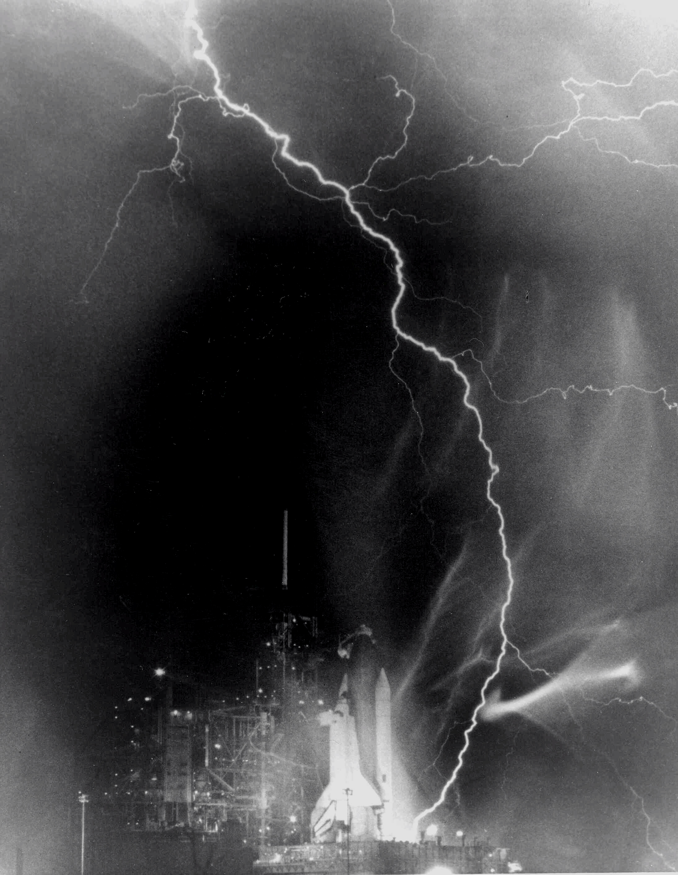
(Image courtesy: NASA)
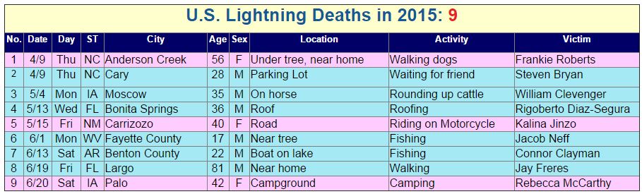
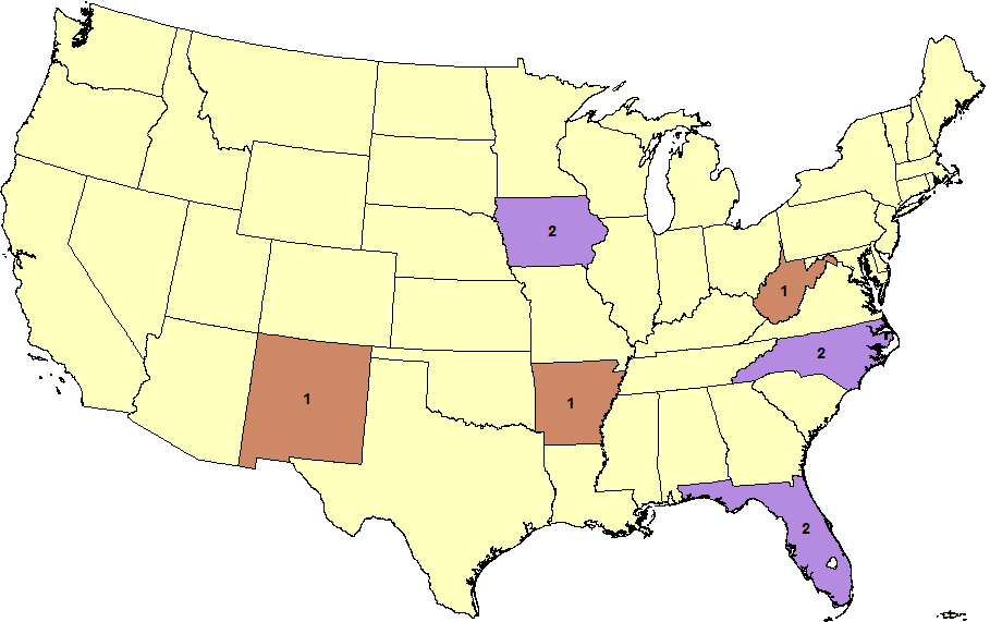
2015 Lightning Fatalities
On Saturday, June 20th a 42 year old woman died after being struck by lightning in Palo, IA while camping. That brings the 2015 lightning fatality number to now 9! 2 people have now died in the states of Iowa, North Carolina and Florida. According to NOAA the 30-year average (1985-2014) of lightning deaths is 49.
See more from NOAA HERE:
____________________________________________
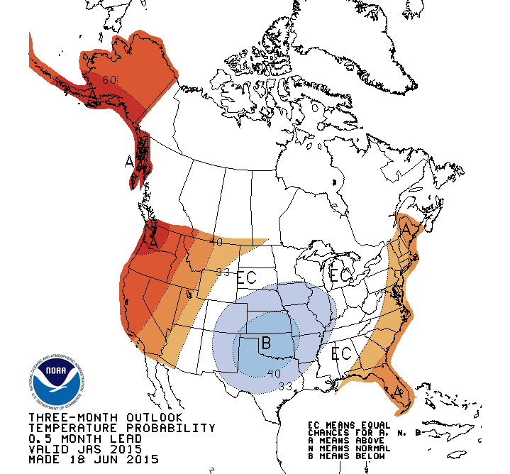
Temperature Outlook for Summer
According to NOAA's Climate Prediction Center, there's a slightly better chance of cooler than average temperatures for the Central U.S. over the next 3 months (July, August and September). Meanwhile, folks on the East Coast, in the Western U.S. and Alaska could see warmer than average conditions.
________________________________
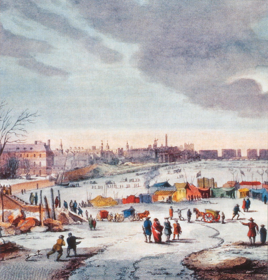
"Return of 'grand solar minimum' could affect European and eastern US winters"
Here's an interesting read from the UK Met Office that just published an article regarding the potential return of a 'grand solar minimum, something that hasn't been seen in nearly 300 years during the 'Maunder Minimum' when the Thames River in England froze.
"A return to low solar activity not seen for centuries could increase the chances of cold winters in Europe and eastern parts of the United States but wouldn't halt global warming, according to new research. The Met Office-led study, published in Nature Communications, is among the first to look at the regional climate impacts of a possible 'grand solar minimum'. It's understood the sun's output increases and decreases, measured by the number of sunspots on the star's surface, over a timescale of 100 - 200 years. Some solar physicists believe there's an increased risk that we're heading towards the lower end of this cycle - last seen during the so-called 'Maunder Minimum' which ended 300 years ago. This coincided with colder winters in the UK and Europe, with 'frost fairs' held numerous times on a frozen River Thames."
See more from the UK Met Office HERE:
See more about the River Thames Frost Fairs HERE:
(Thames Frost Fair, 1683-84, by Thomas Wyke via wikipedia - image: public domain)
Thanks for checking in and have a great rest of your week! Don't forget to follow me on Twitter @TNelsonWX

No comments:
Post a Comment