TODAY: Sunny and spectacular with lower humidity. Dew Point: 57. Winds: West 8-13. High: 84
SUNDAY NIGHT: Clear and comfortable. Low: 64
MONDAY: Patchy clouds, few T-showers south. High: 82
TUESDAY: Blue sky, still quiet. Wake-up: 63. High: 83
WEDNESDAY: Partly sunny, seasonably warm. Wake-up: 65. High: 84
THURSDAY: Sticky sun. Dew Point: 63. Wake-up: 69. High: 85
FRIDAY: Few showers and T-storms. Wake-up: 68. High: 83
SATURDAY: Warm, hazy sun. Lake-worthy. Wake-up: 70. High: 89
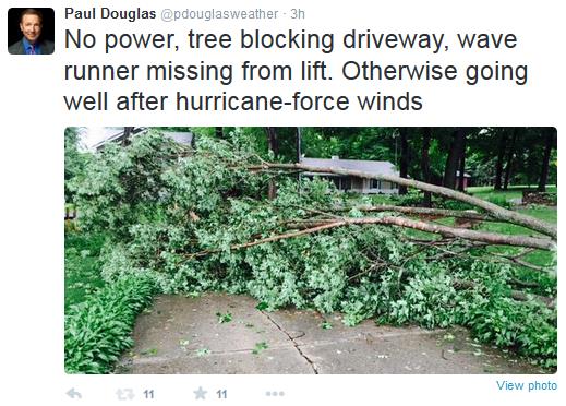
PowerlessThe
first thing I noticed was the utter silence. Total quiet - no
background hum of TV or radio. The only tweets came from birds - the
lapping of lake water and jets droning overhead. The power was out, for
the second time in 5 days. We were at our cabin near Nisswa when
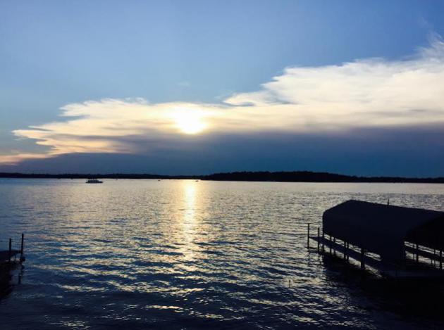
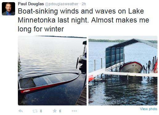
Sunday night's downburst flattened trees. We were home, near Excelsior, when
Friday night's maelstrom swept across 'Tonka with hurricane force gusts that blew for the better part of 20 minutes.
Saturday
I got to go on a scavenger hunt. "Have you see the waverunner?" Nope.
But Minnesotans chip in and help without hesitation. A neighbor
chainsawed his way through the tree blocking our driveway. Another found
our wayward water toy and dragged it back to our battered dock. First
world problems perhaps, but I'm continually amazed at how bad moments
bring out the best in us.
Today looks stunningly nice: less drama,
running, screaming - no tumbling trees, just bright sun and low 80s as
the dew point drops into the 50s. Fresh air.
We warm to near 90F by the end of this week; a mostly-dry sky into at least
Friday. Good thing: 5.5 inches of rain so far in July, twice the normal amount, to date. No drought this year!
*
Like so many other Minnesotans we are without power as of midday
Sunday. I drove into the office to update the blog and file Monday's
column, so pardon the relative brevity. We're all doing the best we can
under the circumstances. Enjoy the rest of your weekend, with or without
power!
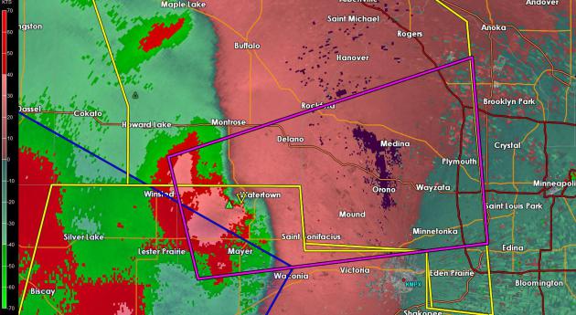
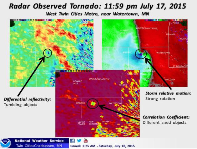
EF-1 Tornado Damage In Watertown. The Star Tribune has more information, including
video coverage, of the freak EF-1 tornado that was on the ground for about 4 miles around midnight Friday night.
Evidence of Severe Rotation.
SRV or Storn Relative Velocity at 12:07 AM picked up evidence of
rotation strong enough to support a tornado circulation extending to the
ground around midnight. NWS Doppler courtesy of the Twin Cities office
loated in Chanhassen.
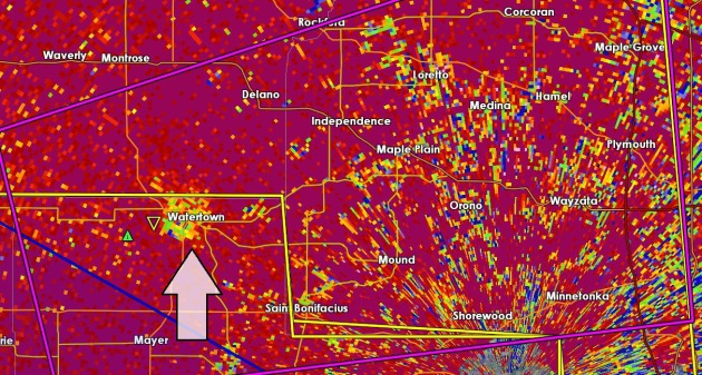
Doppler Dual-Pol Correlation Coefficient Detecting Tornado Debris In The Air?
The number went up to .80 around midnight over Watertown at about 12:09
AM Saturday, suggesting debris lofted into the air from a potential
tornado strike. It's consistent with strong rotation detected in the
image above, using Storm Relative Velocity (SRV).
Strong Forensic Evidence of Tornado On The Ground.
Whatever hit the Watertown area around midnight was kicking up debris,
and there was a strong "couplet" on the radial velocity Doppler display.
I'll be surprised if it wasn't a tornado. Stating the obvious:
confirmation of a tornado becomes very difficult at night, even with the
nearly continuous lightning display we had last night. The storm may
have been rain-wrapped, making it very difficult to see.
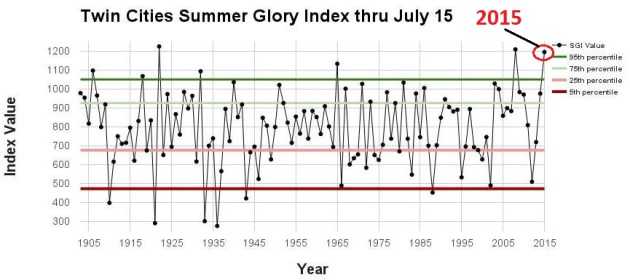
First Half of Summer in the Twin Cities: 3rd Most Glorious Since 1903
In the winter we torment you with the WMI, the Winter Misery Index. So
the summer has a comparable index, based on temperature, dew point,
precipitation ranges and lack of crazy extremes.
The Minnesota DNR
and Minnesota Climate Office has put together their "Summer Glory
Index" or SGI, and your hunch is correct: so far this has been a
much-above average summer. Here's an excerpt: "...
The all-new Summer
Glory Index (SGI) can help us answer these questions. Any day from June
through August can earn up to 40 Glory points for being within “ideal”
temperature, dew point, and precipitation ranges, and can lose points
for being too hot, cold, wet, or humid. A given year’s SGI is then the
sum of all the points earned and lost, and tells us how frequently we’ve
experienced glorious conditions....Through July 15, this summer has
been the third most glorious on record. Only 1922 and 2008 were better.
Our current high ranking should come as no surprise: to date,
Minneapolis has only topped 90 degrees once, has not recorded a minimum
temperature of 70 or greater, has only had one 6 PM dew point reading
above 70 degrees, and has had just two calendar days with over an inch
of rain..."
How The SGI (Summer Glory Index) Is Calculated. The Minnesota Climate Office
explains the logic behind the SGI and how the scores for each day are
tabulated. As much as I like a hot day at the lake I think most of us
can probably agree on what constitutes a glorious summer day. Here's an
excerpt: "...
The index is based on the notion that we like to sleep
through the night soundly without excessive energy consumption, and we
want to be able to get outside and stay outside during the day without
having our activities postponed or cancelled. Of course some like it
hot, some like it muggy, and some like it stormy, but very few people
enjoy rain-outs, blasting the AC all night, or wearing winter clothes to
the barbeque. The SGI, therefore, rewards days that are comfortable and
dry, and punishes days for being too hot, too cold, too humid, or too
wet. In the index, a perfectly glorious day has a high temperature of
73-79, a low of 57-64, a 6 PM dew point of less than 60, and no
measurable rain. Such a day earns 10 points for each category, or 40
points total..."
Highly Variable Rainfall in Minnesota First Half of July. Here's an excerpt from this week's edition of Mark Seeley's
WeatherTalk: "...
Rainfall
in July has been highly variable, but with some observers already
reporting above normal totals for the month. In the northwestern portion
of the state New Folden (Marshall County) has already received 6.33
inches; in the north-central part of the state Aitkin reports 5.24
inches; in central Minnesota Milaca reports 5.13 inches and Mora reports
5.26 inches; in southern Minnesota Farmington reports 5.85 inches and
Hastings 5.29 inches..."
ADVERTISEMENT
More
than 100mm of rain fell on the Norwegian village of Ogndal, an amount
rarely seen outside the tropical rainforests of Brazil or Indonesia. The
downpour, which left farm animals petrified and meteorologists
scratching their heads, is believed to have shattered records for the
area,
the Local has reported.
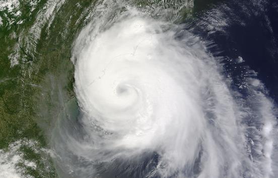
4 Reasons The Atlantic Hurricane Season Has Been So Quiet - And Is Likely To Stay That Way. Here's an excerpt from a good post at
The Capital Weather Gang: "...
The
lazy summer comes as no surprise to seasonal hurricane forecasters who
all predicted a relatively inactive season before it began June 1. NOAA’s forecast in late May called
for a 70 percent chance of a below-average season, with six to 11 named
storms, three to six of which could become hurricanes, and up to
two major hurricanes. It was the highest probability of a below-average
season that NOAA had ever forecast..."
Image credit above: "
The
first hurricane of the 2014 season made landfall in North Carolina. The
U.S. has had no such hurricane landfall this year, nor any hurricane
development in the Atlantic Ocean." (NASA).
Smartphone Usage Could Be Analyzed To Warn of Depression. Here's something of a head-scratcher, but maybe there's some merit to this. Details from
Gizmag; here's a clip: "
One
of the problems with depression is that because it often forms so
gradually, many people don't even realize that they're suffering from it
– they just assume that normal life is pretty dreary. With that in
mind, researchers from Chicago's Northwestern University have devised a
method of analyzing at-risk individuals' smartphone use, to see if
they're developing signs of the disorder..." (File photo: Shutterstock).
Climate Stories....
A Cheap But Dangerous Global Warming Fix. Paging
Dr. Evil. Dr. Evil, your Gulfstream 7 is ready with the chemicals you
requested. God help us if we ever get to this stage. Here's an excerpt
of an interview at the
PBS Newshour: "...
A
controversial, but cheap solution of last resort has emerged known as
“solar radiation management.” A geoengineering technique, it would shoot
particles into the sky to reflect sunlight back to space. “The central
idea is to make the planet a little bit more reflective, which tends to
cool it down, because it will absorb less sunlight. And that will
partially and imperfectly compensate for the buildup of greenhouse gases
like carbon dioxide, which are tending to trap heat and make the earth
warmer,” says Harvard environmental scientist David Keith, who works at
the intersection of environmental science, energy technology and public
policy..."
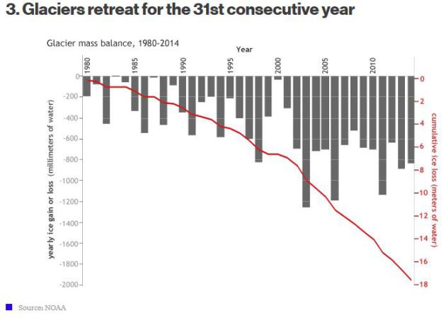
The Freakish Year In Broken Climate Records. It's
getting harder to ignore or refute the evidence. Forget the models,
just look at current conditions and trends worldwide. Here's an excerpt
from
Bloomberg Business: "
The annual State of the Climate report
is out, and it’s ugly. Record heat, record sea levels, more hot days
and fewer cool nights, surging cyclones, unprecedented pollution, and
rapidly diminishing glaciers. The U.S. National Oceanic and Atmospheric
Administration (NOAA) issues a report each year compiling the latest
data gathered by 413 scientists from around the world. It’s 288 pages,
but we’ll save you some time. Here’s a review, in six charts, of some of
the climate highlights from 2014..."
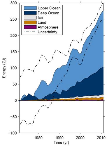
Warming of Oceans Due To Climate Change is Unstoppable, Say U.S. Scientists.
The Guardian has the article; here's a snippet: "...
Even
if we were to freeze greenhouse gases at current levels, the sea would
actually continue to warm for centuries and millennia, and as they
continue to warm and expand the sea levels will continue to rise,”
Johnson said. On the west coast of the US, freakishly warm temperatures
in the Pacific – 4 or 5F above normal – were already producing warmer
winters, as well as worsening drought conditions by melting the
snowpack, he said.The extra heat in the oceans was also contributing to
more intense storms, Tom Karl, director of Noaa’s National Centers for
Environmental Information, said..."
Wisconsin Good for Retirement, Bad for Climate Change. Here's a clip from a story at
The Milwaukee Journal-Sentinel: "...
Not
only is Wisconsin great to retire rich in, but it's also one of the
best states to live in when preparing for retirement, according to
research from the LPL Research Retirement Index, as reported by Forbes.
Wisconsin came in at No. 5 on the list, which ranked states based on
six categories, including financial, health care, housing and community
quality of life. Virginia topped the list, while New York came in at the
bottom. Wisconsin's Midwestern neighbor Minnesota was No. 3. If
weather.com's Climate Disruption Index
is correct, hopefully you're not too far from retirement. The website
looked at the 25 U.S. cities (with populations above 200,000) that would
be most affected by climate change, with both Madison (No. 23) and
Milwaukee (No. 18) both making the list..." (File image: NASA Earth Observatory).


No comments:
Post a Comment